
县域尺度下中国传统村落集中连片特征及其与地形要素的关系
|
张恒瑞(1998—),男,博士研究生,研究方向为传统村落保护发展。E-mail:Zhang_Hengrui@outlook.com |
收稿日期: 2024-10-14
修回日期: 2025-01-09
网络出版日期: 2025-10-10
基金资助
国家社会科学基金项目(24VWB022)
国家自然科学基金重点项目(51938002)
Characteristics of Clustered Traditional Villages at the County Scale in China and Their Relationship with Topographic Factors
Received date: 2024-10-14
Revised date: 2025-01-09
Online published: 2025-10-10
张恒瑞 , 张大玉 , 张尧鑫 . 县域尺度下中国传统村落集中连片特征及其与地形要素的关系[J]. 经济地理, 2025 , 45(8) : 175 -186 . DOI: 10.15957/j.cnki.jjdl.2025.08.018
Using Digital Elevation Model (DEM) data and geomorphological data, this study focuses on 8,155 traditional villages across China to examine how topographic environmental factors influence and shape the spatial distribution patterns of these villages at the county scale. By quantifying geomorphological indicators and applying statistical and spatial analysis methods, the study reveals the mechanisms through which topographic conditions affect the spatial layout patterns and clustering characteristics of traditional villages, providing a scientific basis for the concentrated protection and development of these villages. Key findings include: 1)The spatial distribution of contiguous clusters of traditional villages at the county level demonstrates pronounced regional disparities.2)The spatial patterns of these contiguous traditional village clusters exhibit a strong correlation with the orientation of China's major mountain ranges.3)Socioeconomic factors are not the principal determinants shaping the spatial agglomeration of traditional villages.The research findings offer valuable insights into the underlying mechanisms of traditional village formation in China and their intricate relationship with the natural environment, thereby providing a robust theoretical framework and empirical basis to inform scientific planning and conservation efforts.
Key words: clustered traditional villages; clustering; county scale; spatial pattern; topograph
表1 数据分类及说明Tab.1 Data Categories and Description |
| 序号 | 数据名称 | 用途 | 数据来源 |
|---|---|---|---|
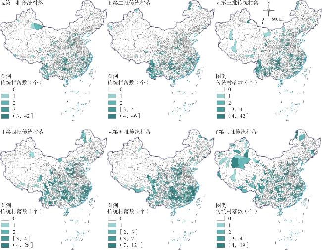
| 1 | 中国传统村落数据 | 利用Global Mapper软件反演得到点位数据 | 住房和城乡建设部等部门公布的第一至第六批中国传统村落名单[23] |
| 2 | 行政边界数据 | 县域行政边界界定 | 行政区划图基于自然资源部标准地图服务网站下载的审图号为GS〔2023〕2767号的标准地图制作,底图边界无修改[24] |
| 3 | DEM数据 | 拼接、裁剪、重采样过后得到90 m分辨率的DEM数据 | ASTER GDEM(V2)空间分辨率为30 m[25] |
| 4 | 地貌数据 | 起伏度—海拔二级分类方案作为计算依据 | 2009年版本的《中华人民共和国地貌图集(1∶100万)》,分辨率为1000 m,共包括25类基本地貌类型[26] |
| 5 | 山体走向数据 | 地形特征分析的依据 | 中国科学院、水利部成都山体灾害与环境研究所于2015年发布的《中国数字山地图》[27] |
表2 中国传统村落数量与密度关系Tab.2 Relationship between the number and density of traditional Chinese villages |
| 数量(个) | 数量排名 | 市域 | 县域 | 密度 | 密度排名 | |
|---|---|---|---|---|---|---|
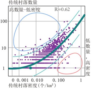 | 164 | 1 | 黄山市 | 歙县 | 0.83 | 2 |
| 99 | 2 | 黔东南州 | 黎平县 | 0.25 | 27 | |
| 95 | 3 | 保山市 | 腾冲市 | 0.19 | 42 | |
| 78 | 5 | 丽水市 | 松阳县 | 0.61 | 5 | |
| 78 | 4 | 黔东南州 | 从江县 | 0.27 | 25 | |
| 68 | 6 | 黔东南州 | 雷山县 | 0.62 | 3 | |
| 60 | 7 | 晋城市 | 高平市 | 0.61 | 4 | |
| 59 | 8 | 晋城市 | 泽州县 | 0.29 | 18 | |
| 56 | 9 | 丽水市 | 景宁畲族自治县 | 0.31 | 15 | |
| 55 | 10 | 抚州市 | 金溪县 | 0.44 | 10 |
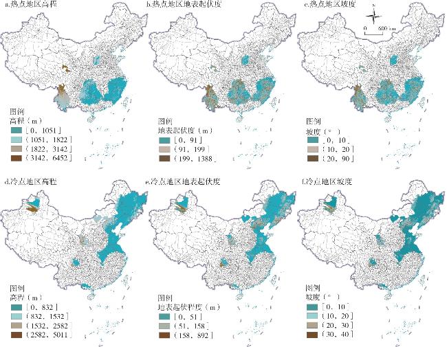
表3 中国传统村落冷热点区域主要地貌的比例Tab.3 Proportion of major landforms in coldspot and hotspot regions of traditional Chinese villages |
| 地貌类型 | 热点 | A | B | C | D | E | 冷点 | A | B | C | D | E | ||
|---|---|---|---|---|---|---|---|---|---|---|---|---|---|---|
| 低海拔平原 | 0.06 | 0.14 | 0.03 | 0.00 | 0.10 | 0.01 | 0.35 | 0.05 | 0.13 | 0.00 | 0.40 | 0.27 | ||
| 低海拔丘陵 | 0.09 | 0.14 | 0.11 | 0.00 | 0.04 | 0.00 | 0.15 | 0.35 | 0.28 | 0.00 | 0.15 | 0.16 | ||
| 低海拔台地 | 0.05 | 0.08 | 0.05 | 0.00 | 0.11 | 0.00 | 0.13 | 0.18 | 0.16 | 0.02 | 0.15 | 0.04 | ||
| 中海拔平原 | 0.01 | 0.00 | 0.00 | 0.00 | 0.01 | 0.02 | 0.04 | 0.00 | 0.00 | 0.11 | 0.03 | 0.09 | ||
| 中海拔丘陵 | 0.02 | 0.00 | 0.02 | 0.00 | 0.11 | 0.02 | 0.04 | 0.00 | 0.01 | 0.44 | 0.02 | 0.04 | ||
| 中海拔台地 | 0.01 | 0.00 | 0.00 | 0.00 | 0.09 | 0.00 | 0.02 | 0.00 | 0.00 | 0.17 | 0.01 | 0.01 | ||
| 高海拔平原 | 0.00 | 0.00 | 0.00 | 0.03 | 0.00 | 0.00 | 0.00 | 0.00 | 0.00 | 0.00 | 0.00 | 0.00 | ||
| 高海拔丘陵 | 0.00 | 0.00 | 0.00 | 0.02 | 0.00 | 0.00 | 0.00 | 0.00 | 0.00 | 0.00 | 0.00 | 0.00 | ||
| 高海拔台地 | 0.00 | 0.00 | 0.00 | 0.01 | 0.00 | 0.00 | 0.00 | 0.00 | 0.00 | 0.00 | 0.00 | 0.00 | ||
| 小起伏低山 | 0.19 | 0.25 | 0.28 | 0.00 | 0.01 | 0.01 | 0.10 | 0.12 | 0.33 | 0.00 | 0.11 | 0.00 | ||
| 小起伏中山 | 0.10 | 0.02 | 0.11 | 0.00 | 0.26 | 0.16 | 0.05 | 0.01 | 0.05 | 0.14 | 0.05 | 0.05 | ||
| 小起伏高山 | 0.01 | 0.00 | 0.00 | 0.26 | 0.00 | 0.00 | 0.00 | 0.00 | 0.00 | 0.00 | 0.00 | 0.02 | ||
| 小起伏极高山 | 0.00 | 0.00 | 0.00 | 0.04 | 0.00 | 0.00 | 0.00 | 0.00 | 0.00 | 0.00 | 0.00 | 0.00 | ||
| 中起伏低山 | 0.08 | 0.12 | 0.10 | 0.00 | 0.00 | 0.00 | 0.02 | 0.01 | 0.05 | 0.00 | 0.02 | 0.00 | ||
| 中起伏中山 | 0.26 | 0.19 | 0.23 | 0.00 | 0.24 | 0.47 | 0.07 | 0.18 | 0.01 | 0.12 | 0.06 | 0.10 | ||
| 中起伏高山 | 0.01 | 0.00 | 0.00 | 0.49 | 0.00 | 0.01 | 0.01 | 0.00 | 0.00 | 0.00 | 0.00 | 0.14 | ||
| 中起伏极高山 | 0.00 | 0.00 | 0.00 | 0.05 | 0.00 | 0.00 | 0.00 | 0.00 | 0.00 | 0.00 | 0.00 | 0.00 | ||
| 大起伏中山 | 0.09 | 0.06 | 0.07 | 0.00 | 0.03 | 0.18 | 0.01 | 0.08 | 0.00 | 0.00 | 0.01 | 0.00 | ||
| 大起伏高山 | 0.02 | 0.00 | 0.00 | 0.08 | 0.00 | 0.10 | 0.00 | 0.03 | 0.00 | 0.00 | 0.00 | 0.05 | ||
| 大起伏极高山 | 0.00 | 0.00 | 0.00 | 0.02 | 0.00 | 0.00 | 0.00 | 0.00 | 0.00 | 0.00 | 0.00 | 0.00 | ||
| 极大起伏高山 | 0.00 | 0.00 | 0.00 | 0.00 | 0.00 | 0.01 | 0.00 | 0.00 | 0.00 | 0.00 | 0.00 | 0.00 | ||
| 极大起伏中山 | 0.00 | 0.00 | 0.00 | 0.00 | 0.00 | 0.01 | 0.00 | 0.00 | 0.00 | 0.00 | 0.00 | 0.00 |
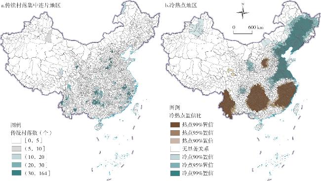
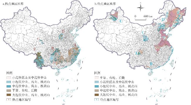
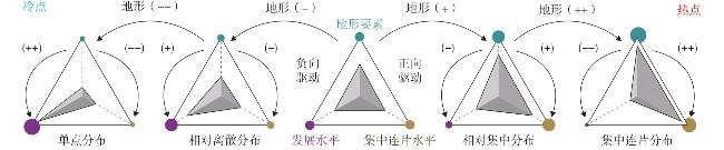
图7 中国传统村落冷热点县区地形要素的空间分布Fig.7 Spatial distribution of topographic features in cold and hot spot counties of traditional Chinese villages |
表4 冷点及热点区域各指标相关性矩阵Tab.4 Correlation of Indicators in Cold Spot and Hot Spot Areas |
| 冷点区域 | 热点区域 | ||||||||||||
|---|---|---|---|---|---|---|---|---|---|---|---|---|---|
| 传统村落密度 | GDP | 人口 | 高程 | 坡度 | 地表起伏度 | 传统村落密度 | GDP | 人口 | 高程 | 坡度 | 地表起伏度 | ||
| 传统村落密度 | 1 | 1 | |||||||||||
| GDP | -0.075 | 1 | -0.147** | 1 | |||||||||
| 人口 | 0.085* | 0.711** | 1 | -0.078* | 0.729** | 1 | |||||||
| 高程 | 0.211** | -0.517** | -0.425** | 1 | 0.140** | -0.551** | -0.435** | 1 | |||||
| 坡度 | 0.268** | -0.378** | -0.359** | 0.845** | 1 | 0.300** | -0.493** | -0.375** | 0.688** | 1 | |||
| 地表起伏度 | 0.966** | -0.11 | 0.074* | 0.234** | 0.287** | 1 | 0.748** | -0.194** | -0.057 | 0.246** | 0.415** | 1 | |
注:* p<0.05 ** p<0.01。 |
| [1] |
胡燕, 陈晟, 曹玮, 等. 传统村落的概念和文化内涵[J]. 城市发展研究, 2014, 21(1):10-13.
|
| [2] |
常光宇, 胡燕. 探索传统村落集群式保护发展[J]. 城市发展研究, 2020, 27(12):7-11.
|
| [3] |
史东霞, 王金平. 精明收缩视角下传统村落集中连片规划方法探索——以山西省阳泉市平定县为例[J]. 小城镇建设, 2022, 40(12):70-76.
|
| [4] |
张菁, 林冰姚, 陈秋渝, 等. 渝东南传统村落景观集群集中连片保护体系研究[J]. 南方建筑, 2023(10):98-107.
|
| [5] |
薛乾明, 黄跃昊. 传统村落集中连片保护利用格局构建方法——以甘肃省两当县为例[J]. 规划师, 2024, 40(8):66-74.
|
| [6] |
张大玉, 张文君, 陈丹良. 新时期传统乡村聚落保护发展集群模式的理念辨析和思路探索[J]. 城市发展研究, 2022, 29(4):16-21,39.
|
| [7] |
陈彬, 王巧玲. 传统村落集中连片保护利用的实施路径[J]. 中国土地, 2022(5):43-45.
|
| [8] |
张文君, 陈丹良, 张大玉. 社会有机体理论视角下的县域传统村落集群保护发展方法研究[J]. 小城镇建设, 2022, 40(9):111-119.
|
| [9] |
住房和城乡建设部、财政部. 做好2022年传统村落集中连片保护利用示范工作[J]. 住宅产业, 2022(4):5-6.
|
| [10] |
凡来, 张大玉, 李雪华, 等. 集中连片视角下的传统村落保护利用协同发展研究——以北京门头沟为例[J]. 中国园林, 2025, 41(4):79-86.
|
| [11] |
刘大均, 胡静, 陈君子, 等. 中国传统村落的空间分布格局研究[J]. 中国人口·资源与环境, 2014, 24(4):157-162.
|
| [12] |
李伯华, 尹莎, 刘沛林, 等. 湖南省传统村落空间分布特征及影响因素分析[J]. 经济地理, 2015, 35(2):189-194.
|
| [13] |
薛明月, 王成新, 窦旺胜, 等. 黄河流域传统村落空间分布特征及其影响因素研究[J]. 干旱区资源与环境, 2020, 34(4):94-99.
|
| [14] |
佟玉权. 基于GIS的中国传统村落空间分异研究[J]. 人文地理, 2014, 29(4):44-51.
|
| [15] |
康璟瑶, 章锦河, 胡欢, 等. 中国传统村落空间分布特征分析[J]. 地理科学进展, 2016, 35(7):839-850.
|
| [16] |
佟玉权, 龙花楼. 贵州民族传统村落的空间分异因素[J]. 经济地理, 2015, 35(3):133-137,93.
|
| [17] |
孙军涛, 牛俊杰, 张侃侃, 等. 山西省传统村落空间分布格局及影响因素研究[J]. 人文地理, 2017, 32(3):102-107.
|
| [18] |
卢松, 张小军, 张业臣. 徽州传统村落的时空分布及其影响因素[J]. 地理科学, 2018, 38(10):1690-1698.
|
| [19] |
吴传钧. 论地理学的研究核心——人地关系地域系统[J]. 经济地理, 1991(3):1-6.
|
| [20] |
梁步青, 肖大威, 陶金, 等. 赣州客家传统村落分布的时空格局与演化[J]. 经济地理, 2018, 38(8):196-203.
|
| [21] |
周蕾, 熊礼阳, 王一晴, 等. 中国贫困县空间格局与地形的空间耦合关系[J]. 经济地理, 2017, 37(10):157-166.
|
| [22] |
胡焕庸. 中国人口之分布——附统计表与密度图[J]. 地理学报, 1935(2):33-74.
|
| [23] |
住房和城乡建设部. 传统村落网[EB/OL]. http://www.chuantongcunluo.com/index.php/Home/gjml/gjml/wid/2506.html,2023-03-19.
|
| [24] |
自然资源部地图技术审查中心. 标准地图服务系统[EB/OL]. http://bzdt.ch.mnr.gov.cn.
|
| [25] |
武文娇, 章诗芳, 赵尚民. SRTM1 DEM与ASTER GDEM V2数据的对比分析[J]. 地球信息科学学报, 2017, 19(8):1108-1115.
|
| [26] |
周成虎, 程维明. 《中华人民共和国地貌图集》的研究与编制[J]. 地理研究, 2010, 29(6):970-979.
|
| [27] |
邓伟, 李爱农, 南希, 等. 中国数字山地图[M]. 北京: 中国地图出版社, 2015.
|
| [28] |
陈彦光. 基于Moran统计量的空间自相关理论发展和方法改进[J]. 地理研究, 2009, 28(6):1449-1463.
|
/
| 〈 |
|
〉 |
