
山区镇域空间功能冲突与权衡协同——以茶陵县严塘镇为例
|
傅丽华(1971—),女,博士,教授,研究方向为国土空间规划与管理、景观生态与土地利用、旅游规划。E-mail: lihuaf88@163.com |
收稿日期: 2024-11-22
修回日期: 2025-06-01
网络出版日期: 2026-02-04
基金资助
国家自然科学基金面上项目(42371288)
地理学应用特色学科([2022]351)
Spatial Function Conflicts and Trade-off/Synergy Strategies in Mountainous Towns: A Case Study of Yantang Town in Chaling County
Received date: 2024-11-22
Revised date: 2025-06-01
Online published: 2026-02-04
傅丽华 , 谭贵 , 莫振淳 . 山区镇域空间功能冲突与权衡协同——以茶陵县严塘镇为例[J]. 经济地理, 2025 , 45(12) : 95 -104 . DOI: 10.15957/j.cnki.jjdl.2025.12.010
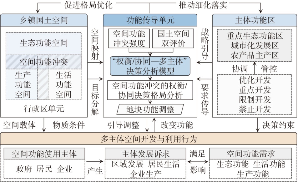
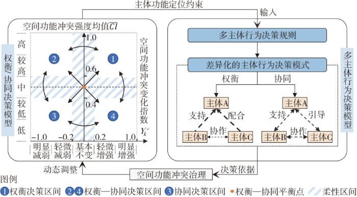
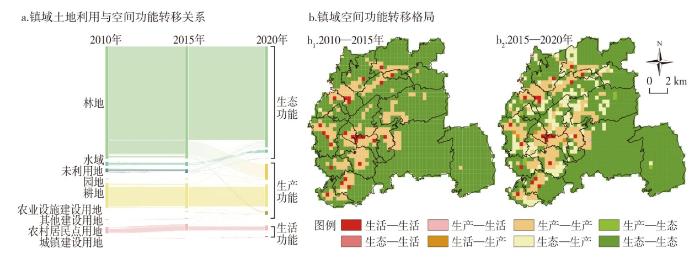
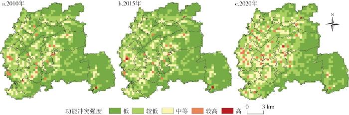
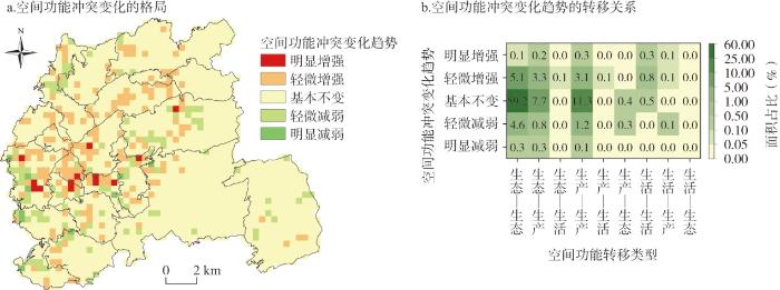
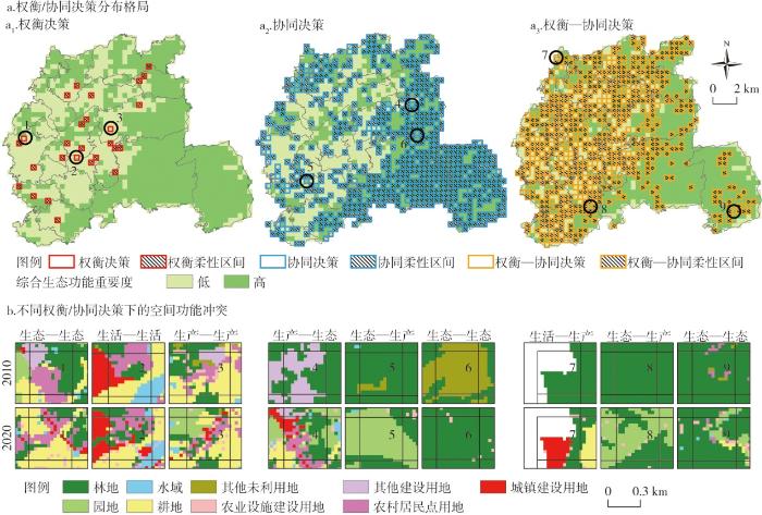
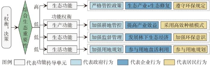
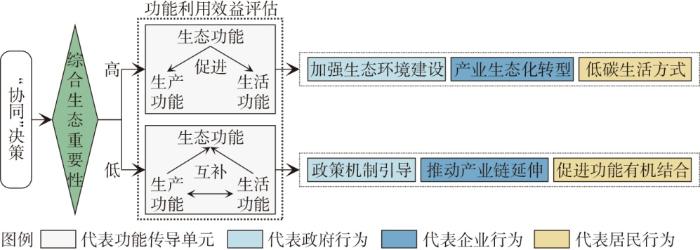
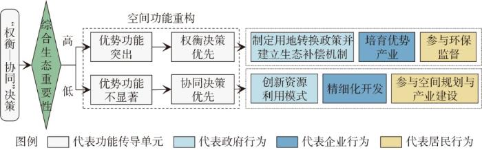
Based on the land use data from 2010-2020 and the "dual evaluation" data of territorial space of Yantang Town, and combining the identification of functional transmission units and the measurement of spatial functional conflict intensity, this study analyzed the logical relationship between the requirements of main functional zones and the decision-making behaviors of multiple stakeholders through analyzing changes in spatial functional conflicts. On the basis of the above, it constructed a trade-off/collaboration decision-making analysis framework and a "trade-off/collaboration and multi-stakeholder" behavioral decision-making model for spatial functional conflicts, and proposed decision-making models for spatial functional conflicts that adapt to different functional transmission units. The results indicate that: 1) The spatial functional of Yantang Town demonstrates pronounced east-west differentiation patterns. The overall intensity of spatial functional conflicts is relatively low in Yantang Town. The spatial functional conflicts show a clear directional pattern in their agglomeration and diffusion. 2) The spatial patterns of trade-off/collaboration decision-making for spatial functional conflicts at the town level, the intensity changes of these conflicts, and the importance of comprehensive ecological function show a strong spatial correlation. Meanwhile, the trade-off/synergy decision-making spatial pattern exhibits pronounced east-west differentiation characteristic. 3) The behavioral decision-making of multiple stakeholders at the township level demonstrates a spatial correspondence with the varying intensities of functional conflicts. Three distinct decision-making models are proposed for different units: the "multi-stakeholder trade-off" model, the "multi-stakeholder synergy" model, and the "multi-stakeholder trade-off and synergy" model.
表1 国土空间用地类型与空间功能分类转换Tab.1 Classification and conversion of land spatial land use types and spatial functions |
| 国土变更调查地类名称 | 对应土地利用景观类型 | 空间功能类型 |
|---|---|---|
| 农村宅基地、村庄用地 | 农村居民点用地 | 生活功能 |
| 建制镇、城镇村、工业、公路、城镇住宅、公用设施、商业服务业设施 | 城镇建设用地 | |
| 采矿、水工建筑、风景名胜及特殊用地 | 其他建设用地 | 生产功能 |
| 干渠、沟渠、农村道路、设施农用地 | 农业设施建设用地 | |
| 水田、旱地、水浇地 | 耕地 | |
| 其他园地、茶园、果园 | 园地 | |
| 其他林地、灌木、乔木、竹林 | 林地 | 生态功能 |
| 裸地、其他草地 | 未利用地 | |
| 坑塘、河流、水库、滩涂 | 水域 |
表2 空间功能冲突强度评价指标及计算方法Tab.2 Measurement index and calculation method of spatial function conflict intensity |
| 指标名称 | 指标含义 | 指标计算方法 | |
|---|---|---|---|
| 空间功能斑块 复杂度(FC) | 反映外部干扰对功能斑块的影响。外部干扰越强,空间功能斑块复杂度越高 | $FC=\sum _{u=1}^{3}\sum _{k=1}^{1460}\left[\frac{2ln\left(0.25{P}_{uk}\right)}{ln{a}_{uk}}\left(\frac{{a}_{uk}}{A}\right)\right]$ | 式中:Puk为第k个单元中u类空间功能斑块的周长;aik为第k个单元中u类空间功能斑块面积;A为单个功能传导单元面积 |
| 空间功能斑块 破碎度(FF) | 体现空间功能完整性和空间功能强弱。破碎度越高,则空间主导功能越弱 | $FF=\left(1-\frac{LPI}{100}\right)\cdot NP$,$LPI=\frac{{a}_{kmax}}{A}\cdot 100$ | 式中:LPI为最大空间功能斑块指数,NP为斑块总数;akmax为第k个单元中最大空间功能斑块面积;A为单个功能传导单元面积 |
| 空间功能斑块 离散度(FD) | 表示斑块分离程度,数值越小代表斑块集聚程度越高,越利于空间功能发挥 | $FD=1-\sum _{u=1}^{3}\left(\frac{{d}_{uk}}{{A}_{u}}\right)$ | 式中:dik为第k个单元中u类空间功能斑块间的距离;A为单个功能传导单元面积 |
| 空间功能脆弱 度(FV) | 反映外部干扰下某一空间功能的类型、形态或结构改变的难易程度,脆弱度越高,越易受外界影响 | $FV=\sum _{u=1}^{3}{F}_{u}\cdot \frac{{a}_{uk}}{A}$ | 式中:auk为第k个单元中u类空间功能斑块面积;Fu为u类空间功能抗干扰能力,从低到高依次为未利用地<水域<园地<耕地<林地<农业设施建设用地<其他建设用地<农村居民点用地<城镇建设用地,依次赋分1~9 |
| 空间功能冲突 强度(CI) | 指在特定区域内不同空间功能的冲突程度,反映了空间功能之间的相互作用和竞争态势 | $CI=\alpha FC\text{'}+\beta FF\text{'}+\gamma FD\text{'}+\eta FV\text{'}$ | 式中:FC′、FF′、FD′、FV′为归一化后的FC、FF、FD、FV;α、β、γ、η为指标权重,通过层次分析法计算,分别为0.08、0.27、0.51、0.14;CI取值[0,1],采用等距法划分为低[0,0.2)、较低[0.2,0.4)、中等[0.4,0.6)、较高[0.6,0.8)、高[0.8,1.0]5个等级 |
| [1] |
|
| [2] |
|
| [3] |
宋复蓉, 曾向阳, 陈勇. 矿粮复合区“三生”空间冲突诊断及演化特征分析——以大冶市陈贵镇为例[J]. 水土保持研究, 2024, 31(2):401-412.
|
| [4] |
凌子燕, 李延顺, 蒋卫国, 等. 山江海交错带城市群国土三生空间动态变化特征——以广西北部湾城市群为例[J]. 经济地理, 2022, 42(2):18-24.
|
| [5] |
张潇, 谷人旭. 土地利用冲突的时空格局刻画与多情景模拟研究——以长江三角洲城市群为例[J]. 地理研究, 2022, 41(5):1311-1326.
|
| [6] |
樊杰, 赵艳楠. 面向现代化的中国区域发展格局:科学内涵与战略重点[J]. 经济地理, 2021, 41(1):1-9.
|
| [7] |
陈磊, 姜海. 从土地资源优势区配置到主体功能区管理:一个国土空间治理的逻辑框架[J]. 中国土地科学, 2019, 33(6):10-17.
|
| [8] |
祁帆, 邱思齐, 赵成双苹, 等. 在国土空间规划中完善主体功能区政策制度[J]. 中国科学院院刊, 2024, 39(4):714-725.
|
| [9] |
巩垠熙, 董志海, 吕慧玲, 等. 市县国土空间规划主体功能区划定方法研究[J]. 测绘科学, 2021, 46(3):183-191.
|
| [10] |
贺慧, 张彤, 张庆昊, 等. 国家文化公园主体功能区识别路径构建——以长江国家文化公园湖北段为例的实证研究[J]. 中国园林, 2024, 40(7):38-44.
|
| [11] |
李辉, 苏昌贵, 魏晓. 省级主体功能区规划实施效果评估与政策启示——以《湖南省主体功能区规划》实施为例[J]. 经济地理, 2022, 42(5):45-55.
|
| [12] |
尹力, 魏伟, 薄立明, 等. 基于主体功能区战略的新疆地区“三区空间”演化解析[J]. 经济地理, 2023, 43(7):52-64.
|
| [13] |
薄立明, 尹力, 魏伟, 等. 主体功能区视角下山东省国土空间格局演变及驱动因素分析[J]. 地理与地理信息科学, 2024, 40(1):37-46.
|
| [14] |
夏四友, 杨宇. 基于主体功能区的京津冀城市群碳收支时空分异与碳补偿分区[J]. 地理学报, 2022, 77(3):679-696.
|
| [15] |
叶菁, 黄川悦, 陶荣, 等. 主体功能区战略在国土空间总体规划中的传导管控策略[J]. 规划师, 2024, 40(6):23-30.
|
| [16] |
|
| [17] |
李建春, 高玉婷, 曲衍波, 等. 陆海统筹视域下国土空间多维冲突识别与分区调控——以莱州市为例[J]. 地理科学, 2022, 42(7):1155-1165.
|
| [18] |
潘方杰, 万庆, 曾菊新, 等. 城镇化进程中湖北省“生产—生活—生态”空间冲突演化及其影响因素[J]. 经济地理, 2023, 43(2):80-92.
|
| [19] |
|
| [20] |
李彦平, 陈逸洋, 刘大海, 等. 海域立体分层利用的空间冲突及管理——基于时空行为视角[J]. 自然资源学报, 2023, 38(10):2475-2489.
|
| [21] |
|
| [22] |
|
| [23] |
|
| [24] |
|
| [25] |
|
| [26] |
董光龙, 王珏, 王克强, 等. 基于土地利用偏好与位置重要性的农业土地利用冲突识别与调解[J]. 地理研究, 2024, 43(8):1994-2009.
|
| [27] |
曲衍波, 王世磊, 李岩, 等. 基于多功能适宜性的黄河三角洲国土空间潜在冲突特征与优化格局研究[J]. 地理科学, 2023, 43(2):301-312.
|
| [28] |
杨兴柱, 余海燕, 殷程强, 等. 乡村旅游地利益主体多功能空间认知的冲突与协调机制——以黄山风景区山岔村为例[J]. 地理学报, 2023, 78(6):1530-1552.
|
| [29] |
|
| [30] |
田俊峰, 王彬燕, 王士君. 土地利用冲突研究的逻辑主线与内容框架[J]. 资源科学, 2023, 45(3):465-479.
|
| [31] |
王越, 李佩泽, 李炆颖, 等. 基于演化博弈的土地利用冲突缓解机制研究——以沈抚新区为例[J]. 中国土地科学, 2021, 35(12):87-97.
|
| [32] |
周国华, 彭佳捷. 空间冲突的演变特征及影响效应——以长株潭城市群为例[J]. 地理科学进展, 2012, 31(6):717-723.
|
| [33] |
樊杰. 地域功能—结构的空间组织途径——对国土空间规划实施主体功能区战略的讨论[J]. 地理研究, 2019, 38(10):2373-2387.
|
| [34] |
汪洋, 王力力, 祁鹏卫, 等. 重庆市主体功能区识别的主导因素与空间稳定性约束机理[J]. 地理学报, 2019, 74(1):44-62.
|
| [35] |
樊杰, 周侃. 以“三区三线”深化落实主体功能区战略的理论思考与路径探索[J]. 中国土地科学, 2021, 35(9):1-9.
|
/
| 〈 |
|
〉 |