
基于格网分析的长沙城市空间破碎化分异机理
|
朱佩娟(1974—),女,湖南岳阳人,硕士,副教授,硕士生导师。主要研究方向为人文地理与城乡空间结构。E-mail:mrs-zhu@163.com。 |
收稿日期: 2019-08-15
修回日期: 2020-04-13
网络出版日期: 2025-05-14
基金资助
湖南省重点领域研发计划项目(2019SK2101)
The Mechanism of Spatial Fragmentation and Differentiation in Changsha Based on Grid Analysis
Received date: 2019-08-15
Revised date: 2020-04-13
Online published: 2025-05-14
朱佩娟 , 张美芳 , 贺清云 , 郎泽慧 , 吴国权 . 基于格网分析的长沙城市空间破碎化分异机理[J]. 经济地理, 2020 , 40(6) : 116 -125 . DOI: 10.15957/j.cnki.jjdl.2020.06.013
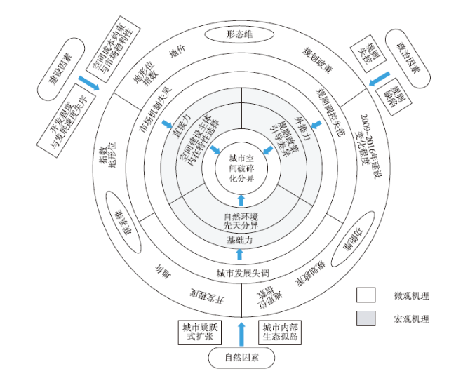
The fragmentation of urban space affects the overall function and quality of the city. Analyzing the spatial differentiation mechanism of fragmentation of urban space helps to deepen the understanding of urban spatial structure theory.Taking Changsha as the research object,the spatial differentiation of spatial fragmentation is measured based on the 1 km×1 km grid. Combined with the ordered multi-purpose logistic regression model,the dominant factors affecting spatial fragmentation are identified,and the spatial differentiation mechanism of spatial fragmentation is revealed.The results show that:1) The spatial difference of spatial fragmentation in Changsha is significant,and the areas with higher fragmentation are distributed in scattered points. 2) The types of spatial fragmentation in Changsha can be divided into residential,industrial,ecological,and special types.Among them,ecological fragmented type and residential fragmented type account for a relatively high proportion,and the spatial distribution of different fragmented types is obviously different. 3) The five factors of topography index,development degree,2009-2016 construction change degree,land price,and planning policy are the dominant factors for the fragmentation and differentiation of urban space.The fragmentation index of the three dimensions of form,connection and function is affected by various factors. 4) The increase of the level of spatial fragmentation mainly stems from three aspects:One is the effect of topography and topography on the division of urban space,the second is the degree of disorder of the main behavior of the construction,and the third is the impact of out-of-control planning and planning defects in local areas.The interaction of basic forces (inherent differentiation of the natural environment),direct forces (selection of the internal characteristics of the main body of space construction) and external driving forces (differences in planning policies) jointly promotes the change of the fragmentation pattern of urban space.
表1 城市空间破碎化评价指标Tab.1 Evaluation index of spatial fragmentation |
| 准则层 | 维度 | 指标参数 | 指标方向 | 计算方式 | 指标含义 |
|---|---|---|---|---|---|
| 空间隔离特征 | 空间形态 | 平均地块面积指数(MBA) | + | 空间形态封闭分割程度 | |
| 空间联系 | 空间联系阻隔指数(SCB) | + | 空间联系阻隔程度 | ||
| 空间功能 | 功能多样指数(FD) | - | 空间功能单一孤立程度 |
注:1.MBA和SCB与城市空间破碎化水平呈正相关,指标性质为“+”;FD与城市空间破碎化水平呈负相关,指标性质为“-”。2.MBA为平均地块面积指数,A表示研究单元土地总面积(hm2),N表示研究单元地块总数量。3.SCB为空间联系阻隔指数,r为尺度半径,本模型中的r尺度半径取值为主干道间距1 200 m+步长值600 m=1 800 m。σ是步长(一般较小),特指两个尺度半径之间的差值,根据长沙市城市空间的实际情况来看,现状路网间距在300~1 000 m左右,为准确刻画其变化特征,步长取值600m,C为指定距离内连接到的道路数,n为地块边缘道路网格数量,A为地块面积。4.FD为功能多样指数[28],取值范围为[0,1],r为功能要素状态(样方)数,k为功能要素类型数量, 表示第k种功能要素在街道i中的数量占比,Xk为第k类功能要素的数量。 |
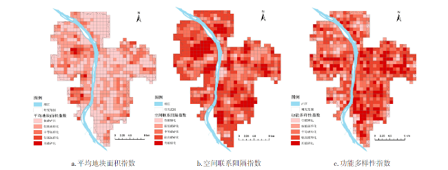
图2 长沙市分指数破碎化水平的空间分异特征Fig.2 Spatial differentiation characteristics of sub-exponential fragmentation levels in Changsha |
表2 各类指数空间集聚统计Tab.2 Various index space agglomeration statistics |
| 指数 | Moran's I | 预期指数 | 方差 | Z得分 | P值 |
|---|---|---|---|---|---|
| 平均地块面积指数 | 0.39 | -0.0014 | 0.0007 | 14.4164 | 0.0000 |
| 空间联系阻隔指数 | 0.32 | -0.0014 | 0.0007 | 11.5315 | 0.0000 |
| 功能多样性指数 | 0.55 | -0.0014 | 0.0007 | 19.8078 | 0.0000 |
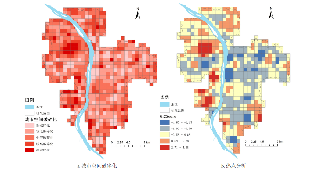
图3 长沙市综合破碎化水平的空间分异特征Fig.3 Spatial differentiation characteristics of comprehensive fragmentation level in Changsha |
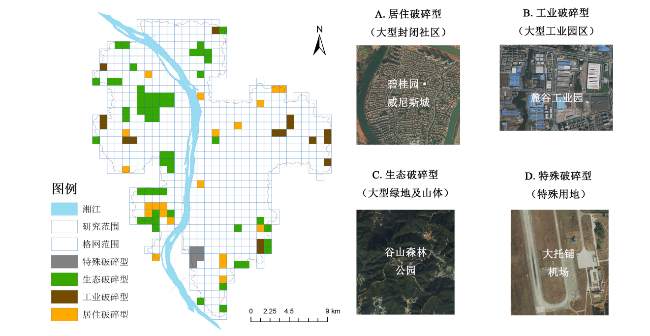
表3 长沙市城市空间破碎化高值区分类Tab.3 Classification of high-value areas of spatial fragmentation in Changsha |
| 类型 | 个数 | 占比% | 地块规模(km2) | 性质 | 破碎化值 | ||||
|---|---|---|---|---|---|---|---|---|---|
| 最高值 | 最低值 | 平均值 | 最高值 | 最低值 | 平均值 | ||||
| 居住破碎型 | 21 | 21 | 0.92 | 0.06 | 0.61 | 大型封闭社区 | 2.20 | 1.34 | 1.48 |
| 工业破碎型 | 16 | 16 | 0.94 | 0.57 | 0.74 | 大型工业园区 | 1.66 | 1.34 | 1.46 |
| 生态破碎型 | 58 | 58 | 0.96 | 0.00 | 0.59 | 大型绿地及山体 | 2.27 | 1.34 | 1.56 |
| 特殊破碎型 | 5 | 5 | 0.99 | 0.82 | 0.89 | 城市特殊用地 | 1.85 | 1.45 | 1.62 |
表4 城市空间破碎化影响因素及其含义Tab.4 Influencing factors and their meanings of spatial fragmentation |
| 变量 | 含义 |
|---|---|
| 地形位指数(X1) | 海拔(m)及坡度(°) |
| 区位(X2) | 到市中心的欧式距离(km) |
| 开发程度(X3) | 建设用地比例(%) |
| 2000—2009年建设变化程度(X4) | 2000—2009年建设用地变化率(%) |
| 2009—2016年建设变化程度(X5) | 2009—2016年建设用地变化率(%) |
| 地价(X6) | 土地基准地价等级(Ⅰ、Ⅱ、Ⅲ、Ⅳ、Ⅴ、Ⅵ) |
| 公交可达性(X7) | 公交站点可达性(km) |
| 公共服务设施可达性(X8) | 大型教育、医疗、商业服务设施综合可达性(km) |
| 规划政策(X9) | “0”=规划建设用地,“1”=非规划建设用地 |
| 空间政策主体数量(X10) | “0”=无开发区或高教区,“1”=有开发区或高教区 |
表5 城市空间破碎化有序多分类Logistic回归结果Tab.5 Ordered multi-class Logistic regression results for spatial fragmentation |
| 变量 | OR | 标准误 | Wald | 显著性 水平 | 95%置信区间 | 形态维 显著性水平 | 联系维 显著性水平 | 功能维 显著性水平 | ||
|---|---|---|---|---|---|---|---|---|---|---|
| 下限 | 上限 | |||||||||
| 地形位指数(X1) | 26.390 | 0.795 | 16.957 | 0.000 | -1.715 | 4.832 | 0.004 | 0.000 | 0.000 | |
| 区位(X2) | 1.000 | 2.824E-5 | 0.002 | 0.963 | -5.665E-5 | 5.403E-5 | 0.736 | 0.562 | 0.482 | |
| 开发程度(X3) | 0.119 | 0.318 | 44.513 | 0.000 | -2.749 | -1.500 | 0.022 | 0.005 | 0.175 | |
| 2000—2009年建设变化程度(X4) | 0.945 | 0.063 | 0.804 | 0.370 | -2.749 | -1.500 | 0.181 | 0.523 | 0.328 | |
| 2009—2016年建设变化程度(X5) | 1.655 | 0.174 | 8.374 | 0.004 | 0.163 | 0.846 | 0.016 | 0.181 | 0.000 | |
| 地价(X6=Ⅰ) | 0a | - | - | - | - | - | - | - | - | |
| 地价(X6=Ⅱ) | 5.529 | 0.648 | 6.964 | 0.008 | 0.440 | 2.980 | 0.000 | 0.005 | 0.096 | |
| 地价(X6=Ⅲ) | 4.354 | 0.725 | 4.117 | 0.042 | 0.050 | 2.893 | 0.138 | 0.052 | 0.066 | |
| 地价(X6=Ⅳ) | 5.018 | 0.761 | 4.492 | 0.034 | 0.121 | 3.104 | 0.121 | 0.039 | 0.087 | |
| 地价(X6=Ⅴ) | 4.960 | 0.786 | 3.213 | 0.073 | -0.132 | 2.951 | 0.251 | 0.089 | 0.057 | |
| 地价(X6=Ⅵ) | 5.452 | 0.796 | 4.536 | 0.033 | 0.135 | 3.256 | 0.042 | 0.023 | 0.073 | |
| 公交可达性(X7) | 1.000 | 5.025E-5 | 0.297 | 0.085 | -7.108E-5 | 0.000 | 0.309 | 0.708 | 0.867 | |
| 公共服务设施可达性(X8) | 1.000 | 4.626E-5 | 0.008 | 0.928 | -9.487E-5 | 8.649E-5 | 0.241 | 0.812 | 0.688 | |
| 规划政策(X9=0) | 0a | - | - | - | - | - | - | - | - | |
| 规划政策(X9=1) | 0.280 | 0.200 | 40.491 | 0.000 | -1.665 | -0.881 | 0.005 | 0.062 | 0.000 | |
| 空间政策主体数量(X10=0) | 0a | - | - | - | - | - | - | - | - | |
| 空间政策主体数量(X10==1) | 0.853 | 0.217 | 0.538 | 0.463 | -0.585 | 0.266 | 0.346 | 0.401 | 0.516 | |
| [1] |
孙斌栋, 华杰媛, 李琬, 等. 中国城市群空间结构的演化与影响因素——基于人口分布的形态单中心—多中心视角[J]. 地理科学进展, 2017, 36(10):1294-1 303.
|
| [2] |
张尔薇. 评《世界城市和城市形态——空间破碎化、多中心、可持续发展》[J]. 城市与区域规划研究, 2010, 3(3):217-220.
|
| [3] |
周国华, 彭佳捷. 空间冲突的演变特征及影响效应——以长株潭城市群为例[J]. 地理科学进展, 2012, 31(6):717-723.
|
| [4] |
Janoschka, Michael. El nuevo modelo de la ciudad latinoameri-cana:fragmentación y privatización[J]. Eure Revista Latinoamericana De Estudios Urbano Regionales, 2002, 28(85):11-20.
|
| [5] |
|
| [6] |
韦亚平, 张晨, 张宗彝, 等. 一种测度城镇建设用地碎化的指数方法[J]. 城市规划, 2011, 35(6):41-49.
|
| [7] |
|
| [8] |
|
| [9] |
|
| [10] |
楚静, 王兴中, 李开宇. 大都市郊区化下的社会空间分异、社区碎化与治理[J]. 城市发展研究, 2011, 18(3):112-116.
|
| [11] |
|
| [12] |
|
| [13] |
|
| [14] |
李昕昕, 朱佩娟, 秦书茜, 等. 基于网络房产数据的住区规模时空特征研究——以长沙市为例[J]. 现代城市研究, 2018(1):86-92.
|
| [15] |
丁成日. 城市空间结构和用地模式对城市交通的影响[J]. 城市交通, 2010, 8(5):28-35.
|
| [16] |
马学广, 王爱民, 闫小培. 城市空间重构进程中的土地利用冲突研究——以广州市为例[J]. 人文地理, 2010, 25(3):72-77.
|
| [17] |
梅林, 孙春暖. 东北地区煤炭资源型城市空间结构的重构——以辽源市为例[J]. 经济地理, 2006, 26(6):949-952.
|
| [18] |
朱佩娟, 贺清云, 朱翔, 等. 论城市空间破碎化研究[J]. 地理研究, 2018, 37(3):480-494.
|
| [19] |
周国华, 贺艳华. 长沙城市土地扩张特征及影响因素[J]. 地理学报, 2006, 61(11):1171-1 180.
|
| [20] |
王海军, 翟丽君, 刘艳芳, 等. 基于多维城市要素流的武汉城市圈城市联系与功能分析[J]. 经济地理, 2018, 38(7):50-58.
|
| [21] |
刘和涛, 田玲玲, 田野, 等. 武汉市城市蔓延的空间特征与管治[J]. 经济地理, 2015, 35(4):47-53.
|
| [22] |
黄晓军, 王晨, 胡凯丽. 快速空间扩张下西安市边缘区社会脆弱性多尺度评估[J]. 地理学报, 2018(6): 1 002-1 017.
|
| [23] |
李也, 龚咏喜, 张兆东, 等. 基于矢量网格的城市土地利用邻里模式研究[J]. 地理学报, 2018, 73(11):2236-2 249.
|
| [24] |
高军波, 韩勇, 喻超, 等. 个体行为视角下中小城市居民就医空间及社会分异研究——兼议与特大城市比较[J]. 人文地理, 2018, 33(6):28-34.
|
| [25] |
周春山, 边艳, 张国俊, 等. 广州市中产阶层聚居区空间分异及形成机制[J]. 地理学报, 2016(12): 2 089-2 102.
|
| [26] |
杨滔. 一种城市分区的空间理论[J]. 国际城市规划, 2015, 30(3):43-52.
|
| [27] |
渠爱雪, 卞正富. 徐州城市建设用地空间格局特征及其演化[J]. 地理研究, 2011(10): 1 783-1 794.
|
| [28] |
党云晓, 董冠鹏, 余建辉, 等. 北京土地利用混合度对居民职住分离的影响[J]. 地理学报, 2015, 70(6):919-930.
|
| [29] |
石忆邵, 尹昌应, 王贺封, 等. 城市综合承载力的研究进展及展望[J]. 地理研究, 2013, 32(1):133-145.
|
| [30] |
张璐璐, 赵金丽, 宋金平. 京津冀城市群物流企业空间格局演化及影响因素[J]. 经济地理, 2019, 39(3):125-133.
|
| [31] |
李洪, 宫兆宁, 赵文吉, 等. 基于Logistic回归模型的北京市水库湿地演变驱动力分析[J]. 地理学报, 2012, 67(3):357-367.
|
| [32] |
盛科荣, 樊杰. 地域功能的生成机理:基于人地关系地域系统理论的解析[J]. 经济地理, 2018, 38(5):11-19.
|
/
| 〈 |
|
〉 |