
近百年来华北县域村级人口的演变——以山西省平遥县为例
|
李庆鹏(1997—),男,博士研究生,研究方向为历史地理学、文化遗产保护。E-mail:liqp@snnu.edu.cn |
收稿日期: 2024-04-26
修回日期: 2024-10-07
网络出版日期: 2025-05-12
基金资助
国家重点研发计划课题(2019YFD1100901)
国家社会科学基金西部项目(19XZS033)
Evolution of Village-level Population in North China in 1920-2010 : A Case of Pingyao County in Shanxi Province
Received date: 2024-04-26
Revised date: 2024-10-07
Online published: 2025-05-12
李庆鹏 , 周宏伟 . 近百年来华北县域村级人口的演变——以山西省平遥县为例[J]. 经济地理, 2025 , 45(2) : 91 -102 . DOI: 10.15957/j.cnki.jjdl.2025.02.009
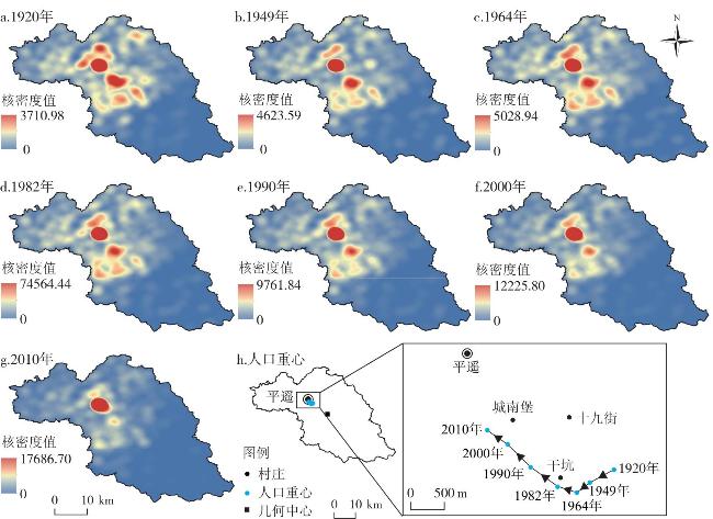
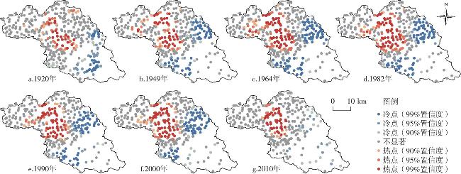
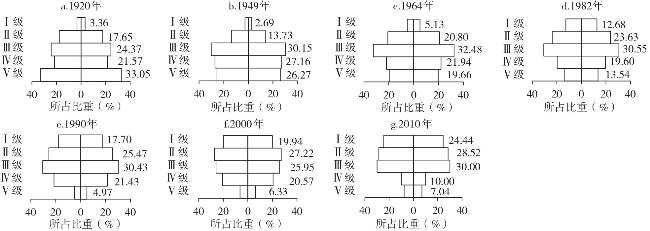
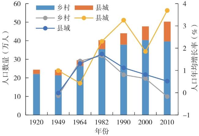
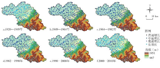
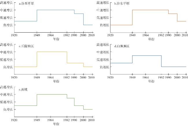
Based on the population data of Pingyao County for 7 periods since the Republic of China, this paper analyzes the spatio-temporal evolution characteristics, influencing factors and mechanism of the village-level population in Pingyao County of North China in 1920-2010 from three aspects of spatial distribution, scale structure and population change by the means of GIS spatial analysis, rank-size model, Geodetector, and multi-scale geographically weighted regression. The results indicate that: 1) Driven by urbanization, the population distribution in Pingyao County has gradually evolved from a "dual-core two-wing" pattern to a single-core pattern in 1920-2010. Hotspots of rural population are mainly concentrated in the county seat and its surrounding areas, while coldspots are mainly distributed in hills and low mountain regions. The cold and hot spots of the rural population have gradually decreased, the spatial agglomeration of the rural population has weakened. 2) The hierarchical structure of the population has changed from "pyramid" structure to "olive" structure and then gradually evolves to "inverted pyramid" structure, with fluctuations in population size differentiation. Since 1990, the distribution of population size has tended to be concentrated. 3) The village-level population in Pingyao County has undergone a cyclical evolution from negative growth to medium growth and then to negative growth. While the sequence of population evolution across different topographic regions was similar, the specific evolutionary processes were not synchronized. 4) The distribution of population in Pingyao County is the result of the combined effects of topographic conditions, geographical location, and arable land area, etc. There are differences in the influence mode and direction, the change of influence degree and the spatial difference of the effect are different. With the development of urbanization, the influence of arable land area has shown a weakening trend, while the influence of location factors such as the distances from county, township and road has strengthened. In the process of promoting the integration of urban and rural areas in the county, it is necessary to respect the evolution laws of the county population in a long period of time. The structure and layout of county industries should be adjusting to enhance the radiation capacity of county towns and townships to the countryside. The county road system should be improved and county-town-village linkages should be strengthened in order to slow the decline of rural populations and avoid the hollowing out of rural population.
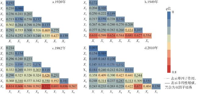
表1 不同时期平遥县乡村人口分布因子探测结果Tab.1 Factor detection results of rural population distribution in Pingyao County in different periods |
| 影响 因素 | 1920 | 1949 | 1982 | 2010 | |||||||
|---|---|---|---|---|---|---|---|---|---|---|---|
| q值 | 排序 | q值 | 排序 | q值 | 排序 | q值 | 排序 | ||||
| X1 | 0.192** | 3 | 0.172** | 4 | 0.214** | 4 | 0.093** | 7 | |||
| X2 | 0.086** | 7 | 0.108** | 6 | 0.134** | 7 | 0.089** | 8 | |||
| X3 | 0.202** | 2 | 0.189** | 3 | 0.233** | 3 | 0.108** | 5 | |||
| X4 | 0.137** | 5 | 0.146** | 5 | 0.174** | 6 | 0.103** | 6 | |||
| X5 | 0.021 | - | 0.057 | - | 0.045 | - | 0.022 | - | |||
| X6 | 0.133* | 6 | 0.110 | - | 0.118** | 8 | 0.131** | 4 | |||
| X7 | 0.275** | 1 | 0.208** | 2 | 0.251** | 2 | 0.344** | 1 | |||
| X8 | 0.139** | 4 | 0.107** | 7 | 0.181** | 5 | 0.151** | 2 | |||
| X9 | - | - | 0.554** | 1 | 0.567** | 1 | 0.150** | 3 | |||
注:**、*分别表示通过0.01和0.1的显著性检验,只对通过显著性检验的影响因素进行排序。 |
| [1] |
李智, 张小林, 李红波. 县域城乡聚落规模体系的演化特征及驱动机理:以江苏省张家港市为例[J]. 自然资源学报, 2019, 34(1):140-152.
|
| [2] |
刘彦随. 中国新时代城乡融合与乡村振兴[J]. 地理学报, 2018, 73(4):637-650.
|
| [3] |
新华社. 中共中央办公厅、国务院办公厅印发《关于推进以县城为重要载体的城镇化建设的意见》[EB/OL]. https://www.gov.cn/zhengce/2022-05/06/content_5688895.htm,2022-05-06.
|
| [4] |
胡焕庸. 中国人口之分布:附统计表与密度图[J]. 地理学报, 1935, 2(2):33-74.
|
| [5] |
邓羽, 刘盛和, 蔡建明, 等. 中国省际人口空间格局演化的分析方法与实证[J]. 地理学报, 2014, 69(10):1473-1486.
|
| [6] |
刘涛, 彭荣熙, 卓云霞, 等. 2000—2020年中国人口分布格局演变及影响因素[J]. 地理学报, 2022, 77(2):381-394.
|
| [7] |
尹旭, 魏慧, 李裕瑞, 等. 中国不同类型地区人口时空分异特征:基于“五普”至“七普”分县人口数据的分析[J]. 地理科学进展, 2023, 42(3):452-463.
|
| [8] |
尹旭, 王婧, 李裕瑞, 等. 中国乡镇人口分布时空变化及其影响因素[J]. 地理研究, 2022, 41(5):1245-1261.
|
| [9] |
刘子鑫, 殷江滨, 曹小曙, 等. 基于不同尺度的关天经济区人口格局时空变化特征与差异[J]. 人文地理, 2017, 32(1):123-131.
|
| [10] |
吕敏娟, 郭文炯. 资源型区域乡村聚落规模结构及空间分异动态[J]. 经济地理, 2016, 36(12):126-134.
|
| [11] |
罗庆, 王冰冰, 樊新生, 等. 山区县人口分布的时空特征及主要影响因素分析:以河南省嵩县为例[J]. 地理科学进展, 2020, 39(7):1073-1084.
|
| [12] |
杨慧敏, 许家伟, 李小建. 城镇化进程中平原农区县域人口分布变化特征及影响因素:以豫东平原柘城县为例[J]. 地理研究, 2023, 42(6):1528-1544.
|
| [13] |
屠爽爽, 周星颖, 龙花楼, 等. 乡村聚落空间演变和优化研究进展与展望[J]. 经济地理, 2019, 39(11):142-149.
|
| [14] |
王庆成. 晚清华北乡村:历史与规模[J]. 历史研究, 2007(2):78-87.
|
| [15] |
郝文军. 清代乡村聚落分布与人口规模的环境要素分析:以乾隆44年(1779)陵川县为例[J]. 西北大学学报(自然科学版), 2015, 45(2):308-312.
|
| [16] |
安介生, 李嘎, 姜建国. 介休历史乡土地理研究[M]. 北京: 中国社会科学出版社, 2016.
|
| [17] |
李小建, 许家伟, 海贝贝. 县域聚落分布格局演变分析:基于1929—2013年河南巩义的实证研究[J]. 地理学报, 2015, 70(12):1870-1883.
|
| [18] |
王婉婷, 乌敦, 苏力德, 等. 土默特平原聚落分布形态演变及其驱动因素分析(1934—2019)[J]. 历史地理研究, 2022(3):87-100.
|
| [19] |
李金铮. 传统与变迁:近代华北乡村的经济与社会[M]. 北京: 人民出版社, 2014.
|
| [20] |
平遥县地方志编纂委员会. 平遥县志(1997—2011)[M]. 北京: 中华书局, 2016.
|
| [21] |
[清] 王绶等著, 王夷典录疏. 平遥县志:康熙四十六年八卷本[M]. 太原: 山西经济出版社, 2008.
|
| [22] |
[清] 恩端. (光绪)平遥县志[M]. 南京: 凤凰出版社, 2005.
|
| [23] |
平遥县地方志编纂委员会. 平遥县志[M]. 北京: 中华书局,1999.
|
| [24] |
山西省地图集编纂委员会. 山西省地图集[M]. 太原: 山西人民出版社,1961.
|
| [25] |
黄娟, 李阳兵, 徐倩, 等. 岩溶槽谷区农村人口与耕地变化的时空耦合关系[J]. 水土保持研究, 2021, 28(3):281-290.
|
| [26] |
山西省人口普查办公室. 山西省第四次人口普查手工汇总资料·晋中分册[M]. 太原: 山西经济出版社,1991.
|
| [27] |
山西省人口普查办公室. 山西省2000年村、居委会人口资料[M]. 北京: 中国统计出版社, 2002.
|
| [28] |
晋中市第六次人口普查领导小组办公室,晋中市统计局. 晋中市2010年人口普查资料(上册)[M]. 北京: 中国统计出版社, 2012.
|
| [29] |
陈学兄, 常庆瑞, 毕如田, 等. 地形起伏度最佳统计单元算法的比较研究[J]. 水土保持研究, 2018, 25(1):52-56.
|
| [30] |
喻红, 曾辉, 江子瀛. 快速城市化地区景观组分在地形梯度上的分布特征研究[J]. 地理科学, 2001, 21(1):64-69.
|
| [31] |
段小薇, 李小建. 山区县域聚落演化的空间分异特征及其影响因素:以豫西山地嵩县为例[J]. 地理研究, 2018, 37(12):2459-2474.
|
| [32] |
|
| [33] |
叶浩, 庄大昌. 城市体系规模结构研究的新方法:位序累积规模模型[J]. 地理科学, 2017, 37(6):825-832.
|
| [34] |
|
| [35] |
娄帆, 李小建, 陈晓燕. 平原和山区县域聚落空间演变对比分析:以河南省延津县和宝丰县为例[J]. 经济地理, 2017, 37(4):158-166.
|
| [36] |
卫春江, 朱纪广, 李小建, 等. 传统农区村落位序—规模法则的实证研究:以周口市为例[J]. 经济地理, 2017, 37(3):158-165.
|
| [37] |
黄万状, 石培基. 河湟地区乡村聚落位序累积规模模型的实证研究[J]. 地理学报, 2021, 76(6):1489-1503.
|
| [38] |
刘振, 戚伟, 齐宏纲, 等. 1990—2015年中国县市尺度人口收缩的演变特征及影响因素[J]. 地理研究, 2020, 39(7):1565-1579.
|
| [39] |
王劲峰, 徐成东. 地理探测器:原理与展望[J]. 地理学报, 2017, 72(1):116-134.
|
| [40] |
金其铭. 农村聚落地理[M]. 北京: 科学出版社,1988.
|
| [41] |
李智, 张小林, 李红波, 等. 江苏典型县域城乡聚落规模体系的演化路径及驱动机制[J]. 地理学报, 2018, 73(12):2392-2408.
|
| [42] |
罗光杰, 李阳兵, 王世杰. 岩溶山区聚落格局演变等级效应及其与交通条件的关系:以贵州省后寨河、王家寨、茂兰地区为例[J]. 中国岩溶, 2011, 30(3):320-326.
|
| [43] |
杨忍, 邓颖贤. 广东省村镇聚落体系演化及其优化重组[J]. 地理学报, 2024, 79(2):281-298.
|
| [44] |
刘容亭. 山西阳曲等二十二县五十个乡村人口概况之调查[C]// 李文海.民国时期社会调查丛编·一编·人口卷(第2版). 福州: 福建教育出版社, 2014.
|
| [45] |
刘翠玲, 许亚平, 王法辉. 基于区域划分方法的1953—2010年中国人口分布格局及变化研究[J]. 地理学报
( 英文版), 2019,29(11 ) :1908-1922.
|
| [46] |
周成虎, 程维明, 钱金凯, 等. 中国陆地1∶100万数字地貌分类体系研究[J]. 地球信息科学学报, 2009, 11(6):707-724.
|
| [47] |
钟翀. 北江盆地:宗族、聚落的形态与发生史研究[M]. 北京: 商务印书馆, 2011.
|
/
| 〈 |
|
〉 |
