
多尺度旅游资源空间信息图谱构建——以海南岛为例
|
张桐艳(1987—),女,博士,讲师,研究方向为旅游资源评价与开发、旅游信息挖掘与可视化。E-mail:zhangtongyan@ouc.edu.cn |
收稿日期: 2024-07-18
修回日期: 2025-01-03
网络出版日期: 2025-05-12
基金资助
国家自然科学基金项目(42001243)
山东省自然科学基金项目(ZR2022QD132)
山东省社会科学规划项目(24DGLJ35)
教育部人文社会科学研究项目(24YJAZH226)
Multi-scale Tourism Resource Spatial Information Tupu: A Case Study of Hainan Island
Received date: 2024-07-18
Revised date: 2025-01-03
Online published: 2025-05-12
张桐艳 , 张生瑞 , 王英杰 , 虞虎 , 韩莹 . 多尺度旅游资源空间信息图谱构建——以海南岛为例[J]. 经济地理, 2025 , 45(2) : 236 -248 . DOI: 10.15957/j.cnki.jjdl.2025.02.023
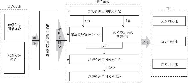
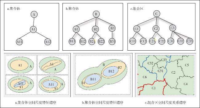
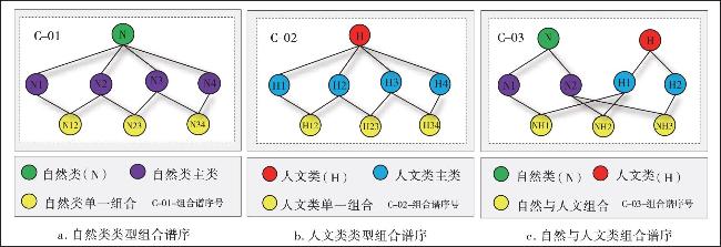
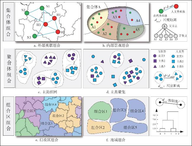
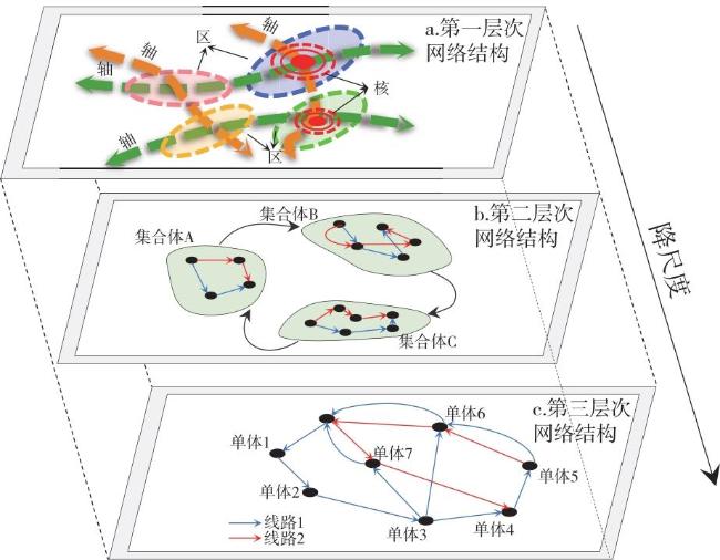
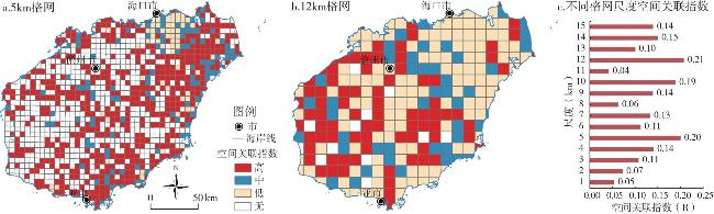
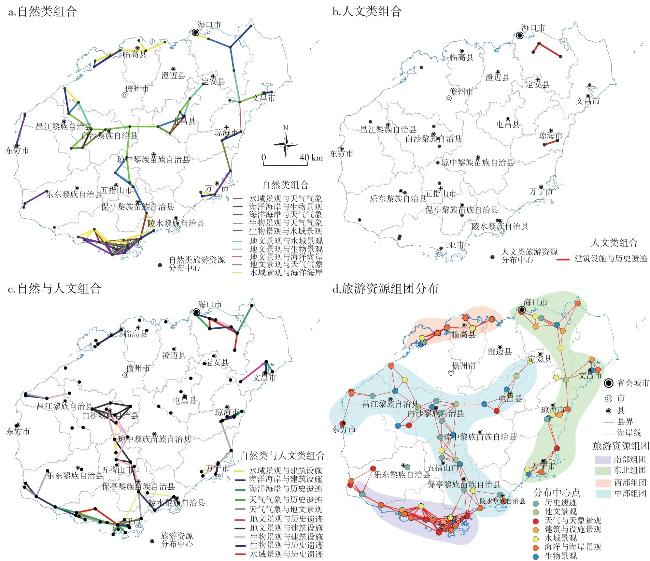
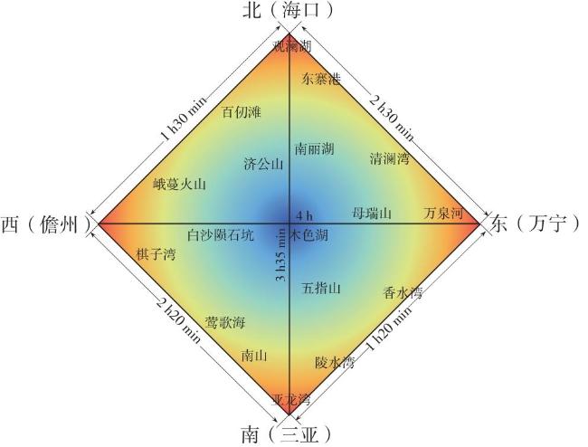
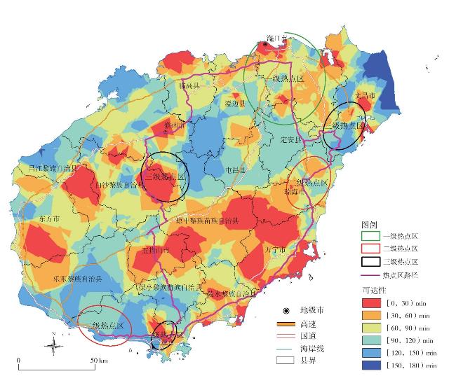
Based on the theory of geological information Tupu, this study defines the spatial units of tourism resources from a multi-scale perspective and constructs four types of spatial information Tupu for tourism resources at different scales: spatial scale, spatial correlation, spatial combination, and spatial structure. Taking Hainan Island as a case study for empirical analysis, it reveals the spatial variation patterns of multi-scale tourism destinations. It's found that: 1) The characteristic scales of all tourism resources and cultural tourism resources in Hainan Island are consistent, whereas natural tourism resources exhibit significant differences in characteristic scales. At the full-scale level, the characteristic scale for cultural tourism resources is 600 meters, whereas that of natural tourism resources is 14 kilometers. Additionally, the optimal scale for cities and counties is less than 2 kilometers. 2) Tourism resources exhibit distinct spatial correlation characteristics under various terrain conditions. It demonstrates stronger correlation in the eastern region of Hainan Island within a 5-kilometer range, while in the western region of Hainan Island, a stronger correlation is observed within a 12-kilometer range. 3) Based on characteristic scale, The combination of natural tourism resources with other type of tourism resources is relatively concentrated in the southern region, whereas the combination of cultural tourism resources with other type of tourism resources are sparsely distributed, mainly in the northern and eastern regions. The combination of natural tourism resources and cultural tourism resources is primarily concentrated in the southeastern, northern, and central regions. 4) As the spatial structure scale of tourism resources changes, the tourism spatial development in the future will also undergo corresponding transformations. The connectivity lines of the tourism resource complex within Hainan Island form a grid distribution pattern. The areas with the highest accessibility include the first-level hotspot area in Haikou, the second-level hotspot area in central Sanya, and the third-level hotspot area in Baisha. Future tourism spatial planning should emphasize the construction of east-west tourism routes. Moreover, based on transportation accessibility, tourism products of varying types should be designed to connect different categories of scenic spots.
表1 主要交通线路等级时间成本值Tab.1 Time cost values of major traffic route levels |
| 道路等级 | 高铁 | 铁路 | 高速公路 | 国道 | 省道 | 县道 | 空白区域 |
|---|---|---|---|---|---|---|---|
| 速度(km/h) | 200 | 120 | 120 | 80 | 60 | 40 | 5 |
| 时间成本(min/km) | 0.30 | 0.50 | 0.50 | 0.75 | 1.00 | 1.50 | 12.00 |
表2 不同类型旅游资源特征尺度Tab.2 Characteristic scale of different types of tourism resources |
| 面积(万km2) | 特征距离(km) | |||||||||
|---|---|---|---|---|---|---|---|---|---|---|
| 总体 | 自然 | 人文 | 地文景观 | 水域景观 | 天气与气候景观 | 生物景观 | 海洋与海岸景观 | 建筑与设施 | 历史遗迹 | |
| [3,3.4) | 0.60 | 14.29 | 0.60 | 33.79 | 4.43 | 2.38 | 1.19 | 12.75 | 28.97 | 0.60 |
| [2,3) | 0.50 | 3.97 | 0.52 | 18.45 | 0.85 | 2.55 | 1.04 | 11.49 | 18.34 | 0.52 |
| [1,2) | 0.39 | 0.41 | 0.41 | 7.02 | 0.41 | 2.02 | 0.65 | 5.01 | 4.55 | 0.41 |
| (0,1) | 0.22 | 0.24 | 0.24 | 0.24 | 0.24 | 0.59 | 0.24 | 1.80 | 1.04 | 0.24 |
表3 不同地形条件下不同类型旅游资源之间的关联规则Tab.3 Association rules between different types of tourism resources under different terrain conditions |
| 前项类型 | 前项属性(高程;坡度) | 后项 |
|---|---|---|
| 沟壑 与洞 穴 | [0,300)m;[5°,25°) | 历史事件发生地 |
| [0,600]m;[5°,25°) | 独树与丛树 | |
| [0,900)m;[5°,35°) | 游憩河段 | |
| [0,300)m、[600,900)m;[5°,25°) | 奇特与象形山石 | |
| [0,300)m;<5°、[5°,8°)、[15°,25°)、[25°,35°) | 军事遗址与古战场 | |
| [0,300)m、[600,1200]m;[25°,35°)、≥35° | 钙华与泉华 | |
| [0,300)m、[600,900]m;<5°、[8°,15°] | 瀑布 | |
| [0,300)m、[600,900]m;<5°、[8°,15°)、[15°,25°] | 史前人类活动遗址 | |
| 军事 遗址 与古 战场 | [0,600)m;[5°,8°)、[25°,35°) | 碑碣、碑林、经幢 |
| [0,900)m;[5°,25°] | 独树与丛树 | |
| [0,900)m;[5°,35°) | 游憩河段 | |
| [0,900)m;[5°,35°) | 林地 | |
| [0,600)m;[5°,8°)、[25°,35°) | 纪念地与纪念活动场所 | |
| 瀑布 | [0,1500)m;[5°,35°) | 沟谷型景观 |
| [0,1500)m;[5°,35°) | 游憩河段 | |
| [0,1500)m;[5°,35°) | 林地 | |
| [0,1500)m;[5°,35°) | 潭池 | |
| [0,1500)m;[5°,35°) | 史前人类活动遗址 | |
| [0,900)m;[5°,35°) | 陵墓 | |
| 宗教 与祭 祀活 动场 所 | [0,300)m;[5°,15°] | 沟壑与洞穴 |
| [0,300)m;[5°,8°) | 泉 | |
| [0,300)m;[5°,25°] | 塔式建筑 | |
| [0,600)m;[5°,25°] | 独树与丛树 | |
| [0,600)m;[5°,25°] | 军事遗址与古战场 | |
| [0,900)m;[5°,25°] | 游憩河段 | |
| [0,900)m;[5°,25°] | 林地 |
| [1] |
|
| [2] |
王朝辉. 产业融合拓展旅游发展空间的路径与策略[J]. 旅游学刊, 2011, 26(6):6-7.
|
| [3] |
任以胜, 陆林, 韩玉刚. 新旅游资源观视角下旅游资源研究框架[J]. 自然资源学报, 2022, 37(3):551-567.
|
| [4] |
郭来喜, 吴必虎, 刘锋, 等. 中国旅游资源分类系统与类型评价[J]. 地理学报, 2000, 55(3):294-301.
|
| [5] |
白凯, 王馨. 《旅游资源分类、调查与评价》国家标准的更新审视与研究展望[J]. 自然资源学报, 2020, 35 (7):1525-1540.
|
| [6] |
朱鹤, 高翔宇, 张生瑞, 等. 旅游资源区域组合:内涵、识别技术与关键问题[J]. 自然资源学报, 2024, 39 (7):1493-1511.
|
| [7] |
苗红, 张敏. 基于GIS缓冲区分析的西北民族地区“非遗”旅游资源空间结构研究[J]. 干旱区资源与环境, 2014, 28 (4):179-186.
|
| [8] |
李鹏, 王英杰, 虞虎, 等. 基于GIS格网化分析支撑的旅游空间规划技术方法研究——以青岛市为例[J]. 自然资源学报, 2018, 33 (5):813-827.
|
| [9] |
|
| [10] |
|
| [11] |
王雨青, 李玉凤, 徐薇, 等. 基于多尺度融合的旅游生态承载力评估[J]. 自然资源学报, 2024, 39(7):1575-1590.
|
| [12] |
陈佳淇, 王胜宏, 王圣斌, 等. 长征沿线红色旅游多尺度空间行为模式挖掘与仿真模拟[J]. 旅游学刊, 2024, 39(4):124-138.
|
| [13] |
|
| [14] |
张桐艳, 王英杰, 张生瑞, 等. 基于Voronoi模型的海南岛旅游资源集合体空间边界提取[J]. 地理学报, 2021, 76(6):1553-1569.
|
| [15] |
王英杰, 张桐艳, 李鹏, 等. GIS在中国旅游资源研究与应用中的现状及趋势[J]. 地球信息科学学报, 2020, 22(4):751-759.
|
| [16] |
齐清文. 地学信息图谱的最新进展[J]. 测绘科学, 2004, 29 (6):15-23,3.
|
| [17] |
张百平, 周成虎, 陈述彭. 中国山地垂直带信息图谱的探讨[J]. 地理学报, 2003, 58(2):163-171.
|
| [18] |
王志华, 杨晓梅, 周成虎. 面向遥感大数据的地学知识图谱构想[J]. 地球信息科学学报, 2021, 23(1):16-28.
|
| [19] |
胡最, 郑文武, 刘沛林, 等. 湖南省传统聚落景观基因组图谱的空间形态与结构特征[J]. 地理学报, 2018, 73(2):317-332.
|
| [20] |
王莹莹. 多尺度行政地名演变信息图谱构建与演变机制研究[D]. 北京: 中国科学院大学, 2020.
|
| [21] |
|
| [22] |
陈刚, 何政伟, 杨斌. 地形特征与山地气候变化空间关联规则数据挖掘研究[J]. 地理与地理信息科学, 2010, 26(1):37-40,47.
|
| [23] |
田至美, 文一惠. 天津市旅游资源的空间组合特征及其优化开发策略[J]. 资源与产业, 2010, 12(1):89-94.
|
| [24] |
王莹莹, 王英杰, 戈大专, 等. 典型贫困山区旅游景点可达性评价方法研究[J]. 地球信息科学学报, 2018, 20(7):957-966.
|
| [25] |
刘培学, 王欢颖, 陈伟, 等. 新冠疫情对旅游景区客源市场需求的空间分异影响——以南京夫子庙景区为例[J]. 地理科学, 2022, 42(7):1250-1259.
|
| [26] |
唐月亮, 段建南, 魏晓, 等. 中国旅游用地研究进展与启示[J]. 经济地理, 2021, 41(5):213-222.
|
| [27] |
张广海, 袁洪英, 段若曦, 等. 中国高等级旅游景区资源多尺度时空差异及其影响因素[J]. 自然资源学报, 2022, 37(10):2672-2687.
|
| [28] |
王迪, 钱海忠, 赵钰哲. 综述与展望:地理空间数据的管理、多尺度变换与表达[J]. 地球信息科学学报, 2022, 24(12):2265-2281.
|
| [29] |
蒋依依, 高洁, 郭佳明, 等. 地理大数据在旅游领域的创新应用及学科影响和研究展望[J]. 地球信息科学学报, 2024, 26(2):242-258.
|
/
| 〈 |
|
〉 |

