
低碳视角下长江经济带土地利用碳排放的空间分异
|
苑韶峰(1975—),男,山西繁峙人,博士,教授,博士生导师。主要研究方向为土地资源管理。E-mail:shaofengyuan1975@163.com。 |
收稿日期: 2018-05-04
修回日期: 2018-12-07
网络出版日期: 2025-04-27
基金资助
浙江省哲学社会科学规划基金项目(19NDJC015Z)
浙江省哲学社会科学规划基金项目(18NDJC196YB)
国家自然科学基金面上项目(41871181)
教育部人文社会科学规划基金项目(18YJA630136)
Spatial Differentiation of Land Use Carbon Emission in the Yangtze River Economic Belt Based on Low Carbon Perspective
Received date: 2018-05-04
Revised date: 2018-12-07
Online published: 2025-04-27
苑韶峰 , 唐奕钰 . 低碳视角下长江经济带土地利用碳排放的空间分异[J]. 经济地理, 2019 , 39(2) : 190 -198 . DOI: 10.15957/j.cnki.jjdl.2019.02.023
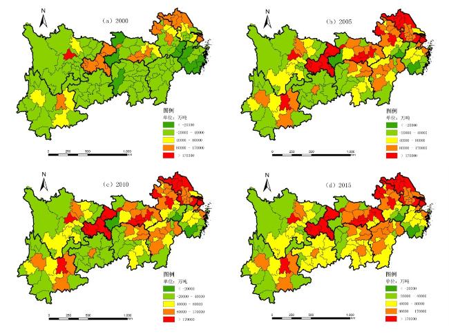
Taking the Yangtze River Economic Belt as the research object and based on the Landsat TM image interpretation data from the four periods of 2000-2015, this paper constructs a carbon emission model and analyzes the spatial and temporal differences of carbon emissions from the aspects of ecological carrying capacity, economic contribution and their coupling relationship. The results are as follows: 1) From 2000 to 2015, the regional carbon emissions of the Yangtze River Economic Belt have significant regional differences, and the carbon emissions of various cities have increased to various degrees, and the growth from the upstream to the downstream gradually increases. 2) The carbon emission of land use in the Yangtze River Economic Belt is generally positively correlated. Moran's I value decreases after increasing, positive correlation in the carbon emission intensity increases, the agglomeration state is significant and the heterogeneous spatial unit increases. The local spatial autocorrelation shows that the high value clustering center is located in the downstream coastal area and the low value is mainly distributed in the upstream and middle reaches. The lower value and higher value are distributed in the middle and lower reaches, respectively. 3) The economic contribution coefficient of carbon emission gradually reduces from the east of Yangtze River Economic Belt to the west. The ecological carrying capacity is higher in the east than the west and the lowest in the middle. Both of them show a rising trend in varying degrees, and the difference in coupling coordination is small. The difference between the middle and lower reaches is relatively larger. 4) In order to better realize the sustainable development of land use and promote the transformation of land use mode towards low-carbon and intensive development, the regulation of low-carbon land use can be carried out in different regions.
表1 长江经济带土地利用碳排放系数Tab.1 Carbon emission coefficient of land use in the Yangtze River Economic Belt |
| 地级市所在省份 | 耕地 | 林地 | 草地 | 水域 | 未利用地 | 煤炭 | |
|---|---|---|---|---|---|---|---|
| 上游 | 重庆、四川、云南、贵州 | 0.4689 | -0.6046 | -0.0206 | -0.2530 | -0.0028 | 0.7172 |
| 中游 | 江西、湖北、湖南 | 0.4970 | -0.6440 | -0.0200 | -0.0230 | -0.0050 | 0.7476 |
| 下游 | 上海、浙江、江苏、安徽 | 0.4220 | -0.6125 | -0.0210 | -0.0248 | -0.0005 | 0.7559 |
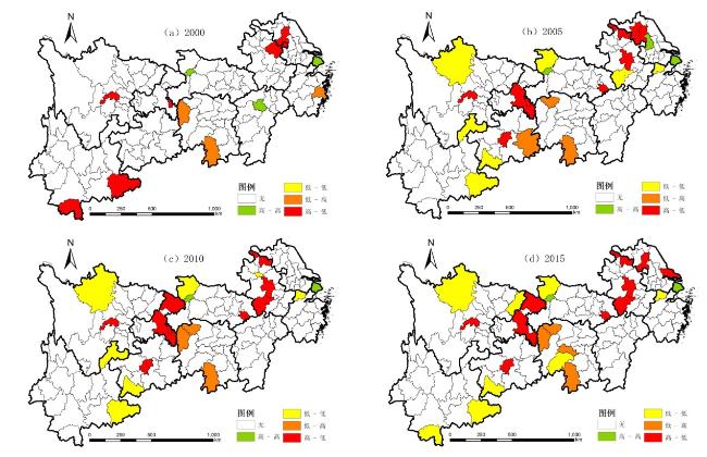
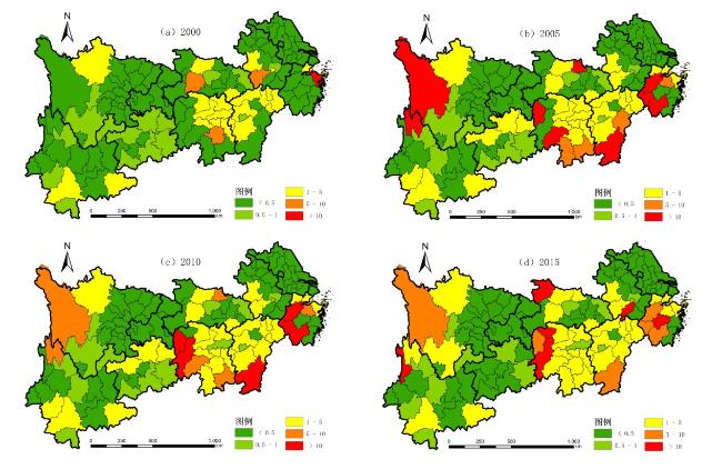
图3 长江经济带土地利用碳排放LISA图Fig.3 LISA diagram of land use carbon emissions in the Yangtze River Economic Belt |
表2 土地利用碳排放集聚中心和孤立点的空间转移路径Tab.2 Transfer path of spatial clusters and outliers for carbon emission on land use |
| 高—高(H-H) | 低—低(L-L) | 低—高(L-H) | 高—低(H-L) | |
|---|---|---|---|---|
| 2000 | 上海、南昌 | - | 台州、永州、湘西土家族苗族自治州 | 淮安、徐州、眉山、文山壮族苗族自治州、西双版纳傣族自治州 |
| 2005 | 上海、扬州 | 湖州、安庆、十堰、邵通、阿坝藏族羌族自治州、文山壮族苗族自治州、黔西南布依族苗族自治州 | 张家界、永州、黔东南苗族侗族自治州 | 淮安、宿迁、宿州、合肥、黄石、重庆、贵阳、眉山 |
| 2010 | 上海 | 湖州、淮南、十堰、邵通、阿坝藏族羌族自治州、文山壮族苗族自治州、黔西南布衣族苗族自治州 | 张家界、永州、湘西土家族苗族自治州 | 宿州、合肥、安庆、黄石、重庆、贵阳、眉山 |
| 2015 | 上海 | 湖州、邵阳、十堰、达州、阿坝藏族羌族自治州、黔西南布衣族苗族自治州、文山壮族苗族自治州、西双版纳傣族自治州 | 张家界、永州、娄底、湘西土家族苗族自治州 | 南通、淮安、宿州、合肥、安庆、黄石、重庆、眉山、贵阳 |
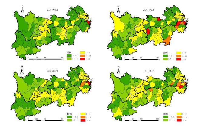
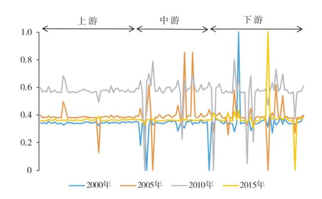
图4 长江经济带碳排放经济贡献系数空间分布Fig.4 Spatial distribution of economic compensation coefficient of carbon emission in Yangtze River Economic Belt |
| [1] |
沈永平, 王国亚. IPCC第一工作组第五次评估报告对全球气候变化认知的最新科学要点[J]. 冰川冻土, 2013, 35(5):1 068-1 076.
|
| [2] |
|
| [3] |
|
| [4] |
|
| [5] |
|
| [6] |
|
| [7] |
赵荣钦, 黄贤金, 揣小伟. 中国土地利用碳排放和研究误区和未来趋向[J]. 中国土地科学, 2016, 30(12):83-92.
|
| [8] |
方精云, 郭兆迪, 朴世龙, 等. 1981—2000年中国陆地植被碳汇的估算[J]. 中国科学:地球科学, 2007, 37(6):804-812.
|
| [9] |
王喜, 张艳, 秦耀辰, 等. 我国碳排放变化影响因素的时空分异与调控[J]. 经济地理, 2016, 36(8):158-165.
|
| [10] |
游和远, 吴次芳. 土地利用的碳排放效率及其低碳优化——基于能源消耗的视角[J]. 自然资源学报, 2010, 25(11):1 875-1 886.
|
| [11] |
黎孔清, 陈银蓉, 陈家荣. 基于ANP的城市土地低碳集约利用评价模型研究——以南京市为例[J]. 经济地理, 2013, 33(2):156-161.
|
| [12] |
张苗, 兰梦婷, 陈银蓉, 等. 国外土地利用与碳排放知识图谱分析——基于CiteSpace软件的计量分析[J]. 中国土地科学, 2017, 31(3):51-60.
|
| [13] |
姚姿臣. 区域经济发展方式转变进程评价及路径探索——基于长江经济带11省2003—2015年的经验数据[J]. 经济地理, 2018, 38(3):46-52.
|
| [14] |
|
| [15] |
朱巧娴, 梅昀, 陈银蓉, 等. 基于碳排放测算的湖北省土地利用结构效率的DEA模型分析与空间分异研究[J]. 经济地理, 2015, 35(12):176-184.
|
| [16] |
|
| [17] |
彭文甫, 周介铭, 徐新良, 等. 成都平原及其周边区域土地利用碳排放效应及空间格局[J]. 生态科学, 2017, 36(3):105-114.
|
| [18] |
李颖, 黄贤金, 甄峰. 江苏省区域不同土地利用方式的碳排放效应分析[J]. 农业工程学报, 2008, 24(S2):102-107.
|
| [19] |
苏雅丽, 张艳芳. 陕西省土地利用变化的碳排放效益研究[J]. 水土保持学报, 2011, 25(1):152-156.
|
| [20] |
石洪昕, 穆兴民, 张应龙, 等. 四川省广元市不同土地利用类型的碳排放效应研究[J]. 水土保持通报, 2012, 32(3):101-106.
|
| [21] |
郑欣, 程久苗, 郑硕. 基于土地利用结构变化的芜湖市碳排放及其影响因素研究[J]. 水土保持研究, 2012, 19(3):259-262,268.
|
| [22] |
赖力, 黄贤金, 刘伟良, 等. 基于投入产出技术的区域生态足迹调整分析——以2002年江苏省经济为例[J]. 生态学报, 2006(4):1 285-1 292.
|
| [23] |
段晓男, 王效科, 逯非, 等. 中国湿地生态系统固碳现状和潜力[J]. 生态学报, 2006, 28(2):463-469.
|
| [24] |
|
| [25] |
赵荣钦, 黄贤金. 基于能源消费的江苏省土地利用碳排放与碳足迹[J]. 地理研究, 2010, 29(9):1 639-1 649.
|
| [26] |
冯杰, 王涛. 中国土地利用碳排放演变与影响因素分析[J]. 软科学, 2016, 30(5):87-90.
|
| [27] |
王刚, 张华兵, 薛菲, 等. 成都市县域土地利用碳收支与经济发展关系研究[J]. 自然资源学报, 2017, 32(7):1 170-1 182.
|
| [28] |
佟昕. 中国区域碳排放差异分析及减排路径研究[D]. 沈阳: 东北大学, 2015.
|
| [29] |
崔维军, 李宗锴. 中国东、中、西地区碳排放空间差异测度及成因研究[J]. 工业技术经济, 2015, 34(6):51-58.
|
| [30] |
孙赫, 梁红梅, 常学礼, 等. 中国土地利用碳排放及其空间关联[J]. 经济地理, 2015, 35(3):154-162.
|
/
| 〈 |
|
〉 |