
基于AIS数据的海上丝绸之路船舶活动时空格局
|
邓昭(1991—),男,河北迁安人,博士研究生,研究方向为港口航运经济与区域发展。E-mail:dengzhao0521@163.com |
收稿日期: 2020-05-09
网络出版日期: 2025-04-25
基金资助
国家重点研发计划项目(2017YFC1405600)
国家重点研发计划项目(2016YFC1402700)
国家社会科学基金重大项目(13&ZD170)
国家社会科学基金重大项目(18ZDA207)
国家社会科学基金后期资助项目(19FZZB013)
Spatial-temporal Distribution Pattern of Ship Activity in Maritime Silk Road Based on AIS Data
Received date: 2020-05-09
Online published: 2025-04-25
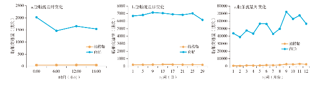
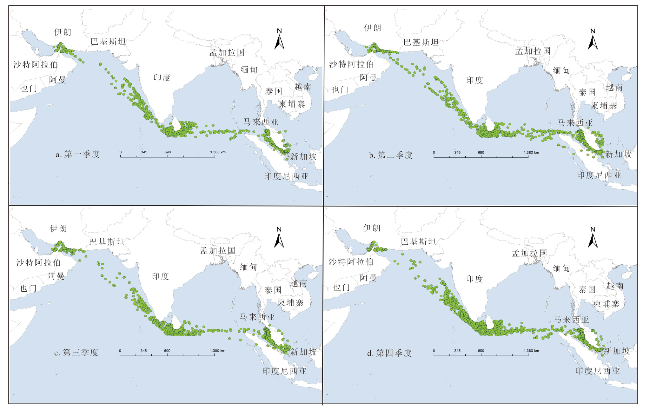
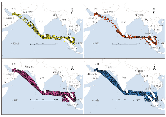
基于2018年海上丝绸之路船舶AIS数据和GIS空间分析工具,对船舶活动分布、尺度、速度等空间特征和船舶交通流日、月、季度变化等时间特征进行系统分析,结果显示:①捕捞船舶受时间、气候变化影响较大,白天时段及禁渔期结束至11月捕捞船活动较为频繁;商业船舶日、月度变化明显,季度变化不明显,午夜、中午、月度中下旬船舶活动较为频繁。②捕捞船多集中于近岸渔场及养殖区域,呈团状分布特征;商业船舶以油轮、货船为主,主要集中于新加坡—科伦坡—阿巴丹的主航道区。③各类型船舶以中小型为主,大型和巨型船舶比例较小。船舶航速以低速为主、中高速为辅,中高速船主要为货船和油轮,高速船舶以客船为主。④影响船舶活动时空变化特征的影响因素为地理条件与自然资源分布、经济发展与港口基础设施建设、海上交通管制等。
邓昭 , 李振福 , 段伟 , 李肇坤 . 基于AIS数据的海上丝绸之路船舶活动时空格局[J]. 经济地理, 2021 , 41(4) : 15 -22 . DOI: 10.15957/j.cnki.jjdl.2021.04.003
Based on the Automatic Identification System (AIS) data of ship in 2018 along the Maritime Silk Road,this study systematacially analyzes the spatio-temporal characteristics of ships from the activity trajectory distribution,ship size and speed,traffic flow of ship (daily,month and season) applying GIS spatial analysis. The results show: 1) Fishing vessels are greatly affected by time and climate changes,and the activities of fishing vessels are more frequent at day time and the time from the end of the fishing ban period to November; commercial vessels have significantly daily and monthly changes,and quarterly changes are not obvious. The activities of commercial vessels are more frequent at midnight,noon and mid-to-late month. 2) Fishing vessels are mostly concentrated in the near-shore fishing grounds and aquaculture areas,it presents a cluster distribution characteristic; commercial vessels are mainly oil tankers and cargo ships,and mainly distribute in the main channel area of Singapore-Colombo-Abadan. 3) All types of vessels are mainly small and medium-sized,and the proportion of large and huge vessels is small. The vessels are mainly at a low speed,supplemented by medium and high speed. Vessels working at a medium-high speed are mainly cargo ships and tankers,and high-speed vessels are mainly passenger ships. 4)The influencing factors of the temporal and spatial variation characteristics of vessel activities are geographical conditions and natural resource distribution,economic development and port infrastructure construction, marine traffic control and so on.
图2 海上丝绸之路捕捞船活动季度变化Fig.2 Quarterly variation of fishing vessel activity in Maritime Silk Road |
表1 海上丝绸之路船舶活动季度变化(艘次/h)Tab.1 Quarterly variation of ship activity in Maritime Silk Road(ships/h) |
| 类型 | 1~12月 | 一季度(1~3月) | 二季度(4~6月) | 三季度(7~9月) | 四季度(10~12月) | ||||||||
|---|---|---|---|---|---|---|---|---|---|---|---|---|---|
| 均值 | 均值 | 相对变化(%) | 均值 | 相对变化(%) | 均值 | 相对变化(%) | 均值 | 相对变化(%) | |||||
| 捕捞船 | 1 717 | 794 | -53.8 | 1 217 | -29.1 | 2 023 | 17.8 | 2 833 | 65.0 | ||||
| 客船 | 3 651 | 2 539 | -30.5 | 5 249 | 43.8 | 2 934 | -19.6 | 3 884 | 6.40 | ||||
| 货船 | 21 074 | 11 698 | -44.5 | 12 966 | -38.5 | 13 641 | -35.3 | 16 020 | -24.0 | ||||
| 油轮 | 28 533 | 23 394 | -18.0 | 26 822 | -6.0 | 30 540 | 7.0 | 33 376 | 17.0 | ||||
| 全部船舶 | 54 975 | 44 217 | -19.6 | 53 334 | -3.0 | 57 107 | 3.9 | 65 242 | 18.7 | ||||
表2 海上丝绸之路主要港口区域船舶密度(艘次/h)Tab.2 The density of the ship in main port of Maritime Silk Road (ships/h) |
| 均值 | 新加坡 | 迪拜 | 科伦坡 | 巴生 | 槟城 | 阿巴斯 | 伦格港 | |
|---|---|---|---|---|---|---|---|---|
| 捕捞船 | 94 | 1 996 | 529 | 463 | 495 | 1 072 | 149 | 72 |
| 客船 | 259 | 6 314 | 4 189 | 620 | 64 | 1 111 | 126 | 123 |
| 货船 | 773 | 16 349 | 15 784 | 7 967 | 3 346 | 4 330 | 2 673 | 2 614 |
| 油轮 | 1 070 | 20 899 | 14 182 | 4 843 | 4 183 | 2 277 | 2 743 | 3 684 |
| 全部船舶 | 1 929 | 43 890 | 34 684 | 13 893 | 8 088 | 8 790 | 6 632 | 5 524 |
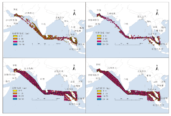
图4 海上丝绸之路各类船舶尺度分级Fig.4 The scale classification of all kinds of ships in Maritime Silk Road |
表3 海上丝绸之路各类船舶尺度统计Tab.3 The scale statistics of all kinds of ships in Maritime Silk Road |
| 船舶类型 | 船舶分类 | 小型 | 中型 | 大型 | 巨型 |
|---|---|---|---|---|---|
| 捕捞船 | 船长(m) | <22 | 22~43 | 43~78 | >78 |
| 占比(%) | 67.1 | 16.6 | 12.7 | 3.6 | |
| 客船 | 船长(m) | <55 | 55~125 | 125~225 | >225 |
| 占比(%) | 80.7 | 9.4 | 6.6 | 3.3 | |
| 货船 | 载重吨(万t) | <6 | 6~10 | 10~20 | >20 |
| 占比(%) | 70.2 | 16.2 | 11.8 | 1.8 | |
| 油轮 | 载重吨(万t) | <6 | 6~12 | 12~20 | >20 |
| 占比(%) | 65.5 | 16.2 | 4.9 | 13.4 |
图5 海上丝绸之路各类船舶速度分级Fig.5 The speed classification of all kinds of ships in Maritime Silk Road |
表4 海上丝绸之路船舶航速统计Tab.4 The speed statistics of all kinds of ships in Maritime Silk Road |
| 船舶类型 | 低速 (0~5 kn) | 中速 (5~10 kn) | 中高速 (10~20 kn) | 高速 (20~30 kn) |
|---|---|---|---|---|
| 捕捞船(%) | 79.2 | 17.7 | 3.0 | 0.1 |
| 客船(%) | 74.2 | 7.4 | 12.7 | 5.7 |
| 货船(%) | 52.3 | 8.7 | 38.0 | 0.9 |
| 油轮(%) | 64.3 | 7.2 | 28.4 | 0.1 |
| 全部船舶(%) | 60.8 | 8.1 | 30.2 | 0.8 |
| [1] |
|
| [2] |
潘家财, 邵哲平, 姜青山. 数据挖掘在海上交通特征分析中的应用研究[J]. 中国航海, 2010, 33(2):60-62,73.
|
| [3] |
金兴赋, 付玉慧, 张连东. 基于AIS数据的成山头水域船舶交通流研究[J]. 大连海事大学学报, 2012, 38(1):33-36.
|
| [4] |
刘虎, 李伟峰. 基于AIS数据的海上交通流区域自动识别[J]. 中国航海, 2016, 39(4):87-90,132.
|
| [5] |
|
| [6] |
|
| [7] |
|
| [8] |
|
| [9] |
|
| [10] |
|
| [11] |
|
| [12] |
潘晋, 汪咏, 黄义飞, 等. 基于AIS数据的船桥碰撞概率评估方法研究[J]. 华中科技大学学报:自然科学版, 2019, 47(11):109-114.
|
| [13] |
|
| [14] |
|
| [15] |
|
| [16] |
徐力, 项鹭, 柴田, 等. 厦门港航道通过能力建模及应用[J]. 中国航海, 2019, 42(2):32-36.
|
| [17] |
姚海元, 黄俊, 齐越, 等. AIS数据在航道通过能力提升中的仿真应用[J]. 系统工程, 2018, 36(10):125-136.
|
| [18] |
唐皇, 魏立桥, 尹勇, 等. 基于概率有向图模型的船舶进出港航路规划[J]. 华中科技大学学报:自然科学版, 2020, 48(5):105-109.
|
| [19] |
邢辉, 段树林, 黄连忠, 等. 基于AIS数据的渤海湾地区海运排放测算[J]. 中国环境科学, 2016, 36(3):953-960.
|
| [20] |
朱倩茹, 廖程浩, 王龙, 等. 基于AIS数据的精细化船舶排放清单方法[J]. 中国环境科学, 2017, 37(12):4493-4500.
|
/
| 〈 |
|
〉 |