
城乡景观复杂度视角下的城乡交错带界限确定——以武汉市为例
|
黄琦(1986—),男,湖北安陆人,博士研究生。主要研究方向为土地利用与信息管理。E-mail:397730973@qq.com。 |
收稿日期: 2019-06-09
修回日期: 2019-09-02
网络出版日期: 2025-04-18
基金资助
国家自然科学基金项目(41601166)
中央高校基本科研业务费专项资金项目(CCNU16A05056)
The Determination of Urban-Rural Ecotones from the Perspective of Urban and Rural Landscape Complexity
Received date: 2019-06-09
Revised date: 2019-09-02
Online published: 2025-04-18
黄琦 , 王宏志 , 顾江 , 曾菊新 . 城乡景观复杂度视角下的城乡交错带界限确定——以武汉市为例[J]. 经济地理, 2019 , 39(10) : 71 -77 . DOI: 10.15957/j.cnki.jjdl.2019.10.010
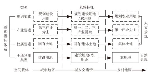
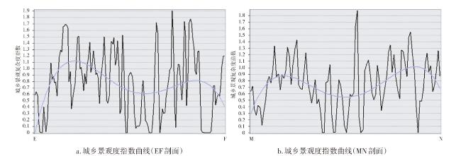
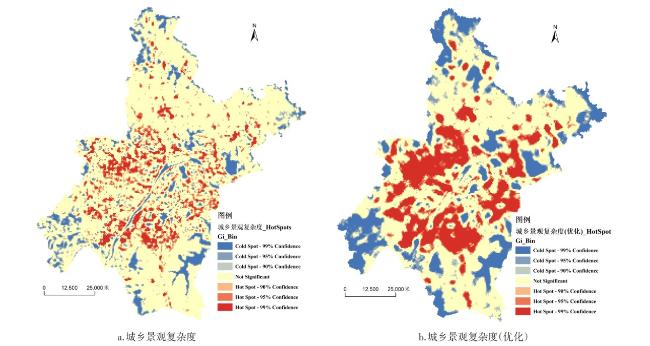
Urban-rural ecotones has become an independent regional unit that can not be ignored. But the method to determine its boundary still need to be developed. The higher the urban-rural landscape complexity index is, the closer the region is to Urban-rural ecotones. Based on the urban-rural landscape complexity, the boundaries of Urban-rural ecotones can be identified. Urban-rural ecotones is a transitional transformation area of urban-rural attributes, in which many elements are "staggered", and the complexity of urban-rural landscape is higher than that of urban central area and remote rural area. From the perspective of urban and rural landscape complexity, this paper first constructs a spatial element system of urban and rural attributes including land use status, ownership, industry and land planning. Then, using landscape complexity index, based on G-statistics, it determines that urban and rural landscape high-value concentration areas in urban and rural areas are the spatial boundaries of Urban-rural ecotones. Finally, the spatial boundaries of Urban-rural ecotones in Wuhan City are given. Presented in space. The results show that: 1) the complexity of urban and rural landscape presents a "M" distribution between urban and rural areas, and the landscape complexity of Urban-rural ecotones is the highest; 2) G-statistics confirms that the high-value agglomeration area of urban and rural landscape complexity is Urban-rural ecotones with high spatial boundaries. 3) Urban-rural ecotones is a collection of urban-rural attribute elements including natural and human factors; 4) Spatial function of Urban-rural ecotones should be brought into full play to promote urban-rural integration. The research methods in this paper are innovative, and the conclusions can provide reference for precise prevention and resolution of major risks in Urban-rural ecotones of key regions.
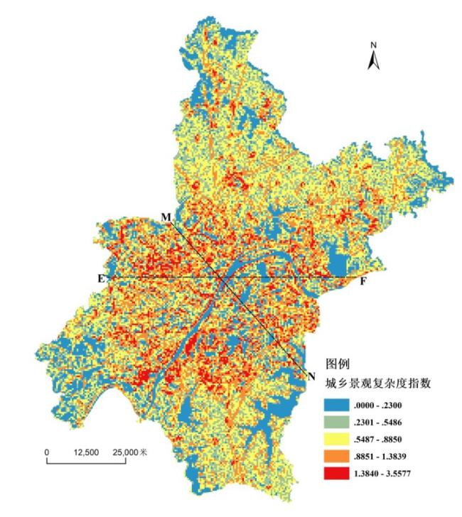
表1 武汉市城乡交错带空间界限描述Tab.1 Description of spatial boundaries of Urban-rural ecotones in Wuhan |
| 行政辖区 | 热点 | 主导区 | 城乡交错带空间界限描述 |
|---|---|---|---|
| 黄陂区 | G1 | 木兰文化生态旅游区 | 位于新城区。该片区包括木兰山、木兰天池、木兰草原、木兰云雾山、锦里沟、木兰古门、农耕年华、木兰湖、木兰玫瑰花园、木兰三台山、木兰花海乐园、木兰花乡等风景名胜区域,属武汉市旅游发展重点区域 |
| G2 | 前川街片区 | 位于新城区。黄陂区政府驻地,该片区主要包括前川街城关镇区域 | |
| G3 | 天河街片区 | 位于新城区。武汉天河机场所在地,依托机场发展临空产业 | |
| G4 | 盘龙城经济技术开发区 | 位于新城区。省级经济开发区 | |
| G5 | 王家河街片区 | 位于新城区。王家河街城关镇区域 | |
| 新洲区 | G6 | 道观河风景旅游区 | 位于新城区。位于新洲区东部 |
| G7 | 阳逻经济开发区 | 位于新城区。该片区包括阳逻街和双柳街区域 | |
| G8 | 邾城街片区 | 位于新城区。新洲区政府驻地,城关镇区域 | |
| 江岸区 | G9 | 谌家矶片区 | 位于中心城区。武汉市长江新城建设核心区域 |
| 硚口区 | G10 | 长丰街片区 | 位于中心城区。该片区包含易家街、长丰街,存在大量棚户区待拆迁 |
| 东西湖区 | G11 | 吴家山街片区 | 位于新城区。该片区包含吴家山街(区政府驻地),还包括长青街办、慈惠街办、径河街工业倍增区,是东西湖区工矿企业主要集聚区域 |
| 蔡甸区 | G12 | 蔡甸街片区 | 位于新城区。蔡甸区政府驻地,该片区主要包含城关镇区域 |
| G13 | 大集街片区 | 位于新城区。该片区包含中法生态新城、后官湖生态区、大集街区域 | |
| 武汉经济技术开发区 | G14 | 武汉经济技术开发区 | 位于新城区。该片区包含沌阳街道、沌口街道和军山街道,属于国家级经济技术开发区,主导产业为汽车,机械等制造业 |
| 东湖新技术开发区 | G15 | 东湖新技术开发区 | 位于新城区。该片区包含关东、佛祖岭、流芳、滨湖、九峰、花山、豹澥和左岭区域,主要产业为芯片、计算机、AI等高科技产业 |
| 江夏区 | G16 | 纸坊街片区 | 位于新城区。该片区包含大桥新区(江夏区政府驻地)、庙山、藏龙岛、纸坊街区域 |
| G17 | 乌龙泉街片区 | 位于新城区。该片区包含乌龙泉街城关镇以及沿107省道区域 |
| [1] |
|
| [2] |
张富刚, 刘彦随. 中国区域农村发展动力机制及其发展模式[J]. 地理学报, 2008, 63(2):115-122.
|
| [3] |
余强毅, 陈佑启, 许新国. 土地利用科学中的“城乡交错带”概念辨析[J]. 中国土地科学, 2010, 24(8):46-51.
|
| [4] |
|
| [5] |
|
| [6] |
周浩, 雷国平, 张红梅, 等. 土地利用空间关联下城乡结合部边界界定方法研究[J]. 中国土地科学, 2016, 30(6):81-88.
|
| [7] |
刘彦随, 严镔, 王艳飞. 新时期中国城乡发展的主要问题与转型对策[J]. 经济地理, 2016, 36(7):1-8.
|
| [8] |
马历, 龙花楼, 戈大专, 等. 中国农区城乡协同发展与乡村振兴途径[J]. 经济地理, 2018, 38(4):37-44.
|
| [9] |
赵华甫, 朱玉环, 吴克宁, 等. 基于动态指标的城乡交错带边界界定方法研究[J]. 中国土地科学, 2012, 26(9):60-65.
|
| [10] |
乔家君, 马玉玲. 基于信息熵的城乡界面时空演化与分异——以河南省巩义市为例[J]. 经济地理, 2016, 36(11):1-7.
|
| [11] |
顾朝林, 陈田, 丁金宏, 等. 中国大城市边缘区特性研究[J]. 地理学报, 1993(4):317-328.
|
| [12] |
李世峰. 大城市边缘区地域特征属性界定方法[J]. 经济地理, 2006(3):478-481,486.
|
| [13] |
章文波, 方修琦, 张兰生. 利用遥感影像划分城乡过渡带方法的研究[J]. 遥感学报, 1999, 3(3):199-202.
|
| [14] |
郭爱请, 葛京凤, 梁彦庆. 城乡结合部土地估价探讨——以石家庄市为例[J]. 资源科学, 2004(1):9-13.
|
| [15] |
陈佑启. 北京城乡交错带土地利用问题与对策研究[J]. 经济地理, 1996, 16(4):46-50,40.
|
| [16] |
王媛, 姜博, 初楠臣, 等. 基于建设用地变化的城市边缘区提取方法与扩张模式研究——以哈尔滨市为例[J]. 经济地理, 2016, 36(5):26-32.
|
| [17] |
钱建平, 周勇, 杨信廷. 基于遥感和信息熵的城乡结合部范围界定——以荆州市为例[J]. 长江流域资源与环境, 2007(4):451-455.
|
| [18] |
程连生, 赵红英. 北京城市边缘带探讨[J]. 北京师范大学学报:自然科学版, 1995(1):127-133.
|
| [19] |
黄海妮, 童新华, 罗国玮. 南宁市城郊结合部地域范围界定研究[J]. 广西师范学院学报:自然科学版, 2008(2):64-67.
|
| [20] |
阳文锐. 北京城市景观格局时空变化及驱动力[J]. 生态学报, 2015, 35(13):4 357-4 366.
|
| [21] |
石龙宇, 赵会兵, 郑拴宁, 等. 城乡交错带景感生态规划的基本思路与实现[J]. 生态学报, 2017, 37(6):2 126-2 133.
|
| [22] |
岳文泽, 徐建华, 谈文琦, 等. 城市景观多样性的空间尺度分析——以上海市外环线以内区域为例[J]. 生态学报, 2005, 25(1):122-128.
|
| [23] |
|
| [24] |
陈晓军, 张洪业, 刘盛和. 北京城市边缘区土地用途转换宏观动因机制研究[J]. 地理科学进展, 2003, 22(2):149-157.
|
| [25] |
刘吉平, 赵丹丹, 田学智, 等. 1954—2010年三江平原土地利用景观格局动态变化及驱动力[J]. 生态学报, 2014, 34(12):3 234-3 244.
|
| [26] |
|
| [27] |
|
| [28] |
吕立刚, 隋雪艳, 汪翔, 等. 江苏省土地城镇化的空间分异及其主导因素探测[J]. 人文地理, 2018, 33(4):88-94,112.
|
/
| 〈 |
|
〉 |
