
山地都市边缘区农村居民点布局优化策略——以重庆渝北区石船镇为例
|
王兆林(1979—),男,山东沂南人,博士,副教授,副研究员,硕士生导师。主要研究方向为土地资源管理。E-mail:wzhaolin@163.com。 |
收稿日期: 2018-12-24
修回日期: 2019-04-29
网络出版日期: 2025-04-17
基金资助
国土资源部公益项目(201311006)
国家社会科学基金项目(14CJY043)
重庆市社会科学规划项目(2017YBGL161)
重庆市社会科学规划项目(2018YBJJ027)
2018年国家留学基金委西部地区人才培养特别项目([2018]10006)
Optimization Strategy of Rural Settlement Layout in Mountainous Urban Fringe Area:A Case Study of Shichuan Town in Yubei District of Chongqing
Received date: 2018-12-24
Revised date: 2019-04-29
Online published: 2025-04-17
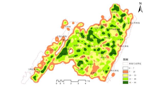
山地都市边缘区农村居民点因受自然条件及人类活动的双重扰动而深刻转型,探索特殊区域农村居民点布局适宜性及其优化策略,有利于推进特殊区域的国土空间治理与缓解用地矛盾,并为特殊地域的国土空间规划提供借鉴。文章以山地都市边缘区的重庆渝北区石船镇为例,采用地类转移矩阵、ArcGIS空间统计、理想点逼近(TOPSIS)、核密度法和多因素叠加分析等方法集成分析山地都市边缘区农村居民点优化布局与优化策略。结果表明:①研究区2010—2016年城镇建设用地单项动态度为55.72%,城镇建设用地需求旺盛,以耕地占用的发展模式,没有得到根本扭转,亟待通过居民点空间治理,增加建设用地指标,缓解用地矛盾。②研究区农村居民点总体分布零乱,但其内部空间布局在某种程度上仍表现出一定的空间集聚性,整体呈现出以河水村为中心,密度由内到外依次降低的规律。③研究区居民点布局受到自然、经济、社会多重因素影响,亟待因地制宜制定差异化的优化策略。
王兆林 , 杨庆媛 , 李计 , 王轶 , 鄂施璇 , 阳华 , 孙思睿 . 山地都市边缘区农村居民点布局优化策略——以重庆渝北区石船镇为例[J]. 经济地理, 2019 , 39(9) : 182 -190 . DOI: 10.15957/j.cnki.jjdl.2019.09.022
Rural settlement in mountainous urban fringe areas are undergoing profound transformation due to the dual disturbance of natural conditions and human activities. Therefore, exploring the suitability and optimization strategies of the rural settlement layout in special regions is conducive to promoting the spatial governance of special regions and alleviating land use contradictions. The paper takes Shichuan Town located at mountainous urban fringe area of Yubei District as an example, and adopts the methods of the transfer matrix, Arc GIS spatial statistical analysis, TOPSIS, kernel density analysis and multi-factor analysis to intensively analyze the optimization layout and strategies of the rural settlements on the mountainous urban fringe areas. The results show that: 1) The single dynamic degree of urban construction land is 55.72% from 2010 to 2016. The demand for urban construction land is strong, and the development pattern of cultivated land has not been radically reversed. It is urgent to alleviate the land use contradiction by the means of the spatial governance of rural settlement and the increase of the construction land index. 2) The overall distribution of rural settlements on the mountainous urban fringe area is disorderly and shows a decrease tendency with Heshui Village as the center, but it still represents spatial agglomeration in term of the internal spatial layout. 3)Rural settlement layout is influenced by multiple factors, such as natural, economic and social factors. Based on planning policy guidance and rural settlements space expansion restricted zoning,it should establish differentiated optimization strategies.
表1 土地利用转移矩阵表Tab.1 Transfer matrix of land use |
| 类型 | 总计 | 减少 | |||||
|---|---|---|---|---|---|---|---|
| … | |||||||
| … | |||||||
| … | |||||||
| … | … | … | … | … | … | … | |
| … | |||||||
| 总计 | … | 1 | |||||
| 新增 | … | 0 | |||||
表2 山地都市边缘区农村居民点布局适宜性评价指标体系Tab.2 Evaluation index system of settlement layout suitability in mountainous urban fringe area |
| 因素层 | 指标层 | 代码 | 各因子适宜性等级分值标准划分 | 权重 | |||
|---|---|---|---|---|---|---|---|
| 4 | 3 | 2 | 1 | ||||
| 自然禀赋因素 | 高程(m) | [0,300] | (300,500] | (500,800] | (800,+∞) | 0.092 | |
| 坡度(°) | [0,8] | (8,15] | (15,25] | (25,+∞) | 0.089 | ||
| 地质灾害 | 低易发区 | 中易发区 | 高易发区 | 极易发区 | 0.051 | ||
| 生活生产因素 | 距河流水库(m) | [0,500] | (500,1 000] | (1 000,2 000] | (200,+∞) | 0.227 | |
| 距离建制镇(m) | [0,500] | (500,1 500] | (1 500,2 500] | (2 500,+∞) | 0.143 | ||
| 距离机耕道(m) | [0,300] | (300,800] | (800,1 500] | (1 500,+∞) | 0.173 | ||
| 距最近耕地(m) | [0,500] | (500,1 000] | (1 000,1 500] | (1 500,+∞) | 0.012 | ||
| 居民点斑块因素 | 居民点分维数 A为斑块面积,P为斑块周长,反映图斑规则复杂程度。 | [0,1] | (1,2] | (2,3] | (3,+∞) | 0.091 | |
| 居民点斑块形状指数() E指斑块的边缘总长度,minE是E的最小可能值,反映斑块聚集或离散程度。 | [0,1] | (1,5] | (5,10] | (10,+∞) | 0.122 | ||
注:AHP确定指标权重,采用软件Yaahp 10.3计算。 |
表3 山地都市边缘区农村居民点优化布局适宜性等级标准Tab.3 Suitability rank of rural settlement optimum layout in mountainous urban fringe area |
| 贴近度 | 适宜性等级 |
|---|---|
| (0.8,1] | 最适宜 |
| (0.6,0.8] | 高度适宜 |
| (0.4,0.6] | 中度适宜 |
| (0.2,0.4] | 低度适宜 |
| [0,0.2] | 不适宜 |
表4 2010—2016年渝北区石船镇地类转移矩阵(单位:%)Tab.4 Transfer matrix of land type in Shichuan Town from 2010 to 2016 |
| 类别 | 2016年 | 总计 | 减少 | |||||||
|---|---|---|---|---|---|---|---|---|---|---|
| 城镇建设用地 | 农村居民点 | 交通运输用地 | 水域及水利设施用地 | 耕地 | 其他农用地 | 其他土地 | ||||
| 2010年 | 城镇建设用地 | 5.11 | 0 | 0 | 0 | 0 | 0 | 0 | 5.11 | 0 |
| 农村居民点 | 0.31 | 5.14 | 0 | 0 | 2.57 | 0.42 | 0 | 8.44 | 3.3 | |
| 交通运输用地 | 0 | 0 | 0.11 | 0 | 0 | 0 | 0 | 0.11 | 0 | |
| 水域及水利设施用地 | 0 | 0 | 0 | 0.31 | 0 | 0 | 0 | 0.31 | 0 | |
| 耕地 | 5.15 | 0.02 | 0.03 | 0.03 | 44.6 | 0.11 | 0.04 | 49.98 | 5.38 | |
| 其他农用地 | 0.97 | 0.06 | 0.02 | 0 | 0 | 32.91 | 0.05 | 34.01 | 1.1 | |
| 其他土地 | 0 | 0 | 0 | 0 | 0 | 0 | 2.04 | 2.04 | 0 | |
| 总计 | 11.54 | 5.22 | 0.16 | 0.34 | 47.17 | 33.44 | 2.13 | 100 | ||
| 新增 | 6.43 | 0.08 | 0.05 | 0.03 | 2.57 | 0.53 | 0.09 | 0 | ||
表5 2010—2016年石船镇地类变化量及其动态度(单位:%)Tab.5 Transfer matrix of land type in Shichuan Town and its dynamic degree in 2010-2016 |
| 地类 | 新增量 | 减少量 | 总变化量 | 交换变化量 | 净变化量 | 单项地类动态度 |
|---|---|---|---|---|---|---|
| 城镇建设用地 | 6.43 | 0 | 6.43 | 0 | 6.43 | 55.72 |
| 农村居民点 | 0.08 | 3.3 | 3.38 | 0.16 | 3.22 | 39.67 |
| 交通运输用地 | 0.05 | 0 | 0.05 | 0 | 0.05 | 31.25 |
| 水域及水利设施用地 | 0.03 | 0 | 0.03 | 0 | 0.03 | 8.82 |
| 耕地 | 2.57 | 5.38 | 7.95 | 5.14 | 2.81 | 15.13 |
| 其他农用地 | 0.53 | 1.1 | 1.63 | 1.06 | 0.57 | 4.72 |
| 其他土地 | 0.09 | 0 | 0.09 | 0 | 0.09 | 4.23 |
| 总计 | 9.78 | 9.78 | 19.56 | 6.36 | 13.2 |
表6 评价指标理想解Tab.6 Ideal solution of evaluation index |
| 类别 | |||||||||
|---|---|---|---|---|---|---|---|---|---|
| 0.0133 | 0.0527 | 0.0062 | 0.3011 | 0.0791 | 0.0411 | 0.0153 | 0.4026 | 0.0215 | |
| 0 | 0 | 0 | 0 | 0 | 0 | 0 | 0 | 0 |
表7 评价单元相对接近度Tab.7 Relative proximity of evaluation unit |
| 评价单元 | 适宜等级 | |||
|---|---|---|---|---|
| 1 | 0.0123 | 0.6131 | 0.9803 | 最适宜 |
| 2 | 0.1312 | 0.6521 | 0.8325 | 最适宜 |
| 3 | 0.1076 | 0.1342 | 0.5550 | 中度适宜 |
| … | … | … | … | … |
| 4 269 | 0.2346 | 0.3141 | 0.5724 | 中度适宜 |
| 4 270 | 0.2172 | 0.1126 | 0.3414 | 低度适宜 |
| 4 271 | 0.4015 | 0.3531 | 0.4679 | 中度适宜 |
| 4 272 | 0.3147 | 0.4642 | 0.5960 | 中度适宜 |
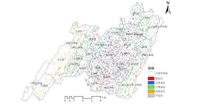
图2 石船镇农村居民点布局适宜性评价图Fig.2 Evaluation results of rural residential suitability in Shichuan Town |
表8 石船镇农村居民点布局适宜性评价结果表Tab.8 Results of suitability of rural settlements in Shichuan Town |
| 分级规则 | 适宜性等级 | 斑块个数(个) | 农村居民点面积(hm2) | 斑块个数比例(%) | 居民点面积比(%) |
|---|---|---|---|---|---|
| (0.8,1] | 最适宜 | 1 359 | 106.89 | 31.81 | 10.31 |
| (0.6,0.8] | 高度适宜 | 1 292 | 253.62 | 30.24 | 25.00 |
| (0.4,0.6] | 中度适宜 | 1 082 | 282.19 | 25.32 | 27.37 |
| (0.2,0.4] | 低度适宜 | 196 | 169.54 | 4.59 | 16.41 |
| [0,0.2] | 不适宜 | 343 | 214.71 | 8.04 | 20.91 |
| [1] |
|
| [2] |
|
| [3] |
|
| [4] |
|
| [5] |
|
| [6] |
|
| [7] |
宿瑞, 王成. 基于网络中心点辐射导向的农村居民点体系重组与优化——以重庆市江津区燕坝村为例[J]. 资源科学, 2018, 40(5):958-966.
|
| [8] |
孔雪松, 金璐璐, 郄昱, 等. 基于点轴理论的农村居民点布局优化[J]. 农业工程学报, 2014, 30(8):192-200.
|
| [9] |
冯电军, 沈陈华. 基于扩展断裂点模型的农村居民点整理布局优化[J]. 农业工程学报, 2014, 30(8):201-209.
|
| [10] |
李卫民, 李同昇, 武鹏. 基于引力模型与加权Voronoi图的农村居民点布局优化——以西安市相桥街道为例[J]. 中国农业资源与区划, 2018, 39(1):77-82.
|
| [11] |
张颖, 徐辉. 基于MCR模型的农村居民点布局适宜性分区及优化模式研究——以南京市六合区金牛湖街道为例[J]. 长江流域资源与环境, 2014, 23(11):1 485-1 492.
|
| [12] |
乔伟峰, 吴江国, 张小林, 等. 基于耕作半径分析的县域农村居民点空间布局优化——以安徽省埇桥区为例[J]. 长江流域资源与环境, 2013, 22(12):1 557-1 563.
|
| [13] |
谢炳庚, 曾晓妹, 李晓青, 等. 乡镇土地利用规划中农村居民点用地空间布局优化研究——以衡南县廖田镇为例[J]. 经济地理, 2010, 30(10):1 700-1 705.
|
| [14] |
匡垚瑶, 杨庆媛, 王兆林, 等. 低山丘陵区城乡结合部农村居民点布局优化——以重庆市渝北区古路镇为例[J]. 山地学报, 2017, 35(3):399-411.
|
| [15] |
刘瑞, 朱道林. 基于转移矩阵的土地利用变化信息挖掘方法探讨[J]. 资源科学, 2010, 32(8):1 544-1 550.
|
| [16] |
|
| [17] |
信桂新, 杨朝现, 杨庆媛, 等. 用熵权法和改进TOPSIS模型评价高标准基本农田建设后效应[J]. 农业工程学报, 2017, 33(1):238-249.
|
| [18] |
雷勋平,
|
/
| 〈 |
|
〉 |