
快速城市化下的武汉城市暴雨渍水空间特征及发生机制
|
陈昆仑(1982—),男,湖北荆门人,博士,教授,博士生导师。主要研究方向为城市地理与城市规划、体育地理。E-mail:ckl_2001@163.com。 |
收稿日期: 2019-11-21
修回日期: 2020-03-28
网络出版日期: 2025-04-17
基金资助
中央高校基本科研业务费专项资金资助项目(CUG2018123)
国家自然科学基金项目(41401181)
The Spatial Characteristics and Formation Mechanism of Urban Rainstorm Waterlogging under the Influence of Human Activities in Wuhan
Received date: 2019-11-21
Revised date: 2020-03-28
Online published: 2025-04-17
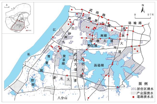
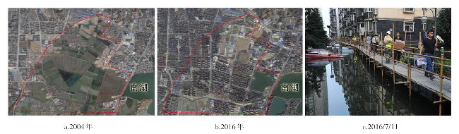
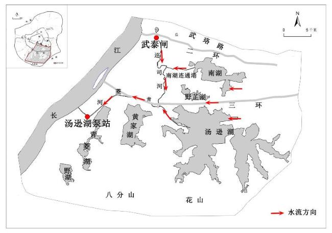
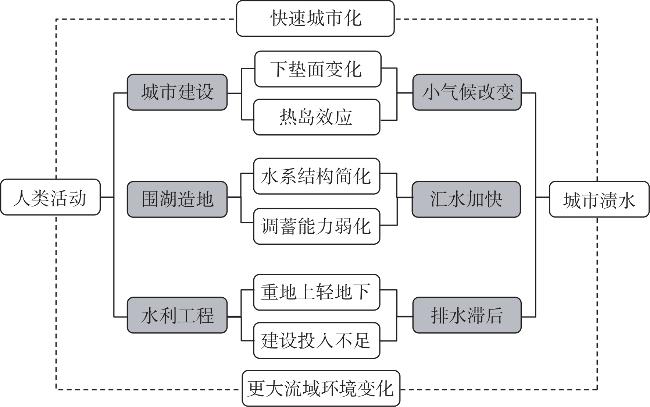
随着城市化进程的加快和社会经济的发展,城市内涝已成为继人口拥挤、交通拥堵、环境污染等问题之后的又一大城市病。武汉是我国内涝频发的城市之一,尤其是2016年夏季发生的城市内涝造成了巨大的社会经济损失。文章以武汉中心城区汤逊湖水系为研究范围,利用最邻近指数法、核密度强度分析法、湖泊变化强度指数等方法,探讨2016年6月30日—7月6日期间城市内涝灾害发生最严重时段的渍水特征,并揭示其形成原因和发生机制。研究发现:①城市暴雨渍水类型多样,主要包括居住区渍水、道路渍水和产业园区渍水三类。②渍水点呈现明显的空间集聚特征:渍水点以湖泊为中心集中分布,围湖造地区域是渍水发生的重灾区,城市新开发区和在建施工区也是渍水发生的集中区域,水系中下游比上游渍水严重。③湖泊容量萎缩、水系结构简化、水利建设滞后、汇水强度增大、异常气候突发等共同导致暴雨渍水灾害的发生。
陈昆仑 , 许红梅 , 李志刚 , 黄耿志 , 姚华松 . 快速城市化下的武汉城市暴雨渍水空间特征及发生机制[J]. 经济地理, 2020 , 40(5) : 129 -135 . DOI: 10.15957/j.cnki.jjdl.2020.05.014
With the accelerating process of urbanization and the development of social economy,urban waterlog has become another major urban disease following population congestion,traffic jam, and environmental pollution. Wuhan is one of the most waterlogged cities in China,especially the waterlog in the summer of 2016,which caused huge social and economic losses. Taking the Tangxun Lake water system in inner Wuhan as the research area,this paper studies the waterlogging characteristics of the most serious period of urban waterlogging disaster from June 30,2016 to July 6 by using the nearest neighbor index method,the kernel density analysis method and the lake evolution intensity index method and reveals its formation reason and mechanism. This study finds that: 1) There are various types of urban rainstorm waterlogging,mainly including waterlogging in residential area,waterlogging in road and waterlogging in industrial park. 2) There are obvious spatial agglomeration characteristics of waterlogging sites: waterlogging sites are concentrated around lakes,the areas where lakes are built are the hardest-hit areas where waterlogging occurs,the new development zone of city and the zones in construction are also the concentrated region of waterlogging,the middle and lower reaches of the water system are more severe than the upstream. 3) The collapse of lake capacity,the simplification of water system structure,the lag of irrigation construction,the increase of catchment strength and abnormal climatic outburst lead to the occurrence of rainstorm waterlogging disaster.
表1 道路渍水点最邻近指数及空间结构类型Tab.1 Adjacent index and spatial structure of waterlogging on the road system |
| 个数 | 实际最邻近 距离(km) | 理论最邻近 距离(km) | 最邻近 指数 | 空间结 构类型 | |
|---|---|---|---|---|---|
| 道路渍水点 | 65 | 9.5 | 11.1 | 0.853470 | 集聚 |
表2 四大渍水集中区域Tab.2 Four areas of concentrated distribution of waterlogging |
| 区域 | 居住区渍水 面积(km2) | 产业园渍水 面积(km²) | 道路渍 水点(处) |
|---|---|---|---|
| 南湖区域 | 27.89 | 4.82 | 48 |
| 汤逊湖区域 | 26.96 | 3.12 | 11 |
| 黄家湖区域 | 4.22 | 4.08 | 4 |
| 青菱湖区域 | 3.01 | 5.85 | 2 |
表3 新开发区和在建施工区分布Tab.3 Spatial distribution of new development zone and construction area |
| 易渍水区域 | 空间位置 | 建设项目 |
|---|---|---|
| 新开发区域 | 南湖西北部 黄家湖东部 汤逊湖东北部 | 南湖新城 黄家湖大学城 汤逊湖别墅居住区 |
| 在建施工区域 | 雄楚大道 白沙洲大道 光谷大道 | BRT走廊 地面道路改造 城市高架桥 |
表4 水系中下游与上游渍水分布Tab.4 Comparison of waterlogging between the upper reaches and lower reaches of the river system |
| 渍水类型 | 区域 | 中下游 | 上游 | |||
|---|---|---|---|---|---|---|
| 面积km2 /数量(处) | 比例 /% | 面积km2 /数量(处) | 比例 /% | |||
| 居住区 产业园 | 合计 | 55.72 | 70 | 24.23 | 30 | |
| 三环线北侧 | 30.26 | 54 | 2.45 | 11 | ||
| 三环线南侧 | 25.46 | 46 | 21.78 | 89 | ||
| 道路 | 合计 | 55 | 85 | 10 | 15 | |
| 三环线北侧 | 40 | 73 | 5 | 50 | ||
| 三环线南侧 | 15 | 27 | 5 | 50 | ||
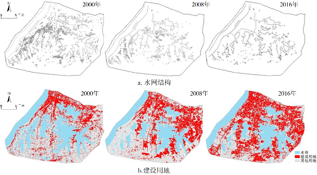
表5 湖泊变化强度指数(C值)Tab.5 Change intensity index of lake in Tangxun Lake basin (C-value) |
| 水系 | 湖泊面积/km2 | 变化量/km2 | C值 | ||||||
|---|---|---|---|---|---|---|---|---|---|
| 2000 | 2008 | 2016 | 2000—2008 | 2008—2016 | 2000—2008 | 2008—2016 | |||
| 汤逊湖水系 | 107.59 | 72.36 | 65.34 | -35.23 | -7.02 | -4.09 | -1.21 | ||
| [1] |
易嘉伟, 王楠, 千家乐, 等. 基于大数据的极端暴雨事件下城市道路交通及人群活动时空响应[J]. 地理学报, 2020, 75(3):497-508.
|
| [2] |
吴志峰, 象伟宁. 从城市生态系统整体性、复杂性和多样性的视角透视城市内涝[J]. 生态学报, 2016, 36(16):4955-4 957.
|
| [3] |
宋晓猛, 张建云, 贺瑞敏, 等. 北京城市洪涝问题与成因分析[J]. 水科学进展, 2019, 30(2):153-165.
|
| [4] |
李海宏, 吴吉东. 2007—2016年上海市暴雨特征及其与内涝灾情关系分析[J]. 自然资源学报, 2018, 33(12):2136-2 148.
|
| [5] |
李彬烨, 赵耀龙, 付迎春. 广州城市暴雨内涝时空演变及建设用地扩张的影响[J]. 地球信息科学学报, 2015, 17(4):445-450.
|
| [6] |
陈晓玲, 陈莉琼, 陆建忠. 从武汉内涝看城市水生态管理及新型人地关系构建[J]. 生态学报, 2016, 36(16):4952-4 954.
|
| [7] |
陈娜, 马伯, 向辉, 等. 基于径流目标分解的南方低山丘陵区海绵城市建设——以湖南凤凰县为例[J]. 经济地理, 2018, 38(8):67-75.
|
| [8] |
|
| [9] |
|
| [10] |
|
| [11] |
|
| [12] |
|
| [13] |
|
| [14] |
|
| [15] |
|
| [16] |
焦胜, 韩静艳, 周敏, 等. 基于雨洪安全格局的城市低影响开发模式研究[J]. 地理研究, 2018, 37(9):1704-1 713.
|
| [17] |
吴健生, 张朴华. 城市景观格局对城市内涝的影响研究——以深圳市为例[J]. 地理学报, 2017, 72(3):444 - 456.
|
| [18] |
夏军, 张印, 梁昌梅, 等. 城市雨洪模型研究综述[J]. 武汉大学学报:工学版, 2018, 51(2):95 - 105.
|
| [19] |
杨帆, 徐建刚, 林蔚. 基于元胞自动机的低影响开发对城市内涝削减效果模拟[J]. 自然资源学报, 2017, 32(7):1158-1 169.
|
| [20] |
黄清雨, 董军刚, 李梦雅, 等. 暴雨内涝危险性情景模拟方法研究——以上海中心城区为例[J]. 地球信息科学学报, 2016, 18(4):506 - 513.
|
| [21] |
田富强, 程涛, 芦由, 等. 社会水文学和城市水文学研究进展[J]. 地理科学进展, 2018, 37(1):46 - 56.
|
| [22] |
周广胜, 何奇瑾. 城市内涝防治需充分预估气候变化的影响[J]. 生态学报, 2016, 36(16):4961-4 964.
|
| [23] |
张会, 李铖, 程炯, 等. 基于“H-E-V”框架的城市洪涝风险评估研究进展[J]. 地理科学进展, 2019, 38(2):175 - 190.
|
| [24] |
曾忠平, 彭浩轩. 城市湿地损失和内涝灾害响应的遥感分析——以武汉市南湖为例[J]. 长江流域资源与环境, 2018, 27(4):929 - 938.
|
| [25] |
陈雄志. 武汉市汤逊湖、南湖地区系统性内涝的成因分析[J]. 中国给水排水, 2017, 33(4):7 - 10,13.
|
| [26] |
武汉市水务局. 武汉湖泊志[M]. 武汉: 湖北省美术出版社, 2014.
|
| [27] |
张意林, 覃军, 陈正洪. 近56a武汉市降水气候变化特征分析[J]. 暴雨灾害, 2008, 27(3):253 - 257.
|
| [28] |
徐涵秋. 利用改进的归一化差异水体指数(MNDWI)提取水体信息的研究[J]. 遥感学报, 2005, 9(5):589 - 595.
|
| [29] |
王洪桥, 袁家冬, 孟祥君. 东北地区A级旅游景区空间分布特征及影响因素[J]. 地理科学, 2017, 37(6):895 - 903.
|
| [30] |
杨利, 石彩霞, 谢炳庚. 长江流域国家湿地公园时空演变特征及其驱动因素[J]. 经济地理, 2019, 39(11):194 - 202.
|
| [31] |
黄浦江, 刘艳芳, 刘畅, 等. 基于RS与GIS的武汉城市湖泊演化研究[J]. 生态环境学报, 2012, 21(9):1588-1 593.
|
| [32] |
翟盘茂, 余荣, 郭艳君, 等. 2015/2016年强厄尔尼诺过程及其对全球和中国气候的主要影响[J]. 气象学报, 2016, 74(3):309 - 321.
|
/
| 〈 |
|
〉 |