
河网型城市土地利用对水安全的影响及其优化管控——以岳阳市为例
|
杨帆(1982—),女,湖南岳阳人,博士,副教授,硕士生导师,研究方向为大湖流域水生态与国土空间规划。E-mail:582228988@qq.com |
收稿日期: 2020-10-17
修回日期: 2021-06-19
网络出版日期: 2025-04-13
基金资助
国家自然科学基金面上项目(72174211)
国家自然科学基金青年项目(51608535)
湖南省自然科学基金项目(2018JJ3667)
湖南省研究生教改课题(2020JGB139)
湖南省社会科学基金项目(19YBA347)
Influence of Land Use on Water Security and Its Optimal Management in River Network City:A Case Study of Yueyang
Received date: 2020-10-17
Revised date: 2021-06-19
Online published: 2025-04-13
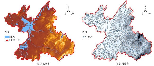
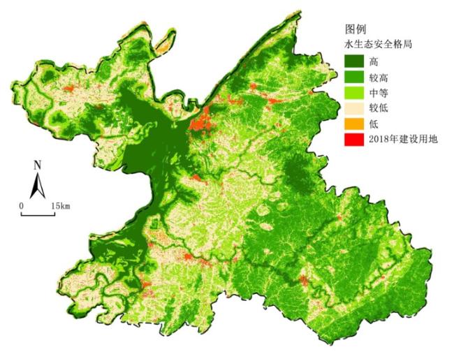
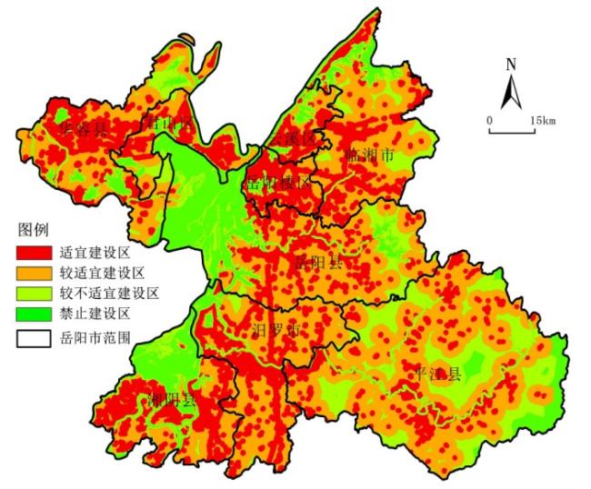
在快速城镇化背景下,流域城镇空间的高强度建设开发不仅推动经济社会发展,同时也对流域的水生态系统造成深远的负面影响。流域内河网型城市建设用地面积急剧扩张、填埋大量支流等不合理的土地利用方式对城市水安全影响尤为显著。文章以典型河网型城市——岳阳市为例,总结其1990—2018年以来土地利用的总体演变特征,探究岳阳市土地利用方式对城市水安全的影响规律,发现建设用地扩展规模和强度与水生态安全等级呈显著反相关关系,进而构建水安全约束条件下岳阳市建设扩展适宜性评价体系,依据评价结果划定城镇建设用地适宜建设区、较适宜建设区、较不适宜建设区、禁止建设区面积分别为2 551.52 km2、3 338.23 km2、4 858.59 km2、3 974.66 km2,最后针对岳阳市建设扩展现状建立管控与问题反馈机制。
杨帆 , 李祝 , 罗文丽 . 河网型城市土地利用对水安全的影响及其优化管控——以岳阳市为例[J]. 经济地理, 2021 , 41(8) : 177 -186 . DOI: 10.15957/j.cnki.jjdl.2021.08.021
Under the background of rapid urbanization,the high-intensity construction and development of urban space in river basin not only promote the economic and social development,but also cause profound negative effects on the water ecosystem in river basin. Unreasonable land use,such as the rapid expansion of construction land area in river network cities and the landfill of tributaries,has a particularly significant impact on water security. Taking the typical river city-Yueyang City as an example,this study summed up the overall evolution characteristics of land use in 1990-2018,and explored the influence of the land use way on the water security,it's found that the scale and strength of construction land expansion had significant negative relationship with the level of water ecological security,it puts forward to build the suitability evaluation system of urban expansion in Yueyang City under the condition of water security constraint,divides construction land into 4 zones which are more suitable zone,suitable zone,less suitable zone and protection zone. According to the evaluation results,the areas of more suitable zone,suitable zone,less suitable zone and protection zone are 2 551.52 km2,3 338.23 km2,4 858.59 km2 and 3 974.66 km2 respectively. Finally,it establishes the control and problem feedback mechanism according to the construction expansion of Yueyang City.
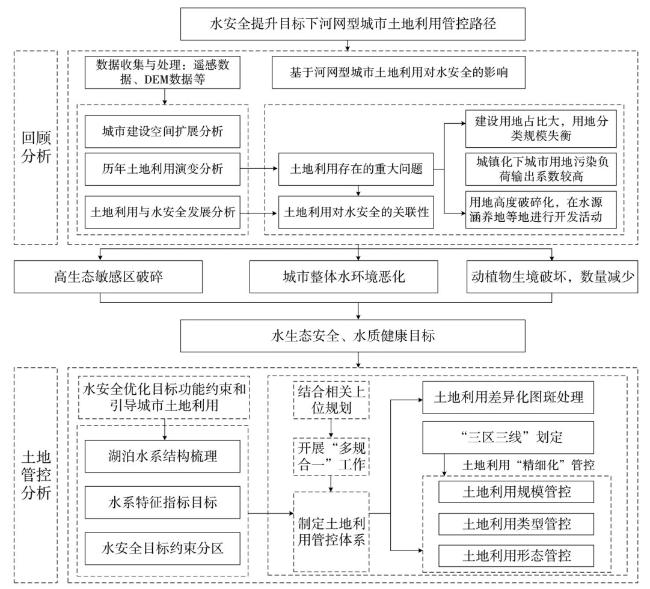
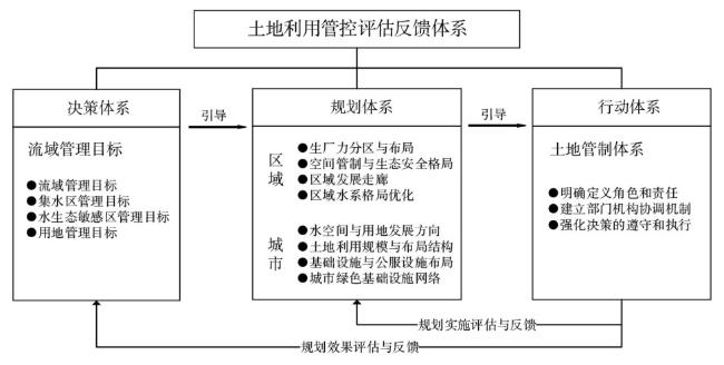
图2 水安全提升目标下河网型城市土地利用管控路径图Fig.2 Route map of urban land use control in river network under the constraint of water security objective |
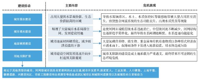
表1 河网型城市建设用地开发强度对水环境的影响表现Tab.1 Impact of development intensity of construction land on water environment in river network city |
| 建设用地开发强度比例(%) | 污染物排放程度 | 水环境恶化速率 | 对湖泊河流的改变 |
|---|---|---|---|
| 强度≥50% | 具有排放总量较大、水文径流反常等特征 | 加速恶化水环境质量的趋势 | 河道占用、河床硬化、筑坝截流等现象 |
| 50%≥强度≥20% | 开发强度及总体排放适中,对污水的管理水平较低,出现污物直排等现象 | 水环境质量恶化呈现明显加速态势 | 对河道与河床系统有一定程度改造 |
| 强度≤20% | 总体排放较小,但是总体污水管理水平及建设径流控制水平较低 | 水环境恶化速率较低 | 对河道与河床系统改变较小 |
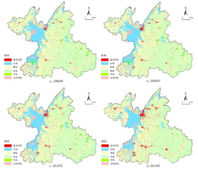
表2 1990—2018年岳阳市土地利用数据(单位:km2)Tab.2 Statistics of land use in Yueyang City from 1990 to 2018 (Unit:km2) |
| 年份 | 耕地 | 建设用地 | 林地 | 草地 | 未利用地 | 水域 |
|---|---|---|---|---|---|---|
| 1990 | 5 355.76 | 264.05 | 6 508.44 | 204.98 | 231.03 | 2 298.50 |
| 2000 | 5 319.39 | 292.77 | 6 508.97 | 197.69 | 230.60 | 2 313.32 |
| 2010 | 5 272.77 | 340.18 | 6 495.60 | 161.28 | 249.01 | 2 329.02 |
| 2018 | 5 159.96 | 590.97 | 6 483.41 | 216.75 | 193.35 | 2 214.80 |
图4 岳阳市1990、2000、2010、2018年土地利用变化图Fig.4 Land development intensity change chart of Yueyang city in 1980,1990,2000,2010 and 2018 |
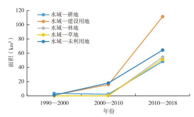
表3 1990—2000年岳阳市土地利用转移矩阵(单位:km2)Tab.3 Land use transfer matrix (area) of Yueyang City in1990-2000 (Unit:km2) |
| 1990 | 2000 | |||||||
|---|---|---|---|---|---|---|---|---|
| 耕地 | 建设用地 | 林地 | 草地 | 未利用地 | 水域 | 总计 | 减少 | |
| 耕地 | 5 312.72 | 19.62 | 8.05 | 0.01 | 0.00 | 15.34 | 5 355.76 | 43.04 |
| 建设用地 | - | 264.05 | - | - | - | - | 264.05 | 0 |
| 林地 | 3.08 | 7.40 | 6 493.72 | 2.54 | - | 1.70 | 6 508.44 | 14.72 |
| 草地 | 0.10 | 0.71 | 6.96 | 195.14 | - | 2.06 | 204.98 | 9.84 |
| 未利用地 | 0.01 | - | 0.19 | - | 229.52 | 1.31 | 231.03 | 1.51 |
| 水域 | 3.48 | 0.99 | 0.05 | - | 1.07 | 2 292.91 | 2 298.50 | 5.59 |
| 总计 | 5 319.39 | 292.77 | 6 508.97 | 197.69 | 230.60 | 2 313.32 | 14 861.86 | |
| 新增 | 6.67 | 28.72 | 15.25 | 2.55 | 7.65 | 20.41 | ||
表4 2000—2010年岳阳市土地利用转移矩阵(单位:km2)Tab.4 Land use transfer matrix of Yueyang City in 2000-2010 (Unit:km2) |
| 2000 | 2010 | |||||||
|---|---|---|---|---|---|---|---|---|
| 耕地 | 建设用地 | 林地 | 草地 | 未利用地 | 水域 | 总计 | 减少 | |
| 耕地 | 5 270.35 | 26.03 | 8.16 | 0.00 | 1.40 | 13.32 | 5 319.27 | 48.92 |
| 建设用地 | 0.01 | 292.37 | 0.00 | - | 0.01 | 0.37 | 292.77 | 0.40 |
| 林地 | 0.13 | 19.64 | 6 486.45 | - | 0.03 | 2.10 | 6 508.35 | 21.90 |
| 草地 | - | 0.26 | 0.63 | 160.85 | 3.28 | 32.60 | 197.62 | 36.77 |
| 未利用地 | 0.00 | - | - | 0.01 | 226.24 | 4.35 | 230.60 | 4.36 |
| 水域 | 2.28 | 15.88 | 0.35 | 0.42 | 18.05 | 2 276.28 | 2 313.26 | 36.98 |
| 总计 | 5 272.77 | 354.18 | 6 495.60 | 161.28 | 249.01 | 2 329.02 | 14 861.86 | |
| 新增 | 2.42 | 61.81 | 9.15 | 0.43 | 22.77 | 52.74 | ||
表5 2010—2018年岳阳市土地利用转移矩阵(单位:km2)Tab.5 Land use transfer matrix(area)of Yueyang City,2010-2018 (Unit:km2) |
| 2010 | 2018 | |||||||
|---|---|---|---|---|---|---|---|---|
| 耕地 | 建设用地 | 林地 | 草地 | 未利用地 | 水域 | 总计 | 减少 | |
| 耕地 | 5 074.06 | 82.32 | 40.14 | 0.89 | 10.18 | 64.98 | 5 272.77 | 198.71 |
| 建设用地 | 6.11 | 324.24 | 5.57 | 0.90 | 0.04 | 3.14 | 340.18 | 15.94 |
| 林地 | 26.18 | 71.76 | 6 380.81 | 8.66 | 1.68 | 5.81 | 6 495.60 | 114.79 |
| 草地 | 0.24 | 1.18 | 2.29 | 155.02 | 0.04 | 2.24 | 161.28 | 6.26 |
| 未利用地 | 4.98 | 0.02 | 0.02 | 0.00 | 116.98 | 139.74 | 263.01 | 146.03 |
| 水域 | 48.40 | 111.45 | 54.57 | 51.28 | 64.43 | 1 998.89 | 2 329.02 | 330.13 |
| 总计 | 5 159.96 | 590.97 | 6 483.41 | 216.75 | 193.35 | 2 214.81 | 1 4861.86 | |
| 新增 | 85.90 | 266.73 | 102.60 | 61.73 | 76.37 | 215.92 | ||
表6 水安全格局评价指标以及权重赋值表Tab.6 Water environment evaluation index and weight assignment |
| 一级指标 | 二级指标 | 分级赋值 | 权重 | 一级指标 | 二级指标 | 分级赋值 | 权重 | 一级指标 | 二级指标 | 分级赋值 | 权重 | ||
|---|---|---|---|---|---|---|---|---|---|---|---|---|---|
| 洪涝灾害 | 其他区域 | 1 | 0.3 | 坡度(°) | ≤5 | 1 | 0.2 | 土地利用 | 建设用地 | 1 | 0.2 | ||
| 100年一遇 | 2 | 5~20 | 2 | 未利用地 | 2 | ||||||||
| 50年一遇 | 3 | 20~75 | 3 | 耕地、草地 | 3 | ||||||||
| 20年一遇 | 4 | 75~200 | 4 | 林地 | 4 | ||||||||
| 10年一遇 | 5 | >200 | 5 | 水域 | 5 | ||||||||
| 高程(m) | ≤40 | 1 | 0.1 | 河流 | 外围50 m | 1 | 0.2 | ||||||
| 40~100 | 2 | 外围50~100 m | 2 | ||||||||||
| 100~150 | 3 | 外围100~200 m | 3 | ||||||||||
| 150~200 | 4 | 外围200~300 m | 4 | ||||||||||
| >500 | 5 | 外围300m | 5 |
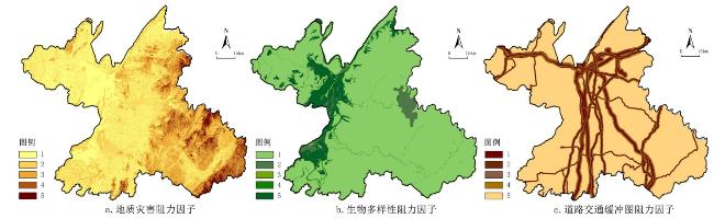
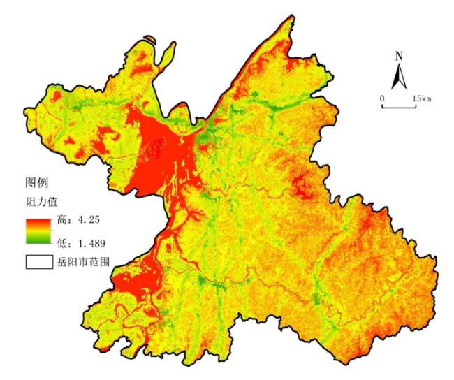
表7 土地建设生态适宜性评价指标体系及权重表Tab.7 Evaluation index system and weight table of ecological suitability of land construction |
| 赋值 | 生态阻力因子 | 社会阻力因子 | ||||||
|---|---|---|---|---|---|---|---|---|
| 水生态安全等级 | 地质灾害易发等级 | 生物多样性敏感等级 | 主要道路距离 | |||||
| 铁路 | 高速 | 一级公路 | 二级公路 | |||||
| 5 | 低安全 | 极易发 | 极重要 | >5 000 | >5 000 | >5 000 | >2 000 | |
| 4 | 较低安全 | 高易发 | 高度重要 | 4 000~5 000 | 4 000~5 000 | 4 000~5 000 | 1 500~2 000 | |
| 3 | 中等安全 | 中等易发 | 中等重要 | 3 000~4 000 | 3 000~4 000 | 3 000~4 000 | 1 000~1 500 | |
| 2 | 较高安全 | 一般易发 | 一般重要 | 2 000~3 000 | 2 000~3 000 | 2 000~3 000 | 500~1 000 | |
| 1 | 高安全 | 不易发 | 不重要 | 0~2 000 | 0~2 000 | 0~2 000 | 0~500 | |
| 权重 | 0.45 | 0.15 | 0.2 | 0.2 | ||||
表8 岳阳市用地分级管控分析Tab.8 Analysis on the hierarchical control of land use along Yueyang City |
| 一级分类 | 二级分类 | 具体区域 | 管控要求 |
|---|---|---|---|
| 一级管控区 | 自然保护区的核心区和缓自然保护区的核心区和缓冲区、饮用水水源保护区的一级保护区、国家级水产种质资源保护区核心区湿地公园的湿地保育区和恢复重建区 | 湖南东洞庭湖国家级自然保护区、湖南云溪白泥湖国家湿地公园、君山公园风景名胜区、湖南华容集成麋鹿省級自然保护区、湖南华容集成长江故道江豚省级自然保护区等 | 湖南东洞庭湖国家级自然保护区、湖南云溪白泥湖国家湿地公园、君山公园风景名胜区、湖南华容集成麋鹿省級自然保护区、湖南华容集成长江故道江豚省级自然保护区等 |
| 二级管控区 | 各生态敏感点内除一级管控区外的其他区域 | 天井山省级森林公园、桃花山省级森林公园、清溪省级森林公园等 | 以生态保护为重点,实行差别化的管控措施,严禁有损主导生态功能的一切开发建设活动 |
注:兼具两种功能同一区域,按最严格的要求落实监管措施。 |
| [1] |
贺缠生, 傅伯杰. 美国水资源政策演变及启示[J]. 资源科学, 1998, 20(1):71-77.
|
| [2] |
|
| [3] |
汪恕诚. 人与自然和谐相处——破解中国水问题的核心理念[J]. 今日国土, 2004, Z2:8-11.
|
| [4] |
焦胜, 曾光明, 何理, 等. 城市滨水区复合开发模式研究[J]. 经济地理, 2003, 23(3):397-400.
|
| [5] |
|
| [6] |
姜畅, 刘鸿雁, 陈竹, 等. 基于 GIS 的红枫湖流域土地利用变化与水质响应[J]. 农业环境科学学报, 2018, 37(6):1232-1239.
|
| [7] |
|
| [8] |
Austrian Standards Institute. Guidelines for the ecological survey and evaluation of flowing surface waters[R]. Vienna: Austrian Standards Norm M6232, 1997:38.
|
| [9] |
陈雯, 禚振坤, 赵海霞, 等. 水环境约束分区与空间开发引导研究——以无锡市为例[J]. 湖泊科学, 2008(1):129-134.
|
| [10] |
胡和兵. 城市化背景下流域土地利用变化及其对河流水质影响研究[D]. 南京: 南京师范大学, 2013.
|
| [11] |
张殷俊, 陈爽, 彭立华. 平原河网地区水质与土地利用格局关系——以江苏吴江为例[J]. 资源科学, 2009, 31(12):2150-2156.
|
| [12] |
杨帆, 唐菲儿. 河网型城市雨洪生态空间规划:方法体系与控制框架——以岳阳市雨洪生态空间规划为例[J]. 城市发展研究, 2019, 26(8):23-30.
|
| [13] |
叶强, 莫正玺, 许乙青. 1979—2014年长沙市城市功能用地扩展与驱动力研究[J]. 地理研究, 2019, 38(5):1063-1079.
|
| [14] |
张国平. 基于生态系统服务功能的龙河流域生态系统健康研究[D]. 重庆: 重庆大学, 2006.
|
| [15] |
焦胜, 魏春雨, 柳肃, 等. 长株潭城市群绿心保护性开发策略研究[J]. 经济地理, 2009, 29(10):1716-1719,1742.
|
| [16] |
崔丹, 陈岩, 马冰然, 等. 土地利用/景观格局对水环境质量的影响[J]. 水科学进展, 2019, 30(3):423-433.
|
| [17] |
邹宇, 许乙青, 邱灿红. 南方多雨地区海绵城市建设研究——以湖南省宁乡县为例[J]. 经济地理, 2015, 35(9):65-71,78.
|
| [18] |
夏汉平. 论长江与珠江流域的水灾、水土流失及植被生态恢复工程[J]. 热带地理, 1999(2):29-34,64.
|
| [19] |
国家防汛抗旱总指挥部, 中华人民共和国水利部中国. 水旱灾害公报:2006[M]. 北京: 中国水利水电出版社, 2007.
|
| [20] |
|
| [21] |
邢忠. “边缘效应”与城市生态规划[J]. 城市规划, 2001(6):44-49.
|
| [22] |
|
| [23] |
李静芝, 闫雪, 李景保. 长江中游荆南三口河网地区生态系统健康评价[J]. 水土保持研究, 2019, 26(4):272-279.
|
| [24] |
张殿发, 王世杰, 李瑞玲. 土地利用/土地覆被变化对长江流域水环境的影响研究[J]. 地域研究与开发, 2003(1):69-72.
|
| [25] |
苏泳娴, 张虹鸥, 陈修治, 等. 佛山市高明区生态安全格局和建设用地扩展预案[J]. 生态学报, 2013, 33(5):1524-1534.
|
| [26] |
谢高地, 张彩霞, 张昌顺, 等. 中国生态系统服务的价值[J]. 资源科学, 2015(9):1740-1746.
|
| [27] |
叶玉瑶, 苏泳娴, 张虹鸥, 等. 生态阻力面模型构建及其在城市扩展模拟中的应用[J]. 地理学报, 2014, 69(4):485-496.
|
/
| 〈 |
|
〉 |