
基于生命共同体的景观生态风险评价与管控策略——以成渝城市群为例
|
梁发超(1983—),男,安徽太和人,博士,教授,硕士生导师,研究方向为土地利用与景观规划、土地资源与城市管理。E-mail:liangfachao1983@163.com |
收稿日期: 2020-10-21
修回日期: 2021-03-10
网络出版日期: 2025-04-13
基金资助
教育部人文社会科学研究规划基金项目(19YJA630043)
国家自然科学基金项目(42077434)
2018年度福建省高等学校杰出青年科研人才培育计划
Risk Assessment of Landscape Ecology and Its Control Strategy Based on Life Community:A Case Study of Chengdu-Chongqing Urban Agglomeration
Received date: 2020-10-21
Revised date: 2021-03-10
Online published: 2025-04-13
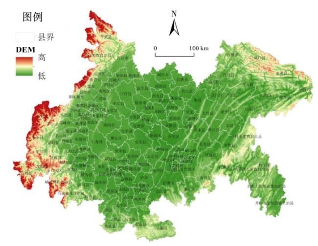
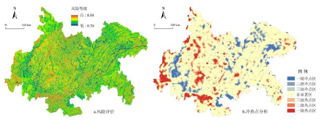
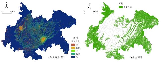
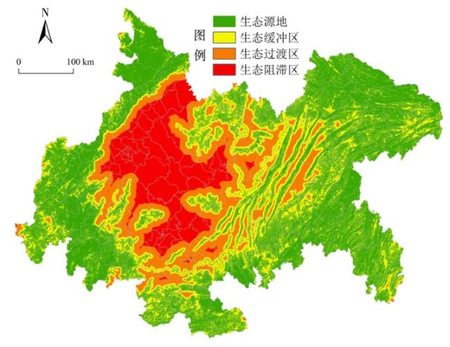
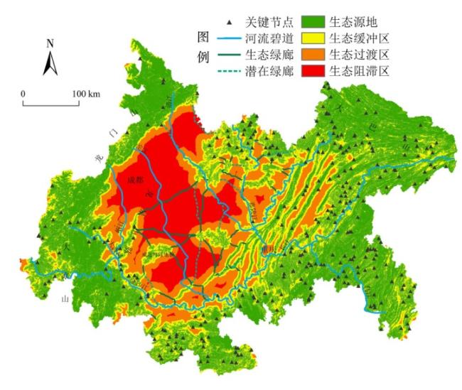
基于“生命共同体”理念开展景观生态风险评价及管控策略研究是推动城市群高质量绿色发展的关键举措。以此理念为指导,从“地形山势—河湖水体—土壤环境—人类活动—景观结构”5个维度构建城市群景观生态风险评价体系,以成渝城市群为典型案例区,诊断其生命共同体健康状态;进一步耦合景观生态安全格局和电路理论,提出成渝城市群景观格局网络化管控策略。结果表明:研究区生境质量指数均值为0.94,66.85%区域景观生态风险处于中低水平,总体生态环境较好,但也存在风险高低区交错现象;识别出生态源地111 461.62 km2,约占总面积46.54%,划分生态阻滞区、生态过渡区、生态缓冲区,占总面积比例分别为25.61%、14.65%、13.20%;构建“76+8”廊道系统,长约5 046.19 km,确定316处生态节点,构筑管控景观生态风险的绿色网络体系,维持成渝城市群景观生态系统健康和可持续发展。
梁发超 , 胡其玉 , 起晓星 . 基于生命共同体的景观生态风险评价与管控策略——以成渝城市群为例[J]. 经济地理, 2021 , 41(8) : 152 -159 . DOI: 10.15957/j.cnki.jjdl.2021.08.018
Research on risk assessment of landscape ecology and its management strategy based on the concept of "life community" is the key measure to promote the high-quality economic-green development of urban agglomeration. Under the guidance of this concept,the risk assessment system of landscape ecology in urban agglomerations was constructed from five dimensions of "terrain landform-water body environment-soil environment-human activities-landscape structure",so that the health status of the life community could be diagnosed in Chengdu-Chongqing Urban Agglomeration. Based on this,the optimization network of landscape pattern in the region was constructed by further coupling the circuit theory and the landscape ecological security pattern. Results showed that the mean value of the habitat quality index was 0.94,and the landscape ecological risk of 66.85% region was in the middle and low level. The overall ecological environment was not bad,but there was also the interlacing phenomenon of high and low risk region. The identified ecological source area was 111 461.62 km2,accounting for 46.54% of the total area. It was divided into ecological blocking zone,ecological transition zone and ecological buffer zone,which accounted for 25.61%,14.65% and 13.20% of the all regions respectively. The "76+8" corridor system, 5 046.19 km long, included 316 key ecological nodes. An ecological network system for landscape ecological risk control was built to maintain the healthy development of the ecosystem in Chengdu-Chongqing Urban Agglomeration. The ecological network system for landscape ecological risk control was built to maintain the healthy and sustainable development of the ecosystem in Chengdu-Chongqing Urban Agglomeration. The research results provide theoretical support and methodological guidance for landscape ecological planning in urban agglomeration.
表1 景观生态风险评价指标体系Tab.1 The index system of landscape |
| 评价 维度 | 评价 因子 | 因子 权重 | 分级标准 | 分级 赋值 |
|---|---|---|---|---|
| 地 形 山 势 | 坡度(°) | 0.09 | 0~8 | 1 |
| 8~15 | 3 | |||
| 15~25 | 5 | |||
| 25~35 | 7 | |||
| >35 | 9 | |||
| 海拔(m) | 0.03 | <500 | 1 | |
| 500~1 000 | 3 | |||
| 1 000~1 500 | 5 | |||
| 1 500~2 000 | 7 | |||
| >2 000 | 9 | |||
| 河 湖 水 体 | 距河流水系距离(m) 距湖泊水库距离(m) | 0.16 0.16 | <100 | 1 |
| 100~200 | 3 | |||
| 200~800 | 5 | |||
| 800~2 000 | 7 | |||
| >2 000 | 9 | |||
| 土 壤 环 境 | 土壤类型 | 0.03 | 黑黏土(亚高山草甸土) | 1 |
| 紫色土 | 3 | |||
| 红壤、赤红壤、南方水稻土 | 5 | |||
| 黄壤、棕壤、黄棕壤 | 7 | |||
| 石灰土 | 9 | |||
| 土壤侵蚀 | 0.09 | 微度、轻度 | 1 | |
| 中度 | 3 | |||
| 强烈 | 5 | |||
| 极强烈 | 7 | |||
| 剧烈 | 9 | |||
| 人 类 活 动 | 距城镇建设区距离(m) | 0.03 | >3 000 | 1 |
| 2 000~3 000 | 3 | |||
| 1 000~2 000 | 5 | |||
| 500~1 000 | 7 | |||
| <500 | 9 | |||
| 距农村居民区距离(m) | 0.03 | >2 000 | 1 | |
| 1 000~2 000 | 3 | |||
| 500~1 000 | 5 | |||
| 250~500 | 7 | |||
| <250 | 9 | |||
| 土地利用强度 | 0.16 | 森林 | 1 | |
| 湿地、水域 | 3 | |||
| 草地、灌木林地等 | 5 | |||
| 农田 | 7 | |||
| 裸地等未利用地、建设用地 | 9 | |||
| 景 观 结 构 | 景观干扰指数 | 0.22 | <8.35 | 1 |
| 8.35~13.85 | 3 | |||
| 13.85~19.14 | 5 | |||
| 19.14~24.84 | 7 | |||
| >24.84 | 9 |
ecological risk assessment |
| [1] |
杨桂山, 徐昔保. 长江经济带“共抓大保护、不搞大开发”的基础与策略[J]. 中国科学院院刊, 2020, 35(8):940-950.
|
| [2] |
彭建, 李慧蕾, 刘焱序, 等. 雄安新区生态安全格局识别与优化策略[J]. 地理学报, 2018, 73(4):701-710.
|
| [3] |
|
| [4] |
|
| [5] |
汪翡翠, 汪东川, 张利辉, 等. 京津冀城市群土地利用生态风险的时空变化分析[J]. 生态学报, 2018, 38(12):4307-4316.
|
| [6] |
|
| [7] |
|
| [8] |
|
| [9] |
方莹, 王静, 黄隆杨, 等. 基于生态安全格局的国土空间生态保护修复关键区域诊断与识别——以烟台市为例[J]. 自然资源学报, 2020, 35(1):190-203.
|
| [10] |
|
| [11] |
|
| [12] |
杨永春, 张旭东, 穆焱杰, 等. 黄河上游生态保护与高质量发展的基本逻辑及关键对策[J]. 经济地理, 2020, 40(6):9-20.
|
| [13] |
吕永龙, 王尘辰, 曹祥会. 城市化的生态风险及其管理[J]. 生态学报, 2018, 38(2):359-370.
|
| [14] |
黄寰, 肖义, 王洪锦. 成渝城市群社会—经济—自然复合生态系统生态位评价[J]. 软科学, 2018, 32(7):113-117.
|
| [15] |
|
| [16] |
翟俊, 侯鹏, 赵志平, 等. 青海湖流域景观格局空间粒度效应分析[J]. 国土资源遥感, 2018, 30(3):159-166.
|
| [17] |
李霖, 苏世亮, 翁敏, 等. 生命共同体监评理论框架研究[J]. 地理信息世界, 2019, 26(4):1-6.
|
| [18] |
宇振荣, 杨新民, 陈雅杰. 河南省南太行地区山水林田湖草生态保护与修复[J]. 生态学报, 2019, 39(23):8886-8895.
|
| [19] |
刘珍环, 张国杰, 付凤杰. 基于景观格局—服务的景观生态风险评价——以广州市为例[J]. 生态学报, 2020, 40(10):3295-3302.
|
| [20] |
高俊刚, 吴雪, 张镱锂, 等. 基于等级层次分析法的金沙江下游地区生态功能分区[J]. 生态学报, 2016, 36(1):134-147.
|
| [21] |
徐秋阳, 王巍巍, 莫罹. 京津冀地区景观稳定性评价[J]. 生态学报, 2018, 38(12):4226-4233.
|
| [22] |
宁启蒙, 欧阳海燕, 汤放华, 等. 土地利用变化影响下洞庭湖地区景观格局的时空演变[J]. 经济地理, 2020, 40(9):196-203.
|
| [23] |
郑茜, 曾菊新, 罗静, 等. 武汉市生态网络空间结构及其空间管治研究[J]. 经济地理, 2018, 38(9):191-199.
|
| [24] |
|
| [25] |
|
| [26] |
|
| [27] |
|
| [28] |
彭建, 徐飞雄. 不同格网尺度下的黄山市生境质量差异分析[J]. 地球信息科学学报, 2019, 21(6):887-897.
|
| [29] |
李青圃, 张正栋, 万露文, 等. 基于景观生态风险评价的宁江流域景观格局优化[J]. 地理学报, 2019, 74(7):1420-1437.
|
| [30] |
梁发超, 刘浩然, 刘诗苑, 等. 闽南沿海景观生态安全网络空间重构策略——以厦门市集美区为例[J]. 经济地理, 2018, 38(9):231-239.
|
| [31] |
宋利利, 秦明周. 整合电路理论的生态廊道及其重要性识别[J]. 应用生态学报, 2016, 27(10):3344-3352.
|
| [32] |
张玥, 许端阳, 李霞, 等. 中—老交通走廊核心区生态廊道构建与关键节点识别[J]. 生态学报, 2020, 40(6):1933-1943.
|
| [33] |
王洁, 摆万奇, 田国行. 土地利用生态风险评价研究进展[J]. 自然资源学报, 2020, 35(3):576-585.
|
/
| 〈 |
|
〉 |