
基于夜间灯光遥感数据的环洞庭湖生态经济区城市群时空扩展
|
李茜铭(1990—),女,湖南岳阳人,博士研究生,研究方向为城市空间结构与发展控制、基于遥感数据的城市分析。E-mail:188379083@qq.com |
收稿日期: 2020-05-23
修回日期: 2020-10-31
网络出版日期: 2025-04-01
基金资助
国家自然科学基金面上项目(51478470)
湖南省研究生科研创新项目(CX2018B075)
中南大学研究生自主探索创新项目重点项目(502221802)
Spatio-Temporal Expansion of the Dongting Lake Eco-economic Zone Urban Agglomeration Based on Nighttime Light Remote Sensing Data
Received date: 2020-05-23
Revised date: 2020-10-31
Online published: 2025-04-01
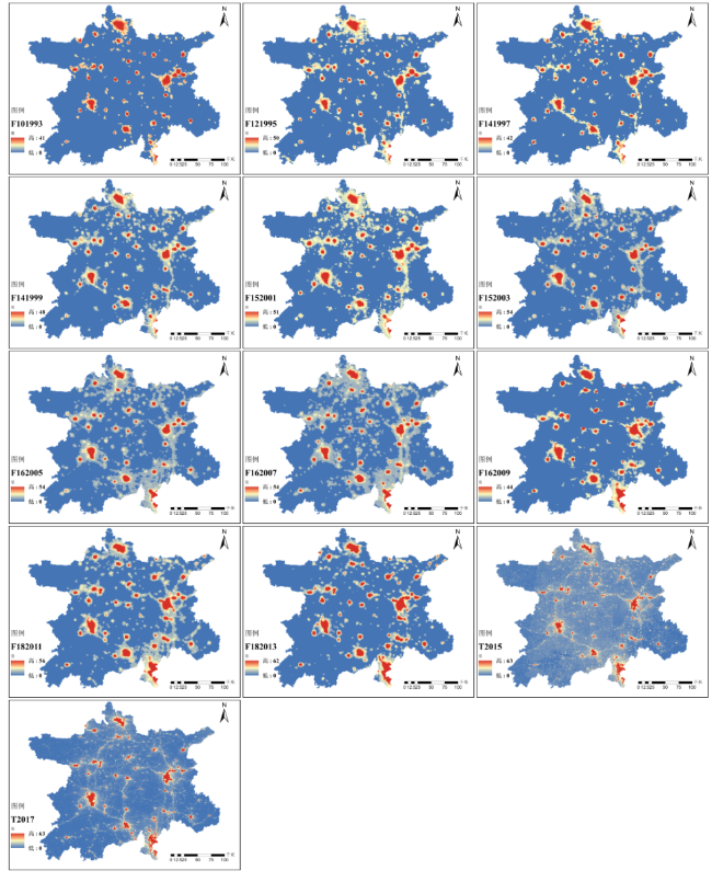
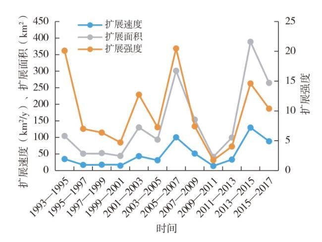
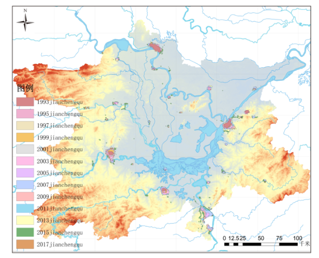
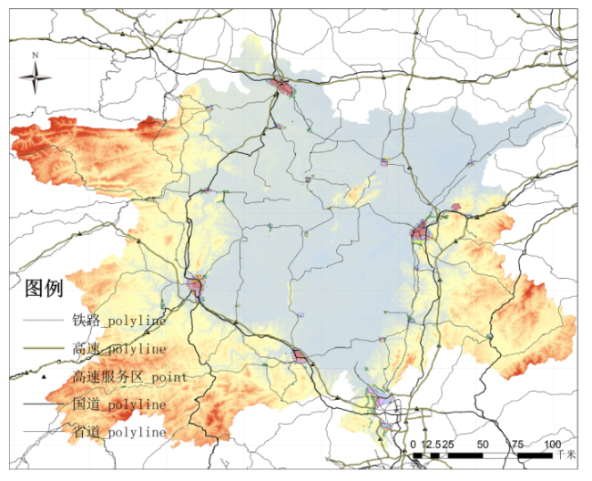
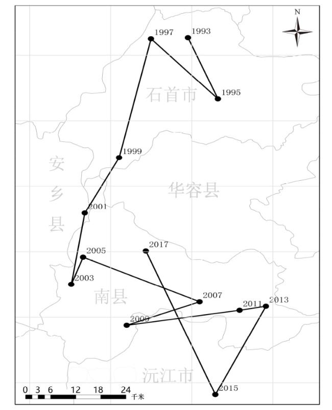
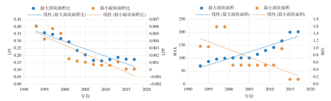
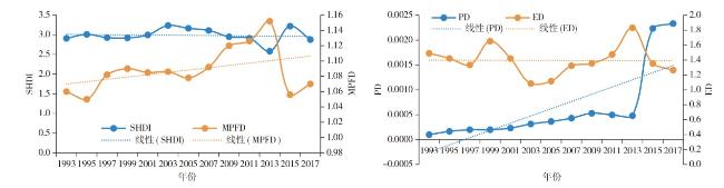
文章基于1993—2017年环洞庭湖生态经济区城市群DMSP/OLS和NPP-VIIRS夜间灯光遥感数据与ArcGIS,采用参考数据辅助对比法提取城市群建成区范围,利用Landsat 8遥感影像和Kappa系数进行精度检验,运用时空扩展规模、重心偏移及景观格局形态分析方法对城市群演变进行分析。主要结论如下:①动态阈值法提取夜光数据城市群建成区与实际符合,演变规律与规划、经济和政策贴合,经过中速调整过渡—高速边缘扩展—低速内部填充—快速飞地式扩展过程,呈现复杂周期性变化。②城市群重心由荆州市石首市南移至益阳市南县内,常德市与岳阳市主导城市群快速发展。③景观格局破碎度较高,空间连通性较弱,城镇相对独立,城市群呈“五核”空间扩展模式。
李茜铭 , 郑伯红 , 熊羽军 . 基于夜间灯光遥感数据的环洞庭湖生态经济区城市群时空扩展[J]. 经济地理, 2021 , 41(2) : 92 -102 . DOI: 10.15957/j.cnki.jjdl.2021.02.010
This paper combines the nighttime light remote sensing data of DMSP / OLS and NPP-VIIRS in the Dongting Lake Eco-economic Zone Urban Agglomeration from 1993 to 2017 with ArcGIS. The reference data-assisted comparison method is used to extract the range of built-up area of the urban agglomeration. It uses the remote sensing images of Landsat 8 and Kappa coefficient to test the research accuracy,and analyzes the evolution of urban agglomeration by the means of the spatial-temporal expansion scale,shift of gravity center and landscape pattern analysis. The main conclusions are as follows: 1) Dynamic threshold method is used to extract the luminous data of urban agglomeration built-up area,which is in line with the actual situation,the law of evolution is consistent with city planning,economy and policy. It shows complex periodic changes in the expansion of the Dongting Lake Eco-economic Zone Urban Agglomeration,which experiences four stages in sequence: medium-speed adjustment transition,high-speed edge expansion,low-speed internal filling,higher-speed enclave expansion. 2) The gravity center of the urban agglomeration moves from Shishou City in Jingzhou City to Nan County in Yiyang City. Changde City and Yueyang City play dominant role in the rapid development of urban agglomeration. 3) The fragmentation of the landscape pattern is high,the spatial connectivity is weak,the cities and towns are relatively independent,and the urban agglomeration presents a "five-core" spatial expansion model.
表1 DMSP/ OLS与VIIRS/DNB夜间灯光遥感数据对比Tab.1 Comparison of night light remote sensing data of DMSP/ OLS and VIIRS/DNB |
| DMSP/OLS夜间 灯光遥感数据 | VIIRS/DNB夜间 灯光遥感数据 | |
|---|---|---|
| 微光探测最小值 | 10-5~10-9 W·cm-2·sr-1 | 10-5~10-7 W·m-2·sr-1 |
| 运行周期长度 | 850 km | 824 km |
| 采样频率间隔 | 0.56 km | 0.755±0.022 km |
| 获取图像的幅宽 | 3 000 km | 3 040 km |
| 空间分辨率 | 5~7 km | 400~750 m |
| 中心波长 | 600 nm | 700 nm |
| 波长范围 | 510~910 nm | 500~900 nm |
表2 2017年Kappa系数精度检验混淆矩阵Tab.2 Confusion matrix of accuracy test based on Kappa coefficient in 2017 |
| 城镇用地(m2) | 非城镇用地(m2) | 总和(m2) | 用户精度(%) | |
|---|---|---|---|---|
| 城镇用地(m2) | 45 755 629.75 | 9 994 065.66 | 55 749 695.41 | 82.07 |
| 非城镇用地(m2) | 7 307 123.34 | 86 965 728.19 | 94 272 851.53 | 92.25 |
| 总和(m2) | 53 062 753.09 | 96 959 793.85 | 150 022 546.94 | |
| 生产者精度(%) | 86.23 | 89.69 | ||
| Kappa系数=0.7533 | ||||
表3 重心偏移数据表Tab.3 Offset data of gravity center |
| 时间 | 偏移距离(m) | 偏移角度(°) | 偏移速度(m/s) |
|---|---|---|---|
| 1993—1995 | 18 261.02 | -70.21 | 9 130.51 |
| 1995—1997 | 21 556.88 | 128.87 | 10 778.44 |
| 1997—1999 | 34 093.37 | -100.02 | 17 046.69 |
| 1999—2001 | 17 063.24 | -113.01 | 8 531.62 |
| 2001—2003 | 20 286.00 | -97.03 | 10 143.00 |
| 2003—2005 | 8 028.15 | 73.48 | 4 014.08 |
| 2005—2007 | 26 471.48 | -27.74 | 13 235.74 |
| 2007—2009 | 16 007.88 | -154.90 | 8 003.94 |
| 2009—2011 | 22 978.48 | 11.32 | 11 489.24 |
| 2011—2013 | 5 377.84 | 12.79 | 2 688.92 |
| 2013—2015 | 26 905.37 | -111.33 | 13 452.68 |
| 2015—2017 | 42 859.38 | 109.66 | 21 429.69 |
| [1] |
|
| [2] |
|
| [3] |
|
| [4] |
王翠平, 王豪伟, 李春明, 等. 基于DMSP/OLS影像的我国主要城市群空间扩张特征分析[J]. 生态学报, 2012, 32(3):942-954
|
| [5] |
|
| [6] |
|
| [7] |
公维民, 张志斌, 王凯佳, 等. 基于夜间灯光数据的兰白西城市群空间扩展分析[J]. 资源开发与市场, 2018, 34(8):1048-1053.
|
| [8] |
|
| [9] |
中华人民共和国国家发展和改革委员会. 国家发展改革委关于印发洞庭湖生态经济区规划的通知[EB/OL]. https://www.ndrc.gov.cn/xxgk/zcfb/tz/201405/t20140512_964118.html, 2014-05-02
|
| [10] |
李俊峰, 潘竟虎. 基于夜间灯光的1992—2012年甘肃省城市空间扩展研究[J]. 冰川冻土, 2016, 38(3):829-835.
|
| [11] |
舒松, 余柏蒗, 吴健平, 等. 基于夜间灯光数据的城市建成区提取方法评价与应用[J]. 遥感技术与应用, 2011, 26(2):169-176.
|
| [12] |
|
| [13] |
|
| [14] |
李颖, 冯玉, 彭飞, 等. 基于地理探测器的天津市生态用地格局演变[J]. 经济地理, 2017, 37(12):180-189.
|
| [15] |
|
| [16] |
|
| [17] |
查凯丽, 彭明军, 刘艳芳, 等. 武汉城市圈路网通达性与经济联系时空演变及关联分析[J]. 经济地理, 2017, 37(12):74-81,210.
|
| [18] |
方创琳, 高倩, 张小雷, 等. 城市群扩展的时空演化特征及对生态环境的影响——以天山北坡城市群为例[J]. 中国科学:地球科学, 2019(9):1413-1424.
|
/
| 〈 |
|
〉 |


