
湖南省洞庭湖地区耕地多功能演变及影响因素
|
钟欣秀(1990—),女,高级工程师,研究方向为国土空间规划。E-mail:85418347@qq.com |
收稿日期: 2024-02-03
修回日期: 2025-03-20
网络出版日期: 2025-08-28
基金资助
国家自然科学基金面上项目(42471241)
The Evolution and Influence Factors of Cultivated Land Multifunctionality in the Dongting Lake Region, Hunan Province
Received date: 2024-02-03
Revised date: 2025-03-20
Online published: 2025-08-28
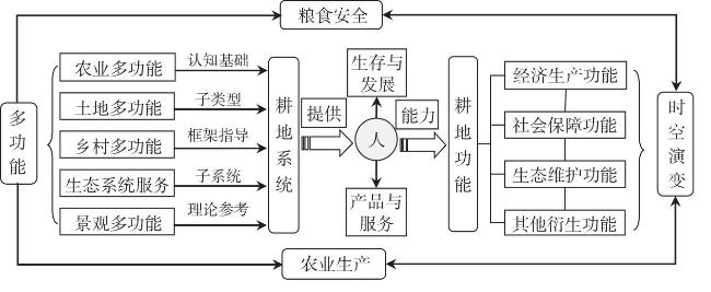
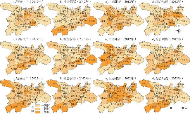
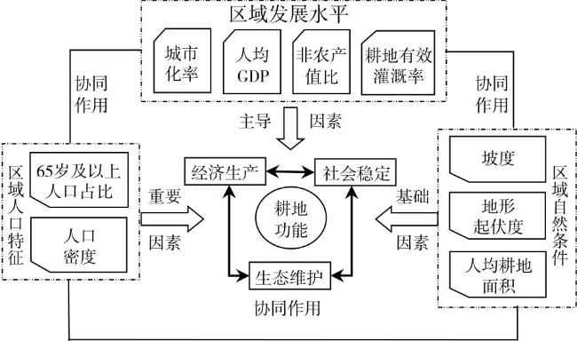
揭示耕地多功能时空演变规律及其影响因素是制定可持续耕地管理政策、保障粮食安全与生态安全的基础。文章采用熵值法、地理探测器等方法,结合GIS技术,从经济生产、社会保障以及生态维护3个维度对2012、2017和2022年湖南省洞庭湖地区耕地多功能的时空演变及其影响因素进行了研究。 结果表明:①2012—2022年,洞庭湖地区耕地经济生产功能整体为增强态势,呈“西高东低”的格局;耕地社会保障功能在洞庭湖地区西部增强明显,整体呈“中部、西部高”的特征;耕地生态维护功能的高值区逐渐呈集聚态势,表现为“中间高、四周低”的特征;耕地综合功能则表现为西部、西南部持续增强的特征。②耕地多功能演变的影响因素从大到小依次为城市化率、人口密度、人均耕地面积、地形起伏度、65岁及以上人口比重、非农产值比、耕地有效灌溉率、人均GDP、坡度。区域经济发展水平是耕地功能空间分异的主导因素,区域人口特征是重要因素,区域自然条件是基础因素,各因子间存在较为明显的增强型交互作用,体现出洞庭湖地区耕地多功能时空演变影响因素与机制的复杂性。
钟欣秀 . 湖南省洞庭湖地区耕地多功能演变及影响因素[J]. 经济地理, 2025 , 45(7) : 209 -217 . DOI: 10.15957/j.cnki.jjdl.2025.07.021
Investigating the spatiotemporal evolution patterns of cultivated land multifunctionality and their influencing factors is essential for formulating sustainable land management policies, ensuring food security, and maintaining ecological security. The study employed the entropy method, geographical detector, and GIS technology to analyze the spatiotemporal evolution of cultivated land multifunctionality and its influencing factors in the Dongting Lake area of Hunan Province during 2012, 2017, and 2022. The analysis was conducted from three dimensions: economic production, social security, and ecological maintenance.The results show that: 1)From 2012 to 2022, the economic production function of cultivated land in the Dongting Lake area exhibited an overall strengthening trend, displaying a spatial pattern of "higher in the west and lower in the east";The social security function of cultivated land showed significant enhancement in the western Dongting Lake area, exhibiting an overall pattern characterized by "higher values in central and western regions";The ecological maintenance function of cultivated land exhibited an increasing spatial agglomeration trend, characterized by a "high center, low periphery" pattern. The comprehensive function of cultivated land demonstrated a sustained enhancement trend in the western and southwestern regions. 2)The influence mechanism of spatial differentiation of cultivated land multifunctionality from large to small is urbanization rate > population density > per capita cultivated land area > topographic undulation > Proportion of population aged 65 and above > non-agricultural output value ratio > effective arable land irrigation rate > per capita GDP > slope. The level of regional economic development is the dominant factor in the spatial differentiation of cultivated land multifunctionality. Regional population characteristics are essential, and regional natural conditions are fundamental factors. There are mutually reinforcing actions among the factors, which reflect the complex characteristics of the factors and mechanisms affecting the spatial-temporal evolution of cultivated land functions in the Dongting Lake area.
表1 洞庭湖地区耕地多功能评价指标体系及指标权重Tab.1 Evaluation index system for cultivated land multifunctionality |
| 准则层 | 指标层(单位) | 计算方式 | 指标正负 | 指标权重 | 指标解释 |
|---|---|---|---|---|---|
| 经济生产功能 | 粮食生产能力(t/hm2) | 粮食产量/耕地面积 | + | 0.05 | 粮食生产能力 |
| 蔬菜生产能力(t/hm2) | 蔬菜产量/耕地面积 | + | 0.11 | 经济作物生产 | |
| 油料生产能力(t/hm2) | 油料产量/耕地面积 | + | 0.07 | ||
| 国民经济贡献度(%) | 农业总产值/GDP | + | 0.05 | 经济贡献程度 | |
| 复种指数(%) | 农作物播种面积/耕地面积 | + | 0.11 | ||
| 社会保障功能 | 单位耕地面积产值(万元/hm2) | 农业总产值/耕地面积 | + | 0.08 | 就业—收入保障 |
| 农户最低生活保障水平(元/年) | [农村总人口·各县(市、区)最低生活保障标准]·(农村人均可支配收入/城镇人均可支配收入) | + | 0.08 | ||
| 收入公平指数(%) | 农村人均收入/城镇人均收入 | + | 0.04 | ||
| 单位耕地机械动力(kW/hm2) | 农业机械总动力/耕地面积 | - | 0.17 | 粮食—农机保障 | |
| 粮食自给率(%) | 粮食产量/(地区总人口·400 kg) | + | 0.04 | ||
| 生态维护功能 | 农用化学品使用强度(t/hm2) | 化肥、农药使用量/耕地面积 | - | 0.03 | 污染程度 |
| 地膜使用强度(t/hm2) | 地膜使用量/耕地面积 | - | 0.02 | ||
| 农田生态系统多样性指数(%) | 主要作物播种面积(粮食、蔬菜、油料、棉花、烟叶)/农作物播种面积 | + | 0.03 | 生态维护 | |
| 耕地类型生态优势度(%) | 水田面积/耕地面积 | + | 0.04 | ||
| 土地垦殖率(%) | 耕地面积/土地总面积 | + | 0.06 |
表2 耕地功能演变的影响因素分析指标体系及说明Tab.2 Analytical indicator system of influencing factors for cultivated land multifunctionality |
| 探测因素 | 指标(补充单位) | 探测因子 | 计算方法/数据来源 | 属性 |
|---|---|---|---|---|
| 区域自然条件 | 坡度 | x1 | GIS提取 | - |
| 地形起伏度 | x2 | GIS提取 | - | |
| 人均耕地面积 | x3 | 耕地面积/地区总人口 | + | |
| 区域发展水平 | 城镇化率 | x4 | 地区统计年鉴 | + |
| 人均GDP | x5 | 地区GDP/地区总人口 | + | |
| 非农产值比 | x6 | 地区统计年鉴 | - | |
| 耕地有效灌溉率 | x7 | 地区灌溉面积/地区耕地面积 | + | |
| 区域人口特征 | 65岁及以上人口比重 | x8 | 地区统计年鉴 | - |
| 人口密度 | x9 | 地区土地总面积/地区总人口 | + |
表3 耕地多功能演变的影响因子探测结果Tab.3 Factor detection results for spatial differentiation of cultivated land multifunctionality |
| 探测 指标 | 坡度(x1) | 地形 起伏度 (x2) | 人均耕地面积(x3) | 城市 化率 (x4) | 人均GDP (x5) | 非农 产值比(x6) | 耕地有效灌溉率(x7) | 65岁及以上人口比重(x8) | 人口 密度(x9) |
|---|---|---|---|---|---|---|---|---|---|
| q值 | 0.0631 | 0.4824 | 0.5691 | 0.7081 | 0.1763 | 0.3897 | 0.1807 | 0.4491 | 0.5877 |
表4 耕地多功能演变影响因子交互探测结果Tab.4 Interaction detection results for spatial differentiation of cultivated land multifunctionality |
| 因子 | x1 | x2 | x3 | x4 | x5 | x6 | x7 | x8 | x9 |
|---|---|---|---|---|---|---|---|---|---|
| x1 | 0.0631 | ||||||||
| x2 | 0.7642* | 0.4824 | |||||||
| x3 | 0.7445* | 0.7852* | 0.5877 | ||||||
| x4 | 0.7603* | 0.7699* | 0.8991** | 0.7081 | |||||
| x5 | 0.5795* | 0.9109* | 0.6777* | 0.6371* | 0.1763 | ||||
| x6 | 0.6882* | 0.7851* | 0.7616** | 0.7668* | 0.6044** | 0.3897 | |||
| x7 | 0.6541* | 0.6620* | 0.7065* | 0.9502* | 0.4262** | 0.7249* | 0.1807 | ||
| x8 | 0.7563* | 0.7458* | 0.9214** | 0.7668* | 0.6279* | 0.6594* | 0.9057* | 0.4491 | |
| x9 | 0.8155* | 0.0738* | 0.7078** | 0.9266* | 0.9210** | 0.9070* | 0.7105* | 0.9070* | 0.5691 |
注:*为非线性增强,**为双因子增强。 |
| [1] |
姜广辉, 张凤荣, 孔祥斌, 等. 耕地多功能的层次性及其多功能保护[J]. 中国土地科学, 2011, 25(8):42-47.
|
| [2] |
|
| [3] |
|
| [4] |
|
| [5] |
|
| [6] |
|
| [7] |
何山. 基于多源信息的耕地多功能评价与用途分区研究[D]. 杭州: 浙江大学, 2019.
|
| [8] |
宋小青, 欧阳竹. 耕地多功能内涵及其对耕地保护的启示[J]. 地理科学进展, 2012, 31(7):859-868.
|
| [9] |
谷国政, 宋戈. 辽宁省耕地多功能演变及其价值响应研究[J]. 中国土地科学, 2022, 36(12):103-116.
|
| [10] |
钱凤魁, 迟艳茹, 徐欢, 等. 2006—2020年沈阳市耕地多功能权衡协同关系演变分析[J]. 中国土地科学, 2022, 36(10):31-41.
|
| [11] |
宋小青, 吴志峰, 欧阳竹. 1949年以来中国耕地功能变化[J]. 地理学报, 2014, 69(4):435-447.
|
| [12] |
杨雪, 谈明洪. 近年来北京市耕地多功能演变及其关联性[J]. 自然资源学报, 2014, 29(5):733-743.
|
| [13] |
高星, 宋昭颖, 李晨曦, 等. 城乡梯度下的耕地多功能价值空间分异特征[J]. 农业工程学报, 2021, 37(16):251-259.
|
| [14] |
|
| [15] |
张英男, 龙花楼, 戈大专, 等. 黄淮海平原耕地功能演变的时空特征及其驱动机制[J]. 地理学报, 2018, 73(3):518-534.
|
| [16] |
朱庆莹, 胡伟艳, 赵志尚. 耕地多功能权衡与协同时空格局的动态分析——以湖北省为例[J]. 经济地理, 2018, 38(7):143-153.
|
| [17] |
吴大放, 吴钊骏, 李升发, 等. 粤北山区耕地非粮化演变特征及其影响因素[J]. 经济地理, 2023, 43(8):144-153.
|
| [18] |
郭晓东, 李欢, 谢心雨, 等. 陇中黄土丘陵区“耕—园”转换特征及其驱动机制——以甘肃省秦安县为例[J]. 经济地理, 2024, 44(10):176-184.
|
| [19] |
付兆刚, 许翔宇, 陈臻. 社会——地理关系下粤西县域耕地流转的时空分异及其驱动机制[J]. 经济地理, 2024, 44(7):175-185.
|
| [20] |
|
| [21] |
宋小青, 欧阳竹. 中国耕地多功能管理的实践路径探讨[J]. 自然资源学报, 2012, 27(4):540-551.
|
| [22] |
安悦, 谭雪兰, 李印齐, 等. 洞庭湖地区耕地功能时空演变特征及影响因素研究[J]. 地理科学, 2022, 42(7):1272-1282.
|
| [23] |
罗莎莎, 赖庆标, 王旭东, 等. 基于多功能评价与权衡—协同关系的福建省耕地区划管控[J]. 农业工程学报, 2023, 39(13):271-280.
|
| [24] |
李俊颖. 黑龙江省耕地土壤功能评价及分区研究[D]. 北京: 中国地质大学(北京), 2020.
|
| [25] |
高佳, 赵荣荣, 王盼盼. 耕地多功能对粮食生产能力变化的敏感度研究[J]. 自然资源学报, 2024, 39(6):1434-1449.
|
| [26] |
王劲峰, 徐成东. 地理探测器:原理与展望[J]. 地理学报, 2017, 72(1):116-134.
|
| [27] |
吴大放, 刘艳艳, 张晓露, 等. 1990—2014年广州市耕地功能评价分析[J]. 中国农业资源与区划, 2019, 40(2):64-72.
|
| [28] |
吕立刚, 撖旭, 龙花楼, 等. 耕地多功能供需匹配研究进展与展望[J]. 资源科学, 2023, 45(7):1351-1365.
|
| [29] |
薛继兵, 闵怡斐, 官炎俊, 等. 粮食主销区的耕地多功能演进特征及其保护长效机制——以浙江省海盐县为例[J]. 中国土地科学, 2025, 39(3):58-69.
|
/
| 〈 |
|
〉 |
