
人口流动视角下长三角城市空间网络测度及其腹地划分
|
朱鹏程(1995—),男,江苏镇江人,硕士研究生。主要研究方向为区域发展与城乡规划。E-mail:819366799@qq.com 。 |
收稿日期: 2018-09-11
修回日期: 2019-04-26
网络出版日期: 2025-04-17
基金资助
国家自然科学基金项目(41571124)
Measurement of Urban Spatial Network and Its Hinterworld Division in the Yangtze River Delta from the Perspective of Population Flow
Received date: 2018-09-11
Revised date: 2019-04-26
Online published: 2025-04-17
朱鹏程 , 曹卫东 , 张宇 , 袁婷 , 章屹祯 . 人口流动视角下长三角城市空间网络测度及其腹地划分[J]. 经济地理, 2019 , 39(11) : 41 -48 . DOI: 10.15957/j.cnki.jjdl.2019.11.006
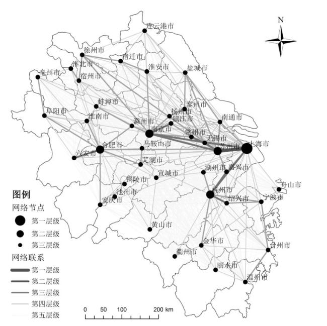
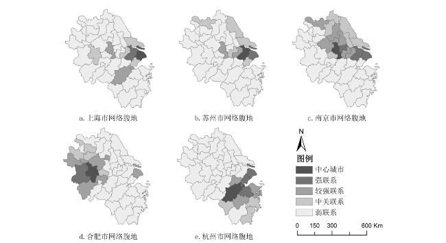
Based on Tencent's population migration data, this paper analyzes the structure of population mobility network of the Yangtze River Delta region by introducing network aggregation degree, node centrality index and two network association measurement methods, then can divide the hinterworld scope of the central city and reveal the spatial structure characteristics. The research shows that: In terms of network research, the population movement in the Yangtze River Delta has significant hierarchical characteristics, and forms a multi-core structure of "one main and four pairs". The spatial distribution of urban pedestrian flow is generally "Z" shape. Network connections show geographical concentration and strong spatial differences, and urban inter-provincial links are weak; In terms of hinterworld research, the spatial structure of the hinterworld of each central city corresponds to the characteristics of the population mobility network, with overlapping and adjacent features, and regional differences. In order to provide a scientific reference for the rational formulation of urban development strategies and the promotion of regional coordinated development.
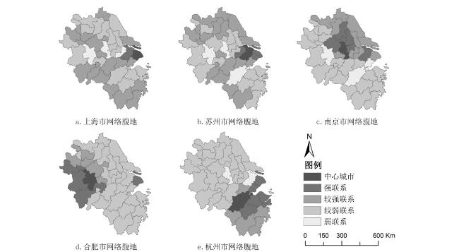
表1 长三角中心城市网络腹地分类表Tab.1 Classification for hinterworld of central city in the Yangtze River Delta |
| 城市层级 | 中心城市 | 城市网络腹地 | ||
|---|---|---|---|---|
| A类腹地 | B类腹地 | C类腹地 | ||
| 第一层级 | 上海 | 嘉兴、南通、苏州 | 杭州、合肥、南京、无锡 | 安庆、蚌埠、亳州、池州、滁州、湖州、淮北、淮南、黄山、丽水、连云港、马鞍山、衢州、台州、铜陵、温州、宣城、舟山 |
| 第二层级 | 苏州 | 嘉兴、南通、上海、无锡、徐州、盐城 | 常州、南京 | 蚌埠、亳州、池州、湖州、淮安、淮北、淮南、黄山、丽水、连云港、马鞍山、衢州、铜陵、宿迁、宣城、舟山 |
| 南京 | 常州、滁州、淮安、连云港、马鞍山、南通、上海、苏州、泰州、无锡、宿迁、徐州、盐城、扬州、镇江 | |||
| 合肥 | 安庆、蚌埠、亳州、滁州、阜阳、淮南、六安、马鞍山、上海、芜湖、宿州 | |||
| 杭州 | 湖州、嘉兴、金华、宁波、衢州、上海、绍兴、台州、温州 | 丽水 | ||
| [1] |
|
| [2] |
顾朝林, 刘志红. 济南城市经济影响区的划分[J]. 地理科学, 1992(1):15-26.
|
| [3] |
周一星, 张莉. 改革开放条件下的中国城市经济区[J]. 地理学报, 2003(2):271-284.
|
| [4] |
王德, 赵锦华. 城镇势力圈划分计算机系统的开发研究与应用——兼论势力圈的空间结构特征[J]. 城市规划, 2000(12):37-41.
|
| [5] |
周一星. 城市地理学[M]. 北京: 商务印书馆, 1995.
|
| [6] |
|
| [7] |
|
| [8] |
|
| [9] |
潘竟虎, 石培基, 董晓峰. 中国地级以上城市腹地的测度分析[J]. 地理学报, 2008(6):635-645.
|
| [10] |
汤放华, 汤慧, 孙倩, 等. 长江中游城市集群经济网络结构分析[J]. 地理学报, 2013(10): 1 357-1 366.
|
| [11] |
孔凡娥, 周春山. 广州城市腹地划分及变化研究[J]. 城市发展研究, 2006(4):7-12.
|
| [12] |
冷炳荣, 杨永春, 李英杰, 等. 中国城市经济网络结构空间特征及其复杂性分析[J]. 地理学报, 2011(2):199-211.
|
| [13] |
潘竟虎, 戴维丽. 基于网络分析的城市影响区和城市群空间范围识别[J]. 地理科学进展, 2017, 36(6):667-676.
|
| [14] |
钮心毅, 王垚, 丁亮. 区域城镇体系中城市腹地划分理论模型的验证[J]. 城市规划, 2018, 42(12):9-16,32.
|
| [15] |
刘承良, 余瑞林, 熊剑平, 等. 武汉都市圈经济联系的空间结构[J]. 地理研究, 2007, 26(1):199-211.
|
| [16] |
王成新, 郝兆印, 姚士谋, 等. 城市群时代中心城市的影响腹地界定研究——以济南市为例[J]. 人文地理, 2012, 27(4):78-82.
|
| [17] |
曾舜英, 陈忠暖. 基于Voronoi图的城市体系空间结构及吸引范围——以广东省为例[J]. 华南师范大学学报:自然科学版, 2017(1):87-94.
|
| [18] |
李涛, 周锐. 长三角地区网络腹地划分的关联测度方法比较[J]. 地理学报, 2016, 71(2):236-250.
|
| [19] |
王垚, 钮心毅, 宋小冬, 等. 人流联系和经济联系视角下区域城市关联比较——基于手机信令数据和企业关联数据的研究[J]. 人文地理, 2018, 33(2):84-91,146.
|
| [20] |
韩艳红, 陆玉麒. 基于时间可达性的城市吸引范围演变研究——以南京都市圈为例[J]. 人文地理, 2014, 29(6):95-103.
|
| [21] |
张延吉, 秦波, 郑媛. 腹地范围与行政辖区吻合状况及其对县域经济的影响[J]. 地域研究与开发, 2018, 37(1):6-10.
|
| [22] |
隆国强. 确定城市吸引范围方法的进一步探讨[J]. 城市问题, 1988(1):12-16.
|
| [23] |
周一星, 张莉. 中国大陆口岸城市外向型腹地研究[J]. 地理科学, 2001(6):481-487.
|
| [24] |
|
| [25] |
赵渺希, 唐子来. 基于网络关联的长三角区域腹地划分[J]. 经济地理, 2010, 30(3):371-376.
|
| [26] |
王贤文, 王虹茵, 李清纯. 基于地理位置大数据的京津冀城市群短期人口流动研究[J]. 大连理工大学学报:社会科学版, 2017, 38(2):105-113.
|
| [27] |
|
| [28] |
刘铮, 王世福, 赵渺希, 等. 有向加权型城市网络的探索性分析[J]. 地理研究, 2013, 32(7):1 253-1 268.
|
| [29] |
陆大道. 区位论及区域研究方法[M]. 北京: 科学出版社, 1988.
|
| [30] |
|
| [31] |
来逢波. 综合运输体系对区域经济空间格局的塑造与优化研究[D]. 济南: 山东师范大学, 2013.
|
/
| 〈 |
|
〉 |