
高原湖泊平坝区乡村“涉水”地名文化景观分析——以环滇池地区为例
|
王涛(1992—),男,云南玉溪人,硕士研究生。主要研究方向为农村居住空间与经济发展、地理国情监测。E-mail:1462977720@qq.com。 |
收稿日期: 2019-06-12
修回日期: 2020-07-15
网络出版日期: 2025-04-11
基金资助
国家自然科学基金项目(41601179)
国家自然科学基金项目(41761031)
Cultural Landscape of Village Toponym Named After the Element of Water in Plain Region of Plateau Lake:A Case Study of the Dianchi Lake Region
Received date: 2019-06-12
Revised date: 2020-07-15
Online published: 2025-04-11
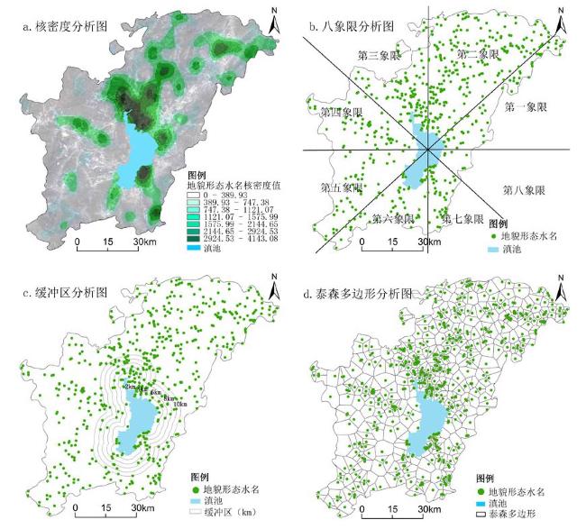
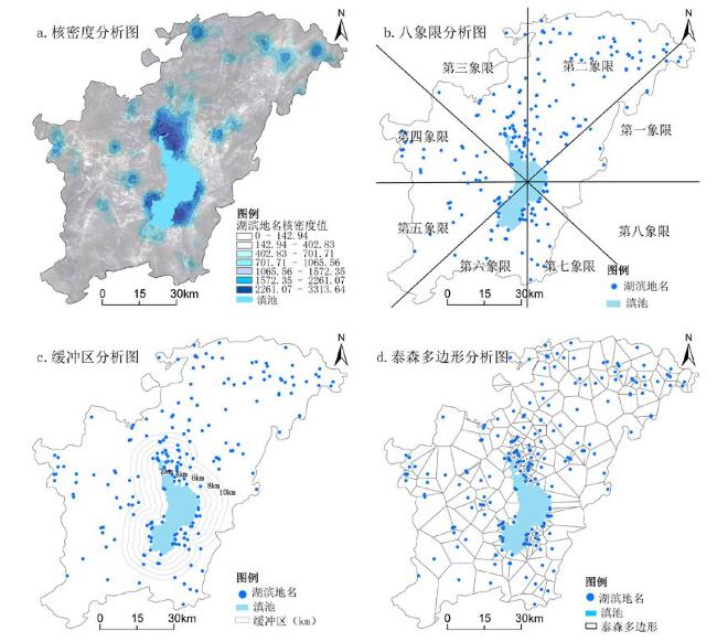
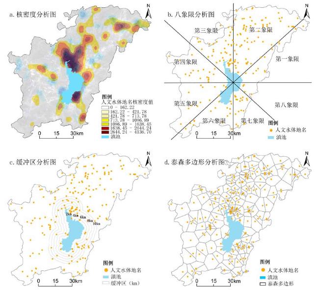
以环滇池1 006个乡村“涉水”地名为研究对象,通过量化统计分析,借助GIS中核密度分析、象限分析、缓冲区分析及泰森多边形分析,可视化分析地名文化景观,从而揭示乡村“涉水”地名文化景观的空间分布特征。研究表明:①乡村“涉水”地名分布反映自然地理环境特征,集中分布于滇池北岸、西南和南岸坝区的三角洲、山前冲积平原和缓坡地带,随海拔升高地名减少。②乡村“涉水”地名变化反映滇池水位的涨落,集中分布于滇池0~4 km范围内,距离滇池越近,人类依靠滇池从事生产、生活等相关活动越频繁。③乡村“涉水”地名来源一脉相承,以滇池为源,位于滇池北岸、东南岸和西南岸的坝区地名关系相互影响较大,与人口集中分布区吻合,乡村间往来密切,影响强度较深,但服务范围半径较短。
王涛 , 李君 , 陈长瑶 , 王海燕 , 李立晓 . 高原湖泊平坝区乡村“涉水”地名文化景观分析——以环滇池地区为例[J]. 经济地理, 2020 , 40(12) : 231 -239 . DOI: 10.15957/j.cnki.jjdl.2020.12.026
Taking 1 006 villages as research objects which are named after the element of water alongside Dianchi Lake area,this paper analyzes spatial distribution characteristics of cultural landscape of village toponym named after the element of water by the means of the quantitative statistical analysis,kernel density method,quadrant analysis method,buffer analysis method and Tyson polygon analysis method. The research shows that: 1) The distribution of village toponym named after the element of water reflects the characteristics of the natural geographical environment. It is concentrated in deltas,piedmont alluvial plains and gentle slopes in the northern,southwestern and southern of Dianchi Lake. The higher altitude,the less village toponym named after the element of water. 2) The change of the place name reflects the fluctuation of the water level in Dianchi Lake,which is mainly distributed in 0-4 kilometers of Dianchi Lake. The closer to Dianchi Lake,the more frequently humans rely on Dianchi Lake for related production and life activities. 3) The village toponym named after the element of water is deeply affected by Dianchi Lake,especially located on the northern,southeastern,and southwestern shores of Dianchi Lake,which coincides with the population distribution. The more contacts among villages,the deeper influence on the village toponym,but its influence radius is short.
表1 环滇池乡村“涉水”地名用字(词)分类及统计Tab.1 Classification and statistics of words in village toponym named after the element of water around the Dianchi Lake |
| 主类 | 亚类 | 主要用字(词) | 总数/个 | 比例/% |
|---|---|---|---|---|
| 自然水体类 | 地貌形 态水名 | 水、河、溪、江、源、涧、洼、沟、洪、濂、洗、洞、嘴、尾、浦、湾 | 587 | 58.35 |
| 湖滨名 | 海、潮、波、滩、滇、湖、渡、鱼、咀、漾、浪、潭、池、泉、边、螺蛳 | 211 | 20.97 | |
| 人文水体类 | 渔、塘、井、饮、船、坝、闸、田、洗、港、泊 | 208 | 20.68 | |
| [1] |
陈优良, 连伟海, 卞焕. 客家地名文化景观的空间分布特征及成因[J]. 测绘科学, 2019, 44(3):70-77.
|
| [2] |
朱竑, 周军, 王彬. 城市演进视角下的地名文化景观——以广州市荔湾区为例[J]. 地理研究, 2009, 28(3):829-837.
|
| [3] |
陈晨, 修春亮, 陈伟, 等. 基于GIS的北京地名文化景观空间分布特征及其成因[J]. 地理科学, 2014, 34(4):420-429.
|
| [4] |
林琳, 钟志平, 张洋, 等. 增城文化交汇区地名文化景观特征及其影响因素[J]. 城市问题, 2018(10):85-94.
|
| [5] |
王茜, 刘桂林, 齐秀静, 等. 保定市新住区地名文化景观的形式与内涵分析[J]. 安徽农业科学, 2010, 38(35):20144-20145.
|
| [6] |
王际桐. 论我国地名的命名原则[J]. 地球信息科学, 2001(3):13-17.
|
| [7] |
王洪波, 杨冉冉. 基于GIS的保定乡村地名文化景观分析[J]. 干旱区资源与环境, 2018, 32(11):99-105.
|
| [8] |
张春菊, 张雪英, 吉蕾静, 等. 地名通名与地理要素类型的关系映射[J]. 武汉大学学报:信息科学版, 2011, 36(7):857-861.
|
| [9] |
孙百生, 郭翠恩, 杨依天, 等. 基于GIS的承德乡村地名文化景观空间分布特征[J]. 地理科学, 2017, 37(2):244-251.
|
| [10] |
|
| [11] |
|
| [12] |
|
| [13] |
李建华, 米文宝, 冯翠月, 等. 基于GIS的宁夏中卫县地名文化景观分析[J]. 人文地理, 2011, 26(1):100-104.
|
| [14] |
王远, 李开宇, 方传珊. 基于GIS的渭南市地名地理环境要素分析[J]. 云南地理环境研究, 2017, 29(5):53-58,68.
|
| [15] |
王晓男, 李开宇, 王远, 等. 基于POI数据的街道地名地理环境要素分析——以西安市城六区为例[J]. 云南地理环境研究, 2018, 30(6):58-64.
|
| [16] |
王彬, 黄秀莲, 司徒尚纪. 广东政区地名文化景观研究[J]. 热带地理, 2011, 31(5):507-513.
|
| [17] |
宋晓英, 李文娟, 傅学庆, 等. 基于GIS的蔚县地名文化景观分析[J]. 干旱区资源与环境, 2015, 29(12):63-68.
|
| [18] |
|
| [19] |
王法辉, 王冠雄, 李小娟. 广西壮语地名分布于演化的GIS分析[J]. 地理研究, 2013, 32(3):487-496.
|
| [20] |
陈庆江. 文化视野下的云南历史地名[J]. 中国地名, 2015(12):48-53.
|
| [21] |
赵静, 张争胜, 陈冠琦, 等. 文化生态学视角下的南海诸岛地名文化[J]. 热带地理, 2016, 36(6):1045-1056.
|
| [22] |
梁艳. 山水视角下的古城赣州地名文化[J]. 中国地名, 2015(12):45-47.
|
| [23] |
刘灵坪. 明清以来滇池南缘地区的乡村聚落与人地关系[D]. 上海: 复旦大学, 2010.
|
| [24] |
吴光范. 昆明地名博览辞典[M]. 昆明: 云南人民出版社, 2005.
|
| [25] |
苏国有. 昆明密码——滇池区域地名探秘[M]. 昆明: 云南人民出版社, 2012.
|
| [26] |
姜转芳, 颉耀文, 李汝嫣, 等. 基于GIS的干旱区绿洲农村居民点格局演变研究:以甘肃河西地区为例[J]. 生态与农村环境学报, 2019(3):324-331.
|
| [27] |
戴忱. ArcGIS缓冲区分析支持下的城市规划用地布局环境适宜性分析[J]. 现代城市研究, 2013, 28(10):22-28.
|
| [28] |
陈长瑶, 李君, 张磊, 等. 环滇池地区城镇用地扩展特征及推进模式研究[J]. 云南师范大学学报:哲学社会科学版, 2018, 50(3):128-138.
|
| [29] |
曹竞文, 李淑杰, 齐鲁, 等. 基于泰森多边形的汪清县农村居民点空间分布特征及其影响因素[J]. 世界地质, 2019, 38(1):268-276.
|
| [30] |
陈长瑶. 环滇池地区城市空间演变及优化研究[D]. 长春: 东北师范大学, 2018.
|
/
| 〈 |
|
〉 |