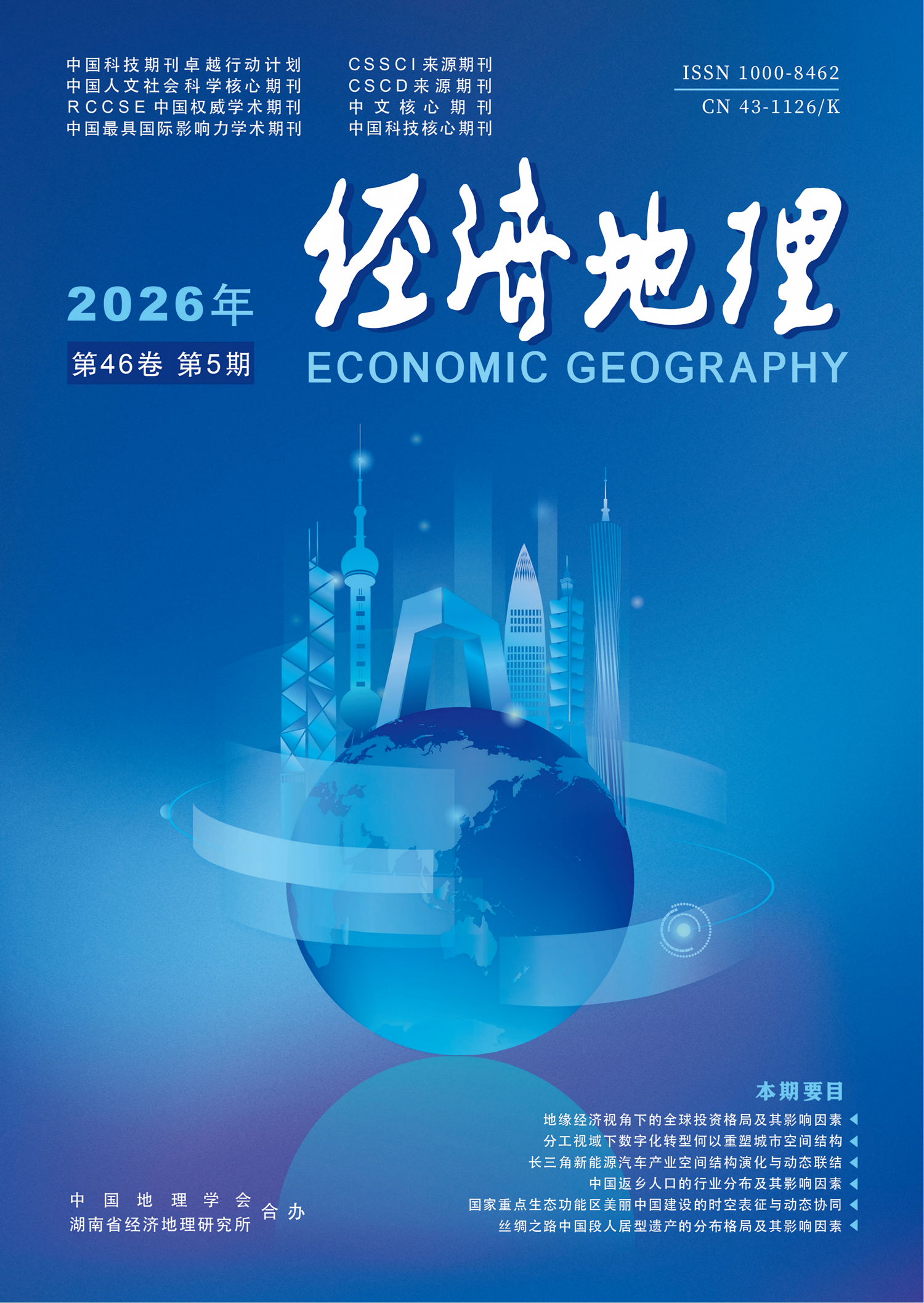
This article integrates the theories of the "strategic school" of geoeconomics (the state acts as an agent of economic power) and the "economic geography school" (the flow of economic factors and spatial reconstruction), and centers on the data of IMF's cross-border investment and the multi-source heterogeneous geospatial data from 2009 to 2023. Using the methods of HM index, social networks, spatial analysis, and Mantel test, it analyzes the spatiotemporal patterns, dependencies, network topology structure and geopolitical influences of global investment. The findings are as follows: 1) Global investment exhibits a phased development pattern, transitioning from rapid growth to oscillatory stability and eventually to minor decline, which is basically in line with the economic cycle. The investment pattern has undergone power transfer and spatial reconstruction, developed regions like Western Europe and North America are losing their dominant positions, while emerging economies such as China and India are rapidly increasing their influence in global investment networks. This has resulted in a tripartite spatial pattern involving North America, Western Europe and East Asia. 2) The topological features of the global investment network profoundly reflect the distribution and reorganization of geo-economic power. The global investment network shows a certain tendency towards factionalization and fragmentation. The intensity of investment dependence has generally increased, and the competitive and cooperative relationships in investment reflect the coexistence of the convergence and division of regional communities. The spatial gap between "supply" and "demand" of outward investment and foreign capital inflow continues to widen. The global investment network has entered a stage of structural adjustment characterized by the coexistence of factionalization and fragmentation. 3) The interdependencies of global investment are shaped by a combination of geopolitical factors, including the relative strengths and multidimensional proximities among nations. The influence of these factors varies across different investment contexts and time periods. Economic disparities, trade gaps, and resource endowment differences show positive correlations. Labor and business disparities exhibit weaker correlations. Geographic distance, once a significant inhibitor, has become less impactful. Shared languages and historical colonial ties demonstrate diminishing correlations, while the influence of institutional environment differences remains inconsistent. Investment policy environments have a relatively weak impact, which is further declining. Economic cooperation organizations, however, exhibit a strong positive correlation.
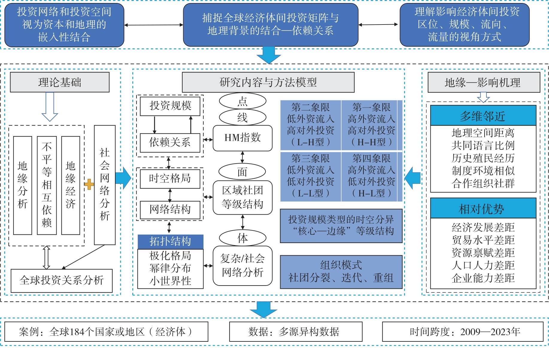
Based on the analysis of the coupling mechanism between new quality productive forces and residents' well-being, this paper constructed the theoretical framework of coupling coordination between them, and comprehensively used the coupling coordination degree model, the spatial autocorrelation analysis and the fuzzy-set qualitative comparative analysis to reveal the spatiotemporal evolution patterns and multiple concurrent driving paths of the coupling coordination between new quality productive forces and residents' well-being in China at the provincial level from 2013 to 2022. The results show that: 1) The development of the new quality productive forces and the residents' well-being in China are characterized by the coexistence of "stepwise progression" and "spatial polarization". The new quality productive forces show a pattern of "decreasing step by step from the east of China to the northwest of China", and the residents' well-being shows a pattern of "alternating high and low values from the east of China to the west of China". 2) The coupling coordination relationship has shifted from mild imbalance to barely coordinated, forming a "T-shaped" high-value continuous area superimposed along the Yangtze River Economic Belt and the coastal axis. There is a spatial positive correlation in the coupling coordination degree, showing a club convergence phenomenon. The high-value clusters spread gradually with the Yangtze River Delta as the center, and the low-value depressions are locked in the northeast, northwest, southwest of China and lower reaches of the Yellow River. 3) Single variable factors such as economic foundation, industrial structure and government regulation do not constitute sufficient and necessary conditions for the coupling coordination between new quality productive forces and residents' well-being. There are four configuration paths: the market-led dual-wheel drive development mode, the traditional synergy upgrading development mode, the capital-driven three-element symbiotic development mode and the urban-led multi-adaptation development mode.
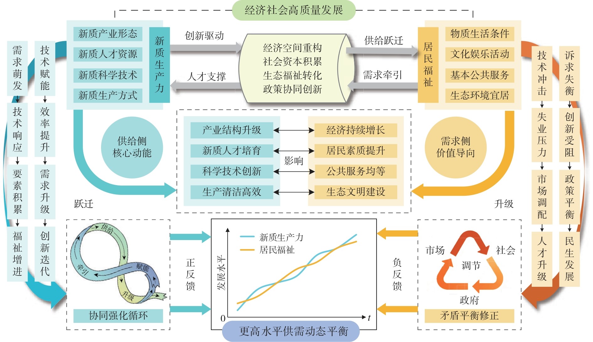
Based on the spatial correlation network data of China's inclusive green development from 2006 to 2022, this paper employs the methods of the social network analysis, the motif analysis and the dynamic exponential random graph models to systematically examine structural characteristics of its spatial correlation networks, deconstruct its intrinsic relationships between microscopic motif configurations and macroscopic connectivity patterns, and investigate its endogenous and exogenous driving forces in the dynamic evolution of the spatial correlation network. It's found that: 1) The spatial correlation network of China's inclusive green development exhibits the characteristics of increasing internal connections, high accessibility, and rising spatial integration, with significant "small-world" network characteristics. 2) The spatial correlation network of China's inclusive green development presents a macro-connectivity model of the "net spillover" sector ↔ "broker" sector ↔ "net benefit" sector. The micro-connectivity model is mainly driven by a chain structure and supplemented by a closed structure. 3) The formation and evolution of the spatial correlation network of China's inclusive green development is not random and exhibits a path-dependent effect. The endogenous driving effects of the reciprocity and transitive closure configurations in the network's self-organizing structure are significant, while the external driving forces (such as economic development level, industrial structure, and energy consumption intensity) have weakened. Geographic proximity spatial networks and digital economy spatial networks co-evolve with and mutually reinforce the spatial correlation network of China's inclusive green development.
Taking 2012-2022 as the research period and selecting 31 provincial-level regions in China as research samples, this study measures the spatial adaptation level between population aging and elderly care resources, and analyzes its spatiotemporal evolution characteristics, future development trends and influencing factors with the help of spatial autocorrelation, gray prediction, spatial lag model and other methods. The results show that: 1) The population aging is gradually deepening, most provincial-level regions are gradually changing to deep aging. At the same time, there are regional differences in the allocation level of elderly care resources, with higher allocation levels in the eastern and western regions, and lower allocation levels in the central and northeastern regions. 2) The overall level of spatial adaptation between population aging and elderly care resources is "stable with improvement", showing a spatial pattern dominated by the "east-west" direction, accompanied by local agglomeration characteristics. 3) Forecasts for the period 2023-2035 indicate that the spatial adaptation between population aging and elderly care resources will continue the previous development trend, but the provincial-level regions where the adaptation level continues to decline in the future deserve special attention. 4) The level of economic development, the level of urbanization, the industrial structure, the government financial expenditure and the demand for elderly care are important influencing factors of the spatial adaptation level between population aging and elderly care resources.
Clarifying how fiscal transparency affects the process of common prosperity is of great significance for the government to remedy the "shortcomings" of existing institutions. Based on the panel data of prefecture-level cities in China from 2013 to 2022, this paper empirically evaluates the multidimensional effects of fiscal transparency on common prosperity from the perspectives of local and neighboring areas. The findings show that: 1) From the local perspective, the improvement of local government fiscal transparency has effectively accelerated the process of common prosperity within the jurisdictions, which reflects in the dual enhancement of prosperity degree and commonality degree, while the improvement effect on commonality degree is superior to that of prosperity degree. Heterogeneity effect analysis reveals that fiscal transparency improvement exerts more significant positive effects in regions with high prosperity degree but low commonality degree. 2) Mechanism testing indicates that local government fiscal transparency promotes the "development effect" by encouraging governments to increase the scale and efficiency of people's livelihood expenditure, and exerts the "sharing effect" by strengthening primary distribution and redistribution of resources, thereby accelerating common prosperity. 3) From the neighboring perspective, the impact of fiscal transparency improvement on common prosperity has positive spatial spillover effects, but the significance is mainly reflected in adjacent regions, with geographical and economic distance decay effects on non-adjacent regions. The conclusions of this study provide insights for how governments reduce obstacles to common prosperity through the optimization of existing institutions.
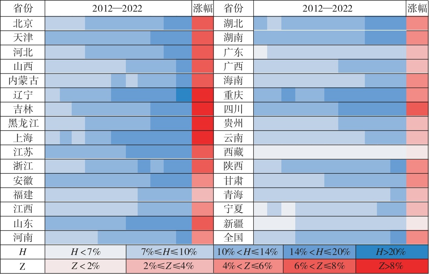
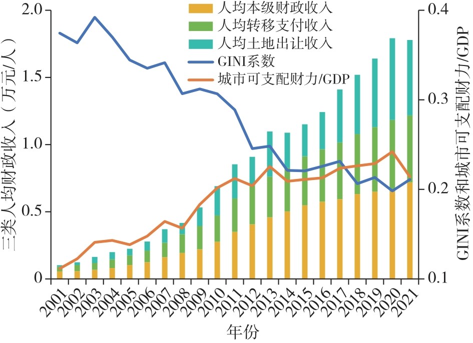
This study defines local governments' disposable fiscal resources as comprising three components: local fiscal revenue, government fund revenue, and intergovernmental transfer payments. Taking 280 prefecture-level and above cities of China as the research object and based on the long-term panel data in 2001-2021, this study systematically examines the spatiotemporal evolution characteristics and regional disparities of urban fiscal resources, and analyzes its main factors driving spatial differences in fiscal resources. The analytical methods include the Dagum Gini coefficient and its decomposition approach, as well as the Gini coefficient income decomposition method and the multiple linear regression model. The results show that: 1) The overall disparity in disposable fiscal resources among Chinese cities exhibits a convergence trend, and its spatial patterns align closely with the economic development level, forming a typical structure which is high value in the east of China, low value in the west of China, and lower value in central region. 2) Regional fiscal disparities mainly stem from interregional differences and hyper-variability density effects, while intraregional disparities contribute relatively little. 3) Local fiscal revenue and government fund revenue are the primary sources of overall fiscal disparities, and although intergovernmental transfer payments mitigate urban fiscal disparities and their adjustment effect is gradually strengthening, they remain insufficient to fundamentally reshape the regional fiscal landscape. 4) Economic development level, demographic and social structure, fiscal institutions and policy environment, as well as natural geography and locational conditions, all significantly influence urban fiscal resources and its evolution. Based on the above, this study proposes strategies such as continuing to deepen and optimize the reform of the intergovernmental transfer payment system, enhancing the precision and effectiveness of institutional design, so as to better reduce regional fiscal disparities and promote coordinated regional development.
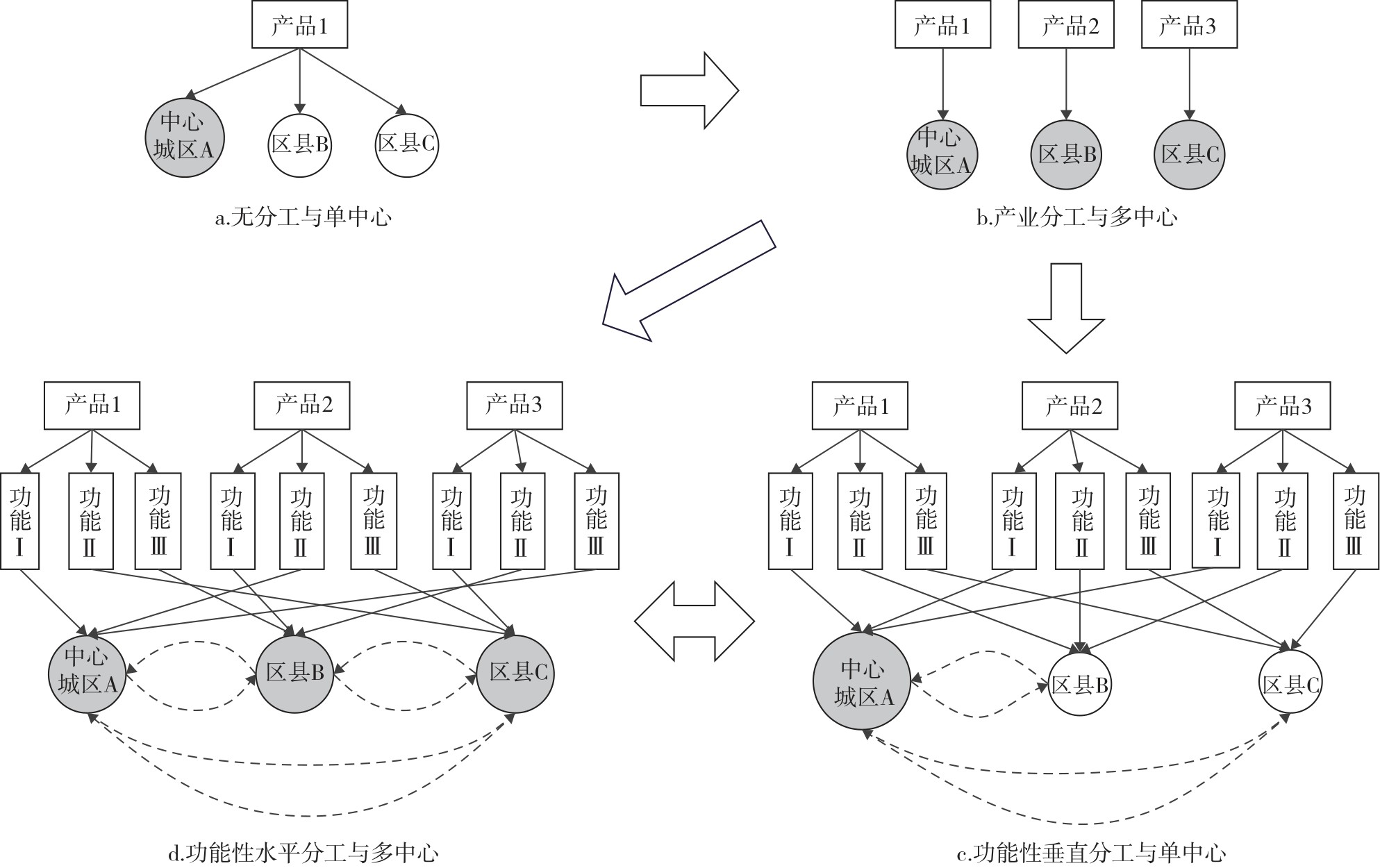
The evolution of urban spatial structure results from intra-city industrial relocation and the hierarchical differentiation of spatial functions, with the former reflecting industrial division of labor and the latter representing functional specialization. Drawing on the micro-level business registration data and the panel data from 283 prefecture-level cities in China from 2003 to 2020, this study empirically examines the impact of digital transformation and the deepening division of labor on the urban spatial structure. The findings show that: 1) Digital transformation facilitates both industrial and functional specialization by reducing transportation and transaction costs and enhancing returns to specialization, thereby reshaping the urban spatial structures. 2) The substantial fixed costs associated with digital transformation have intensified the "digital divide" between central and peripheral areas, steering functional specialization toward vertical rather than horizontal patterns. 3) This evolutionary trend has reinforced the dominance of central urban areas in industrial development and value distribution, contributing to the formation of a monocentric urban spatial structure. Therefore, promoting cost reduction and efficiency improvement in digital transformation and promoting horizontally structured functional specialization are essential for achieving a polycentric spatial structure spatial structure and advancing regional coordinated development.
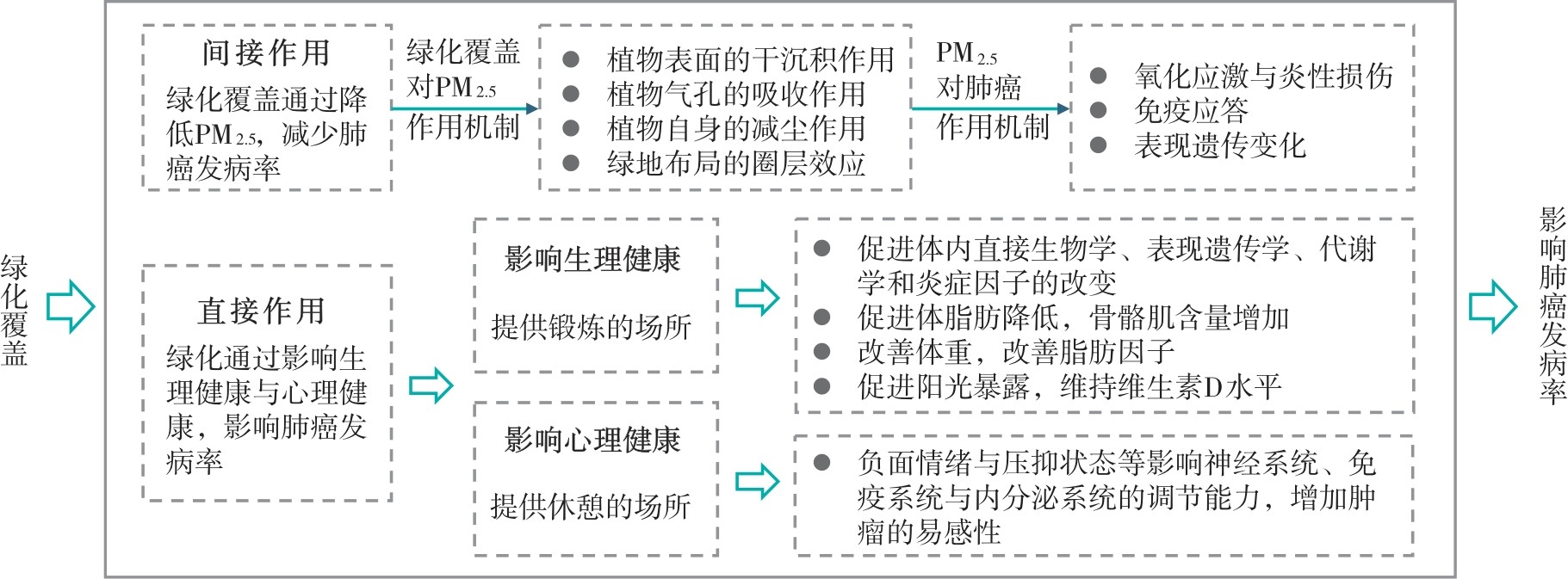
To elucidate the mechanism underlying the association between green coverage rate and lung cancer incidence, this study utilized the panel data on lung cancer, air pollution and built environment from the middle and lower reaches of the Yangtze River in 2013-2015 to investigate the impact mechanism and threshold effects of green coverage rate on lung cancer incidence based on the methods of a panel econometric model with fixed effects, mediation effect model and random forest model, it takes PM2.5 as a mediator. The results indicate that: 1) There is a significant negative correlation between green coverage rate and lung cancer incidence in the study region. Green coverage rate can reduce lung cancer incidence by lowering PM2.5 concentrations, with the mediating effect of PM2.5 reduction accounting for 47.17% of the total effect. 2) The relationship between green coverage rate and lung cancer incidence exhibits non-linear "U-shaped" pattern, indicating that moderate levels of green coverage are conducive to reducing lung cancer incidence, whereas the health benefits of excessively high green coverage are limited. Moreover, a specific threshold interval of green coverage rate exists, within which lung cancer incidence reaches its minimum level.
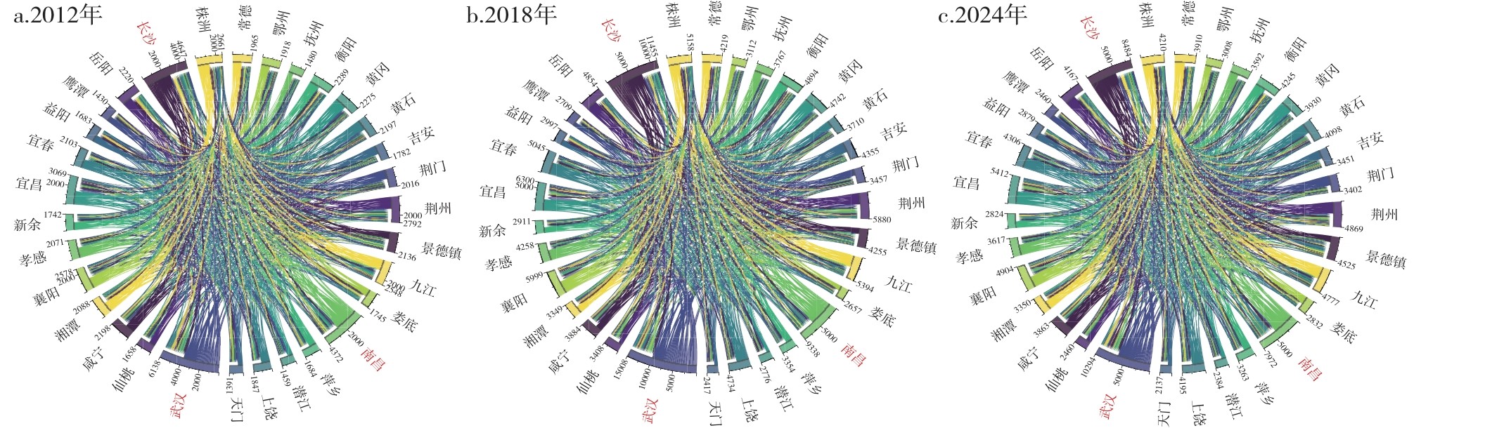
Based on the Baidu search query data to represent internet user attention connections between cities, this paper analyzes the evolution of the internet user attention network of urban agglomeration in the middle reaches of the Yangtze River from 2012 to 2024. Using the methods of city node analysis, network analysis, and relational network analysis, it analyzes the evolution characteristics of the internet user attention connection network among the cities in the middle reaches of the Yangtze River from 2012 to 2024, and examines the influence of multi-dimensional entity connections (such as population, enterprise and traffic) on the internet user attention connections, with a specific focus on the fundamental role of traffic connections. The results show that: 1) Internet user attention connections between nodes within the research area have strengthened over time. The spatial distribution of core nodes remains relatively stable, while the influence of provincial capitals continues to grow, with their spheres of influence expanding and overlapping. The node-size distribution is relatively balanced, showing an initial trend toward concentration followed by dispersion. 2) The internet user attention network forms a radial structure centered on the three provincial capitals. Cross-provincial connections continue to intensify, leading to a more balanced network. 3) The three subsidiary urban agglomerations show a trend of integration, with the Wuhan Metropolitan Area playing an increasingly prominent leading role. 4) Increases in population and traffic connections between cities significantly strengthen the internet user attention connections, with traffic connectivity playing a particularly fundamental role. Geographically proximate cities, as well as those within the same subsidiary urban agglomeration or dialect area, exhibit stronger internet user attention connections.
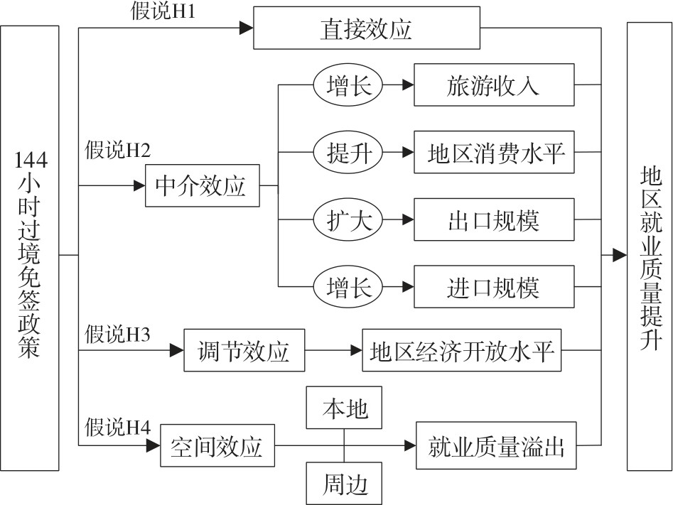
Based on the panel data of prefecture-level cities in China from 2005 to 2023, this paper systematically assesses the spatiotemporal effects and mechanisms of the 144-hour visa-free transit policy on regional employment quality by the means of the multi-period difference-in-differences model and the spatial Durbin model. The results show that: 1) As a significant initiative in China's pursuit of high-level opening-up, the 144-hour visa-free transit policy has generated a significant positive effect on regional employment quality, which remains robust after a series of robustness tests, including placebo tests, excluding the influence of other policies, and applying machine learning models. The policy effect is more pronounced in cities located in central and western regions, those with 5A-level scenic spots, a high proportion of the tertiary industry, a large population size. Moreover, the policy exerts a positive promoting effect on both manufacturing-dominant and non-manufacturing-dominant cities. 2) The policy enhances regional employment quality mainly by promoting growth in tourism revenue, boosting regional consumption levels, and expanding the scale of imports and exports. Additionally, the region's level of economic openness positively moderates the policy's effect on improving employment quality. 3) In terms of spatial effects, the policy's effect of enhancing regional employment quality not only presents a significant local effects, but also generates an obvious spatial spillover effect to regions with similar economic development levels.
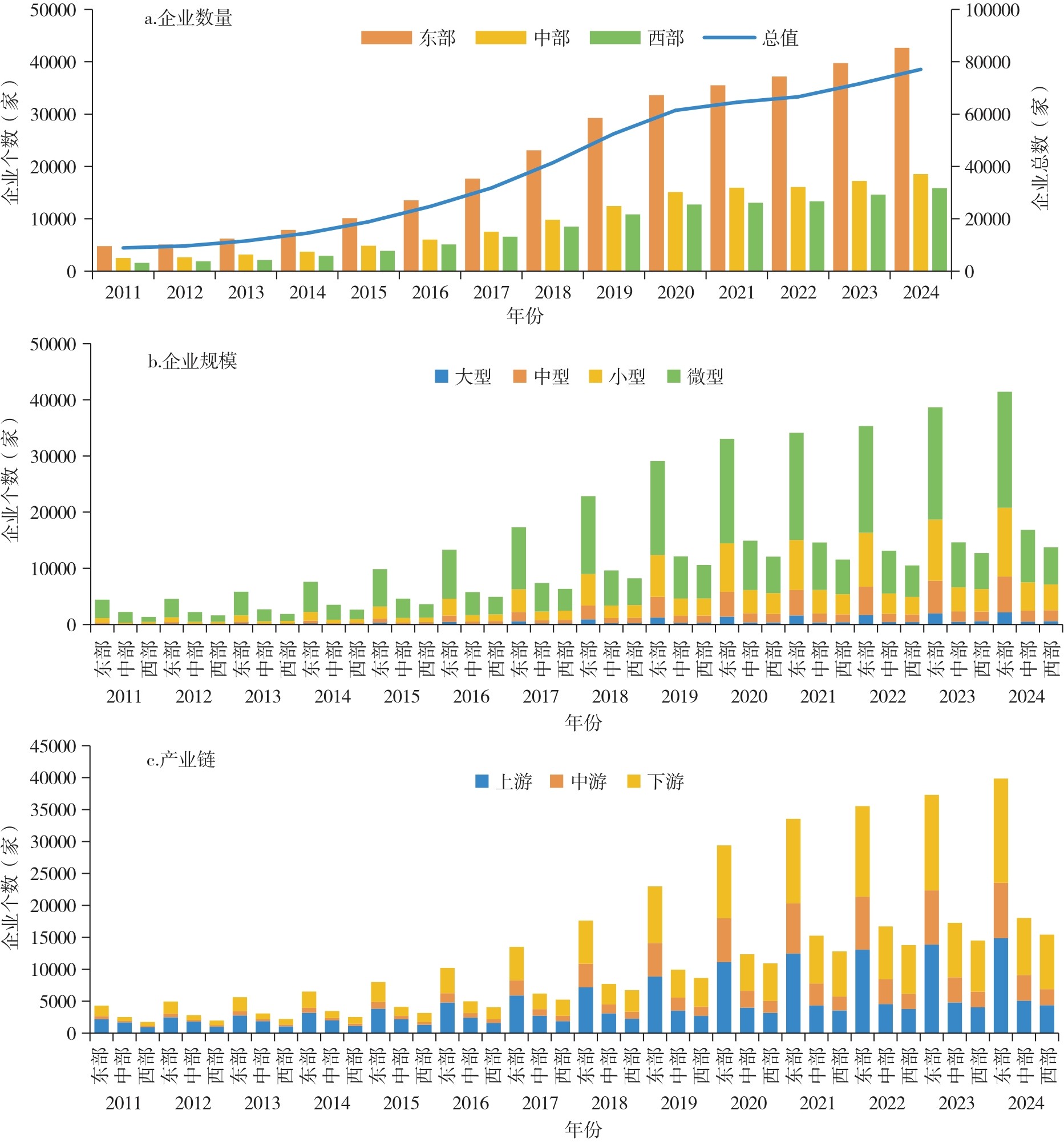
Taking China's low-altitude economy enterprises from 2011 to 2024 as the research object, this paper uses the kernel density estimation and the geographical detector to analyze their spatiotemporal patterns and influencing factors. The findings reveal that: 1) China's low-altitude economy enterprises expanded steadily, exhibiting an overall spatial distribution pattern of "high value in the eastern region, moderate value in the central region, and low value in the western region". Specifically, the eastern region is dominated by large and medium-sized enterprises, while the central region serves as a cluster for small and micro enterprises. 2) China's low-altitude economy enterprises display a spatial agglomeration structure of "three poles, multicores and axial belts", with accelerated agglomeration along the "T-shaped" axis of the eastern coast and the Yangtze River Economic Belt. 3) The spatial agglomeration characteristics of low-altitude economy enterprises of different scales are highly consistent, with the Guangdong-Hong Kong-Macao Greater Bay Area being the region with the highest agglomeration density. The spatial distribution of enterprises in the upstream, midstream, and downstream segments of the industrial chain are highly coordinated spatially, forming a complementary regional industrial system. 4) In terms of development stages, the driving mechanism of spatial distribution of low-altitude economy enterprises has shifted from the talent-led type to the technology-driven type, the interactive driving pattern has gradually transformed from one centered on the interplay between economic scale and human capital to one dominated by the interplay between innovation development and human capital. 5) Within the industrial chain, the interaction between economic scale and financial loans drive the entire chain. Nevertheless, the critical interaction factors vary significantly across different segments of the industrial chain. These findings provide a theoretical foundation and empirical reference for the spatial layout of low-altitude economy enterprises.
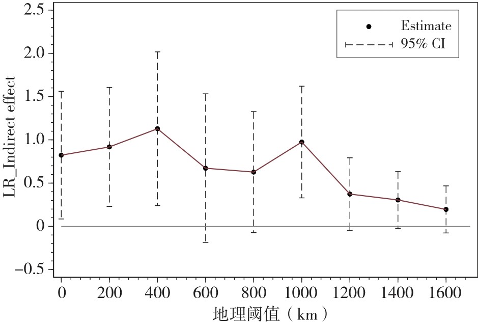
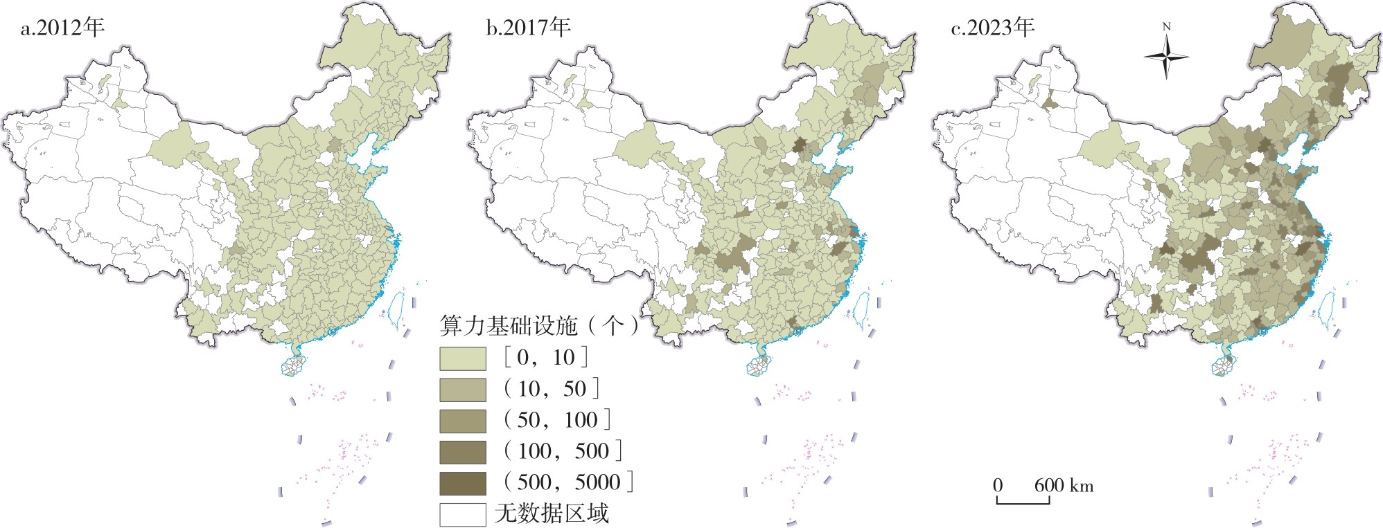
As a key foundation of the digital economy era, computing power infrastructure is of great significance in promoting disruptive technological innovation. Based on the panel data from 271 prefecture-level and above cities in China from 2012 to 2023, this article systematically examines the impact and pathway of computing power infrastructure on disruptive technological innovation. The results showed that: 1) Disruptive technological innovation and computing power infrastructure construction in China both exhibit an overall upward trend, with spatial heterogeneity, and the spatial development patterns of the two are similar. 2) The computing power infrastructure construction can significantly promote the disruptive technological innovation, and this effects are mainly achieved through expanding knowledge boundaries, optimizing the allocation of innovative elements, and reshaping research and development models. 3) In terms of heterogeneity, the promotional effect of computing power infrastructure is more pronounced in cities with greater policy support for innovation and more developed strategic emerging industries. 4) The computing power infrastructure construction has a significant positive spatial spillover effect on the disruptive technological innovation, but the impact of computing power infrastructure construction in central cities on the disruptive technological innovation in peripheral cities has a boundary effect, which is only evident within a 100km radius. These conclusions provide important policy references for optimizing the layout of computing power infrastructure and promoting the disruptive technological innovation.
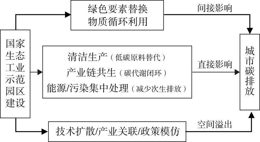
Taking the construction of national eco-industrial demonstration parks as a quasi-natural experiment, this paper employs the panel data from 281 prefecture-level cities in China from 2003 to 2024 to construct a multi-period difference-in-differences model to systematically investigate the impact of the construction of national eco-industrial parks on urban carbon emissions and its spatial effects. It's found that: 1) The construction of national eco-industrial demonstration parks significantly reduces total urban carbon emissions and exhibits a positive spatial spillover effect, contributing to lower carbon emissions in neighboring cities. Mechanism analysis indicates that the carbon emission reduction effect is achieved through two pathways: promoting the substitution of green factors and facilitating material circular utilization. Heterogeneity analysis further reveals that this emission reduction effect is more pronounced in non-resource-based cities, non-old-industrial-base cities, and cities with a high level of polycentric spatial structure. This paper provides empirical evidence and policy implications for improving the green governance system of industrial parks and optimizing the design of carbon emission reduction policy design.
From the perspective of a "flow-hierarchy" framework informed by network externalities, this study examines how intercity factor flows reshape the spatial hierarchy of the Yangtze River Delta, and constructs its composite evaluation system. It uses the entropy-weighted TOPSIS method to quantify the level of new energy vehicle development in 2017-2023. Base on three types of networks (automotive parts supply, intercity economic and trade linkages and green patent collaboration), it builds a Bayesian dynamic linkage model to analyze the influence of cities' network positions and linkage intensities on hierarchical evolution. The results indicate that: 1) Core cities in the Yangtze River Delta exert marked hierarchical driving effects and functional spillover effects on sub-core cities, rendering the core-periphery gradient more distinct. However, peripheral cities lag behind in hierarchical upgrading due to constraints of absorptive capacity and path dependence. 2) Cross-provincial corridors and intra-provincial multi-core linkages are simultaneously reinforced, the factor flows within the production chain, economic and trade chain, and innovation chains shift from unidirectional diffusion to multidirectional coupling, with enhanced interactions among network hubs driving the reallocation and re-agglomeration of resources across multiple poles. 3) The spatial pattern of the new energy vehicle industry in the Yangtze River Delta has evolved from a single-core pattern to a multi-center collaborative pattern, with more intense core-core interactions. Meanwhile, the dynamic linkage model reveals the coexistence mechanism of advantageous resource diffusion and structural differentiation: On the one hand, supporting collaboration and technology spillovers upgrade certain secondary nodes. On the other hand, some cities experience negative externalities of hierarchical solidification due to insufficient embeddedness and absorptive capacity. Overall, industrial factor flows not only promote hierarchical advancement in core cities but also, to some extent, inhibit the solidification trend in peripheral cities, giving rise to the spatial hierarchical evolution characteristic of "core-led growth with peripheral lag". This study provides both a theoretical foundation and policy implications for optimizing the new energy vehicle industrial network structure and enhancing regional coordinated regional development in the Yangtze River Delta.
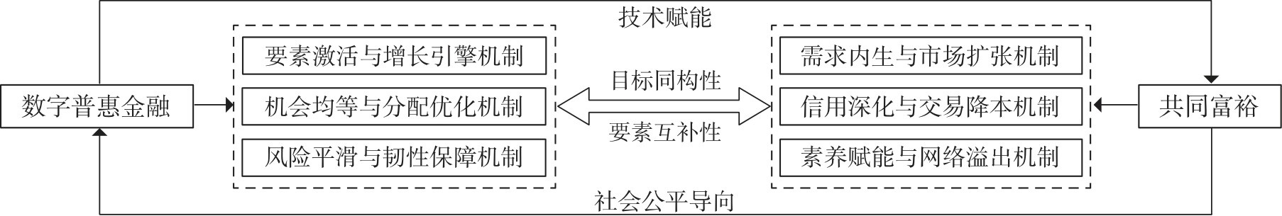
Based on the panel data of 30 provincial-level regions in China from 2011 to 2023, this paper uses the entropy weight method to measure the development levels of digital inclusive finance and common prosperity. Furthermore, it employs the methods of coupling coordination degree model, Kernel density estimation, and spatial Durbin model to explore the spatiotemporal characteristics and influencing factors of the coupling coordination relationships between digital inclusive finance and common prosperity. The research findings are as follows: 1) During the observation period, digital inclusive finance, common prosperity, and their coupling coordination degree all showed a steady upward trend, their coupling coordination relationships shifted from moderate imbalance type to primary coordination type. The overall difference in the coupling coordination degree between the eastern region and the central and western regions exhibited a downward trend year by year, and inter-regional imbalances have weakened to varying degrees. Notably, the eastern region has maintained a long-term leading position, remaining above the national average.2) There is a significant spatial correlation in the coupling coordination degree between digital inclusive finance and common prosperity. 3) Economic development, the level of traditional financial development, the level of digital industrialization, and the digital consumption market size have varying degrees of impact on the coupling coordination degree between digital inclusive finance and common prosperity.
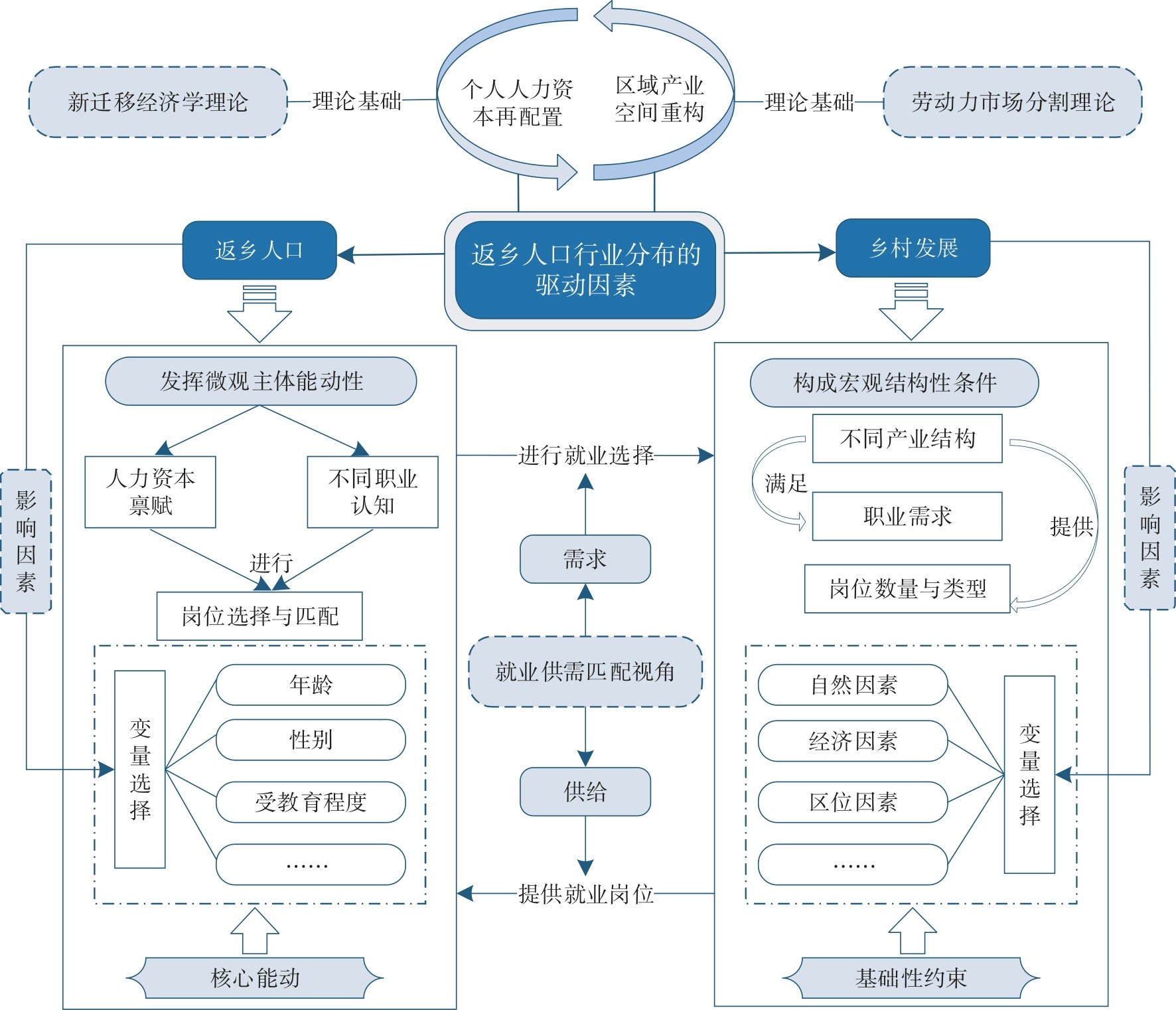
The return of populations to their hometowns contributes to the revitalization of talent and industrial innovation in rural areas. It has become a significant phenomenon that reshapes rural society in China and influences the development of urban and rural areas. Based on the data from the China Livelihood Survey in 2020 conducted by the Development Research Center of the State Council, this study analyzes the career transitions and employment choices of returning populations, and employs a Logistic regression model to identify the factors influencing industry distribution. It's found that: 1) The "corridor effect" of migrant workers' career transitions before and after returning to their hometowns is significant. Additionally, the occupational structure of non-agricultural workers who return to their hometowns shows high continuity with their pre-return occupation. 2) Returning individuals with lower education levels and older age are more likely to engage in agriculture upon returning to their hometowns. Their industry choice exhibits spatial coupling characteristics with regional advantageous industries. 3) The re-employment industry distribution of the returning population is influenced by various factors. Young, highly educated male laborers are more likely to be employed in the non-agricultural secondary industry. The per capita arable land and per capita construction land in rural areas have a significant impact on the returned population's engagement in the secondary industry within non-agricultural employment, while topography and city size have a greater impact on their engagement in the tertiary industry within non-agricultural employment. The findings of this study enhance the understanding of the employment selection mechanisms among returning populations and provide insights for the development of a people-land-industry coordination model in rural areas.
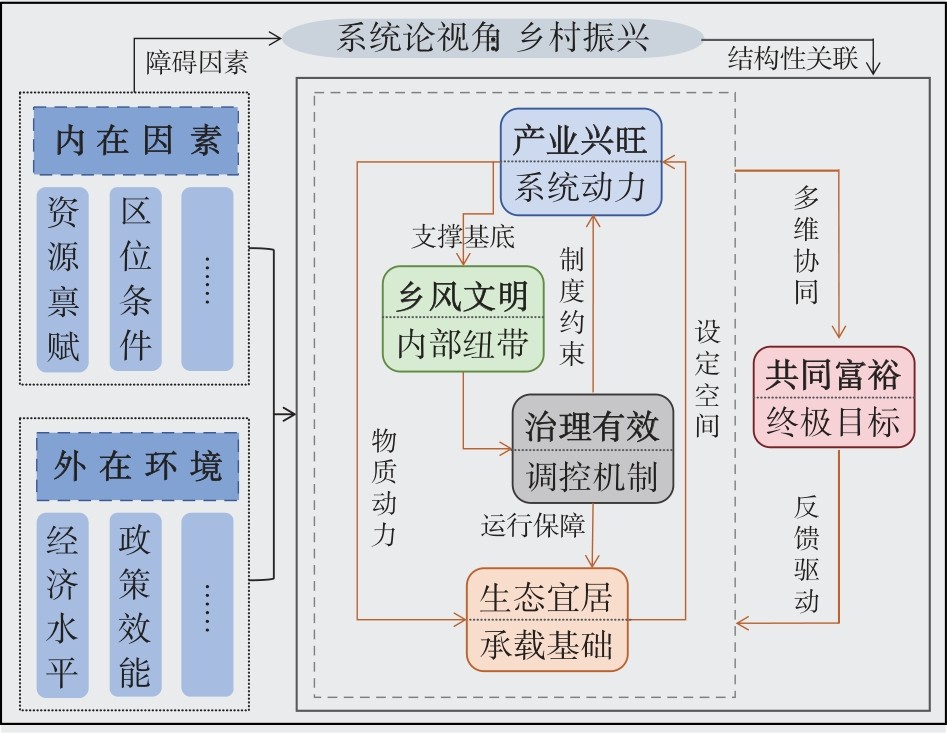
This article constructs an evaluation index system for rural revitalization and measures its development level of 30 provincial-level regions in China from 2008 to 2023 using the entropy weight method. It depicts the spatial correlation pattern of rural revitalization through spatial autocorrelation, and reveals its key obstacle factors and structural correlations between the criterion layers through the obstacle degree and structural equation model. The results show that: 1) From 2008 to 2023, the level of rural revitalization in China increased from 0.201 to 0.399, with an average annual growth rate of 4.696%, and presented a gradient distribution pattern of "high value in the east of China and low value in the west of China, high value in the south of China and low value in the north of China" and a spatial structure characterized by an interweaving of "point-belt-patch". 2) From the perspective of spatial evolution, the global Moran index value ranges from 0.125 to 0.169, showing significant spatial positive correlation. 3) At the criterion layer, the obstacle degrees of industrial prosperity, ecological livability, rural culture and civilization, effective governance, and common prosperity are respectively 25.867%, 21.263%, 17.913%, 23.467%, and 11.490%. Among them, industrial prosperity is the main bottleneck in the eastern and central regions, while insufficient governance efficiency restricts the development of the western region. At the indicator layer, agricultural science and technology transformation, rural greening, and agricultural production capacity are the current core obstacles of rural revitalization. 4) Rural revitalization takes common prosperity as the core link, forming extensive correlations with industrial prosperity, ecological livability, effective governance, and rural culture and civilization. However, it is worth noting that rural culture and civilization has a certain hindering effect on the improvement of common prosperity and ecological livability. In the future, it should pay more attention to key obstacle factors, strengthening agricultural scientific and technological innovation and green development, promoting the coordinated development of rural revitalization among regions, helping to achieve national overall balanced development, and realizing the second centenary goal.
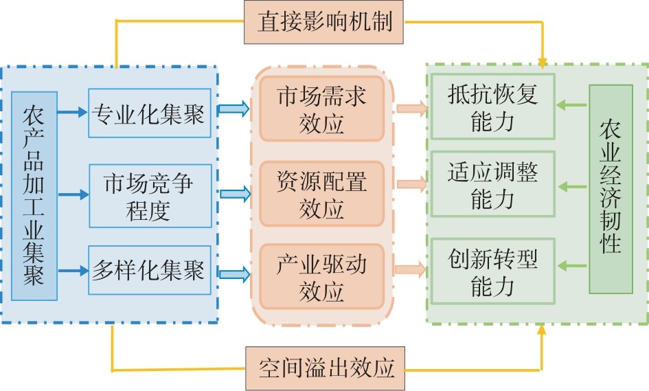
Based on the panel data of 31 provincial-level regions in China from 2007 to 2024, this paper constructs a comprehensive index system for the resilience of regional agricultural economy from three dimensions: resistance and recovery capability, adaptation and adjustment capacity, and innovative and transformation capacity. Using the Spatial Durbin Model (SDM), this paper explores the spatial effects and heterogeneity of agricultural product processing industry agglomeration and its different agglomeration patterns on the resilience of agricultural economy. The results show that: 1) Agricultural product processing industry agglomeration in China enhances the resilience of agricultural economy and exerts a positive spatial spillover effect, with the strongest influence on adaptation and adjustment capacity. 2) Specialized agglomeration and market competition intensity have significantly negative direct effects and spatial spillover effects on the resilience of agricultural economy, in contrast, diversified agglomeration generates positive effects and spillover effects. 3) Heterogeneity analysis shows that the impacts of agricultural product processing industry agglomeration on the resilience of agricultural economy present prominent industrial and regional heterogeneity. Based on the above findings, this paper puts forward references and policy implications for optimizing the spatial layout of regional agricultural product processing industry, boosting the resilience of agricultural economy, and advancing agricultural modernization driven by agricultural product processingindustrial agglomeration.
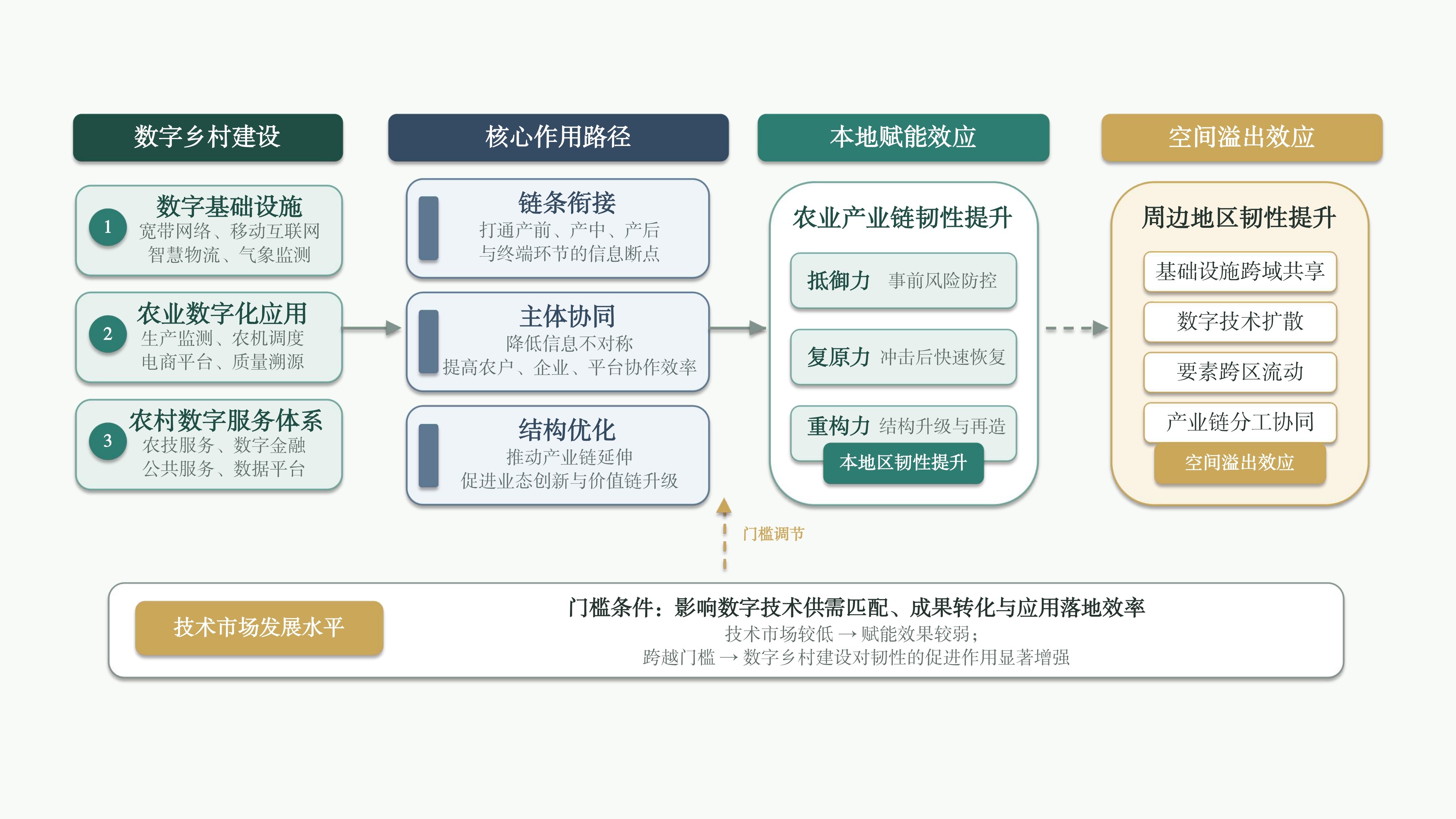
Based on the panel data from 30 provincial-level regions in China (2011-2022), this paper measures the level of digital rural construction and the agricultural industrial chain resilience using the entropy method, and employs the spatial Durbin model and threshold effect model to systematically examine the impact effects, spatial spillover characteristics, and threshold mechanisms of digital rural construction on agricultural industrial chain resilience. The results show that: 1) During the sample period, the level of China's agricultural industrial chain resilience generally increased, exhibiting a spatial pattern of "high value in the eastern region and low value in the western region" along with certain spatial agglomeration characteristics. 2) Digital rural construction significantly improves the agricultural industrial chain resilience and generates positive spatial spillover effects, indicating that it not only enhances the local resilience but also promotes resilience in neighboring regions through spatial linkages. 3) The impact of digital rural construction exhibits regional heterogeneity. Its direct promoting effect is significant in major grain-producing areas, while it is not significant in non-major grain-producing areas. However, both types of regions exhibit significant positive spatial spillover effects. 4) The development level of the technology market acts as a threshold constraint in the relationship between digital rural construction and agricultural industrial chain resilience. Only when the technology market development level crosses a relatively high threshold does the promoting effect of digital rural construction on agricultural industry chain resilience become significantly released. The findings suggest that digital rural construction should be promoted in a coordinated manner, interregional digital collaboration should be strengthened, differentiated digital empowerment strategies should be implemented according to local conditions, and the technology market should be cultivated more rapidly, so as to more fully unleash the empowering effect of digital rural construction on agricultural industrial chain resilience.
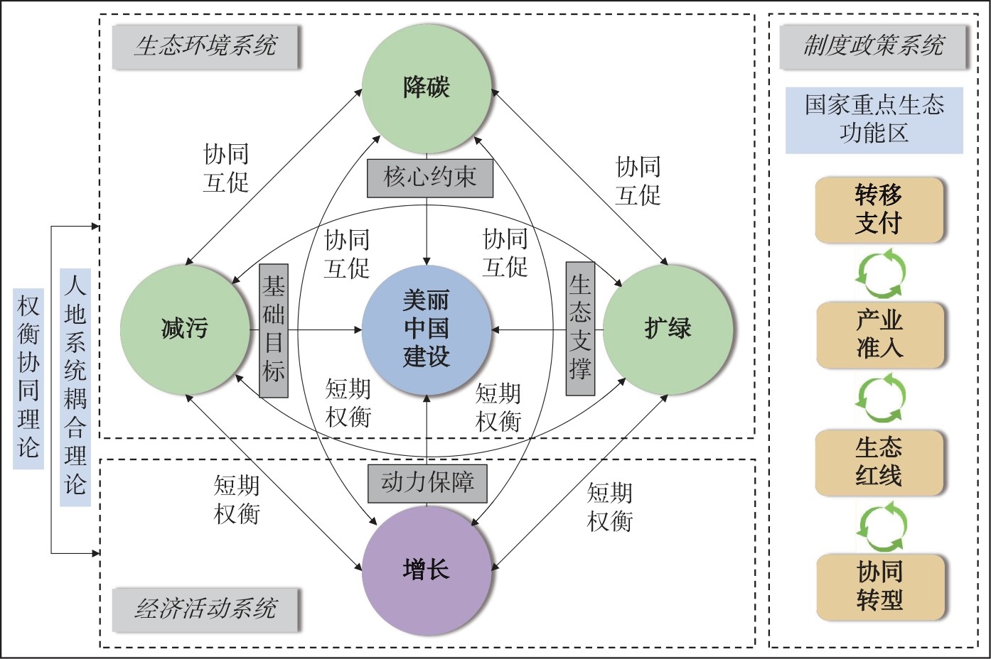
National Key Ecological Function Zones serve as critical spatial carriers for the Beautiful China Initiative. The policy framework of coordinated advancement of carbon reduction, pollution mitigation, green expansion, and economic growth offers a new perspective for the quantitative characterization and dynamic synergy analysis of Beautiful China Initiative. Drawing on the multi-source remote sensing imagery and statistical data, this study constructs the Beautiful China Initiative Index (BCII) at the county level and examines the synergistic characteristics of the "carbon reduction, pollution mitigation, green expansion and economic growth" from both spatial and temporal dimensions. The findings are as follows: 1) The BCII exhibits a U-shaped evolutionary trajectory with 2012 as a critical turning point. Significant spatial agglomeration is observed at the county scale, characterized by a pronounced gradient of "higher in the east and south of the research area and lower in the west and north of the research area". National Key Ecological Function Zones in the Yangtze River Delta, the Pearl River Delta, and Hainan Island emerge as high-value agglomeration areas, whereas those in the northwestern frontier regions are predominantly low-value areas. 2) From the perspective of spatial synergy, coordination among ecological-environmental factors (carbon reduction, pollution mitigation, and green expansion) is generally stronger than that between economic growth and these factors. Spatial units exhibiting high-level synergy in the three relationships involving economic growth account for less than 5% of the total, with most regions remaining in states of spatial non-synergy or low-level synergy. 3) From the perspective of temporal synergy, pairwise interactions among ecological-environmental factors are dominated by bidirectional synergy relationships (carbon reduction with pollution mitigation and carbon reduction with green expansion). In contrast, substantial heterogeneity exists in the coordination between economic growth and ecological-environmental factors, the bidirectional non-synergistic relationship between economic growth and carbon reduction requires resolution. The overall synergy among all four factors shows a steady upward trend. This study advances scientific understanding of the internal synergistic evolution of Beautiful China Initiative and provides empirical evidence to support differentiated policy implementation and regional coordination strategies for National Key Ecological Function Zones.
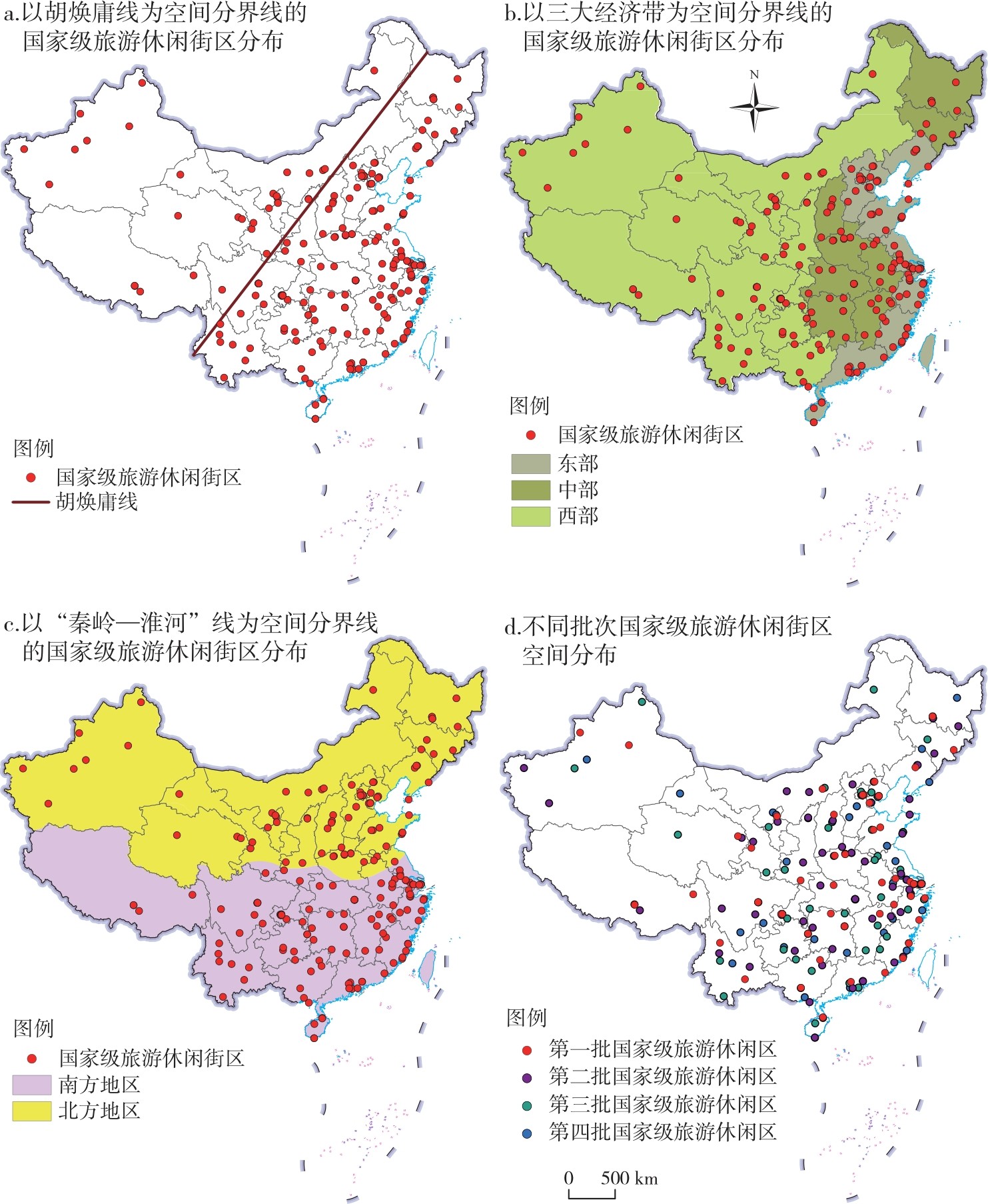
National-level tourist and leisure districts serve as important spatial carriers for the integrated development of culture and tourism in urban leisure consumption scenarios. Taking 204 national-level tourist and leisure districts in China as research objects, this paper analyzes their spatial distribution characteristics and influencing factors using the methods of the geographical concentration index, imbalance index, geographical detector. The results show that: 1) In terms of spatiotemporal pattern, national-level tourist and leisure districts exhibit spatial heterogeneity, and present the characteristics of core agglomeration, local diffusion, and global expansion across four batches. 2) In terms of spatial equilibrium, national-level tourist and leisure districts are concentrated at the provincial level, with significant inter-provincial differences, strong spatial correlation, and an overall agglomeration feature. 3) In terms of distribution density, national-level tourist and leisure districts are characterized by multi-core agglomeration and gradient differentiation, forming a hierarchical structure dominated by two high-density core areas, supported by multiple secondary high-density areas, and accompanied by several local agglomeration areas. 4) In terms of influencing factors, natural and humanistic factors jointly affect the spatial distribution pattern of national-level tourist and leisure districts. Among them, plain-hilly terrain with proximity to rivers, low altitude, and favorable hydrothermal conditions, as well as subtropical-warm temperate humid climate, form the fundamental natural constraints and supporting factors for the formation and development of the districts, providing a spatial carrier for the integrated development of culture and tourism. Tourism development level, transportation conditions, and government support are the core driving factors, which inject impetus into the practice of cultural and tourism integration in the districts by promoting the coupling of cultural and tourism formats and ensuring the flow of cultural and tourism elements.
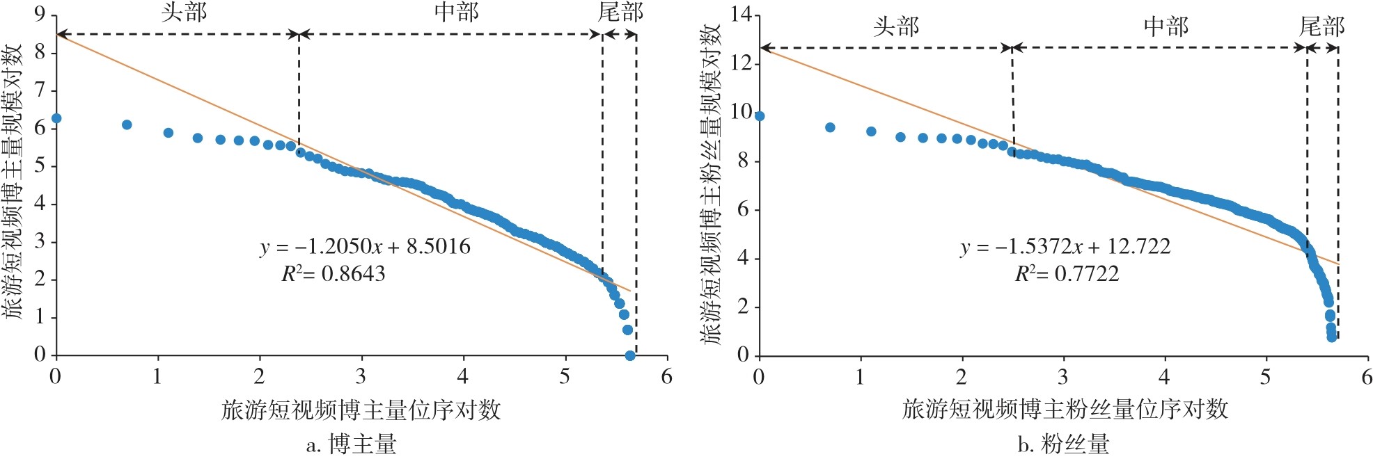
Travel short-video bloggers are a key force in promoting the development of regional tourism. Taking travel short-video bloggers of the Douyin as the research object, this paper uses the rank-size rule, GIS spatial analysis technology, and the optimal parameter geographical detector to explore the spatial distribution characteristics and influencing factors of travel short-video bloggers in Chinese cities. The research findings are as follows: 1) From the perspective of rank-size, the number of travel short-video bloggers and their followers conform to the rank-size rule, presenting an unbalanced state of "concentration at the top of curve and differentiation in the middle of curve and at the bottom of curve". 2) From the perspective of spatial differentiation, it shows the distribution pattern, which is dense in the southeast of research area and sparse in the northwest of research area along the "Hu Huanyong Line", with hotspots mainly concentrated in the Beijing-Tianjin-Hebei Urban Agglomeration, the Yangtze River Delta Urban Agglomeration, and the Chengdu-Chongqing Urban Agglomeration. Moreover, the proportion of second- and third-tier cities has significantly increased, breaking the traditional rule that the creative industry is highly concentrated in first-tier cities. 3) From the perspective of type distribution, celebrity bloggers are highly concentrated in regions which are rich in cultural and tourism resources, ordinary bloggers are widely distributed and mostly located in areas with a relaxed creative environment, and official bloggers are concentrated in first-tier cities with strong resource integration capabilities. 4) From the perspective of influencing factors, the network development level, the cultural and tourism resource endowment, the human capital support, and the policy environment support all have a positive impact on the spatial distribution of travel short-video bloggers, and the influence effect increases after the interaction of two factors. Among them, the interaction effect of the network development level with other factors is particularly prominent.
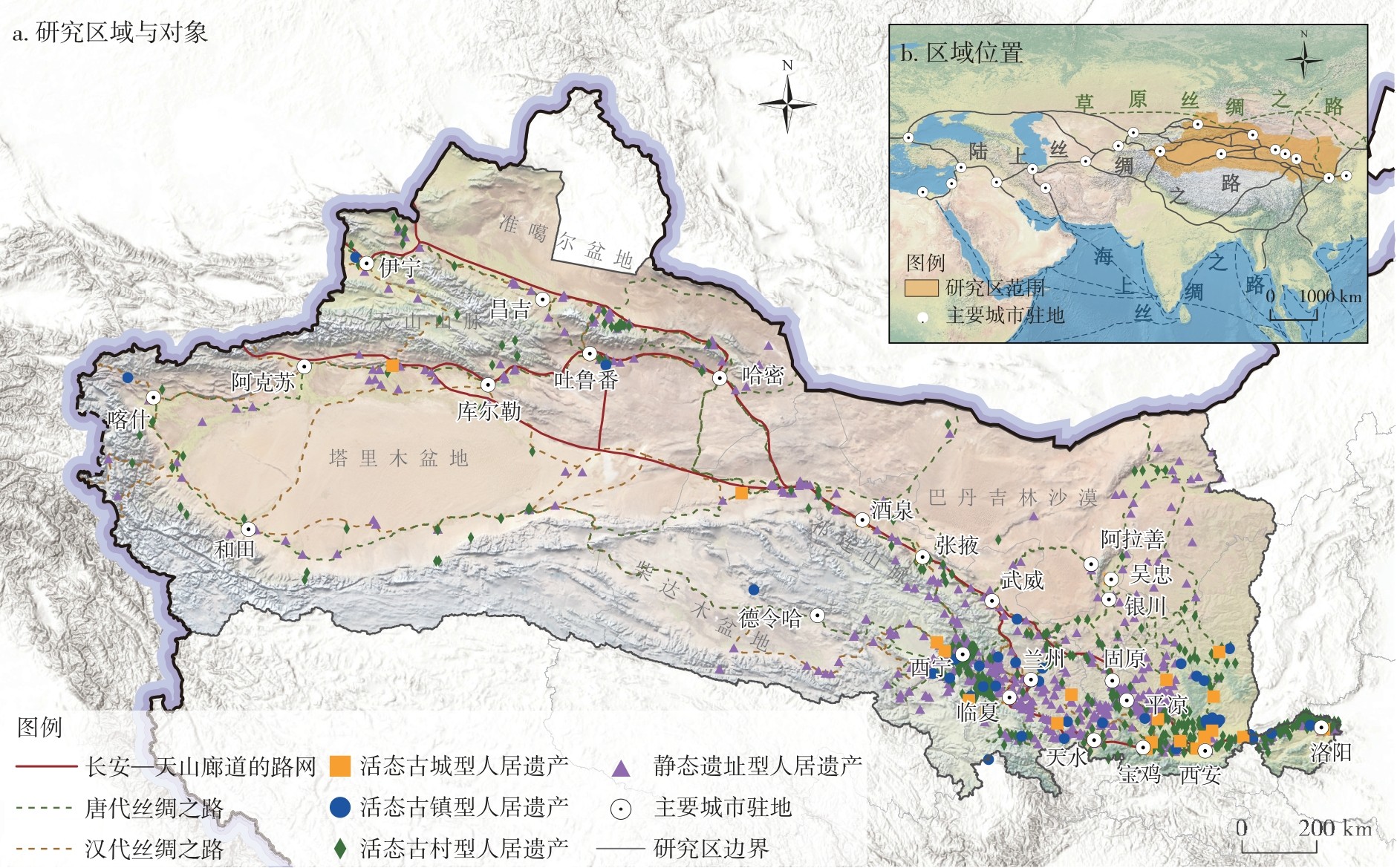
This study establishes a typology of inhabited heritage settlements, comprising two categories (living inhabited heritage and ruin-type inhabited heritage) and four types (living ancient cities, living ancient towns, living ancient villages, and static sites). Guided by a four-dimensional analytical framework (People-Event-Time-Space), this study uses the methods of spatial analysis and interpretable machine learning to characterize the spatial distribution patterns and analyze the multi-factor driving mechanisms. The results indicate that: 1) Inhabited heritage settlements exhibit an overall pattern of "dense in the east of the research area, sparse in the west of the research area, and clustered along corridors of the research area", with significant differences in spatial patterns among subtypes. Living ancient cities and living ancient towns show a "point-axis extension with hinterland dependence" structure, living ancient villages exhibit clustered distribution pattern, static sites demonstrate a multi-core and belt-like network. 2) Natural geographical factors form the foundational constraints, following a "hydrology-topography-ecology" tripartite logic. Living inhabited heritage settlements prefer river basin hinterlands and arable soils, reflecting a "resource-dependent and ecologically adaptive" mechanism. In contrast, ruin-type inhabited heritage settlements are often located in ecological marginal zones, characterized by distance from water sources and localized elevation control, mirroring historical processes of environmental change and settlement abandonment. 3) Humanistic and social factors drive spatial evolution through institutional, economic, and cultural pathways. Administrative establishment and state-sponsored migration under historical geopolitical strategies laid the settlement skeleton, commercial circulation and market effects enhanced the corridor-based agglomeration of settlement nodes, while technology diffusion and cultural transmission improved the ecological adaptability and social stability of the settlements.
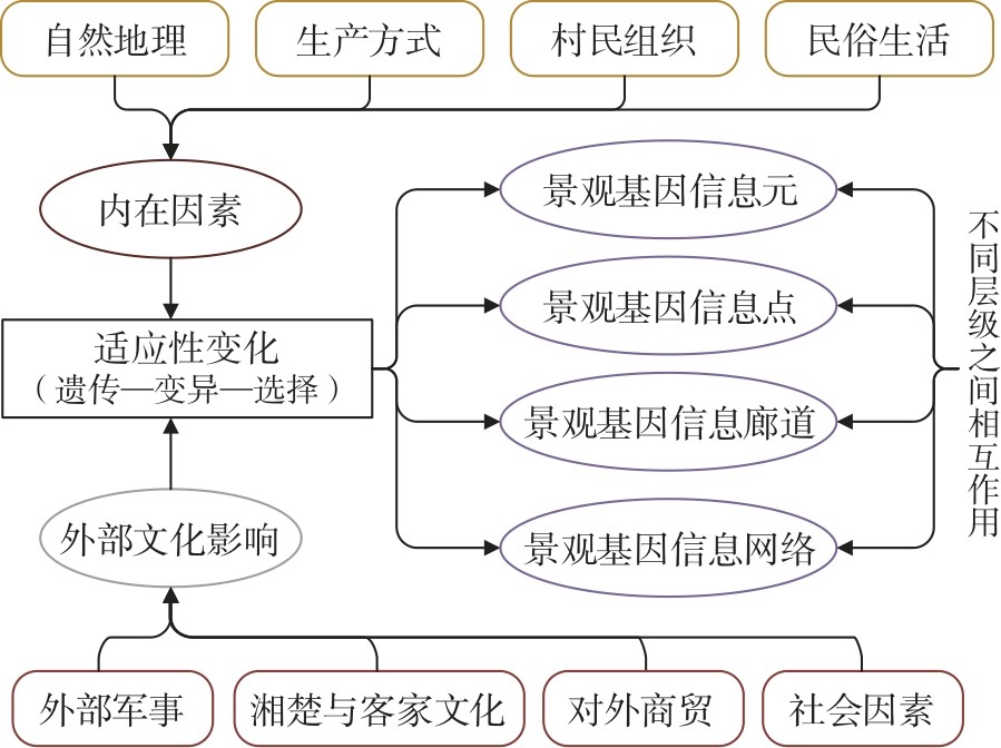
Based on the theory of landscape genes and taking traditional villages of Sanshui District in Foshan City as the research object, this paper constructs a four-level analytical framework consisting of "information element, information point, information corridor and information network" relying on the methods of field research, local literature, and digital technology. From the perspective of water environment adaptability, it analyzes the characteristics and formation mechanisms of village landscape genes. The findings are as follows: 1) It identifies and verifies the existence of a four-dimensional composite landscape gene system in the traditional villages of Sanshui District, characterized by "defense-commerce-ecology-production", which exhibits significant water environment adaptability. 2) The dominant landscape gene types vary across different villages, and they undergo adaptive evolution through spatial adaptation and knowledge coding under the four driving forces of natural constraints, economic forms, historical changes, and cultural integration. 3) The analytical framework of "information element, information point, information corridor and information network" effectively interprets the mechanism by which water environment elements are embedded at different levels and shape the village landscape. The research results provide theoretical basis and methodological support for the living conservation of water environment-adaptive traditional villages.