
Gradient Differences of Urban Development Regarding the Impact of Urban Spatial Form on the Intensity of the Urban Heat Island: A Case Study for Hefei City
Received date: 2025-07-25
Revised date: 2025-11-24
Online published: 2026-02-12
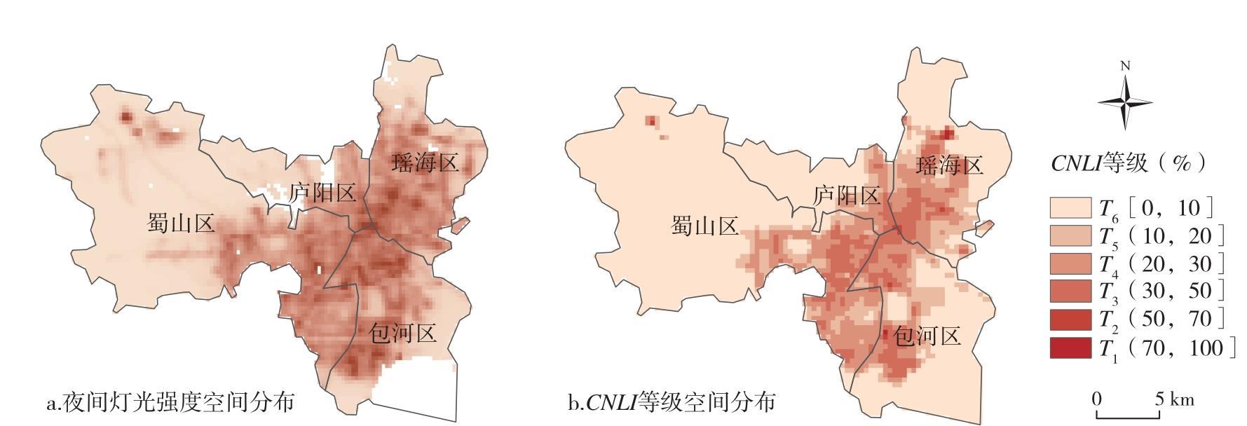
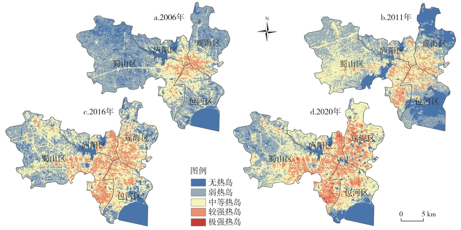
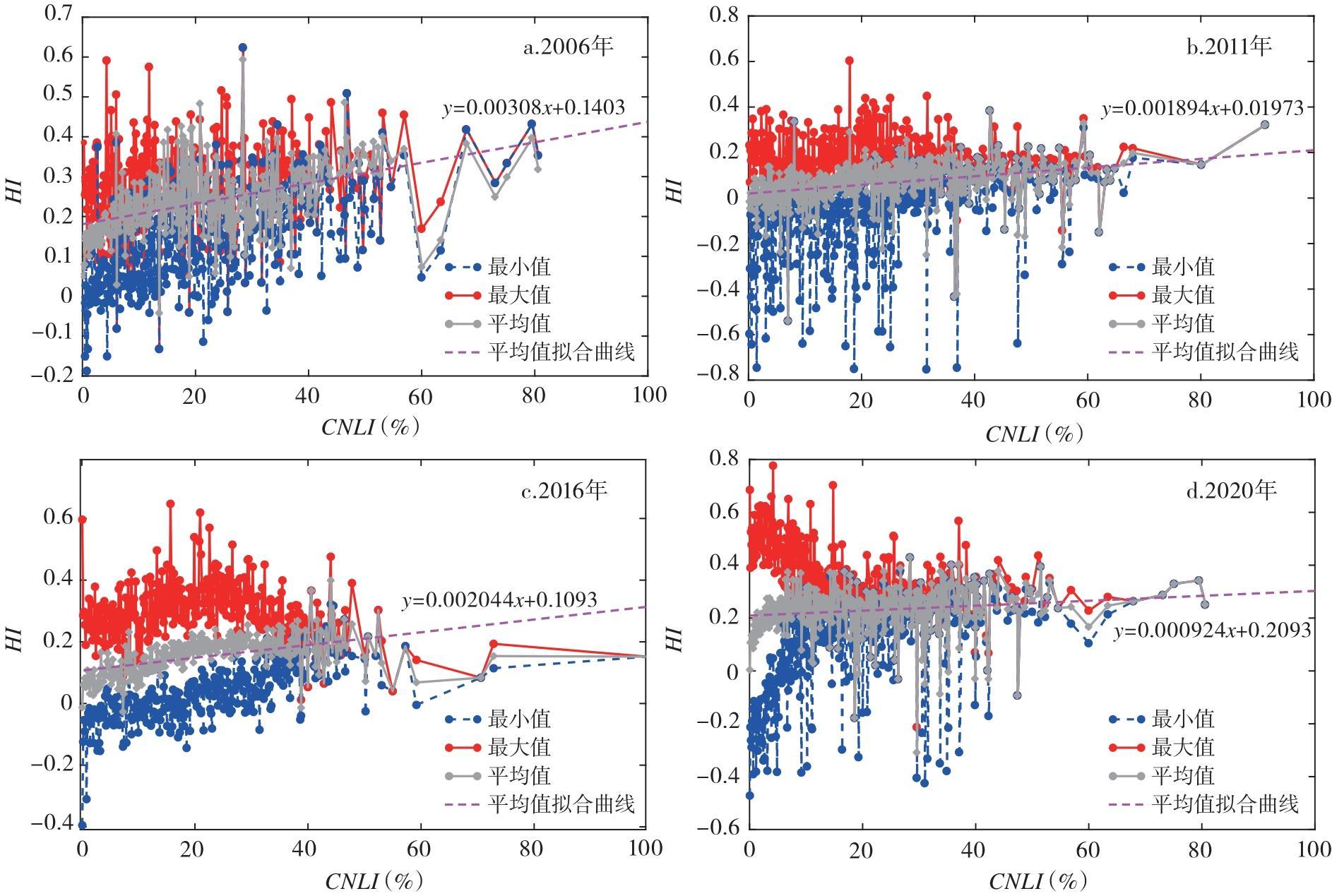
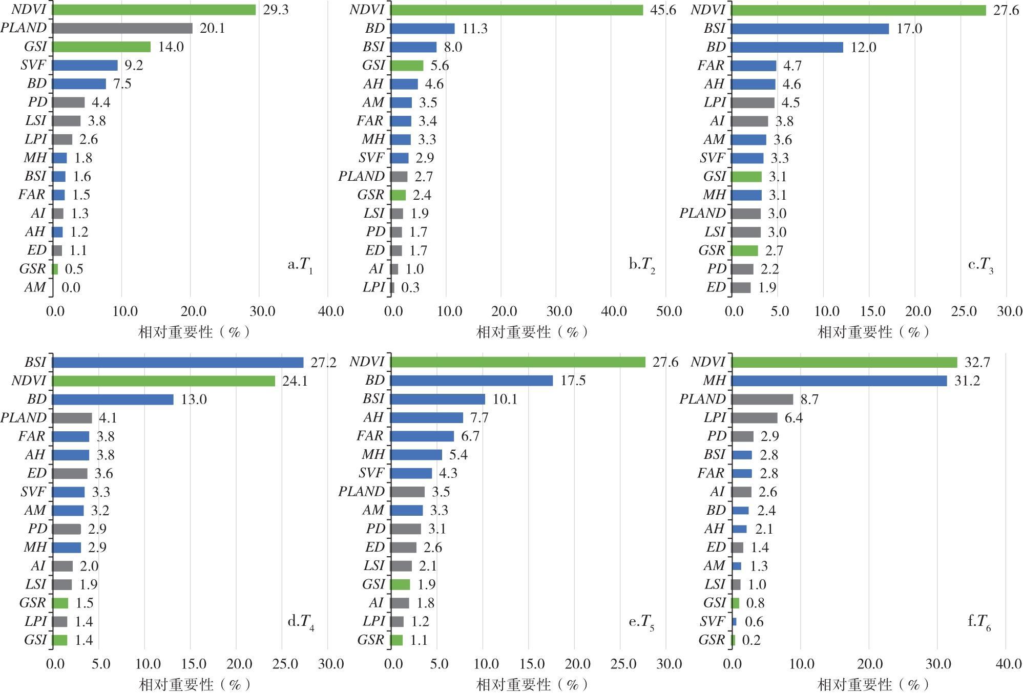
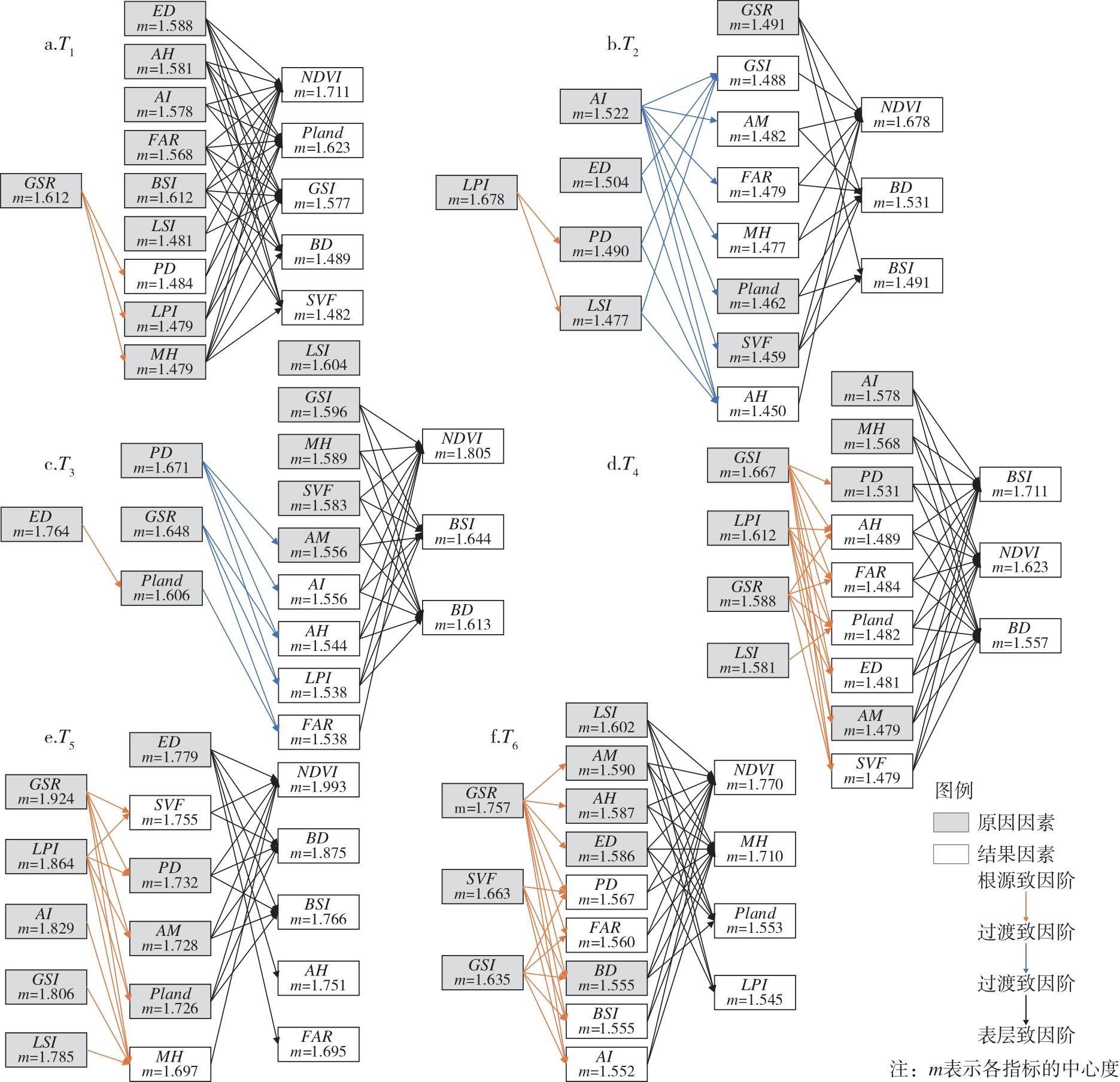
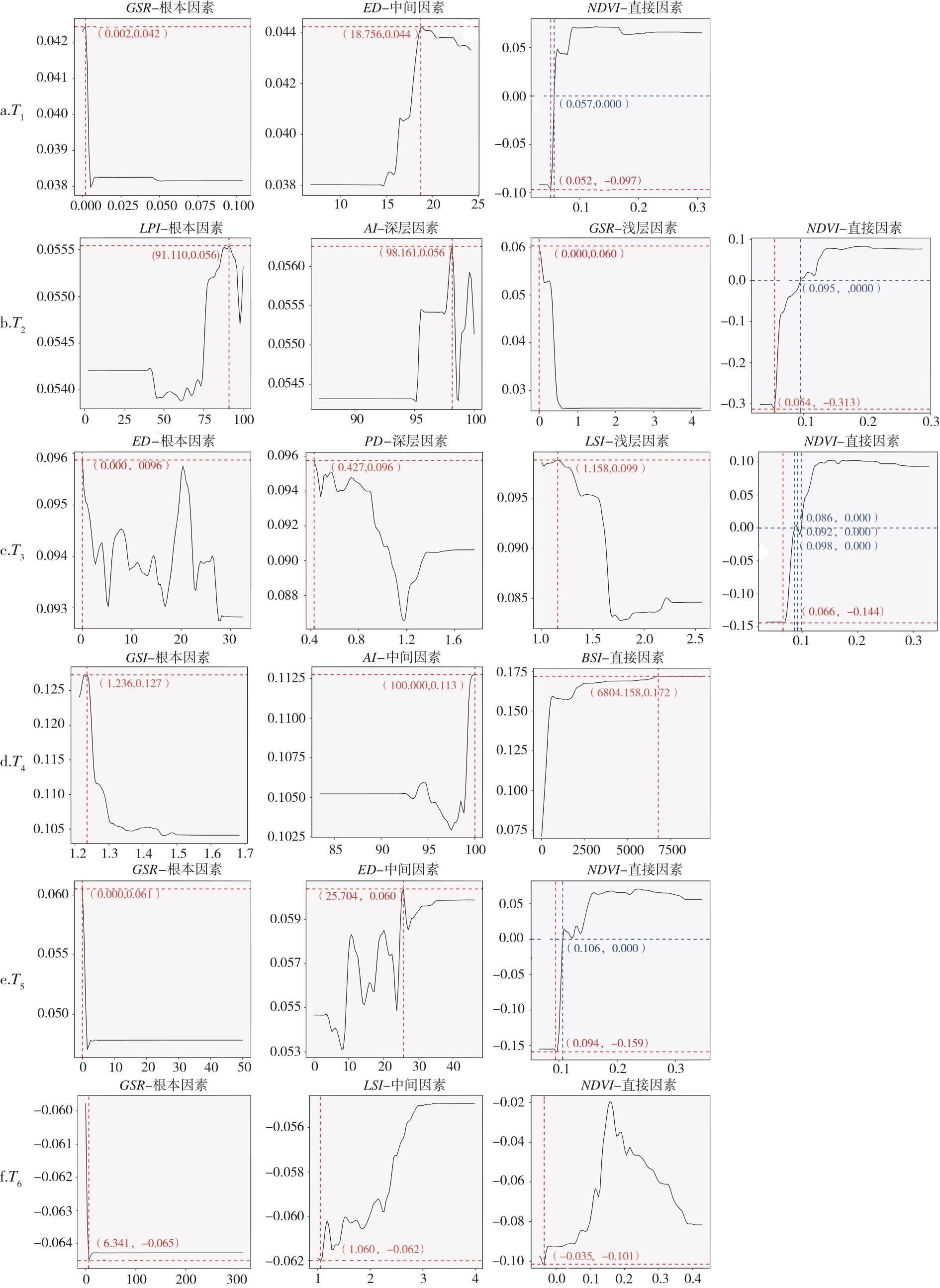
Focusing on Hefei's central urban area and based on the multi-source data such as Landsat data, NPP-VIIRS-like nighttime light data, land cover data, green space data, and building footprint data, this study systematically investigates the gradient differences and marginal effects of urban morphological indicators on heat island intensity using the DEMATEL-ISM model with GBRT (Gradient Boosted Regression Trees). Key findings reveal that: 1) Heat island intensity increased with urban expansion from 2006 to 2020, but decelerated over time. 2) Urban morphology indicators exhibit gradient-dependent impacts on urban heat island intensity. Critical optimization pathways vary across development gradients: land-use configuration dominates in high-development zones, while green space patterns are prioritized in low-development zones. 3) Marginal effects of morphological indicators show distinct gradient variations. The intensity and direction of key indicators' impacts shift with their values, accompanied by divergent thresholds and positive/negative critical points.

WANG Li , CHENG Yujia . Gradient Differences of Urban Development Regarding the Impact of Urban Spatial Form on the Intensity of the Urban Heat Island: A Case Study for Hefei City[J]. Economic geography, 2026 , 46(1) : 108 -118 . DOI: 10.15957/j.cnki.jjdl.2026.01.011
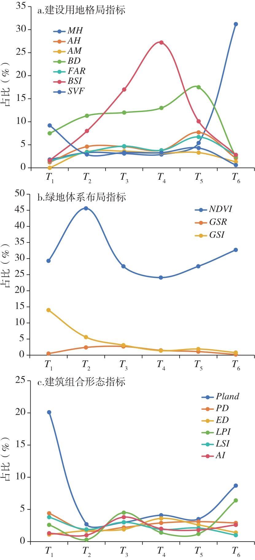
表1 城市形态指标及说明Tab.1 Indicator and explanation of urban morphology |
| 类别 | 指标 | 简写 | 意义 |
|---|---|---|---|
| 建设用地格局 | 斑块面积百分比 | Pland | 表征网格内的建设用地占比,量化建设用地在局域范围内的扩张程度 |
| 斑块密度 | PD | 网格内的斑块数量 | |
| 边缘密度 | ED | 网格内建设用地斑块的边缘总长度,反映景观破碎化程度 | |
| 最大斑块指数 | LPI | 建设用地斑块占网格的比例 | |
| 斑块形状指标 | LSI | 表征建设用地斑块形状的复杂程度,量化斑块形状的复杂性和不规则性 | |
| 聚合度 | AI | 建设用地斑块聚集与连接的程度 | |
| 绿地体系布局 | 植被归一化指数 | NDVI | 量化植被生长状态和覆盖度等植被信息 |
| 绿地率 | GSR | 表征在城市建成区内各类绿化用地的总面积占城市建成区总用地面积的比例 | |
| 绿地周长面积分维数 | GSI | 表征绿地斑块形状的复杂程度 | |
| 建筑组合形态 | 最高建筑高度 | MH | 网格内建筑的最大高度 |
| 平均建筑高度 | AH | 网格内建筑的平均高度 | |
| 建筑起伏度 | AM | 网格内建筑最高点与最低点的高差 | |
| 建筑密度 | BD | 网格内建筑物的基底面积总和占总用地面积的比例,表征建筑物的覆盖率 | |
| 容积率 | FAR | 网格内总建筑面积与用地面积的比例 | |
| 建筑结构指数 | BSI | 网格内建筑占地面积与建筑高度的比值,表征建筑物的建筑结构特征 | |
| 天空开阔度 | SVF | 网格内天空面积与地面面积比值 |
| [1] |
|
| [2] |
|
| [3] |
牛陆, 张正峰, 彭中, 等. 中国地表城市热岛驱动因素及其空间异质性[J]. 中国环境科学, 2022, 42(2):945-953.
|
| [4] |
宋鑫博, 黄鹤, 郭军, 等. 城市形态对夏季热环境影响研究——以天津中心城区为例[J]. 生态环境学报, 2021, 30(11):2165-2174.
|
| [5] |
|
| [6] |
|
| [7] |
|
| [8] |
|
| [9] |
梁洪武, 阿里木江·卡斯木, 赵禾苗, 等. 基于地理探测器的乌鲁木齐市主城区地表温度及其影响因素[J]. 兰州大学学报(自然科学版), 2022, 58(3):356-363,371.
|
| [10] |
邸俊楠. 合肥市热岛“源—汇”景观时空特征及驱动因素研究[D]. 淮南: 安徽理工大学, 2024.
|
| [11] |
Earth Resources Observation and Science Center. Landsat 8-9 Operational Land Imager/Thermal Infrared Sensor Level-2,Collection 2[DB/OL]. Reston: U.S. Geological Survey, 2020.
|
| [12] |
Earth Resources Observation and Science Center. Landsat 4-5 Thematic Mapper Level-2,Collection 2[DB/OL]. Reston: U.S. Geological Survey, 2020.
|
| [13] |
熊鹰, 章芳. 基于多源数据的长沙市人居热环境效应及其影响因素分析[J]. 地理学报, 2020, 75(11):2443-2458.
|
| [14] |
|
| [15] |
李军, 赵彤, 朱维, 等. 基于Landsat8的重庆主城区城市热岛效应研究[J]. 山地学报, 2018, 36(3):452-461.
|
| [16] |
王森, 曾穗平, 卢鋆镆, 等. 郑州城市形态对热岛强度影响的城市发展梯度差异[J]. 环境科学, 2024, 46(3):1924-1936.
|
| [17] |
|
| [18] |
申杰, 张维维, 韩继刚. 城市化梯度下上海公园土壤微生物群落分布特征及关键驱动因素[J]. 生态学杂志, 2025, 44(10):3169-3177.
|
| [19] |
孙洋洋, 沈泽琦, 黄乐妍, 等. 不同城市绿地类型碳源/汇的城乡梯度格局——以杭州市为例[J]. 生态学报, 2024, 44(3):930-943.
|
| [20] |
陈晋, 卓莉, 史培军, 等. 基于DMSP/OLS数据的中国城市化过程研究——反映区域城市化水平的灯光指数的构建[J]. 遥感学报, 2003, 7(3):168-175.
|
| [21] |
杨柳, 梁俊红, 丁凯焱, 等. 从夜间灯光数据中提取城市建成区的改进方法[J]. 地理空间信息, 2024, 22(1):24-28.
|
| [22] |
陈彦光, 周一星. 城市化Logistic过程的阶段划分及其空间解释——对Northam曲线的修正与发展[J]. 经济地理, 2005, 25(6):817-822.
|
| [23] |
高珮义. 中外城市化比较分析[J]. 天津社会科学, 1990, 4(1):68-74.
|
| [24] |
|
| [25] |
周振国, 孔洁. 基于DEMATEL-ISM的商业建筑节能减排影响因素分析[J]. 工程管理学报, 2024, 38(4):66-70.
|
| [26] |
孔造杰, 赵啸天, 李斌, 等. 考虑不同专家偏好的区间粗糙数DEMATEL决策方法[J]. 制造业自动化, 2019, 41(5):66-69.
|
| [27] |
解云舒, 祝连波. 基于DEMATEL-ISM的旅游城市防霾建设韧性评价关键指标识别研究[J]. 上海节能, 2024, 1(12):1906-1915.
|
| [28] |
|
| [29] |
陈为公, 张娜, 张友森, 等. 基于DEMATEL-ISM的城市灾害韧性影响因素研究[J]. 灾害学, 2021, 36(1):1-6,17.
|
/
| 〈 |
|
〉 |