
Urbanization Process and Its Ecological Environment Response Pattern on the Loess Plateau,China
Received date: 2019-12-13
Revised date: 2020-03-26
Online published: 2025-05-14
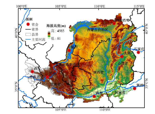
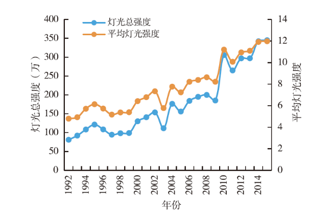
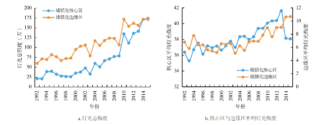
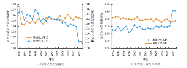
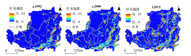
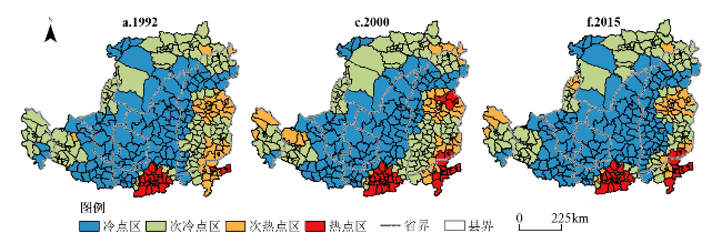
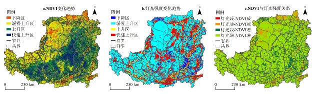
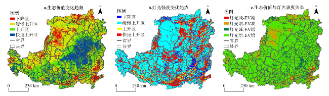
The scientific cognition of the urbanization process and its ecological environment response pattern of the Loess Plateau is an urgent need in building a sustainable urbanization and ecological environment protection pattern and implementing the ecological protection and high-quality development strategy of the Yellow River Basin. Based on the data of DMSP/OLS and NPP/VIIRS and the data of ecological environment factor from 1992 to 2015,the thesis studies the evolution process of urbanization spatial pattern and its ecological environment response pattern on the Loess Plateau through statistical analysis and GIS spatial analysis. The results show that: 1) From 1992 to 2015,the spatial expansion of urbanization on the Loess Plateau was significant. The density of social and economic activities in the core and peripheral areas of urbanization was gradually increasing,and the overall degree of intensification showed continuous increase. The county urbanization presents the spatial structure of "core-periphery" in geographical space;the urbanization hotspot and sub-hotspot areas are concentrated in the south and the east of the Loess Plateau. 2) The synchronous rise of regional light intensity,NDVI and ecological value is the dominant trend of urbanization and ecological environment evolution on the Loess Plateau. However, the NDVI and ecological value of urban agglomeration areas and energy development zones with significant rise in regional light intensity are declining,and the contradiction between urbanization and ecological environment is increasingly prominent. 3) The objective demand for a better ecological environment in the urbanization process on the Loess Plateau may promote the ecological environment construction in cities and towns and their vicinity,and form a new pattern of benign interaction between urbanization development and ecological environment protection.
SONG Yongyong , XUE Dongqian , MA Beibei , YANG Kaiyue , MI Wenbao . Urbanization Process and Its Ecological Environment Response Pattern on the Loess Plateau,China[J]. Economic geography, 2020 , 40(6) : 174 -184 . DOI: 10.15957/j.cnki.jjdl.2020.06.019
表1 2013年DMSP/OLS与NPP/VIIRS拟合结果和关键参数Tab.1 Fitting results and corresponding parameter values of DMSP/OLS and NPP/VIIRS in 2013 |
| 函数类型 | 模型表达 | R2 |
|---|---|---|
| 线性函数 | Y=2.0818X+3.192 | 0.3476 |
| 对数函数 | Y=8.277lnX+16.747 | 0.8459 |
| 多项式 | Y=(-8E-09)X6+(3E-06)X5-0.0004X4+ 0.0287X3-0.0684X2+11.372X+0.0486 | 0.6384 |
| [1] |
中国科学院可持续发展战略研究组. 2015中国可持续发展报告—重塑生态环境治理体系[M]. 北京: 科学出版社, 2015.
|
| [2] |
邱国玉, 张晓楠. 21世纪中国的城市化特点及其生态环境挑战[J]. 地球科学进展, 2019, 34(6):640-649.
|
| [3] |
|
| [4] |
未来地球计划过渡小组. 未来地球计划初步设计[M]. 曲建升,译. 北京: 科学出版社, 2015.
|
| [5] |
美国国家科学院国家研究理事会. 地球科学新的研究机遇[M]. 张志强,郑军卫,等译. 北京: 科学出版社, 2014.
|
| [6] |
樊杰, 王亚飞, 梁博. 中国区域发展格局演变过程与调控[J]. 地理学报, 2019, 74(12):2437-2 454.
|
| [7] |
陆大道, 陈明星. 关于“国家新型城镇化规划(2014—2020)”编制大背景的几点认识[J]. 地理学报, 2015, 70(2):179-185.
|
| [8] |
陈明星, 叶超, 陆大道, 等. 中国特色新型城镇化理论内涵的认知与建构[J]. 地理学报, 2019, 74(4):633-647.
|
| [9] |
|
| [10] |
方创琳, 崔学刚, 梁龙武. 城镇化与生态环境耦合圈理论及耦合器调控[J]. 地理学报, 2019, 74(12):2529-2 546.
|
| [11] |
|
| [12] |
|
| [13] |
|
| [14] |
|
| [15] |
|
| [16] |
|
| [17] |
郁鸿胜. 城市化研究国际理论前沿[M]. 上海: 上海社会科学出版社, 2017.
|
| [18] |
宋永永, 马蓓蓓, 李武斌, 等. 黄土高原县域城镇化的地域分异与动因机制[J]. 陕西师范大学学报:自然科学版, 2019, 47(4):9-21.
|
| [19] |
李双成, 赵志强, 王仰麟. 中国城市化过程及其资源与生态环境效应机制[J]. 地理科学进展, 2009, 28(1):63-71.
|
| [20] |
刘世梁, 朱家蓠, 许经纬, 等. 城市化对区域生态足迹的影响及其耦合关系[J]. 生态学报 2018, 38(24):8888-8 900.
|
| [21] |
孙黄平, 黄震方, 徐冬冬, 等. 泛长三角城市群城镇化与生态环境耦合的空间特征与驱动机制[J]. 经济地理, 2017, 37(2):163-170,186.
|
| [22] |
宋永永. 黄土高原城镇化过程及其生态环境响应[D]. 西安: 陕西师范大学, 2019.
|
| [23] |
周伟奇, 钱雨果, 等. 中国典型区域城市化过程及其生态环境效应[M]. 北京: 科学出版社, 2017.
|
| [24] |
方创琳, 鲍超, 黄金川, 等. 中国城镇化发展的地理学贡献与责任使命[J]. 地理科学, 2018, 38(3):321-331.
|
| [25] |
刘海猛, 方创琳, 李咏红. 城镇化与生态环境“耦合魔方”的基本概念及框架[J]. 地理学报, 2019, 74(8):1489-1 507.
|
| [26] |
方创琳. 中国新型城镇化高质量发展的规律性与重点方向[J]. 地理研究, 2019, 38(1):13-22.
|
| [27] |
施利锋, 张增祥, 刘芳, 等. 1973年—2013年经济特区城市空间扩展遥感监测[J]. 遥感学报, 2015, 19(6):1030-1 039.
|
| [28] |
杜军, 宁晓刚, 刘纪平, 等. 基于遥感监测的北京市城市空间扩展格局与形态特征分析[J]. 地域研究与开发, 2019, 38(2):73-78.
|
| [29] |
王莉红, 张军民. 基于地理探测器的绿洲城镇空间扩张驱动力分析——以新疆石河子市为例[J]. 地域研究与开发, 2019, 38(4):68-74.
|
| [30] |
World Development Report 2009:Reshaping Economic Geog-raphy[M]. Washing,D.C.: The World Bank, 2009.
|
| [31] |
樊杰. 地域功能—结构的空间组织途径—对国土空间规划实施主体功能区战略的讨论[J]. 地理研究 2019, 38(10):2373-2 387.
|
| [32] |
|
| [33] |
方创琳. 改革开放40年来中国城镇化与城市群取得的重要进展与展望[J]. 经济地理, 2018, 38(9):1-9.
|
| [34] |
中国科学院黄土高原综合科学考察队. 黄土高原综合治理开发分区研究[M]. 北京: 中国经济出版社,1990.
|
| [35] |
徐康宁, 陈丰龙, 刘修岩. 中国经济增长的真实性:基于全球夜间灯光数据的检验[J]. 经济研究, 2015(9):17-29.
|
| [36] |
梁丽, 边金虎, 李爱农, 等. 中巴经济走廊DMSP/OLS与NPP/VIIRS夜间灯光数据辐射一致性校正研究[J]. 遥感学报, 2020, 24(1):1993-2 002.
|
| [37] |
徐新良. 中国年度植被指数(NDVI)空间分布数据集[DB/OL]. 中国科学院资源环境科学数据中心数据注册与出版系统(http://www.resdc.cn/DOI),2018,DOI:10.12078/2018060601.
|
| [38] |
陈鹏飞. 北纬18°以北中国陆地生态系统逐月净初级生产力1公里栅格数据集(1985—2015)[J]. 全球变数数据学报, 2019, 3(1):35-42.
|
| [39] |
李武斌, 宋永永, 薛东前, 等. 1990—2015年黄土高原地区城镇化与城市发展数据集[DB/OL]. 西安:陕西师范大学, 2018, http://loess.geodata.cn/index.html.]
|
| [40] |
|
| [41] |
刘焱序, 吴文恒, 温晓金, 等. 晋陕蒙能源区城镇化过程及其对生态环境的影响[J]. 地理研究, 2013, 22(11):2009-2 020.
|
| [42] |
陈星星. 基于夜间灯光数据的武汉市城镇用地扩张识别与空间分布特征研究[J]. 西南师范大学学报:自然科学版, 2019, 44(1):70-78.
|
| [43] |
宋永永, 薛东前, 代兰海, 等. 陕北能源开发区县域社会剥夺的空间差异与形成机制[J]. 地理与地理信息科学, 2019, 35(1):109-117.
|
| [44] |
乔旭宁, 王林峰, 牛海鹏, 等. 基于NPP数据的河南省淮河流域生态经济协调性分析[J]. 经济地理, 2016, 36(7):173-189.
|
| [45] |
朱先进, 王秋凤, 郑涵, 等. 2001—2010年中国陆地生态系统农林产品利用的碳消耗的时空变异研究[J]. 第四纪研究, 2014, 34(4):762-768.
|
| [46] |
张同功, 赵得志. 我国煤炭价格波动影响因素实证研究[J]. 中国能源, 2018, 40(3):16-21.
|
/
| 〈 |
|
〉 |