
Spatial-Temporal Evolution of Land Transportation Accessibility and Economic Contact in Xiangxi Area in Recent 70 Years
Received date: 2019-10-23
Revised date: 2020-04-15
Online published: 2025-05-14
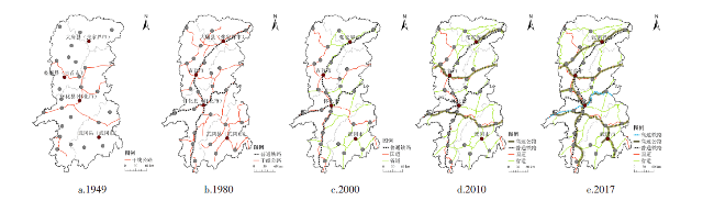
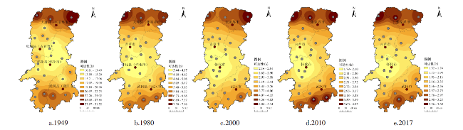
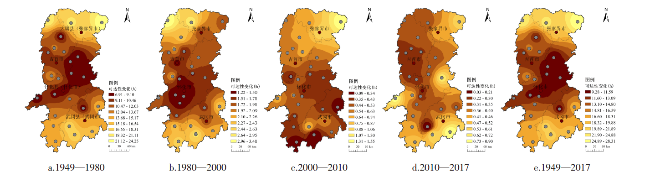
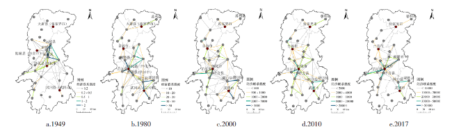
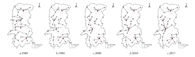
The development of land transportation is of great significance to the economic contact in Xiangxi area. By the accessibility measurement model and regional economic tie measurement model,the temporal and spatial evolution characteristics of land transportation accessibility and economic contact from 1949 to 2017 in Xiangxi area are quantitatively analyzed. It is found that: 1) The spatial pattern of regional land transportation accessibility has gradually evolved from the traffic corridor expansion to the irregular ring expansion and shows a "core-edge" pattern as a whole; 2) All cities have increased greatly of their external economic contact volume,and the imbalanced development trends among different regions are obvious; 3) Regional economic contact have been significantly strengthened,which has led to a multi-core economic pattern centered around Huaihua,Zhangjiajie and Wugang,combined structures are obvious,while their connections are not that close,and the regional economic integration is at a low level; 4) Regional priority economic contact represents a combined spatial structure,and the changes of regional priority economic contact core cities are influenced from water transportation to land transportation. In view of these,the construction of land transportation network system with reasonable layout and perfect structure should be speeded up; the construction of central cities and potential cities should be strengthened; the development planning of land and water transportation comprehensive system should be paid more attention,coastal cities should be revitalized through inland waterway transportation,and a rational and diversified regional economic contact pattern should be built.
JIAO Sheng , ZHANG Bingjie , HAN Zongwei . Spatial-Temporal Evolution of Land Transportation Accessibility and Economic Contact in Xiangxi Area in Recent 70 Years[J]. Economic geography, 2020 , 40(6) : 137 -146 . DOI: 10.15957/j.cnki.jjdl.2020.06.015
表1 道路速度赋值(km/h)Tab.1 Speed assignments on roads and railways (km/h) |
| 年份 | 公路 | 铁路 | 默认值 | |||
|---|---|---|---|---|---|---|
| 高速公路 | 国道 | 省道 | 高速铁路 | 普通铁路 | 非道路区域 | |
| 1949 | - | 30 | - | - | 5 | |
| 1980 | - | 40 | - | 50 | 10 | |
| 2000 | - | 80 | 60 | - | 60 | 20 |
| 2010 | 100 | 80 | 60 | - | 100 | 30 |
| 2017 | 100 | 80 | 60 | 300 | 120 | 30 |
表2 1949—2017年湘西地区陆路可达性平均值、极值(h)Tab.2 Average and extreme value of land transportation accessibility in Xiangxi area from 1949 to 2017 |
| 年份 | 平均值 | 最大值 | 最小值 |
|---|---|---|---|
| 1949 | 17.87 | 31.52 | 10.81 |
| 1980 | 5.17 | 7.98 | 3.44 |
| 2000 | 3.19 | 5.34 | 2.16 |
| 2010 | 2.66 | 4.02 | 1.79 |
| 2017 | 2.26 | 3.69 | 1.52 |
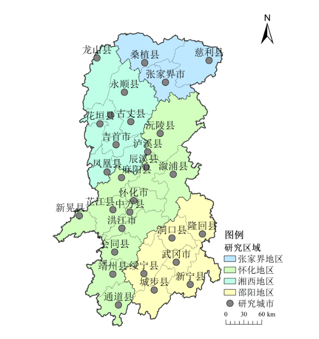
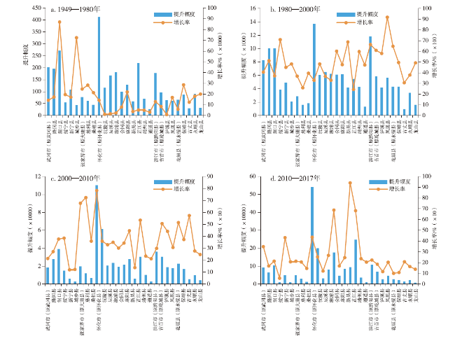
表3 1949—2017年湘西地区城市对外经济联系总量/104×104人·104元 h-2Tab.3 The external economic contact volume in Xiangxi area from 1949 to 2017 |
| 城市 | 1949 | 排序 | 1980 | 排序 | 2000 | 排序 | 2010 | 排序 | 2017 | 排序 |
|---|---|---|---|---|---|---|---|---|---|---|
| 武冈市(原武冈县) | 1.42 | 8 | 203.22 | 4 | 8 441.12 | 6 | 26 509.01 | 12 | 118 747.87 | 7 |
| 隆回县 | 1.13 | 12 | 195.93 | 5 | 10 222.50 | 5 | 37 998.05 | 5 | 101 959.55 | 12 |
| 洞口县 | 0.31 | 20 | 270.82 | 2 | 10 300.82 | 4 | 49 114.72 | 3 | 153 790.33 | 6 |
| 绥宁县 | 0.27 | 23 | 53.78 | 23 | 3 865.45 | 21 | 18 733.00 | 19 | 29 039.53 | 24 |
| 新宁县 | 0.63 | 16 | 108.20 | 11 | 4 972.16 | 15 | 10 919.97 | 23 | 58 033.70 | 17 |
| 城步县 | 0.06 | 28 | 42.31 | 25 | 2 081.07 | 24 | 4 639.09 | 28 | 14 254.35 | 27 |
| 张家界市(原大庸县) | 0.31 | 21 | 76.82 | 16 | 2 902.72 | 23 | 22 535.52 | 17 | 70 479.69 | 14 |
| 慈利县 | 0.22 | 25 | 61.49 | 20 | 1 651.91 | 26 | 13 614.37 | 21 | 41 583.43 | 22 |
| 桑植县 | 0.21 | 26 | 45.21 | 24 | 1 831.96 | 25 | 8 415.91 | 25 | 20 686.54 | 25 |
| 怀化市(原怀化县) | 2.89 | 6 | 415.01 | 1 | 14 054.66 | 2 | 124 061.50 | 1 | 664 365.95 | 1 |
| 中方县 | - | - | - | - | 17 105.59 | 1 | 78 618.69 | 2 | 277 219.29 | 3 |
| 沅陵县 | 9.84 | 2 | 124.89 | 10 | 6 141.08 | 11 | 26 361.05 | 13 | 58 241.38 | 16 |
| 辰溪县 | 10.41 | 1 | 178.12 | 7 | 6 687.50 | 7 | 30 083.46 | 9 | 110 324.60 | 9 |
| 溆浦县 | 7.71 | 3 | 187.94 | 6 | 6 368.13 | 8 | 25 579.24 | 14 | 201 413.40 | 4 |
| 会同县 | 1.27 | 11 | 101.32 | 12 | 6 193.60 | 10 | 27 448.45 | 10 | 73 740.62 | 13 |
| 麻阳县 | 0.59 | 17 | 128.96 | 9 | 6 254.64 | 9 | 34 177.47 | 8 | 118 310.93 | 8 |
| 新晃县 | 1.58 | 7 | 60.59 | 22 | 4 224.67 | 20 | 10 044.85 | 24 | 104 471.54 | 10 |
| 芷江县 | 4.27 | 5 | 224.16 | 3 | 5 693.04 | 13 | 36 149.35 | 7 | 282 593.07 | 2 |
| 靖州县 | 1.41 | 9 | 71.37 | 18 | 4 336.00 | 18 | 14 488.27 | 20 | 48 685.38 | 20 |
| 通道县 | 0.87 | 15 | 27.58 | 28 | 1 329.33 | 28 | 4 144.86 | 29 | 12 609.35 | 29 |
| 洪江市(原黔阳县) | 1.37 | 10 | 177.90 | 8 | 11 969.82 | 3 | 47 736.36 | 4 | 154 564.82 | 5 |
| 吉首市(原乾城县) | 1.12 | 14 | 96.34 | 13 | 5 963.45 | 12 | 36 168.79 | 6 | 103 007.22 | 11 |
| 泸溪县 | 7.61 | 4 | 71.93 | 17 | 4 242.15 | 19 | 22 966.90 | 16 | 49 554.95 | 19 |
| 凤凰县 | 0.36 | 19 | 61.10 | 21 | 5 672.06 | 14 | 23 062.23 | 15 | 69 853.83 | 15 |
| 花垣县(原永绥县) | 1.13 | 13 | 66.64 | 19 | 4 376.62 | 17 | 26 915.62 | 11 | 53 764.60 | 18 |
| 保靖县 | 0.30 | 22 | 86.99 | 15 | 4 396.16 | 16 | 20 790.01 | 18 | 43 242.72 | 21 |
| 古丈县 | 0.24 | 24 | 30.17 | 27 | 952.94 | 29 | 6 417.69 | 26 | 19 735.70 | 26 |
| 永顺县 | 0.50 | 18 | 89.69 | 14 | 3 482.94 | 22 | 13 129.13 | 22 | 34 482.29 | 23 |
| 龙山县 | 0.16 | 27 | 32.31 | 26 | 1 620.94 | 27 | 5 627.27 | 27 | 13 393.85 | 28 |
| [1] |
|
| [2] |
|
| [3] |
|
| [4] |
|
| [5] |
|
| [6] |
|
| [7] |
曹小曙, 薛德升, 阎小培. 中国干线公路网络联结的城市通达性[J]. 地理学报, 2005, 60(6):903-910.
|
| [8] |
金凤君, 王姣娥. 20世纪中国铁路网扩展及其空间通达性[J]. 地理学报, 2004, 59(2):293-302.
|
| [9] |
姜海宁, 谷人旭, 陆玉麒, 等. 江苏省民用机场可达性及其服务能力评价[J]. 地理科学, 2010, 16(4):521-528.
|
| [10] |
李国平, 王立明, 杨开忠. 深圳与珠江三角洲区域经济联系的测度及分析[J]. 经济地理, 2001, 21(1):33-37.
|
| [11] |
李亚婷, 潘少奇, 苗长虹. 中原经济区县际经济联系网络结构及其演化特征[J]. 地理研究, 2014, 33(7):1239-1 250.
|
| [12] |
刘海隆, 包安明, 陈曦, 等. 新疆交通可达性对区域经济的影响分析[J]. 地理学报, 2008, 63(4):428-436.
|
| [13] |
程钰, 刘雷, 任建兰, 等. 济南都市圈交通可达性与经济发展水平测度及空间格局研究[J]. 经济地理, 2013, 33(3):59-64.
|
| [14] |
徐维祥, 陈斌, 李一曼. 基于陆路交通的浙江省城市可达性及经济联系研究[J]. 经济地理, 2013, 33(12):49-53.
|
| [15] |
尹鹏, 李诚固, 陈才. 东北地区省际城市可达性及经济联系格局[J]. 经济地理, 2014, 34(6):68-74.
|
| [16] |
罗鹏飞, 徐逸伦, 张楠楠. 高速铁路对区域可达性的影响研究——以沪宁地区为例[J]. 经济地理, 2004, 24(3):407-411.
|
| [17] |
李小马, 刘常富. 基于网络分析的沈阳城市公园可达性和服务[J]. 生态学报, 2009, 29(3):1554-1 562.
|
| [18] |
陈少沛, 丘健妮, 庄大昌. 基于潜力模型的广东城市可达性度量及经济联系分析[J]. 地理与地理信息科学, 2014, 30(6):64-69.
|
| [19] |
苗长虹, 王海江. 河南省城市的经济联系方向与强度——兼论中原城市群的形成与对外联系[J]. 地理研究, 2006, 25(2):222-232.
|
| [20] |
吴威, 曹有挥, 曹卫东, 等. 开放条件下长江三角洲区域的综合交通可达性空间格局[J]. 地理研究, 2007(2):391-402.
|
| [21] |
湖南省志编纂委员会. 湖南省志(第十卷)-交通志. 公路篇[M]. 长沙: 湖南人民出版社,1982
|
| [22] |
陈娱, 金凤君, 陆玉麒, 等. 京津冀地区陆路交通网络发展过程及可达性演变特征[J]. 地理学报, 2017, 72(12):2252-2 264.
|
| [23] |
李平华, 陆玉麒. 可达性研究的回顾与展望[J]. 地理科学进展, 2005, 24(3):69-78.
|
| [24] |
吴威, 曹有挥, 曹卫东, 等. 长江三角洲公路网络的可达性空间格局及其演化[J]. 地理学报, 2006, 61(10):1065-1 074.
|
| [25] |
王欣, 吴殿廷, 王红强. 城市间经济联系的定量计算[J]. 城市发展研究, 2006, 13(3):55-59.
|
| [26] |
孟德友, 陆玉麒. 基于引力模型的江苏区域经济联系强度与方向[J]. 地理科学进展, 2009, 28(5):697-704.
|
| [27] |
孟德友, 陆玉麒. 基于铁路客运网络的省际可达性及经济联系格局[J]. 地理研究, 2012, 31(1):107-122.
|
| [28] |
周一星. 主要经济联系方向论[J]. 城市规划, 1998(2):22-25.
|
| [29] |
顾朝林, 庞海峰. 基于重力模型的中国城市体系空间联系与层域划分[J]. 地理研究, 2008, 27(1):1-12.
|
| [30] |
张衢. 湘西沅水流域城市起源与发展研究[D]. 长沙: 湖南师范大学, 2003.
|
/
| 〈 |
|
〉 |