
Spatial Heterogeneity of Urban Expansion Structure Based on Spatial Clustering Method in Dongguan City
Received date: 2018-10-17
Revised date: 2019-01-24
Online published: 2025-04-29
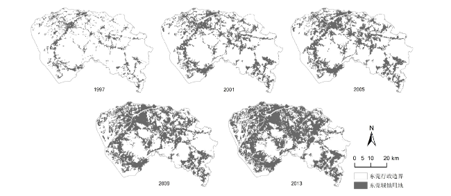
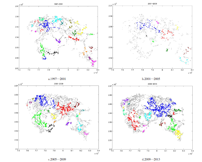
Using ENVI to interpret the TM/ETM remote sensing image of Dongguan City from 1997 to 2013 and applying the landscape gradient analysis, the combination of the landscape expansion index(LEI) and the spatial hierarchical clustering algorithm of AMOEBA, this article detected spatiotemporal heterogeneity characteristics of clusters, the extent of urban expansion change and urban expansion type in the urban landscape and explored the variation characteristics of space structure in the process of urban sprawl. The results showed that the proposed method could identify and visualize different urban expansion clusters. During the period of 1997 to 2013, urban expansion in Dongguan showed a state of marginal expansion. Within a range of 10 km from the city center, a relatively mature urban area had been formed, and within a range of 10-40 km it was belonged to the active area of expansion. Affected by the relative distance from the city center and surrounding cities, and the extension of major traffic lines, the spatial configuration of newly added urban land formed several clusters with spatiotemporal heterogeneity characteristics. This study can be used to help relevant departments to guide targeted control measures for urbanization development.
WAN Yiliang , JIN Rui , TANG Jianbo , JIN Meihan . Spatial Heterogeneity of Urban Expansion Structure Based on Spatial Clustering Method in Dongguan City[J]. Economic geography, 2019 , 39(3) : 84 -92 . DOI: 10.15957/j.cnki.jjdl.2019.03.010
表1 Landsat TM/ETM+影像数据Tab.1 Landsat TM/ETM+ remote sensing image |
| 年份 | 影像 | 轨道号 | 日期 | 空间分辨率 |
|---|---|---|---|---|
| 1997 | Landsat 4-5 TM | 121/44 | 1996-03-03 | 30 m |
| 2001 | Landsat 4-5 TM | 122/44 | 2001-12-30 | 30 m |
| 2005 | Landsat 4-5 TM | 121/44 | 2005-07-18 | 30 m |
| 2009 | Landsat 4-5 TM | 121/44 | 2009-11-02 | 30 m |
| 2013 | Landsat 8 OLI_TIRS | 122/44 | 2013-12-31 | 30 m |
表2 遥感图像解译总体准确率及Kappa系数Tab.2 The overall accuracy and Kappa coefficient of remote sensing image interpretation from 1997 to 2013 |
| 1997 | 2001 | 2005 | 2009 | 2013 | |
|---|---|---|---|---|---|
| 总体准确率(%) | 86.6 | 90.2 | 89.3 | 87.5 | 91.3 |
| Kappa系数 | 0.83 | 0.87 | 0.86 | 0.84 | 0.88 |
表3 拟采用的景观格局指数[24]Tab.3 Landscape metrics |
| 景观格局指数 | 说明(单位) | 公式 |
|---|---|---|
| 斑块类型面积(CA) | 某斑块类型中所有斑块面积总和(hm2) | |
| 斑块数量(NP) | 某斑块类型中所有斑块数量总和(无) | |
| 斑块密度(PD) | 单位面积上的斑块数量(块/100 hm2) | |
| 景观形状(LSI) | 某一景观类型所有斑块边的总长度与景观最小总长度的比值(无) | |
| 聚合指数(AI) | 所有类型的包括相关斑块类型在内的相似邻接的数量与最大可能的包括相关斑块类型在内的相似邻接的数量的比值(%) | |
| 蔓延度(CONTAG) | 描述景观里不同斑块类型的团聚程度或延展趋势(%) |
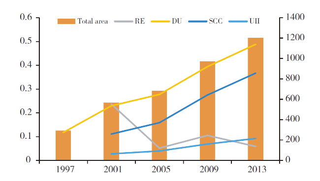
表4 东莞1997—2013年整体景观格局特征Tab.4 Overall landscape characteristics of Dongguan from 1997 to 2013 |
| 年份 | 景观格局指数 | ||||
|---|---|---|---|---|---|
| NP | PD | LSI | CONTAG | AI | |
| 1997 | 703 | 0.1736 | 45.21 | 77.4222 | 92.2077 |
| 2001 | 405 | 0.1000 | 35.95 | 66.2501 | 95.5861 |
| 2005 | 390 | 0.0963 | 35.46 | 62.2976 | 96.0415 |
| 2009 | 936 | 0.2311 | 40.66 | 53.7359 | 96.1794 |
| 2013 | 926 | 0.2286 | 39.88 | 49.0557 | 96.6319 |
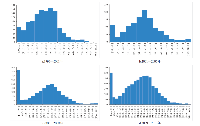
表5 不同时间段LEI各个区间值数目所占百分比Tab.5 Proportion of LEI value in different level from 1997 to 2013 |
| LEI区间 | 1997—2001 | 2001—2005 | 2005—2009 | 2009—2013 |
|---|---|---|---|---|
| 0.034557 | 0.057937 | 0.133453 | 0.061438 | |
| 0.768819 | 0.663492 | 0.621917 | 0.665485 | |
| 0.196625 | 0.278571 | 0.24463 | 0.273076 |
| [1] |
|
| [2] |
|
| [3] |
洪世键, 曾瑜琦. 制度变迁背景下中国城市空间增长驱动力探讨[J]. 经济地理, 2016, 36(6):67-73.
|
| [4] |
吴一凡, 刘彦随, 李裕瑞. 中国人口与土地城镇化时空耦合特征及驱动机制[J]. 地理学报, 2018, 73(10):1865-1 879.
|
| [5] |
张占录. 北京市城市用地扩张驱动力分析[J]. 经济地理, 2009, 29(7):1182-1 185.
|
| [6] |
李恩康, 陆梦秋, 陆玉麒, 等. 区域的适度空间规模及边际扩张效应——以江苏省为例[J]. 经济地理, 2018, 38(10):46-53.
|
| [7] |
刘昭华, 张春艳. 开封市城市扩张动态监测及驱动因子分析[J]. 国土资源遥感, 2018, 30(4):193-199.
|
| [8] |
毛蒋兴, 闫小培. 国外城市交通系统与土地利用互动关系研究[J]. 城市规划, 2004,28:64-69.
|
| [9] |
|
| [10] |
|
| [11] |
王兴中. 后工业化大城市内部经济空间结构和演化主导本质[J]. 人文地理, 1989(2):1-6.
|
| [12] |
|
| [13] |
|
| [14] |
饶会林. 试论城市空间结构的经济意义[J]. 中国社会科学, 1985(2):49-58.
|
| [15] |
艾定增. 古代城市模式对现代城市规划的影响——城市空间结构的跨文化研究[J]. 城市规划, 1987(3):44-48.
|
| [16] |
陆大道. 我国的城镇化进程与空间扩张[J]. 城市规划学刊, 2007(4):14-17.
|
| [17] |
郑伯红, 王桂芹. 基于产业用地扩展的湘潭城市空间演变及优化[J]. 经济地理, 2017, 37(6):92-99.
|
| [18] |
|
| [19] |
|
| [20] |
王磊, 李成丽. 我国中部地区城市群多中心结构的增长效应[J]. 长江流域资源与环境, 2018, 27(10):2231-2 240.
|
| [21] |
|
| [22] |
|
| [22] |
郭泺, 杜世宏, 孙皓铭, 等. 珠海市城区景观空间格局特征分析[J]. 地球信息科学学报, 2013, 15(2):307-313.
|
| [23] |
|
| [24] |
张荣天, 张小林, 李传武. 镇江市土地利用景观格局分析[J]. 经济地理, 2012, 32(9):132-137.
|
| [25] |
|
| [26] |
孟楠, 韩宝龙, 王海洋, 等. 澳门城市生态系统格局变化研究[J]. 生态学报, 2018, 38(18):6442-6 451.
|
| [27] |
东莞市统计局, 国家统计局东莞调查队. 东莞统计年鉴—2017[M]. 北京: 中国统计出版社, 2017.
|
| [28] |
|
| [29] |
傅伯杰, 陈利顶, 马克明, 等. 景观生态学的原理及应用[M]. 北京: 科学出版社,2002:42-57.
|
| [30] |
刘小平, 黎夏, 陈逸敏, 等. 景观扩张指数及其在城市扩展分析中的应用[J]. 地理学报, 2009, 64(12):1430-1 438.
|
| [31] |
|
| [32] |
|
/
| 〈 |
|
〉 |
