
Spatio-Temporal Trajectories of Urban Land Use Change During 1980-2015 and Future Scenario Simulation in Beijing-Tianjin-Hebei Urban Agglomeration
Received date: 2018-10-10
Revised date: 2018-12-03
Online published: 2025-04-29
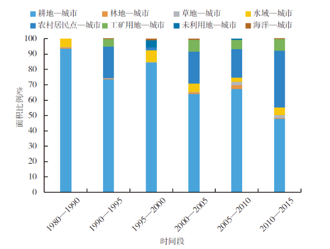
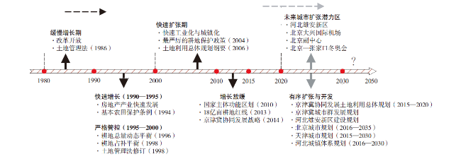
Monitoring urban land use change and simulating future scenarios are important to accurately obtain the characteristic of urban expansion, optimize the development pattern of urban land, and promote the coordinated development of the region. Based on multi-stage remote sensing images and land use data, this study analyzed the spatio-temporal trajectories and driving forces of the urban land use in Beijing-Tianjin-Hebei urban agglomeration from 1980 to 2015, further simulated the spatial pattern of urban land use under different development scenarios from 2015 to 2050. The results showed that the area of urban land in Beijing-Tianjin-Hebei urban agglomeration increased by 5574.80 km2 in the past 35 years. The urban land expansion speed was characterized by "high speed-low speed-high speed-low speed". About 66.61% of the new developed urban land occupied cultivated land, and the gravity center of urban land had a trend to move towards the northwest. The growth of GDP (Gross Domestic Product) and urban population were the main driving factors of urban expansion, while a series of policies also had some effects on urban expansion. Until 2050, the area of urban land will increase by 4 122.14 km2, 2 756.12 km2 and 3 439.14 km2 under the base scenario, cropland protection scenario and ecological protection scenario in Beijing-Tianjin-Hebei urban agglomeration, respectively. The suburbs of Beijing and Hebei province will be the potential area and new growth pole of urban expansion. Therefore, it is necessary to strengthen the control of geographical space and the layout optimization of urban ecological space in order to ensure the orderly development of urban land and the ecological security of urban agglomeration.
LI Xiaoyong , KUANG Wenhui . Spatio-Temporal Trajectories of Urban Land Use Change During 1980-2015 and Future Scenario Simulation in Beijing-Tianjin-Hebei Urban Agglomeration[J]. Economic geography, 2019 , 39(3) : 187 -194 . DOI: 10.15957/j.cnki.jjdl.2019.03.022
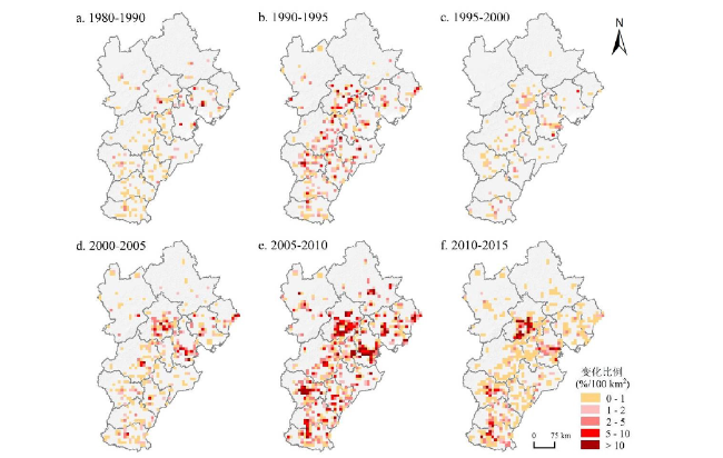
表1 1980—2015年京津冀城市群城市用地扩张Tab.1 Urban expansion in Beijing-Tianjin-Hebei urban agglomeration from 1980 to 2015 |
| 时间段 | 变化面积 (km2) | 年变化面积 (km2/a) | 年变化率 (%/a) | 动态度 (%/a) |
|---|---|---|---|---|
| 1980—1990 | 187.16 | 18.72 | 0.88 | 0.02 |
| 1990—1995 | 1 283.61 | 256.72 | 7.54 | 0.12 |
| 1995—2000 | 133.29 | 26.66 | 0.75 | 0.01 |
| 2000—2005 | 1 002.93 | 200.59 | 4.42 | 0.10 |
| 2005—2010 | 2 121.18 | 424.24 | 6.37 | 0.21 |
| 2010—2015 | 846.63 | 169.33 | 2.25 | 0.08 |
| 1980—2015 | 5 574.80 | 159.28 | 8.23 | 0.08 |
表2 城市用地变化与社会经济因素的相关分析Tab.2 Correlations analysis between urban land and social economic determines |
| 指标/时段 | 1980—1990 | 1990—1995 | 1995—2000 | 2000—2005 | 2005—2010 | 2010—2015 | 1980—2015 |
|---|---|---|---|---|---|---|---|
| GDP | 0.29 | 0.84** | 0.64 | 0.90** | 0.88** | 0.88** | 0.61** |
| TPOP | -0.01 | 0.94** | 0.64 | 0.79* | 0.85* | 0.80* | 0.69** |
| UPOP | 0.15 | 0.97** | 0.68 | 0.65 | 0.89** | 0.75* | 0.70** |
| IP | / | 0.51 | 0.61 | 0.94** | 0.81* | 0.46 | 0.56** |
| IFA | / | 0.83* | 0.87** | 0.83* | 0.75 | 0.48 | 0.45** |
| PI | 0.52 | -0.05 | 0.20 | 0.19 | -0.16 | -0.31 | 0.24 |
| SI | 0.28 | 0.23 | 0.77* | 0.90** | 0.70 | 0.52 | 0.54* |
| TI | 0.22 | 0.90** | 0.57 | 0.81* | 0.84* | 0.93** | 0.58* |
| LFR | / | 0.86** | 0.54 | 0.82* | 0.78 | 0.66 | 0.49** |
注:“/”表示无数据,“*”表示p<0.05,“**”表示p<0.01。 |
表3 2015—2050年京津冀城市群城市化情景预测Tab.3 Urbanization foresting of Beijing-Tianjin-Hebei urban agglomeration area from 2015 to 2050 |
| 发展情景 | 2015—2020 | 2020—2030 | 2030—2050 | ||
|---|---|---|---|---|---|
| 基准情景 | 扩张面积(km2) | 761.42 | 1 296.70 | 2 064.02 | |
| 扩张速度(km2/a) | 152.28 | 129.67 | 103.20 | ||
| 耕地保护 情景 | 扩张面积(km2) | 538.46 | 785.27 | 1 432.39 | |
| 扩张速度(km2/a) | 107.69 | 78.53 | 71.62 | ||
| 生态保护 情景 | 扩张面积(km2) | 649.94 | 1 040.99 | 1 748.21 | |
| 扩张速度(km2/a) | 129.99 | 104.10 | 87.41 | ||
| [1] |
|
| [2] |
|
| [3] |
|
| [4] |
|
| [5] |
|
| [6] |
|
| [7] |
黄金川, 林浩曦. 京津冀城市群多情景空间演化模拟[J]. 地理研究, 2017, 36(3):506-517.
|
| [8] |
姚士谋, 王辰, 张落成, 等. 我国资源环境对城镇化问题的影响因素[J]. 地理科学进展, 2008, 27(3):94-100.
|
| [9] |
匡文慧, 刘纪远, 邵全琴, 等. 区域尺度城市增长时空动态模型及其应用[J]. 地理学报, 2011, 66(2):178-188.
|
| [10] |
|
| [11] |
刘翠玲, 龙瀛. 京津冀地区城镇空间扩张模拟与分析[J]. 地理科学进展, 2015, 34(2):217-228.
|
| [12] |
王翠平, 王豪伟, 李春明, 等. 基于DMSP/OLS影像的我国主要城市群空间扩张特征分析[J]. 生态学报, 2012, 32(3):942-954.
|
| [13] |
曾馨漫, 刘慧, 刘卫东. 京津冀城市群城市用地扩张的空间特征及俱乐部收敛分析[J]. 自然资源学报, 2015, 30(12):2045-2 056.
|
| [14] |
曹诗颂, 胡德勇, 赵文吉, 等. 不透水地表盖度视角下中美城市群空间结构对比——以“京津冀”与“波士华”为例[J]. 地理学报, 2017, 72(6):1017-1 031.
|
| [15] |
匡文慧, 杨天荣, 颜凤芹. 河北雄安新区建设的区域地表本底特征与生态管控[J]. 地理学报, 2017, 72(6):947-959.
|
| [16] |
|
| [17] |
|
| [18] |
王利伟, 冯长春. 转型期京津冀城市群空间扩展格局及其动力机制——基于夜间灯光数据方法[J]. 地理学报, 2016, 71(12):2155-2 169.
|
| [19] |
李进涛, 刘彦随, 杨园园, 等. 1985—2015年京津冀地区城市用地时空演变特征及驱动因素研究[J]. 地理研究, 2018, 37(1):37-52.
|
| [20] |
|
| [21] |
文雅, 龚建周, 胡银根, 等. 基于生态安全导向的城市空间扩展模拟与分析[J]. 地理研究, 2017, 36(3):518-528.
|
| [22] |
|
| [23] |
|
| [24] |
刘纪远, 张增祥, 庄大方, 等. 20世纪90年代中国土地利用变化时空特征及其成因分析[J]. 地理研究, 2003, 22(1):1-12.
|
| [25] |
|
| [26] |
刘纪远, 匡文慧, 张增祥, 等. 20世纪80年代末以来中国土地利用变化的基本特征与空间格局[J]. 地理学报, 2014, 69(1):3-14.
|
| [27] |
刘纪远, 宁佳, 匡文慧, 等. 2010—2015年中国土地利用变化的时空格局与新特征[J]. 地理学报, 2018, 73(5):789-802.
|
| [28] |
|
| [29] |
冀咏赞, 闫慧敏, 刘纪远, 等. 基于MODIS数据的中国耕地高中低产田空间分布格局[J]. 地理学报, 2015, 70(5):766-778.
|
| [30] |
牛忠恩, 闫慧敏, 陈静清, 等. 基于VPM与MOD 17产品的中国农田生态系统总初级生产力估算比较[J]. 农业工程学报, 2016, 32(4):191-198.
|
| [31] |
王佳月, 辛良杰. 基于Globe Land 30数据的中国耕地与粮食生产的时空变化分析[J]. 农业工程学报, 2017, 33(22):1-8.
|
| [32] |
刘彦随, 王介勇, 郭丽英. 中国粮食生产与耕地变化的时空动态[J]. 中国农业科学, 2009, 42(12):4269-4 274.
|
| [33] |
王开泳, 丁俊, 王甫园. 全面二孩政策对中国人口结构及区域人口空间格局的影响[J]. 地理科学进展, 2016, 35(11):1305-1 316.
|
| [34] |
王开泳, 陈妤凡, 丁俊. 全面放开二孩政策下中国人口增长对城乡建设用地的影响与需求预测[J]. 中国土地科学, 2016, 30(9):37-47.
|
| [35] |
|
| [36] |
徐颖, 吕斌. 基于GIS与ANN的土地转化模型在城市空间扩展研究中的应用——以北京市为例[J]. 北京大学学报(自然科学版), 2008, 44(2):262-270.
|
| [37] |
徐新良, 闵稀碧, 田展. 基于GIS与LTM模型的上海市城市扩展模拟与预测[J]. 中国人口·资源与环境, 2010, 20(S2):136-139.
|
| [38] |
|
| [39] |
樊杰. 中国主体功能区划方案[J]. 地理学报, 2015, 70(2):186-201.
|
| [40] |
顾朝林, 管卫华, 刘合林. 中国城镇化2050:SD模型与过程模拟[J]. 中国科学:地球科学, 2017, 47(7):818-832.
|
| [41] |
王海军, 张彬, 刘耀林, 等. 基于重心-GTWR模型的京津冀城市群城镇扩展格局与驱动力多维解析[J]. 地理学报, 2018, 73(6):1076-1 092.
|
| [42] |
|
/
| 〈 |
|
〉 |
