
Evaluation and Pattern Optimization of Rural Production Space System Function:A Case Study of Banan District,Chongqing Municipality
Received date: 2018-09-29
Revised date: 2018-12-11
Online published: 2025-04-29
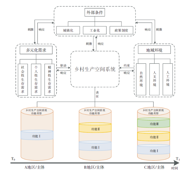
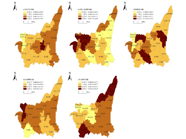
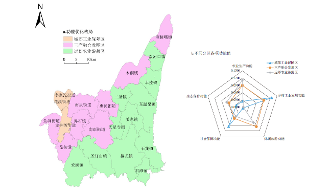
On the basis of analyzing the connotation of rural production space system function, this study establishes evaluation index system and evaluation model of rural production space system function from five specific functions including agricultural production function, rural industrial development function, leisure tourism function, social security function and ecological conservation function. Taking Banan District of Chongqing Municipality as research area and setting the towns and streets of Banan District to be research units, this study deeply analyzes the spatial distribution characteristics of the rural production space system function in 2017 and puts forward the spatial pattern optimization scheme of rural production space system function. The results show as follows: the spatial distribution of agricultural production function shows a characteristic of "high in the east, low in the west and partly prominent", while the rural industrial development function shows a trend of "high in the west, low in the east". The leisure tourism function shows a spatial distribution characteristic of "high in the east, low in the west and high values interspersed", while it is higher in the central part than the north and south on the social security function and presents a trend of "high in the east and low in the west" on the ecological conservation function. This study puts forward a optimization scheme of spatial pattern of rural production space system function divided into three different parts, that is the suburban industrial security area dominated by rural industrial development function and social security function, the tertiary industries integration development area dominated by agricultural production function, rural industrial development function and leisure tourism function, and the suburban agricultural recreation area dominated by agricultural production function and leisure tourism function. Therefore, this study provides theoretical guidance for the spatial distribution planning of the industrial prosperity which is one of the general requirements of Rural Revitalization Strategy.
HE Yanzhou , WANG Cheng . Evaluation and Pattern Optimization of Rural Production Space System Function:A Case Study of Banan District,Chongqing Municipality[J]. Economic geography, 2019 , 39(3) : 162 -171 . DOI: 10.15957/j.cnki.jjdl.2019.03.019
表1 乡村生产空间系统功能评价指标体系Tab.1 The evaluation index system of rural production space system function |
| 功能 | 指标 | 内涵 | 单位 | 性质 | 权重 |
|---|---|---|---|---|---|
| 农业生产功能 | 人均粮食产量 | 粮食总产量/乡村总人口 | t/人 | + | 0.0344 |
| 人均蔬菜产量 | 蔬菜总产量/乡村总人口 | t/人 | + | 0.0380 | |
| 人均水果产量 | 水果总产量/乡村总人口 | t/人 | + | 0.0278 | |
| 人均林牧渔产值 | (林业总产值+牧业总产值+渔业总产值)/乡村总人口 | 元/人 | + | 0.0256 | |
| 人均耕地面积 | 耕地面积/乡村总人口 | hm2/人 | + | 0.0266 | |
| 乡村工业发展功能 | 乡镇企业个数 | 反映乡镇企业的数量状况 | 个 | + | 0.1038 |
| 乡镇企业产值 | 反映乡镇企业的经济贡献能力 | 万元 | + | 0.1513 | |
| 乡镇企业从业人员数 | 反映乡镇企业的就业保障能力 | 人 | + | 0.1375 | |
| 休闲旅游功能 | 农家乐个数 | 指以农业和乡村消费为特点的旅游、娱乐、休闲度假的场所数量 | 个 | + | 0.0624 |
| 观光园个数 | 指从事休闲、观光、垂钓等功能的经营单位数量 | 个 | + | 0.0848 | |
| 年接待人次 | 指乡村休闲旅游一年接待游客的数量 | 人次 | + | 0.0749 | |
| 年营业收入 | 指乡村休闲旅游一年的营业收入 | 万元 | + | 0.0270 | |
| 社会保障功能 | 乡村地域内从业人员占比 | 乡村地域内从业人员/乡村总人口 | % | + | 0.0262 |
| 农村居民人均可支配收入 | 反映农村居民的平均收入水平 | 元/人 | + | 0.0390 | |
| 城乡居民收入平衡指数 | 农村居民人均可支配收入/城镇居民人均可支配收入 | — | + | 0.0279 | |
| 人均粮食保证率 | 粮食总产量/(乡村总人口·400 kg/人) | % | + | 0.0244 | |
| 生态保育功能 | 区域生态服务价值总量 | 区域生态服务价值总和(通过Costanza、谢高地等[32-33]的方法计算) | 元 | + | 0.0292 |
| 地均生态服务价值量 | 区域生态服务价值总和/研究单元面积 | 元/hm2 | + | 0.0133 | |
| 地质灾害警源指数 | 地灾点个数/研究区地灾点总数 | % | - | 0.0139 | |
| 水土流失率 | 水土流失面积/研究单元面积 | % | - | 0.0192 | |
| 地均化肥超标量 | 化肥施用量/研究单元耕地面积—单位耕地面积化肥施用安全标准上限* | kg/hm2 | - | 0.0065 | |
| 地均农药使用量 | 农药使用量/研究单元耕地面积 | kg/hm2 | - | 0.0063 |
注:*单位耕地面积化肥施用安全标准采用国际化肥施用安全标准上限225 kg/hm2。 |
| [1] |
谭雪兰, 于思远, 陈婉铃, 等. 长株潭地区乡村功能评价及地域分异特征研究[J]. 地理科学, 2017, 37(8):1203-1 210.
|
| [2] |
王成, 李颢颖. 乡村生产空间系统的概念性认知及其研究框架[J]. 地理科学进展, 2017, 36(8):913-923.
|
| [3] |
王成, 马小苏, 唐宁, 等. 农户行为视角下的乡村生产空间系统运行机制及重构启示. 地理科学进展, 2018, 37(5):636-646.
|
| [4] |
何焱洲, 王成, 唐宁, 等. 熵视角下的重庆市乡村生产空间系统状态量化研究[J]. 西南大学学报(自然科学版), 2018, 40(10):112-119.
|
| [5] |
|
| [6] |
|
| [7] |
|
| [8] |
|
| [9] |
|
| [10] |
|
| [11] |
|
| [12] |
|
| [13] |
|
| [14] |
|
| [15] |
刘玉, 冯健. 城乡结合部农业地域功能实现程度及变化趋势——以北京为例[J]. 地理研究, 2017, 36(4):673-683.
|
| [16] |
刘玉, 刘彦随, 郭丽英. 乡村地域多功能的内涵及其政策启示[J]. 人文地理, 2011(6):103-106,132.
|
| [17] |
刘彦随, 刘玉, 陈玉福. 中国地域多功能性评价及其决策机制[J]. 地理学报, 2011, 66(10):1379-1 389.
|
| [18] |
唐林楠, 刘玉, 潘瑜春, 等. 基于BP模型和Ward法的北京市平谷区乡村地域功能评价与分区[J]. 地理科学, 2016, 36(10):1514-1 521.
|
| [19] |
李平星, 陈雯, 孙伟. 经济发达地区乡村地域多功能空间分异及影响因素——以江苏省为例[J]. 地理学报, 2014, 69(6):797-807.
|
| [20] |
洪惠坤, 廖和平, 李涛, 等. 基于熵值法和Dagum基尼系数分解的乡村空间功能时空演变分析[J]. 农业工程学报, 2016, 32(10):240-248.
|
| [21] |
王成, 彭清, 唐宁, 等. 2005—2015年耕地多功能时空演变及其协同与权衡研究——以重庆市沙坪坝区为例[J]. 地理科学, 2018, 38(4):590-599.
|
| [22] |
王成, 唐宁. 重庆市乡村三生空间功能耦合协调的时空特征与格局演化[J]. 地理研究, 2018, 37(6):1100-1 114.
|
| [23] |
安悦, 周国华, 贺艳华, 等. 基于“三生”视角的乡村功能分区及调控——以长株潭地区为例[J]. 地理研究, 2018, 37(4):695-703.
|
| [24] |
梁发超, 刘诗苑, 刘黎明. 基于用地竞争力的闽南地区乡村景观功能冲突的识别[J]. 农业工程学报, 2017, 33(9):260-267.
|
| [25] |
刘光荣. 我国低碳乡村旅游问题及功能探析[J]. 中国农业资源与区划, 2016, 37(10):161-165,173.
|
| [26] |
陈影, 许皞, 陈亚恒, 等. 基于遥感影像的县域土地功能分类及功能转换分析[J]. 农业工程学报, 2016, 13(32):263-272.
|
| [27] |
杜国明, 孙晓兵, 王介勇. 东北地区土地利用多功能性演化的时空格局[J]. 地理科学进展, 2016, 35(2):232-244.
|
| [28] |
张英男, 龙花楼, 戈大专, 等. 黄淮海平原耕地功能演变的时空特征及其驱动机制[J]. 地理学报, 2018, 73(3):518-534.
|
| [29] |
夏征农, 陈至立, 巢峰, 等. 辞海[M]. 上海: 上海辞书出版社, 2009.
|
| [30] |
|
| [31] |
|
| [32] |
|
| [33] |
谢高地, 张彩霞, 张雷明, 等. 基于单位面积价值当量因子的生态系统服务价值化方法改进[J]. 自然资源学报, 2015, 30(8):1243-1 254.
|
| [34] |
王富喜, 毛爱华, 李赫龙, 等. 基于熵值法的山东省城镇化质量测度及空间差异分析[J]. 地理科学, 2013, 33(11):1323-1 329.
|
| [35] |
龙冬平, 李同昇, 苗园园, 等. 中国农业现代化发展水平空间分异及类型[J]. 地理学报, 2014, 69(2):213-226.
|
/
| 〈 |
|
〉 |