
The Spatial-Temporal Evolution and Uncoordinated Development Characteristics of Land-Population Urbanization at the County Level in Bohai Rim Region
Received date: 2018-11-03
Revised date: 2019-04-10
Online published: 2025-04-27
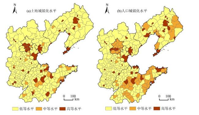
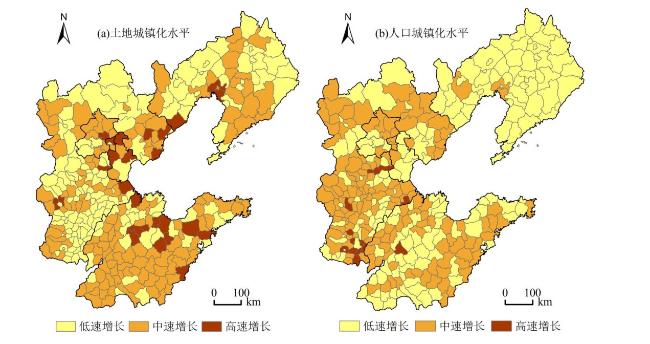
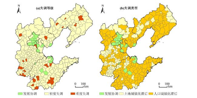
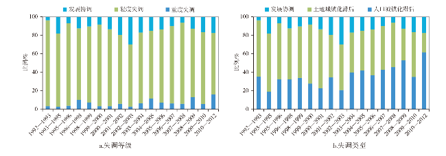
Based on the multi-source remote sensing data, GIS ancillary data and statistical data, this paper revealed the spatial-temporal evolution and uncoordinated development characteristics of land-population urbanization at the county level in Bohai Rim region in the past 20 years using the methods of GIS spatial analysis and index analysis. The research results showed as follows; Firstly, the land and population urbanization levels of the counties both were mainly at the low level, but the counties with medium to high land urbanization level were mainly distributed around the municipal districts, while the counties with medium to high population urbanization level were mainly continuously distributed in the developed areas. Secondly, the land and population urbanization levels both presented a significant growth trend, but the counties with high growth of land urbanization level were mainly distributed in the coastal zones and the capital cities, while the counties with high growth of population urbanization level were mainly distributed in Hebei province. Thirdly, about 94.56% of the counties presented uncoordinated development between land and population urbanization and their uncoordinated grades were mainly mild disorder, most of the population urbanization level belonged to lag types. Fourthly, the uncoordinated level presented as cyclical fluctuation and spirally rising trend, and the proportion of severe uncoordinated development had a small increase, while the proportion of lag-type population urbanization had a marked increase. These findings could provide references for optimizing the pattern of urbanization and promoting the coordinated development of land-population urbanization.
YANG Yang , MEI Jie . The Spatial-Temporal Evolution and Uncoordinated Development Characteristics of Land-Population Urbanization at the County Level in Bohai Rim Region[J]. Economic geography, 2019 , 39(7) : 205 -215 . DOI: 10.15957/j.cnki.jjdl.2019.07.023
表1 环渤海地区土地—人口城镇化水平分级标准Tab.1 Classification of land and population urbanization level in Bohai Rim from 1992 to 2012 |
| 类别 | 指标 | 等级 | 划分标准 | 取值范围/% |
|---|---|---|---|---|
| 土地城镇化 | 高等水平 | >2 | >5.30 | |
| 中等水平 | ~2 | 2.65~5.30 | ||
| 低等水平 | < | <2.65 | ||
| 高速增长 | >2 | >18.22 | ||
| 中速增长 | ~2 | 9.11~18.22 | ||
| 低速增长 | < | <9.11 | ||
| 人口城镇化 | 高等水平 | >2 | >51.06 | |
| 中等水平 | ~2 | 25.53~51.06 | ||
| 低等水平 | < | <25.53 | ||
| 高速增长 | >2 | >8.02 | ||
| 中速增长 | ~2 | 4.01%~8.02 | ||
| 低速增长 | < | <4.01 |
注: 和V分别为整个环渤海地区县域1992—2012年土地城镇化水平的平均值和年均增长率, 和W分别为整个环渤海地区县域1992—2012年人口城镇化水平的平均值和年均增长率。 |
表2 土地—人口城镇化水平发展失调等级与类型划分标准Tab.2 Coordination index and category of land-population urbanization level |
| 失调等级 | 失调类型 | ||
|---|---|---|---|
| (0.3,1] | 重度失调 | <0 | 土地城镇化滞后 |
| >0 | 人口城镇化滞后 | ||
| (0.2,0.3] | 轻度失调 | <0 | 土地城镇化滞后 |
| >0 | 人口城镇化滞后 | ||
| [0,0.2] | 发展协调 |
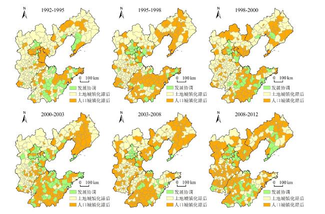
图5 环渤海地区县域1992—2012年土地—人口城镇化水平发展失调等级变化过程Fig.5 Uncoordinated grade of land-population urbanization in Bohai Rim at the county level from 1992 to 2012 |
| [1] |
李克强. 协调推进城镇化是实现现代化的重大战略选择[J]. 行政管理改革, 2012, 4(11):4-10.
|
| [2] |
姚士谋, 陆大道, 王聪, 等. 中国城镇化需要综合性的科学思维——探索适应中国国情的城镇化方式[J]. 地理研究, 2011, 30(11):1 947-1 955.
|
| [3] |
姚士谋, 陆大道, 陈振光, 等. 顺应我国国情条件的城镇化问题的严峻思考[J]. 经济地理, 2012, 32(5):1-6.
|
| [4] |
李力行. 中国的城市化水平:现状、挑战和应对[J]. 浙江社会科学, 2010, 26(12):27-34,42.
|
| [5] |
陆大道, 陈明星. 关于“国家新型城镇化规划(2014—2020)”编制大背景的几点认识[J]. 地理学报, 2015, 70(2):179-185.
|
| [6] |
刘彦随, 杨忍. 中国环渤海地区城乡发展转型格局测度[J]. 地理学报, 2015, 70(2):248-256.
|
| [7] |
范进, 赵定涛. 土地城镇化与人口城镇化协调性测定及其影响因素[J]. 经济学家, 2012, 24(5):61-67.
|
| [8] |
杨丽霞, 苑韶峰, 王雪禅. 人口城镇化与土地城镇化协调发展的空间差异研究——以浙江省69县市为例[J]. 中国土地科学, 2013, 27(11):18-22,30.
|
| [9] |
李子联. 人口城镇化滞后于土地城镇化之谜——来自中国省际面板数据的解释[J]. 中国人口·资源与环境, 2013, 23(11):94-101.
|
| [10] |
尹宏玲, 徐腾. 我国城市土地城镇化与人口城镇化失调特征及差异研究[J]. 城市规划学刊, 2013, 36(2):10-15.
|
| [11] |
潘爱民, 刘友金. 湘江流域人口城镇化与土地城镇化失调程度及特征研究[J]. 经济地理, 2014, 34(5):63-68.
|
| [12] |
严思齐, 吴群. 土地城镇化与人口城镇化的非协调性和互动关系[J]. 中国人口·资源与环境, 2016, 26(11):28-36.
|
| [13] |
陈春, 于立, 张锐杰, 等. 中国城镇化加速阶段中期土地城镇化与人口城镇化的协调程度[J]. 长江流域资源与环境, 2016, 25(11):1 654-1 662.
|
| [14] |
陈凤桂, 张虹鸥, 吴旗韬, 等. 我国土地城镇化与人口城镇化协调发展研究[J]. 人文地理, 2010, 25(5):53-58.
|
| [15] |
刘娟, 郑钦玉, 郭锐利, 等. 重庆市人口城镇化与土地城镇化协调发展评价[J]. 经济地理, 2012, 32(11):66-72.
|
| [16] |
崔许锋. 民族地区的人口城镇化与土地城镇化:非均衡性与空间异质性[J]. 中国人口·资源与环境, 2014, 24(8):63-72.
|
| [17] |
郭付友, 李诚固, 陈才, 等. 2003年以来东北地区人口城镇化与土地城镇化时空耦合特征[J]. 经济地理, 2015, 35(9):49-56.
|
| [18] |
林爱文, 樊星. 湖北省人口城镇化与土地城镇化协调发展分析[J]. 地域研究与开发, 2015, 34(6):14-18.
|
| [19] |
吕添贵, 吴次芳, 李洪义, 等. 人口城镇化与土地城镇化协调性测度及优化——以南昌市为例[J]. 地理科学, 2016, 36(2):239-246.
|
| [20] |
刘欢, 邓宏兵, 李小帆. 长江经济带人口城镇化与土地城镇化协调发展时空差异研究[J]. 中国人口·资源与环境, 2016, 26(5):160-166.
|
| [21] |
张鹏岩, 杨丹, 李二玲, 等. 人口城镇化与土地城镇化的耦合协调关系——以中原经济区为例[J]. 经济地理, 2017, 37(8):145-154.
|
| [22] |
杨洋, 何春阳, 赵媛媛, 等. 利用DMSP/OLS稳定夜间灯光数据提取城镇用地信息的分层阈值法研究[J]. 中国图象图形学报, 2011, 16(4):666-673.
|
| [23] |
|
| [24] |
|
| [25] |
杨洋, 李雅静, 黄庆旭, 等. 中国城市用地与人口规模分布时空动态比较——以环渤海地区为例[J]. 地理研究, 2016, 35(9):1 672-1 686.
|
| [26] |
杨忍, 刘彦随, 龙花楼. 中国环渤海地区人口—土地—产业非农化转型协同演化特征[J]. 地理研究, 2015, 34(3):475-486.
|
| [27] |
|
| [28] |
何春阳, 史培军, 李景刚, 等. 基于DMSP/OLS夜间灯光数据和统计数据的中国大陆20世纪90年代城市化空间过程重建研究[J]. 科学通报, 2006, 51(7):856-861.
|
| [29] |
杨洋, 马学广, 王晨. 基于夜间灯光数据的中国土地城镇化水平时空动态[J]. 人文地理, 2015, 30(5):91-98.
|
/
| 〈 |
|
〉 |
