
Approaches of Rural Spatial Planning and Governance under the Land Spatial Planning System:A Case Study of Four Typical Villages
Received date: 2020-08-14
Online published: 2025-04-25
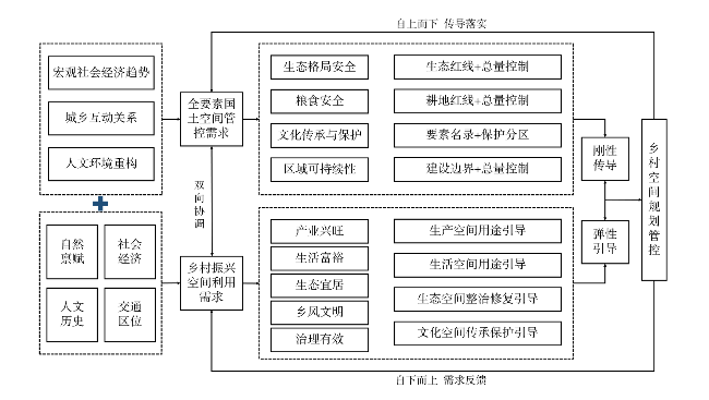
Traditional rural space varied from the homogeneity to the diversity and heterogeneity,it has many and complex problems on the rural spatial planning and governance,exploring the effective pathway of rural spatial planning and governance is an important part of land spatial planning. Based on the connotation of rural spatial concept and the demand logic of rural spatial planning and governance,this paper combines with the investigation of four-type villages( integration-type village,promotion-type village,protection-type village and remove and merger-type village) to explore the effective path of rural spatial planning and governance under the land spatial planning system. The results show that : 1) The rural space has the characteristics of complex diversity,regional difference and dynamic openness,and the rural spatial governance needs to face the demands of the total factor national space governance and the rural development space utilization under the background of land spatial planning system. 2) Founded on double demands to build rural spatial control system which involves basic-need area and special-superposition area,the rural management and control can be based on the regional dominant factors to define the basic-need area of rural space, which realizes the elasticity of the guiding as well as country space ecological line protection,the development strategy space,food security and other aspects of the implementation of the rigid control content. The designation of special-superposition area provides flexible guidance for construction activities and land resources within the area. 3) There are differences in the demand of rural spatial governance in the four-type villages which are integration-type village,promotion-type village,protection-type village and remove and merger-type village,so various use areas can be differentiated according to their spatial differentiation mechanism,and a targeted space access permit and development and utilization permit system can be constructed. Rural spatial planning and governance should be based on the characteristics of rural resource endowment and development transformation,governance system of rural spatial "basic-need area and special-superposition area" should meet dual demands,so as to propose differentiated rural spatial planning and governance zones and countermeasures consistent with village characteristics.
ZHU Peijuan , WANG Nan , ZHANG Yong , XING Xudong , LI Yuwei . Approaches of Rural Spatial Planning and Governance under the Land Spatial Planning System:A Case Study of Four Typical Villages[J]. Economic geography, 2021 , 41(4) : 201 -211 . DOI: 10.15957/j.cnki.jjdl.2021.04.024
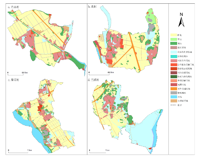
表1 案例村基本情况Tab.1 Characteristics of typical villages in research area |
| 典型村 | 肖山村 | 良村 | 黎屋村 | 兰溪村 |
|---|---|---|---|---|
| 人口密度(人/km2) | 2 368.42 | 2 479.44 | 2 109.49 | 1 317.67 |
| 人均建设用地面积(m2/人) | 81.59 | 105.76 | 84.34 | 92.63 |
| 区位条件 | 位于长岐镇南部,距离镇区10 km,与吴川市梅菉街道接壤,距离距吴川市中心仅3 km | 位于长岐镇西北部,距离镇区约1 km,距离吴川市区约10 km | 位于长岐镇南部,距离镇区约10 km,距离吴川市区约4 km | 位于长岐镇东南部,距离镇区约7 km,东与博铺街道相邻 |
| 现状产业 | 以农业种植和商贸业为主 | 以特色农业为主 | 以现代型农业为主 | 以淡水养殖业和商贸业为主 |
| 主要农作物 | 水稻、花生、蔬菜 | 水稻、蔬菜、花生、圆椒 | 蔬菜、辣椒、甜玉米、水稻、花生 | 水稻、花生、蔬菜 |
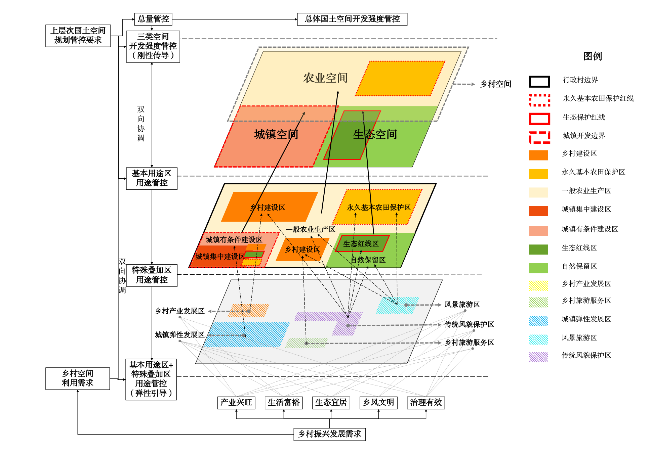
表2 基本用途区体系Tab.2 System of basic use area |
| 一级分区 | 二级分区 | 含义 | 管控手段 |
|---|---|---|---|
| 基本用途区 | 自然保留区 | 为径流调节、气候调节等生态功能划定的区域,以水域和其他土地为主 | 按县市照国土空间总体规划“三区三线”管控要求,通过总量控制、名录管控、边界控制刚性落实 |
| 生态红线区 | 以生态保护红线范围划定的区域 | ||
| 乡村建设区 | 为满足农民生活居住及生产配套为主的区域,以乡村建设用地为主 | ||
| 一般农业生产区 | 为满足农林牧渔等农业发展需要划定的区域,以耕地、林地、园地、坑塘水面等农用地为主 | ||
| 永久基本农田保护区 | 为永久基本农田保护红线划定的区域,以优质的耕地和其他农用地为主 | ||
| 城镇有条件建设区 | 为纳入城镇开发边界内,为应对城镇发展不确定性划定的乡村空间区域,必要时可进行城镇开发和集中建设,以城郊村为例 | ||
| 城镇集中建设区 | 为满足居民生产生活需要,允许集中连片建设的区域,如部分保留城中村 |
表3 特殊叠加区体系Tab.3 System of special overlay areas |
| 特殊叠加区 | 含义 | 管控手段 | 备注 |
|---|---|---|---|
| 城镇弹性发展区 | 为已纳入城镇开发边界内原乡村空间划定的区域,是乡村生产生活功能与城镇发展功能复合叠加的区域 | 边界管控:城镇开发边界 规则管控:明确城镇开发边界调整规则与管控要求,管控城镇发展区内开发建设行为,控制开发强度 | 当特殊叠加区与基本用途区相冲突时,采用基本用途区的管控规则 |
| 乡村产业发展区 | 为为满足产业发展需要复合于乡村建设区上的区域 | 规则管控:明确管控乡村产业发展区内开发建设行为,控制开发强度 | |
| 传统风貌保护区 | 为具有传统风貌保护价值的区域,农业生产生活空间与生态空间存在多重交叉现象 | 边界管控:落实到特殊用地 规则管控:明确传统风貌保护区管控要求、开发与保护行为规则 | |
| 风景旅游区 | 为叠合于生态空间与农业空间中的风景观赏、休憩、文化功能区域 | 名录管控:风景旅游区名录 边界管控:落实到特殊用地 规则管控:明确风景旅游区管控要求与开发建设行为 | |
| 乡村旅游服务区 | 为在乡村建设区上旅游服务功能的植入而产生的功能复合区域 | 规则管控:明确乡村旅游服务区管控要求与开发建设行为控制规则 |
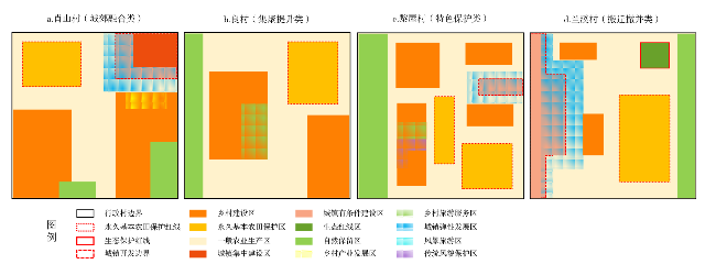
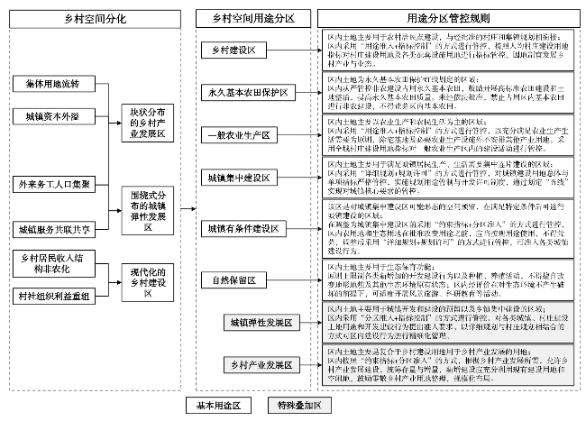
图5 城郊融合类肖山村空间用途管控规则Fig.5 Rules for the governance of space sse in Xiaoshan Village |
| [1] |
陈阳, 岳文泽, 张亮, 等. 国土空间规划视角下生态空间管制分区的理论思考[J]. 中国土地科学, 2020, 34(8):1-9.
|
| [2] |
周侃, 樊杰, 盛科荣. 国土空间管控的方法与途径[J]. 地理研究, 2019, 38(10):2527-2540.
|
| [3] |
林坚, 吴宇翔, 吴佳雨, 等. 论空间规划体系的构建——兼析空间规划、国土空间用途管制与自然资源监管的关系[J]. 城市规划, 2018, 42(5):9-17.
|
| [4] |
汪毅, 何淼. 新时期国土空间用途管制制度体系构建的几点建议[J]. 城市发展研究, 2020, 27(2):25-29.
|
| [5] |
杨忍, 刘彦随, 龙花楼, 等. 中国乡村转型重构研究进展与展望——逻辑主线与内容框架[J]. 地理科学进展, 2015(8):1019-1030.
|
| [6] |
|
| [7] |
孙莹, 张尚武. 我国乡村规划研究评述与展望[J]. 城市规划学刊, 2017(4):74-80.
|
| [8] |
|
| [9] |
|
| [10] |
|
| [11] |
|
| [12] |
杨忍. 广州市城郊典型乡村空间分化过程及机制[J]. 地理学报, 2019, 74(8):1622-1636.
|
| [13] |
王丹, 刘祖云. 国外乡村空间研究的进展与启示[J]. 地理科学进展, 2019, 38(12):1991-2002.
|
| [14] |
汪毅, 何淼. 大城市乡村地区的空间管控策略[J]. 规划师, 2018, 34(9):117-121.
|
| [15] |
陈明星, 梁龙武, 王振波, 等. 美丽中国与国土空间规划关系的地理学思考[J]. 地理学报, 2019, 74(12):2467-2481.
|
| [16] |
刘彦随. 中国新时代城乡融合与乡村振兴[J]. 地理学报, 2018, 73(4):637-650.
|
| [17] |
璩路路, 李裕瑞, 李琳娜, 等. 农牧交错带乡村空间发展类型及影响因素研究[J]. 经济地理, 2019, 39(10):153-161.
|
| [18] |
欧名豪, 丁冠乔, 郭杰, 等. 国土空间规划的多目标协同治理机制[J]. 中国土地科学, 2020, 34(5):8-17.
|
| [19] |
林坚, 武婷, 张叶笑, 等. 统一国土空间用途管制制度的思考[J]. 自然资源学报, 2019, 34(10):2200-2208.
|
| [20] |
戴柳燕, 周国华, 何兰. 乡村吸引力的概念及其形成机制[J]. 经济地理, 2019, 39(8):177-184.
|
| [21] |
屠爽爽, 周星颖, 龙花楼, 等. 乡村聚落空间演变和优化研究进展与展望[J]. 经济地理, 2019, 39(11):142-149.
|
| [22] |
李强, 汪伟, 张健. 美国金县乡村空间规划管控[J]. 国际城市规划, 2020, 35(1):147-153.
|
| [23] |
郭杰, 陈鑫, 赵雲泰, 等. 乡村空间统筹治理的村庄规划关键科学问题研究[J]. 中国土地科学, 2020, 34(5):76-85.
|
/
| 〈 |
|
〉 |