
Detailed Compilation of National Land Spatial Planning Based on Land Use Categorization
Received date: 2020-08-14
Online published: 2025-04-25
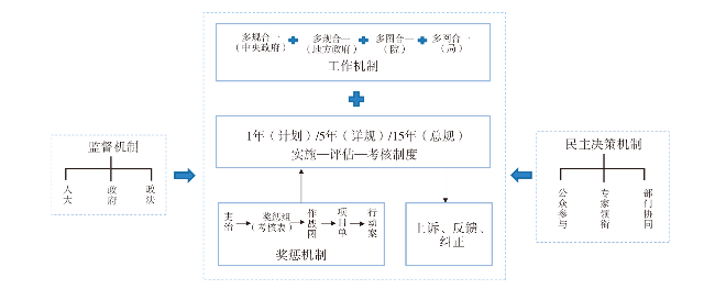
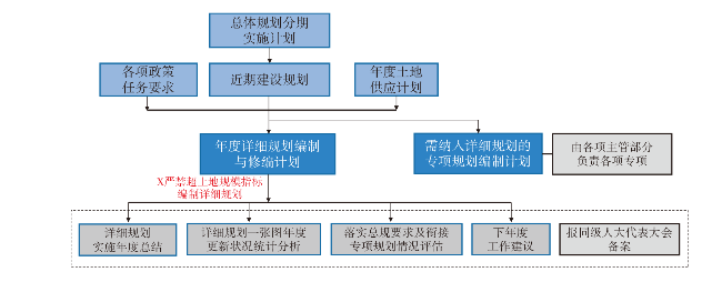
China is actively promoting the construction of the spatial planning system,and land classification as an important technical basis for planning and management is an important tool and means to achieve this goal. Based on this,this paper starts with land use classification,analyzes and summarizes the current land use classification standards,and analyzes and summarizes that there exist such problems as sector-led classification standards of the land use,coexistence of multiple standards,insufficient foresight and other issues,and propose a land use planning standards for spatial planning with concise and enhanced use control. Detailed planning,as management means of urban-rural planning and government spatial control,has a contradiction between the static nature of the formulation and the dynamic nature of urban-rural development. The implementation of the upper plan and the special plan for the connection are insufficient. The implementation,modification and dynamic maintenance after the formulation lack the corresponding management mechanism. In many places,frequent and large numbers of adjustment plans are difficult to implement,it currently lacks planning management of non-construction land,the boundaries of planning and management authority at all levels of departments are not absolutely clear,and there is a lack of overall consideration of non-construction land and construction land. Therefore,the reform of detailed planning and preparation is considered. Based on the land use classification,the possible ways to compile the detailed spatial planning of land are proposed: 1) The establishment of a detailed planning system should cover all types of natural resources. 2) The development and construction within the development boundary are carried out in accordance with the original detailed control planning,and others are determined by the special project or specific competent authority. 3) It establishes a detailed planning of scientific system process and dynamic operation mechanism. This paper will provide references for the exploration of national land spatial planning and the management of natural resources under the new situation,and better promote the construction of ecological civilization.
CAO Xiaoshu , OUYANG Shishu , LYU Chuanting . Detailed Compilation of National Land Spatial Planning Based on Land Use Categorization[J]. Economic geography, 2021 , 41(4) : 192 -200 . DOI: 10.15957/j.cnki.jjdl.2021.04.023
表1 用地分类体系Tab.1 Categorization of land use system |
| 序号 | 年份 | 名称 | 颁布单位 | 主要用途 |
|---|---|---|---|---|
| 1 | 1984 | 《土地利用现状调查技术规程》 | 全国农业区划委员会 | 土地资源调查、土地利用现状详查 |
| 2 | 1989 | 《城镇土地分类及含义》 | 原国家土地管理局 | 城镇地籍调查 |
| 3 | 1990 | 《城市用地分类与规划建设用地标准(GBJ 137-90)》 | 原国家建设部 | 城市的总体规划和城市用地统计 |
| 4 | 1993 | 《村镇规划标准 GB 50188-93》 | 国家技术监督局、原国家建设部 | 村镇规划 |
| 5 | 2001 | 《全国土地分类(试行)》 | 原国土资源部 | 土地数据调查、地籍调查 |
| 6 | 2007 | 《土地利用现状分类标准(GB/T 21010-2007)》 | 原国土资源部 | 土地调查、规划、评价、统计、登记及信息化管理 |
| 7 | 2010 | 《土地规划用途分类及含义》 | 原国土资源部 | 土地利用总体规划 |
| 8 | 2011 | 《城市用地分类与规划建设用地标准GB50137-2011》 | 住房和城乡建设部 | 城市总体规划、控制性详细规划 |
| 9 | 2014 | 《村庄规划用地分类指南》 | 住房和城乡建设部 | 村庄的规划编制、用地统计和用地管理 |
| 10 | 2017 | 《土地利用现状分类 GBT 21010-2017》 | 原国土资源部 | 土地调查、规划、审批、供应、整治、执法、评价、统计、登记及信息化管理 |
| 11 | 2019 | 《第三次全国国土调查技术规程(TD/T 1055-2019)》 | 自然资源部 | 土地利用现状调查、土地权属调查、专项用地调查与评价、国土调查数据库建设、统计汇总 |
表2 各部门用地分类规范标准对比分析Tab.2 Comparative analysis of land use classification standards of various departments |
| 部门 | 时间 | 名称 | 主要应用领域 | 关注重点 |
|---|---|---|---|---|
| 国土 部门 | 1984 | 《土地利用现状调查技术规程》 | 土地资源调查、土地利用现状详查 | 保护耕地与基本农田、控制建设用地、分类更注重非建设用地的细分 |
| 2001 | 《全国土地分类(试行)》 | 土地数据调查、地籍调查 | ||
| 2007 | 《土地利用现状分类标准(GB/T 21010-2007)》 | 土地调查、规划、评价、统计、登记及信息化管理 | ||
| 2010 | 《土地规划用途分类及含义》 | 土地利用总体规划 | ||
| 2011 | 《基本农田划定技术规程 TD/T 1032-2011》 | 基本农田划定 | ||
| 2017 | 《土地利用现状分类 GBT 21010-2017》 | 土地调查、规划、审批、供应、整治、执法、评价、统计、登记及信息化管理 | ||
| 住建 部门 | 1993 | 《村镇规划标准 GB 50188-93》 | 村镇规划 | 城镇内部用地功能与布局的引导和调控,对建设用地的划分更为细致 |
| 2008 | 《村庄整治技术规范(GB 50445-2008)》 | 村庄整治 | ||
| 2011 | 《城市用地分类与规划建设用地标准 GB50137-2011》 | 城市总体规划、控制性详细规划 | ||
| 2014 | 《村庄规划用地分类指南》 | 村庄的规划编制、用地统计和用地管理 | ||
| 发改 部门 | 2017 | 《全国主体功能区规划》 | 主体功能区规划 | 指引区域空间开发方向 |
| 环保 部门 | 1998 | 《饮用水水源保护区污染防治管理规定》 | 饮用水水源保护区规划 | 为物质空间环境建设提供生态底图 |
| 2000 | 《全国生态环境保护纲要》 | 生态保护规划 | ||
| 2017 | 《生态保护红线划定指南》 | 生态保护红线 | ||
| 2018 | 《饮用水水源保护区划分技术规范(HJ 338-2018)》 | 饮用水水源保护区规划 | ||
| 林业 部门 | 1993 | 《林地管理暂行办法》 | 林业发展规划 | 注重严控各类开发建设活动 |
| 2007 | 《国务院关于完善退耕还林政策的通知》 | 林业发展规划 | ||
| 2008 | 《国家湿地公园评估标准(LY/T 1754-2008)》 | 国家湿地公园的检查和验收 | ||
| 2009 | 《林地分类标准(LY/T 1812-2009)》 | 林业发展规划 | ||
| 2009 | 《湿地分类(GB/T 24708-2009)》 | 湿地综合调查、检测、管理、评价和保护规划 | ||
| 2011 | 《县级林地保护利用规划编制技术规程(LY/T1956-2011)》 | 全国县级行政区林地保护利用规划的编制 | ||
| 2012 | 《国家级森林公园总体规划规范》 | 森林公园总体规划 | ||
| 2017 | 《国家级自然保护区总体规划审批管理办法》 | 自然保护区总体规划 | ||
| 农业农 村部门 | 2010 | 《关于完善设施用地管理有关问题通知》 | 设施农用地管理 | 擅自将农用地改为建设用地 |
| 水利 部门 | 2007 | 《滩涂治理和海堤工程技术规范(SL-2007)》 | 滩涂治理和海堤工程的规划设计、新建、加固、扩建或改建 | 规范水利工程管理设计,提升水利工程管理水平 |
| 2017 | 《水利水电工程等级划分及洪水标准 SL 252-2017》 | 水利水电工程 | ||
| 2017 | 《水库工程管理设计规范(SL 106-2017)》 | 新建大、中型水库工程管理设计 |
表3 国土空间规划用地分类标准Tab.3 Categorization criteria of land use for national land spatial planning |
| 一级类 | 二级类 | 三级类 | 四级类 |
|---|---|---|---|
| 建设用地 | 城镇建设用地 | 居住用地 | 一类、二类、三类居住用地 |
| 公共管理与公共服务用地 | 行政办公用地、文化设施用地、教育科研用地、体育用地、医疗卫生用地、社会福利设施用地、文物古迹用地、外事用地、宗教设施用地 | ||
| 商业服务业设施用地 | 商业设施用地、商务设施用地、娱乐康体设施用地、公共设施营业网点用地、其他服务设施用地 | ||
| 工业用地 | 一类、二类、三类工业用地 | ||
| 物流仓储用地 | 一类、二类、三类物流仓储用地 | ||
| 道路与交通设施用地 | 城市道路用地、城市轨道交通用地、交通枢纽用地、交通场站用地 | ||
| 绿地与广场用地 | 公园绿地、防护绿地、广场用地 | ||
| 村庄建设用地 | 村庄住宅用地 | 住宅用地、混合式住宅用地 | |
| 村庄公共服务用地 | 村庄公共服务设施用地、村庄公共场地 | ||
| 村庄产业用地 | 村庄商业服务业设施用地、村庄生产仓储用地 | ||
| 村庄基础设施用地 | 村庄道路用地、村庄交通设施用地、村庄公用设施用地、村庄其他建设用地 | ||
| 区域基础设施用地 | 区域交通设施用地 | 铁路用地、公路用地、港口用地、机场用地、管道运输用地 | |
| 区域公用设施用地 | |||
| 其他建设用地 | 特殊用地、采矿用地等 | ||
| 非建设用地 | 农用地 | 耕地 | 水田、水浇地、旱地 |
| 园地 | 果园、茶园、橡胶园、其他园地 | ||
| 设施农用地 | 生产设施用地、附属设施用地 | ||
| 其他农用地 | 农村道路、田坎、坑塘沟渠 | ||
| 生态用地 | 湿地 | 红树林地、沼泽地、滩涂、盐山 | |
| 林地 | 乔木林地、竹林地、灌木林地、其他林地 | ||
| 草地 | 天然牧草地、人工牧草地、其他草地 | ||
| 水域 | 河流水面、湖泊水面、水库水面、冰川及永久积雪 | ||
| 自然保护地 | 国家公园、自然保护区、森林公园、世界自然遗产、地质遗迹保护 | ||
| 其他非建设用地 | 盐碱地、沙地、裸土地、裸岩石砾地 |
| [1] |
聂玉文, 王欢欢, 符太成, 等. 国土空间规划下用地分类体系探究[J]. 住宅与房地产, 2019(19):73-74.
|
| [2] |
杨保军, 陈鹏, 董珂, 等. 生态文明背景下的国土空间规划体系构建[J]. 城市规划学刊, 2019(4):16-23.
|
| [3] |
陈信旺, 万泉, 陈国瑞, 等. 林业与国土部门对林地界定的差异性分析——以福建省福安市为例[J]. 林业勘察设计, 2013(2):1-5.
|
| [4] |
柴明. “两规”协调背景下的城乡用地分类与土地规划分类的对接研究[J]. 规划师, 2012, 28(11):96-100.
|
| [5] |
胡进. 明确分类标准梳理规划用地——上海市开展城市用地分类与土地利用现状分类对接研究的探索[J]. 中国土地, 2013(6):39-41.
|
| [6] |
孔江伟, 曾坚, 高梦溪. 生态文明视角下国土空间分类体系探讨[J]. 规划师, 2019, 35(23):60-68.
|
| [7] |
李升发, 陈伟莲, 张虹鸥. 关于我国空间规划用地分类的思考[J]. 城市与区域规划研究, 2017, 9(4):59-71.
|
| [8] |
李皓晟, 田心怡, 黄月恒. 全域全要素国土空间规划用地分类研究[J]. 中国土地, 2019(12):45-47.
|
| [9] |
张永姣, 方创琳. 空间规划协调与多规合一研究:评述与展望[J]. 城市规划学刊, 2016(2):78-87.
|
| [10] |
|
| [11] |
|
| [12] |
|
| [13] |
|
| [14] |
|
| [15] |
吕传廷, 许骏, 孙施文, 等. 控规三十年:得失与展望[J]. 城市规划, 2017, 041(3):109-116.
|
| [16] |
戚冬瑾, 周剑云. 我国城市用地分类的地方性探索[J]. 城市规划, 2017, 41(5):59-68.
|
| [17] |
李舒. 控制性详细规划分级编制的借鉴和思考[J]. 城市建筑, 2020, 17(14):20-21.
|
| [18] |
张艳芳, 刘治彦. 国家治理现代化视角下构建空间规划体系的着力点[J]. 城乡规划, 2018(5):21-26.
|
| [19] |
袁奇峰, 谭诗敏, 李刚, 等. 空间规划:为何?何为?何去?[J]. 规划师, 2018, 34(7):11-17.
|
| [20] |
徐耀宽, 刘楚君. “一张蓝图干到底”之下控规编制与管理的对策——以广州为例[J]. 中外建筑, 2018(6):68-70.
|
| [21] |
林坚, 武婷, 张叶笑, 等. 统一国土空间用途管制制度的思考[J]. 自然资源学报, 2019, 34(10):2200-2208.
|
| [22] |
余亮亮, 蔡银莺. 国土空间规划管制与区域经济协调发展研究——一个分析框架[J]. 自然资源学报, 2017, 32(8):1445-1456.
|
| [23] |
朱江, 杨箐丛, 詹浩. 面向全域土地用途管制的空间规划实践探索——以宁夏回族自治区平罗县空间规划为例[J]. 城市建筑, 2018(18):22-26.
|
| [24] |
陈小卉, 何常清. 制度变迁背景下的省级空间治理思考——以江苏省为例[J]. 城乡规划, 2018(5):27-34.
|
| [25] |
曹小曙. 基于人地耦合系统的国土空间重塑[J]. 自然资源学报, 2019, 34(10):2051-2059.
|
| [26] |
曹小曙. 地理系统与地理治理[J]. 科技导报, 2020, 38(13):32-38.
|
| [27] |
赵广英, 李晨. 国土空间规划体系下的详细规划技术改革思路[J]. 城市规划学刊, 2019(4):37-46.
|
| [28] |
毕云龙, 徐小黎, 李勇. 浅析国土空间用途管制制度建设[J]. 中国土地, 2019(8):30-33.
|
| [29] |
黄征学, 蒋仁开, 吴九兴. 国土空间用途管制的演进历程,发展趋势与政策创新[J]. 中国土地科学, 2019, 33(6):1-9.
|
| [30] |
陈志诚, 樊尘禹. 城市层面国土空间规划体系改革实践与思考——以厦门市为例[J]. 城市规划, 2020, 44(2):59-67.
|
| [31] |
谢英挺, 王伟. 从“多规合一”到空间规划体系重构[J]. 城市规划学刊, 2015(3):15-21.
|
| [32] |
朱江, 邓木林, 潘安. “三规合一”:探索空间规划的秩序和调控合力[J]. 城市规划, 2015, 39(1):41-47.
|
/
| 〈 |
|
〉 |