
County-Level Highway Network Centrality of Urban Agglomerations and Its Influencing Factors in the Middle Reaches of the Yangtze River
Received date: 2018-10-18
Revised date: 2019-01-23
Online published: 2025-04-23
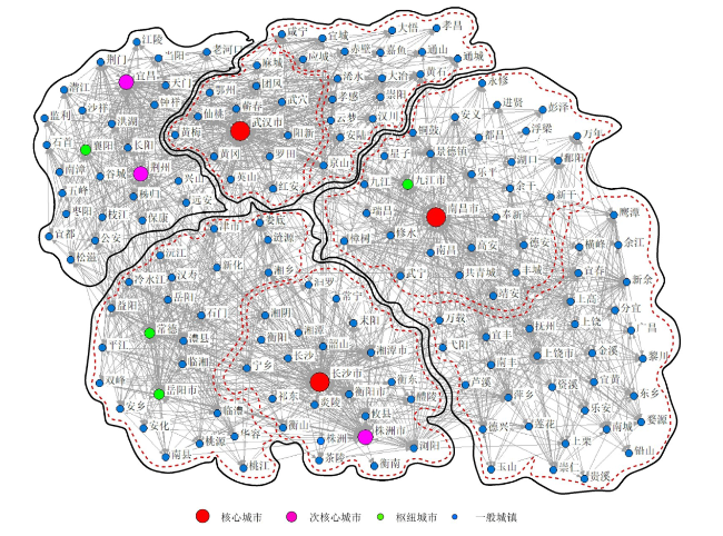
Based on the data of county roads of urban agglomerations in the middle reaches of the Yangtze River and utilizing the social network analysis method and geographical detector, this paper analyzes the urban centrality and influencing factors of the urban agglomerations in the middle reaches of the Yangtze River from the overall highway network in the county level, urban centrality and influencing factors. The results show that: 1) The county-level network density of urban agglomerations in the middle reaches of the Yangtze River is high, and the road network is initially developed. The Changsha-Zhuzhou-Xiangtan urban agglomeration as a sub-city group is the intermediary of the whole network, the overall situation is relatively loose in Wuhan metropolitan area and the Poyang Lake urban agglomeration. 2) The core cities have certain "shadowing effect" and "siphon effect" on the surrounding towns, network centrality is generally strong in the prefecture-level cities, it grows slow in the network of small towns, and the cohesive subgroups show the characteristics of "four zones and seven subgroups" as a whole in the middle reaches of the Yangtze River. 3) geographical detector shows that economy, population size, urban administrative level, industrial structure, capital investment, market vitality and payment level have a significant influence on the town centrality under the traffic flow network, but the level of residents' payments and industrial structure play a relatively weak role. It puts forward that government should enhance the core urban concentration and radiation capacity, optimize regional division of the urban agglomeration, nurture sub-centers and pivot cities and promote regional cluster development, which are in favor of joint development of urban agglomeration.
GUO Weidong , ZHONG Yexi , FENG Xinghua , LI Jianxin . County-Level Highway Network Centrality of Urban Agglomerations and Its Influencing Factors in the Middle Reaches of the Yangtze River[J]. Economic geography, 2019 , 39(4) : 34 -42 . DOI: 10.15957/j.cnki.jjdl.2019.04.005
表1 长江中游城市群公路客运联系网络密度表Tab.1 Network Density of urban agglomerations in the middle reaches of the Yangtze River |
| 密度 | 环鄱阳湖城市群 | 长株潭城市群 | 武汉都市圈 |
|---|---|---|---|
| 环鄱阳湖城市群 | 0.67 | 0.25 | 0.08 |
| 长株潭城市群 | 0.19 | 0.76 | 0.41 |
| 武汉都市圈 | 0.06 | 0.39 | 0.73 |
表2 长江中游城市群城镇中心性影响因素地理探测结果表Tab.2 Results of influencing factors of urban centrality in urban agglomerations in the middle reaches of the Yangtze River based on the geographical detector model |
| 影响因子 | 程度中心性 | 中介中心性 | 综合中心性 | |||||
|---|---|---|---|---|---|---|---|---|
| q statistic | p value | q statistic | p value | q statistic | p value | |||
| GDP | 0.6953 | 0.0000 | 0.4835 | 0.0000 | 0.5450 | 0.0000 | ||
| 年末人口总数 | 0.5200 | 0.0000 | 0.6859 | 0.0000 | 0.6776 | 0.0000 | ||
| 行政级别 | 0.8286 | 0.0000 | 0.9141 | 0.0000 | 0.9171 | 0.0000 | ||
| 社会消费品零售总额 | 0.7220 | 0.0000 | 0.6037 | 0.0000 | 0.6439 | 0.0000 | ||
| 第三产业产值 | 0.4730 | 0.0000 | 0.4422 | 0.0000 | 0.4715 | 0.0000 | ||
| 年末金融机构各项贷款余额 | 0.8442 | 0.0000 | 0.9277 | 0.0000 | 0.9332 | 0.0000 | ||
| 财政支出 | 0.7145 | 0.0000 | 0.9168 | 0.0000 | 0.9039 | 0.0000 | ||
| 城镇居民人均可支配收入 | 0.3718 | 0.0000 | 0.4725 | 0.0000 | 0.4681 | 0.0000 | ||
| [1] |
|
| [2] |
|
| [3] |
|
| [4] |
|
| [5] |
陈田. 我国城市经济影响区域系统的初步分析[J]. 地理学报, 1987, 42(4):308-318.
|
| [6] |
顾朝林. 城市经济区理论与应用[M]. 吉林: 吉林科学技术出版社,1991.
|
| [7] |
王法曾. 建立城市体系等级层次的理论和方法———以河南省城市体系为例[J]. 地域研究与开发, 1993, 12(2):13-17.
|
| [8] |
周一星, 张莉, 武悦. 城市中心性与我国城市中心性的等级体系[J]. 地域研究与开发, 2001, 20(4):1-5.
|
| [9] |
|
| [10] |
|
| [11] |
钟柯, 肖昱, 许珺, 等. 基于列车运行网络的中国城市中心性分析[J]. 地球信息科学, 2012, 14(1):85-93.
|
| [12] |
赵映慧, 姜博, 郭豪, 等. 基于公共客运的东北地区城市陆路网络联系与中心性分析[J]. 经济地理, 2016, 36(2):67-73.
|
| [13] |
熊丽芳, 甄峰, 王波, 等. 基于百度指数的长三角核心区城市网络特征研究[J]. 经济地理, 2013, 33(7):67-73.
|
| [14] |
董超, 修春亮, 魏冶. 基于通信流的吉林省流空间网络格局[J]. 地理学报, 2014, 69(4):510-519.
|
| [15] |
叶磊, 段学军, 欧向军. 基于交通信息流的江苏省流空间网络结构研究[J]. 地理科学, 2015, 35(10):1 230-1 237.
|
| [16] |
郭卫东, 钟业喜, 傅钰. 长江中游城市群网络结构及其效率[J]. 企业经济, 2018(1):163-170.
|
| [17] |
|
| [18] |
|
| [19] |
莫辉辉, 金凤君, 刘毅, 等. 机场体系中心性的网络分析方法与实证[J]. 地理科学, 2010, 30(2):204-212.
|
| [20] |
蔡莉丽, 马学广, 陈伟劲, 等. 基于客运交通流的珠三角城市区域功能多中心特征研究[J]. 经济地理, 2013, 33(11):52-57.
|
| [21] |
冯兴华, 钟业喜. 长江经济带城市网络结构演变特征[J]. 学习与实践, 2018(10):46-55.
|
| [22] |
钟业喜, 朱治州. 长江经济带土地利用及其生态系统服务价值演变研究[J]. 江西师范大学学报:哲学社会科学版, 2018, 51(3):100-107.
|
| [23] |
柯文前, 陆玉麒, 朱宇, 等. 交通流网络的时空特征解析——基于张量分解方法视角[J]. 地理科学, 2016, 36(11):1 679-1 687.
|
| [24] |
|
| [25] |
|
| [26] |
赵梓渝, 魏冶, 庞瑞秋, 等. 基于人口省际流动的中国城市网络转变中心性与控制力研究——兼论递归理论用于城市网络研究的条件性[J]. 地理学报, 2017, 72(6):1 032-1 048.
|
| [27] |
|
| [28] |
王劲峰, 徐成东. 地理探测器:原理与展望[J]. 地理学报, 2017, 72(1):116-134.
|
| [29] |
刘彦随, 李进涛. 中国县域农村贫困化分异机制的地理探测与优化决策[J]. 地理学报, 2017, 72(1):161-173.
|
| [30] |
胡丹, 舒晓波, 尧波, 等. 江西省县域人均粮食占有量的时空格局演变[J]. 地域研究与开发, 2014, 33(4):157-162.
|
| [31] |
张宇星. 城市和城市群形态的空间分形特性[J]. 新建筑, 1995(3):42-46.
|
| [32] |
钟业喜, 陆玉麒. 基于铁路网络的中国城市等级体系与分布格局[J]. 地理研究, 2011, 30(5):785-794.
|
| [33] |
曾鹏, 秦艳辉. 城市行政级别、产业集聚对外商直接投资的影响[J]. 国际贸易问题, 2017(1):104-115.
|
| [34] |
柳坤, 申玉铭. 国内外区域空间相互作用研究进展[J]. 世界地理研究, 2014, 23(1):73-83.
|
| [35] |
李小建. 经济地理学(第二版)[M]. 北京: 高等教育出版社, 2006.
|
/
| 〈 |
|
〉 |

