
Spatial Correlation and Coupling Path between Freeway Flow and Tourism Flow of Scenic Spot in Jiangsu Province
Received date: 2020-02-15
Revised date: 2020-11-06
Online published: 2025-04-23
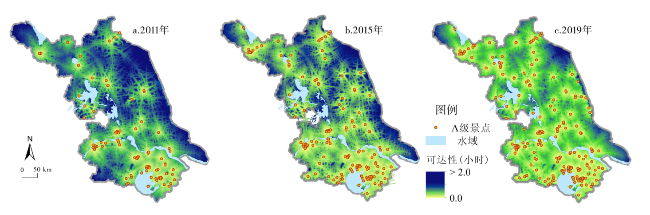
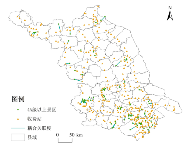
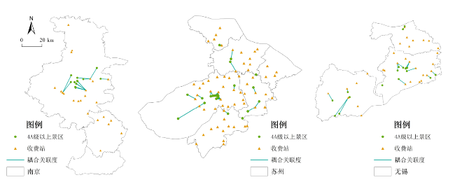
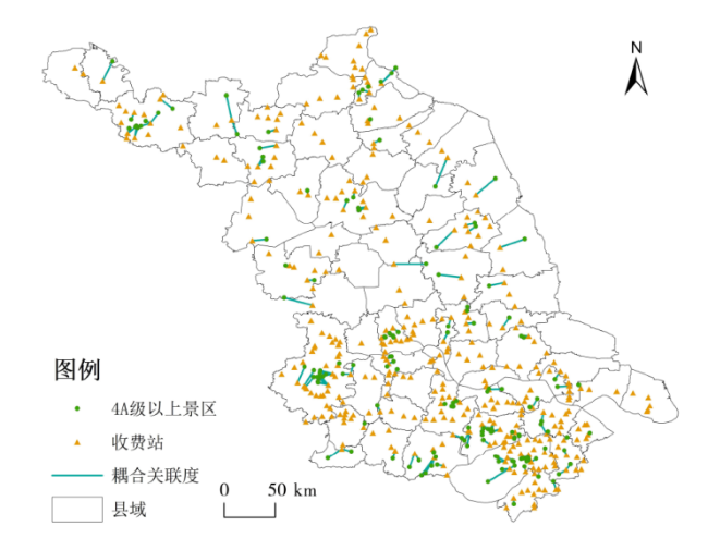
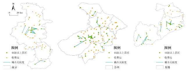
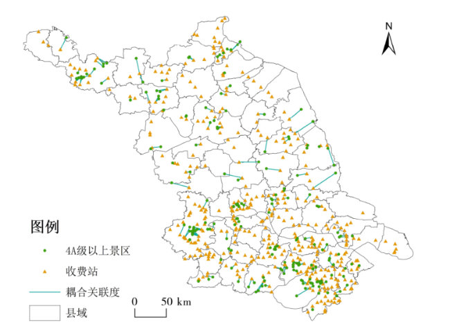
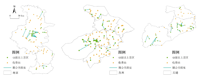
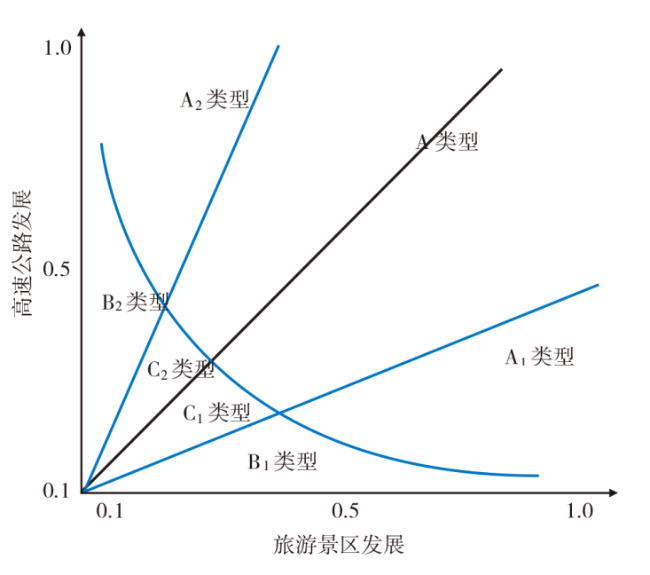
Mobility not only breaks through the restriction of traditional "place space" and "regional difference",but also becomes an important form of connotation interpretation of "flow space" and "regional relationship",and becomes the dominant regional spatial logic. On the basis of the fine data of the expressway network toll collection,this paper analyzes the accessibility of the tourist scenic spots,explores the spatial relationship between the expressway flow and the scenic spot tourism flow applying the coupling correlation model and puts forward the coupling path of the coordinated development of the expressway and the scenic spot. The results show that: 1) From 2011 to 2019,the intra-provincial accessibility of the scenic spots was gradually improved in Jiangsu Province,and the best places of accessibility were mainly distributed in Suzhou and Wuxi,where the shortest drive is less than half an hour. Better places of accessibility were distributed in Zhenjiang,Changzhou and Nanjing where were located in G42 along the Yangtze River. 2) Based on the coupling relationship between freeway flow and tourism flow in scenic spots,their spatial relationship successively presents the characteristics of decentralized association and agglomeration association of inner city. The agglomeration association of inner city becomes more relevant,more dense,which is mainly attributable to the continuous improvement of the highway network and the driving effect of the surrounding scenic areas.
CAO Fangdong , HUANG Zhenfang , HUANG Rui , XU Min . Spatial Correlation and Coupling Path between Freeway Flow and Tourism Flow of Scenic Spot in Jiangsu Province[J]. Economic geography, 2021 , 41(1) : 232 -240 . DOI: 10.15957/j.cnki.jjdl.2021.01.026
表1 道路速度的赋值(km/h)Tab.1 The set speed of different roads (km/h) |
| 高速公路 | 国道 | 省道 | 县道 | 默认值 | 河流与湖泊 |
|---|---|---|---|---|---|
| 100 | 60 | 50 | 40 | 5 | 0 |
表2 耦合协调度值等级划分标准Tab.2 Criteria for ranking of coupling coordination degree |
| 协调度(D) | 协调等级 | 协调度(D) | 协调等级 |
|---|---|---|---|
| 极度失调 | 勉强协调 | ||
| 严重失调 | 初级协调 | ||
| 中度失调 | 中级协调 | ||
| 轻度失调 | 良好协调 | ||
| 濒临失调 | 优质协调 |
| [1] |
王姣娥, 杜德林, 金凤君. 多元交通流视角下的空间级联系比较与地理空间约束[J]. 地理学报, 2019, 74(12):2482-2494.
|
| [2] |
|
| [3] |
|
| [4] |
|
| [5] |
|
| [6] |
|
| [7] |
|
| [8] |
|
| [9] |
|
| [10] |
|
| [11] |
|
| [12] |
|
| [13] |
|
| [14] |
吴晋峰, 潘旭莉. 入境旅游流网络与航空网络的关系研究[J]. 旅游学刊, 2010, 25(11):39-43.
|
| [15] |
王兆峰. 入境旅游流与航空运输网络协同演化及差异分析[J]. 地理研究, 2012, 31(7):1328-1338.
|
| [16] |
汪德根, 陈田, 陆林, 等. 区域旅游流空间结构的高铁效应及机理——以中国京沪高铁为例[J]. 地理学报, 2015, 72(2):214-233.
|
| [17] |
陈晓, 李悦铮. 城市交通与旅游协调发展定量评价——以大连市为例[J]. 旅游学刊, 2008, 23(2):60-64.
|
| [18] |
曹芳东, 黄震方, 吴江, 等. 国家级风景名胜区旅游效率测度与区位可达性分析[J]. 地理学报, 2012, 67(12):1686-1697.
|
| [19] |
靳诚, 陆玉麒, 张莉, 等. 基于路网结构的旅游景点可达性分析——以南京市为例[J]. 地理研究, 2009, 28(1):246-258.
|
| [20] |
郭向阳, 穆学青, 明庆忠, 等. 旅游地快速交通优势度与旅游流强度的空间耦合分析[J]. 地理研究, 2019, 38(5):1119-1135.
|
| [21] |
刘安乐, 王成, 杨承玥. 边疆山区旅游城市的交通与旅游发展耦合关系——以丽江市为实证案例[J]. 经济地理, 2018, 38(1):196-203.
|
| [22] |
余青, 胡晓冉, 刘志敏, 等. 风景道的规划设计——以鄂尔多斯风景道为例[J]. 旅游学刊, 2002, 17(10):61-66.
|
| [23] |
吴必虎, 李咪咪. 小兴安岭风景道旅游景观评价[J]. 地理学报, 2002, 57(2):214-222.
|
| [24] |
余菲菲, 胡文海, 荣慧芳. 中小城市旅游经济与交通耦合协调发展研究——以池州市为例[J]. 地理科学, 2015, 35(9):1116-1122.
|
| [25] |
刘康, 王坤, 樊文琴, 等. 民族山区旅游景区空间分布特征及其影响机制研究——以贵州省为例[J]. 湖南师范大学自然科学学报, 2019, 42(5):17-25.
|
| [26] |
叶茂, 王兆峰. 武陵山区交通通达性与旅游经济联系的耦合协调分析[J]. 经济地理, 2018, 38(1):196-203.
|
| [27] |
蒋小玉, 李永文. 海南省交通系统与旅游系统相关性及协调发展研究[J]. 河南大学学报:自然科学版, 2014, 44(6):677-682,705.
|
| [28] |
方世巧, 马耀峰, 李天顺, 等. 基于百度搜索的西安市A级景区信息与旅游流耦合分析[J]. 干旱区资源与环境, 2012, 26(8):190-194.
|
| [29] |
琚胜利, 陶卓民, 韩彦林. 南京乡村旅游景区游客网络关注与景区引力耦合协调度[J]. 经济地理, 2017, 37(11):220-228.
|
| [30] |
周迪, 王雪芹. 中国碳排放效率与产业结构升级的耦合度及耦合路径[J]. 自然资源学报, 2019, 34(11):2305-2316.
|
/
| 〈 |
|
〉 |