
Spatio-Temporal Evolution and Driving Forces of Rural Settlements Under the Background of Rapid Urbanization:A Case Study of Haikou City
Received date: 2019-12-04
Revised date: 2020-07-07
Online published: 2025-04-21
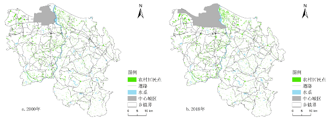
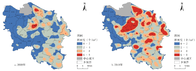
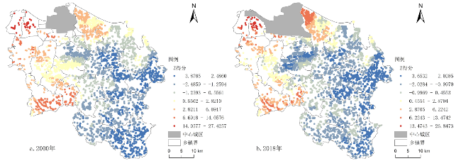
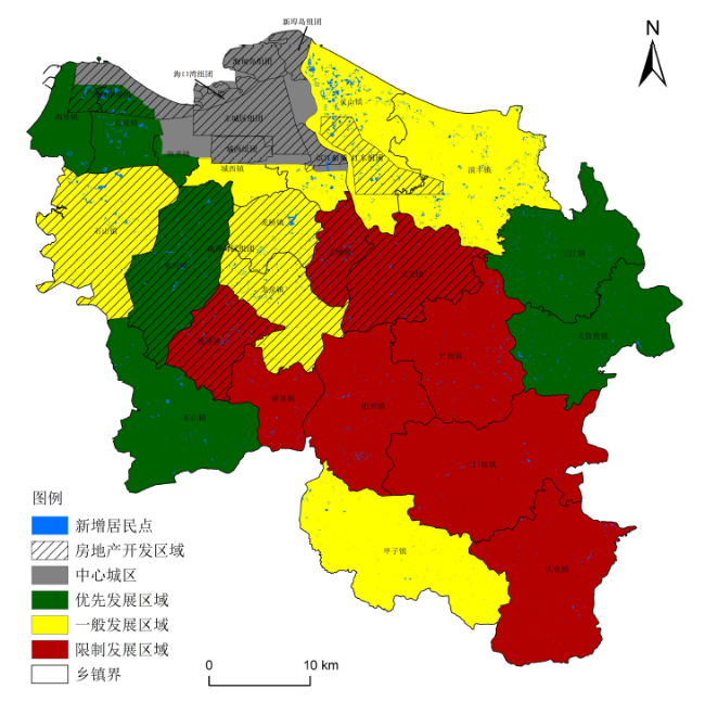
Based on remote sensing image classification and data interpretation,the spatio-temporal evolution characteristics and driving forces of rural settlements in Haikou City between 2000 and 2018 were quantitatively identified using the methods of the Kernel Density estimation,exploratory spatial data analysis and geographic detectors. Results showed that: 1) the number and area of the rural settlements have increased greatly in the past 20 years,and showed the character of "dense in the east while spare in the west" and spatial pattern of high-density small-scale agglomeration coexisting with low-density large-scale agglomeration. The scope of high-density areas has continuously expanded,and the distribution density has been significantly attenuated from the adjacent central urban areas to the east and south. Besides,the rural settlements tended to be relatively scattered,and the newly added residential areas were mainly located in the east and south of Haikou City with small and scattered features. 2) The spatial evolution of rural settlements in Haikou City is influenced by natural,location and policy factors. Among which,location factors have the most significant impact on the spatial pattern of rural settlements evolution. Especially,the road network density,accessibility to the center of the downtown area,and distance to the main road are the main driving forces of the spatial distribution of rural settlements. In addition,real estate development,various land use planning,protection and restriction policies also play important roles on the development and evolution of rural settlements.
SONG Wei , CHENG Yeqing , LIN Dan , YU Zhenxin , LUO Qiuge , ZHANG Jinping . Spatio-Temporal Evolution and Driving Forces of Rural Settlements Under the Background of Rapid Urbanization:A Case Study of Haikou City[J]. Economic geography, 2020 , 40(10) : 183 -190 . DOI: 10.15957/j.cnki.jjdl.2020.10.022
表1 不同高程范围内乡村居民点分布特征Tab.1 Rural settlements in different elevation zones in 2000 and 2018 |
| 指标名称 | Elevation<36 m | 36≤Elevation≤71 m | Elevation>71 m | |||||
|---|---|---|---|---|---|---|---|---|
| 2000 | 2018 | 2000 | 2018 | 2000 | 2018 | |||
| 居民点个数 | 2 255 | 3 877 | 1 782 | 3 002 | 1 008 | 1 446 | ||
| 个数百分比(%) | 44.70 | 46.57 | 35.32 | 36.06 | 19.98 | 17.37 | ||
| 面积(km²) | 24.42 | 54.14 | 17.49 | 25.72 | 6.12 | 14.31 | ||
| 面积百分比(%) | 50.84 | 57.49 | 36.42 | 27.32 | 12.74 | 15.19 | ||
| 平均面积(km²/个) | 0.011 | 0.014 | 0.010 | 0.009 | 0.006 | 0.010 | ||
表2 不同坡度范围内乡村居民点分布特征Tab.2 Rural settlements in different slope zones from 2000 to 2018 |
| 指标名称 | SLOPE<3.63° | 3.63°≤SLOPE≤7.07° | SLOPE>7.07° | |||||
|---|---|---|---|---|---|---|---|---|
| 2000 | 2018 | 2000 | 2018 | 2000 | 2018 | |||
| 居民点个数 | 2405 | 4160 | 1925 | 3080 | 715 | 1085 | ||
| 个数百分比(%) | 47.67 | 49.97 | 38.16 | 37.00 | 14.17 | 13.03 | ||
| 面积(km²) | 26.13 | 55.16 | 18.22 | 30.66 | 3.68 | 8.34 | ||
| 面积百分比(%) | 54.40 | 58.58 | 37.93 | 32.56 | 7.67 | 8.86 | ||
| 平均面积(km²/个) | 0.011 | 0.013 | 0.0010 | 0.010 | 0.005 | 0.008 | ||
表3 距离主要公路不同范围内乡村居民点分布特征Tab.3 Distribution characteristics of rural settlements in different distance from major highways |
| 指标名称 | 0~500 m | 500~1 000 m | 1 000~1 500 m | 1 500~2 000 m | >2 000 m | |||||||||
|---|---|---|---|---|---|---|---|---|---|---|---|---|---|---|
| 2000 | 2018 | 2000 | 2018 | 2000 | 2018 | 2000 | 2018 | 2000 | 2018 | |||||
| 居民点个数 | 2 507 | 4 295 | 1 212 | 1 840 | 668 | 1 080 | 359 | 598 | 299 | 512 | ||||
| 个数占比(%) | 49.69 | 51.59 | 24.02 | 22.10 | 13.24 | 12.98 | 7.12 | 7.18 | 5.93 | 6.15 | ||||
| 面积(km²) | 37.47 | 55.16 | 13.33 | 15.97 | 7.10 | 9.47 | 3.52 | 6.69 | 3.58 | 6.87 | ||||
| 面积占比(%) | 57.65 | 58.58 | 20.50 | 16.96 | 10.92 | 10.06 | 5.42 | 7.10 | 5.51 | 7.30 | ||||
| 平均面积(km²/个) | 0.015 | 0.013 | 0.011 | 0.009 | 0.011 | 0.009 | 0.010 | 0.011 | 0.012 | 0.013 | ||||
表4 距离主干河流不同距离的乡村居民点分布特征Tab.4 Distribution characteristics of rural settlements in different distances from the main river |
| 指标名称 | 0~1 000 m | 1 000~2 000 m | 2 000~3 000 m | 3 000~4 000 m | >4 000 m | |||||||||
|---|---|---|---|---|---|---|---|---|---|---|---|---|---|---|
| 2000 | 2018 | 2000 | 2018 | 2000 | 2018 | 2000 | 2018 | 2000 | 2018 | |||||
| 居民点个数 | 2 297 | 3 518 | 1 439 | 2 467 | 762 | 1 225 | 320 | 594 | 227 | 521 | ||||
| 个数占比(%) | 45.53 | 42.26 | 28.52 | 29.63 | 15.10 | 14.71 | 6.34 | 7.14 | 4.50 | 6.26 | ||||
| 面积(km²) | 19.82 | 40.72 | 12.63 | 26.64 | 7.63 | 15.40 | 4.70 | 7.33 | 3.25 | 4.07 | ||||
| 面积占比(%) | 41.27 | 43.25 | 26.30 | 28.29 | 15.89 | 16.35 | 9.79 | 7.78 | 6.77 | 4.32 | ||||
| 平均面积(km²/个) | 0.009 | 0.012 | 0.009 | 0.011 | 0.010 | 0.013 | 0.015 | 0.013 | 0.014 | 0.008 | ||||
| [1] |
吴传钧. 论地理学的研究核心——人地关系地域系统[J]. 经济地理, 1991, 11(3):1-6.
|
| [2] |
|
| [3] |
|
| [4] |
|
| [5] |
|
| [6] |
|
| [7] |
龙花楼, 李裕瑞, 刘彦随. 中国空心化村庄演化特征及其动力机制[J]. 地理学报, 2009, 64(10):1203-1 213.
|
| [8] |
刘彦随, 李进涛. 中国县域乡村贫困化分异机制的地理探测与优化决策[J]. 地理学报, 2017, 72(1):161-173.
|
| [9] |
海贝贝, 李小建, 许家伟. 巩义市乡村居民点空间格局演变及其影响因素[J]. 地理研究, 2013, 32(12):2257-2 269.
|
| [10] |
谭雪兰, 钟艳英, 段建南, 等. 快速城市化进程中乡村居民点用地变化及驱动力研究——以长株潭城市群为例[J]. 地理科学, 2014, 34(3):309-315.
|
| [11] |
杨勇, 邓祥征, 吴锋, 等. 华北平原乡村居民点演变及社会经济影响因素分析[J]. 人文地理, 2019, 34(2):116-124.
|
| [12] |
|
| [13] |
李红波, 张小林, 吴江国, 等. 苏南地区乡村聚落空间格局及其驱动机制[J]. 地理科学, 2014, 34(4):438-446.
|
| [14] |
陈宗峰, 李裕瑞, 刘彦随. 黄土丘陵沟壑区乡村聚落分布格局特征与类型[J]. 农业工程学报, 2017, 33(14):266-274,316.
|
| [15] |
杨忍. 基于自然主控因子和道路可达性的广东省乡村聚落空间分布特征及影响因素[J]. 地理学报, 2017, 72(10):1859-1 871.
|
| [16] |
周国华, 贺艳华, 唐承丽, 等. 中国乡村聚居演变的驱动机制及态势分析[J]. 地理学报, 2011, 66(4):515-524.
|
| [17] |
王兆林, 杨庆媛, 李计, 等. 山地都市边缘区乡村居民点布局优化策略——以重庆渝北区石船镇为例[J]. 经济地理, 2019, 39(9):182-190.
|
| [18] |
|
| [19] |
|
| [20] |
|
| [21] |
|
| [22] |
李全林, 马晓冬, 沈一. 苏北地区乡村聚落的空间格局[J]. 地理研究, 2012, 31(1):144-154.
|
| [23] |
李云强, 齐伟, 王丹, 等. GIS支持下山区县域乡村居民点分布特征研究——以栖霞市为例[J]. 地理与地理信息科学, 2011, 27(3):73-77.
|
| [24] |
钟紫玲, 王占岐, 李伟松. 基于Voronoi图与景观指数法的山区乡村居民点空间分布特征及其影响因素[J]. 水土保持研究, 2014, 21(2):211-216.
|
| [25] |
|
| [26] |
任平, 洪步庭, 刘寅, 等. 基于RS与GIS的乡村居民点空间变化特征与景观格局影响研究[J]. 生态学报, 2014, 34(12):3331-3 340.
|
| [27] |
程垠煜. 海南国际旅游岛建设背景下土地利用格局研究[D]. 兰州: 兰州大学, 2015.
|
| [28] |
王劲峰, 徐成东. 地理探测器:原理与展望[J]. 地理学报, 2017, 72(1):116-134.
|
/
| 〈 |
|
〉 |