
Influence of Rural Residential Areas on the Evolution of Rocky Desertification in Karst Area
Received date: 2020-03-17
Revised date: 2020-08-20
Online published: 2025-04-21
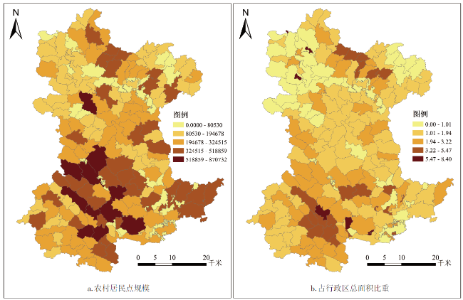
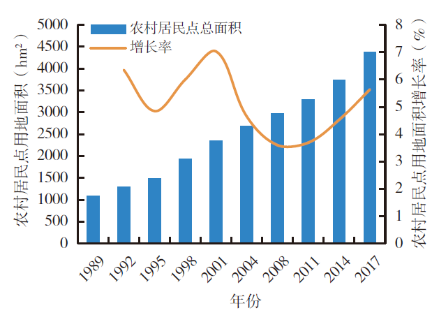
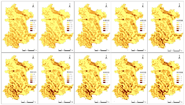
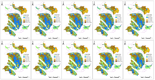
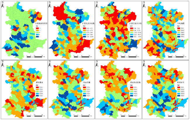
Taking administrative villages as the basic research unit,this research utilizes the scale characteristics index,kernel density analysis and landscape index to study the spatio-temporal evolution of rural settlements and rocky desertification in Pingguo county from 1989 to 2017,and explores internal driving mechanism and interaction of rural settlements and rocky desertification evolution with Geodetector. The results show that: 1) The spatial pattern of rural settlements in Pingguo county is affected by roads and rivers,and has uneven spatial distribution which presents the northeast and the southwest Pingguo county are higher than the middle,the south and the north are both higher than the middle. In term of landscape index,the north is lower than the south,it decreases from the southwest to the northwest. 2) The order of the degree of rocky desertification in Pingguo county is intensity,potential,moderate,extreme intensity,mild. Worse areas of rocky desertification mainly distribute in the northeast and the southwest county's settlements. From 1989 to 2017,the area of rocky desertification shows an increase-decrease-increase-decrease trend. 3) The evolution rate,coefficient of variation and landscape shape index of rural settlements have strong explanatory power and certain synergy in the evolution of rocky desertification. It plays an important role in the evolution of rocky desertification. The driving factor interaction of any two rural settlements has a greater impact on the spatial difference of rocky desertification than a single driving factor,and the types of interactions are both double-factor enhancement or nonlinear enhancement.
LI Xiaoqing , XU Xiuqiao , XIE Binggeng , LIU Ru , ZHOU Kaichun . Influence of Rural Residential Areas on the Evolution of Rocky Desertification in Karst Area[J]. Economic geography, 2020 , 40(10) : 154 -163 . DOI: 10.15957/j.cnki.jjdl.2020.10.018
表1 石漠化强度等级划分标准Tab.1 Classification standard of rocky desertification |
| 等级 | 基岩 裸露率 | 植被+ 土被指数 | 坡度(°) | 裸岩 分布特征 | 影像特征 |
|---|---|---|---|---|---|
| 无石漠化 | <0.2 | >0.75 | <8 | 点状 | 深红、暗红 |
| 潜在石漠化 | 0.2~0.3 | 0.5~0.75 | >8 | 点、线状 | 浅红 |
| 轻度石漠化 | 0.3~0.5 | 0.3~0.5 | >15 | 线状 | 淡红 |
| 中度石漠化 | 0.5~0.7 | 0.15~0.3 | >15 | 线、面状 | 红中带白 |
| 强度石漠化 | 0.7~0.9 | 0.05~0.15 | >25 | 面状 | 灰白 |
| 极强度石漠化 | >0.95 | <0.05 | >35 | 面状 | 白色、灰白 |
表2 不同组合下影响因素对石漠化变异系数的交互作用Tab.2 Interaction of factors affecting variation coefficient of rock desertification under different combinations |
| X1 | X2 | X3 | X4 | X5 | |
|---|---|---|---|---|---|
| X1 | 0.506019 | ||||
| X2 | 0.590644 | 0.002368 | |||
| X3 | 0.689554* | 0.423718 | 0.359867 | ||
| X4 | 0.693247* | 0.532036 | 0.637180* | 0.397322 | |
| X5 | 0.720473* | 0.524076 | 0.699271* | 0.732664* | 0.441524 |
表3 不同组合下影响因素对石漠化综合分值的交互作用Tab.3 Interaction of influencing factors on comprehensive score of rock desertification under different combinations |
| X1 | X2 | X3 | X4 | X5 | |
|---|---|---|---|---|---|
| X1 | 0.120026 | ||||
| X2 | 0.246241 | 0.104101 | |||
| X3 | 0.470369* | 0.500138* | 0.412068 | ||
| X4 | 0.757853* | 0.760424* | 0.847551* | 0.677076 | |
| X5 | 0.541139 | 0.472885* | 0.666333* | 0.786103* | 0.398188 |
注:*表示两个变量存在双因子增强作用。 |
表4 不同因素对石漠化演变类型影响的统计差异Tab.4 Differences of different factors affecting rocky desertification evolution |
| X1 | X2 | X3 | X4 | X5 | |
|---|---|---|---|---|---|
| X1 | |||||
| X2 | N | ||||
| X3 | Y | Y | |||
| X4 | N | Y | Y | ||
| X5 | Y | Y | Y | Y |
表5 不同因素对石漠化变异系数影响的统计差异Tab.5 Differences of different factors affecting variation coefficient of rocky desertification |
| X1 | X2 | X3 | X4 | X5 | |
|---|---|---|---|---|---|
| X1 | |||||
| X2 | Y | ||||
| X3 | Y | Y | |||
| X4 | Y | Y | N | ||
| X5 | N | Y | N | N |
表6 不同因素对石漠化综合分值影响的统计差异Tab.6 Differences of different influence factors on comprehensive score of rock desertification |
| X1 | X2 | X3 | X4 | X5 | |
|---|---|---|---|---|---|
| X1 | |||||
| X2 | N | ||||
| X3 | Y | Y | |||
| X4 | Y | Y | Y | ||
| X5 | Y | Y | N | Y |
| [1] |
王社教. 论历史乡村地理学研究[J]. 陕西师范大学学报:哲学社会科学版, 2006(4):73-79.
|
| [2] |
杨勇, 邓祥征, 吴锋, 等. 华北平原农村居民点演变及社会经济影响因素分析[J]. 人文地理, 2019, 34(2):116-124.
|
| [3] |
张善余. 人口地理学概论[M]. 上海: 华东师范大学出版社, 2013.
|
| [4] |
姜磊, 雷国平, 张健, 等. 农村居民点空间布局及优化分析[J]. 水土保持研究, 2013(1):224-229.
|
| [5] |
|
| [6] |
金其铭. 农村聚落地理研究——以江苏省为例[J]. 地理研究, 1982, 1(3):11-20.
|
| [7] |
|
| [8] |
|
| [9] |
|
| [10] |
|
| [11] |
|
| [12] |
|
| [13] |
|
| [14] |
李红波, 张小林, 吴江国, 等. 欠发达地区聚落景观空间分布特征及其影响因子分析——以安徽省宿州地区为例[J]. 地理科学, 2012(6):711-716.
|
| [15] |
师满江, 颉耀文, 曹琦. 干旱区绿洲农村居民点景观格局演变及机制分析[J]. 地理研究, 2016, 35(4):692-702.
|
| [16] |
朱东国, 谢炳庚, 熊鹏. 基于三维景观格局指数的张家界市土地利用格局时空演化[J]. 经济地理, 2017, 37(8):168-175.
|
| [17] |
|
| [18] |
|
| [19] |
刘彦随, 刘玉, 翟荣新. 中国农村空心化的地理学研究与整治实践[J]. 地理学报, 2009, 64(10):1193-1 202.
|
| [20] |
|
| [21] |
姜广辉, 何新, 马雯秋, 等. 基于空间自相关的农村居民点空间格局演变及其分区[J]. 农业工程学报, 2015, 31(13):265-273.
|
| [22] |
刘继来, 刘彦随, 李裕瑞, 等. 2007—2015年中国农村居民点用地与农村人口时空耦合关系[J]. 自然资源学报, 2018, 33(11):1861-1 871.
|
| [23] |
李云强, 齐伟, 王丹, 等. GIS支持下山区县域农村居民点分布特征研究[J]. 地理与地理信息科学, 2011, 27(3):73-77.
|
| [24] |
沈陈华. 丹阳市农村居民点空间分布尺度特征及影响因素分析[J]. 农业工程学报, 2012, 28(22):261-268.
|
| [25] |
钟紫玲, 王占岐, 李伟松. 基于Voronoi图与景观指数法的山区农村居民点空间分布特征及其影响因素[J]. 水土保持研究, 2014, 21(2):211-215.
|
| [26] |
姜广辉, 张凤荣, 陈军伟, 等. 基于Logistic回归模型的北京山区农村居民点变化的驱动力分析[J]. 农业工程学报, 2007, 23(5):81-87.
|
| [27] |
蓝安军, 熊康宁, 安裕伦. 喀斯特石漠化的驱动因子分析[J]. 水土保持通报, 2001, 21(6):19-23.
|
| [28] |
|
| [29] |
陈文波, 肖笃宁, 李秀珍. 景观指数分类、应用及构建研究[J]. 应用生态学报, 2002(1):121-125.
|
| [30] |
王劲峰, 徐成东. 地理探测器:原理与展望[J]. 地理学报, 2017, 72(1):116-134
|
| [31] |
白晓永, 王世杰, 陈起伟, 等. 贵州土地石漠化类型时空演变过程及其评价[J]. 地理学报, 2009, 64(5):609-618.
|
| [32] |
熊康宁. 喀斯特石漠化的遥感——GIS典型研究/以贵州省为例[M]. 北京: 地质出版社, 2002.
|
/
| 〈 |
|
〉 |