
Research on the Vegetation Index Dynamic Changes and the Impact of Urban Expansion on It for Changsha-Zhuzhou-Xiangtan Urban Agglomeration
Received date: 2019-03-22
Revised date: 2019-09-07
Online published: 2025-04-18
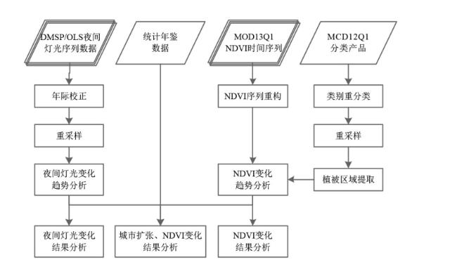
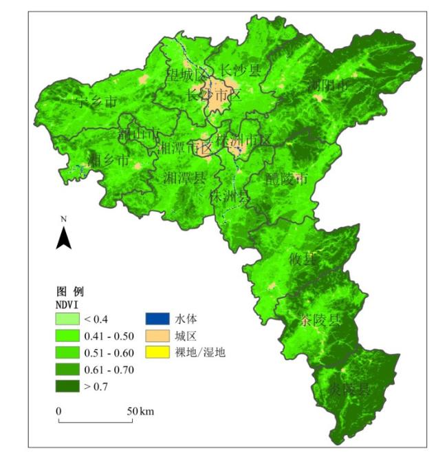
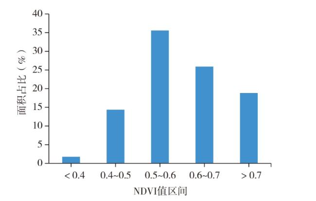
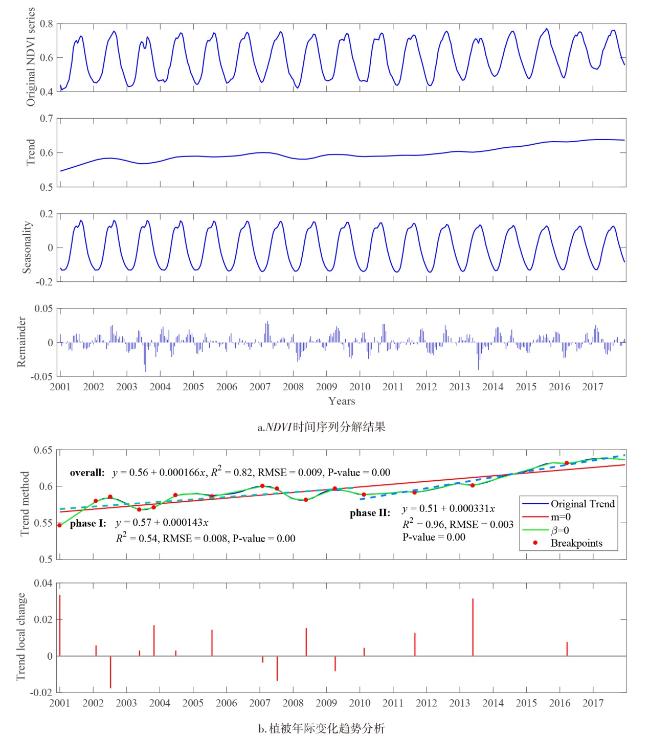
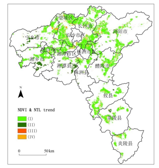
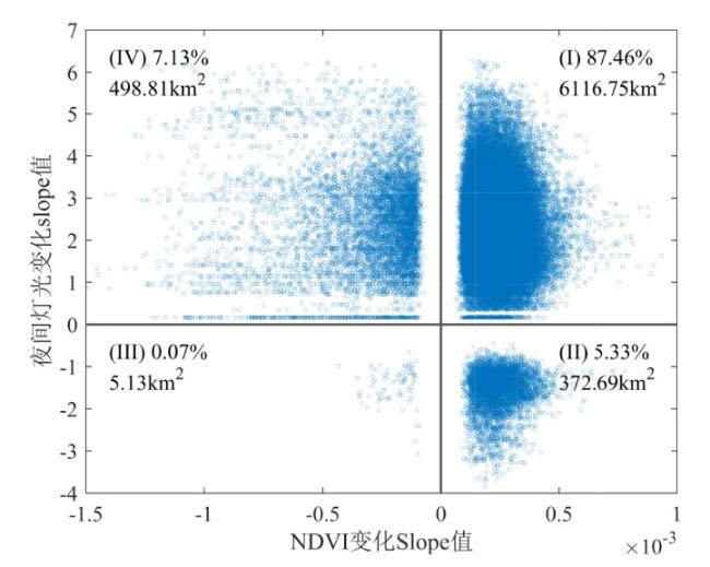
Rapid urbanization process has changed the land cover significantly, and it also altered the vegetation original growth environment. In this study, the Moderate Resolution Imaging Spectroradiometer (MODIS) vegetation products, the Defense Meteorological Satellite Program-Operational Linescan System (MDSP-OLS) urban night light time series data and some other datasets were utilized to analyze the spatiotemporal characteristics of vegetation growth dynamics, the impact of urban expansion process on vegetation dynamic changes in Changsha-Zhuzhou-Xiangtang (CZT) urban agglomeration. The results show that the vegetation coverage in the study area is good between 2001 and 2017, with the multi annual average Normalized Difference Vegetation Index (NDVI) between 0.4 and 0.6, and in general, the vegetation growth is tending well situation; the NDVI changes in the study area showed a very slowly upward trend with two distinct stages: fluctuating upward trend in 2001-2009 and significant linear upward trend in 2010-2017; due to the urban expansion, the NDVI changes, on the surrounding areas of Changsha, Zhuzhou and Xiangtang cities, showed a significant downward trend, but with a very slowly speed; the trend of MDSP-OLS series data can effectively indicate the urban expansion process of CZT urban agglomeration; during the expansion process of CZT urban agglomeration, the urban greening and ecological environment have been protected and developed carefully and well, with vegetation in 87.46% of urban expansion area maintained a significant upward trend at a very low level and only 7.13% of urban expansion area showed a significant downward trend.
HU Shunshi , PENG Yulong , QIN Jianxin , TANG Zifang . Research on the Vegetation Index Dynamic Changes and the Impact of Urban Expansion on It for Changsha-Zhuzhou-Xiangtan Urban Agglomeration[J]. Economic geography, 2019 , 39(12) : 178 -186 . DOI: 10.15957/j.cnki.jjdl.2019.12.020
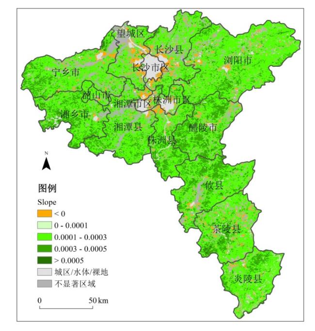
表1 NDVI显著变化区域slope值统计Tab.1 NDVI trend slope statistics with significant changes areas |
| Slope值 | 面积占比(%) | Slope值 | 面积占比(%) |
|---|---|---|---|
| <-0.0004 | 1.20 | 0.0002~0.0003 | 34.19 |
| -0.0004~0 | 2.97 | 0.0003~0.0004 | 15.10 |
| 0~0.0001 | 1.21 | 0.0004~0.0005 | 2.20 |
| 0.0001~0.0002 | 23.80 | >0.0005 | 0.32 |
| [1] |
周国华, 陈炉, 唐承丽, 等. 长株潭城市群研究进展与展望[J]. 经济地理, 2018, 38(6):52-61.
|
| [2] |
吴昊, 王维, 王文杰, 等. 长株潭地区景观格局及其变化特征研究[J]. 地球信息科学学报, 2010, 12(1):133-142.
|
| [3] |
李涛, 杨知建, 甘德欣, 等. 长株潭城市群土地利用/覆被变化对碳效应的影响[J]. 生态与农村环境学报, 2016, 32(4):539-545.
|
| [4] |
廖柳文, 秦建新. 环长株潭城市群湿地生态安全研究[J]. 地球信息科学学报, 2016, 18(9):1 217-1 226.
|
| [5] |
楚芳芳, 蒋涤非. 基于能值改进生态足迹的长株潭城市群可持续发展研究[J]. 长江流域资源与环境, 2012, 21(2):145-150.
|
| [6] |
许联芳, 谭勇. 长株潭城市群“两型社会”试验区土地承载力评价[J]. 经济地理, 2009, 29(1):69-73.
|
| [7] |
刘庆, 陈利根, 舒帮荣, 等. 长株潭城市群土地生态安全动态评价研究[J]. 长江流域资源与环境, 2010, 19(10):1 192-1 197.
|
| [8] |
顾朝林, 马婷, 袁晓辉, 等. 长株潭城市群绿心生态保护与发展探讨[J]. 长江流域资源与环境, 2010, 19(10):1 124-1 131.
|
| [9] |
赵运林, 黄田, 李黎武, 等. 基于GIS空间分析的生态服务功能重要性评价——以长株潭城市群生态绿心地区为例[J]. 城市发展研究, 2010, 17(11):125-128.
|
| [10] |
吕贤军, 赵运林. 长株潭城市群绿心地区规划管理模式探析[J]. 城市发展研究, 2014, 21(6):28-32.
|
| [11] |
|
| [12] |
|
| [13] |
方利, 王文杰, 蒋卫国, 等. 2000Jamal年黑龙江流域(中国)植被覆盖时空变化及其对气候变化的响应[J]. 地理科学, 2017, 37(11):1 745-1 754.
|
| [14] |
袁丽华, 蒋卫国, 申文明, 等. 2000—2010年黄河流域植被覆盖的时空变化[J]. 生态学报, 2013, 33(24):7 798-7 806.
|
| [15] |
郝蕊芳, 于德永, 刘宇鹏, 等. DMSP/OLS灯光数据在城市化监测中的应用[J]. 北京师范大学学报:自然科学版, 2014, 50(4):407-413.
|
| [16] |
李德仁, 余涵若, 李熙. 基于夜光遥感影像的“一带一路”沿线国家城市发展时空格局分析[J]. 武汉大学学报:信息科学版, 2017, 42(6):711-720.
|
| [17] |
易凤佳, 李仁东, 常变蓉. 基于面向对象的长株潭地区遥感影像分类方法[J]. 华中师范大学学报:自然科学版, 2014, 48(6):910-916.
|
| [18] |
|
| [19] |
|
| [20] |
|
| [21] |
|
| [22] |
胡顺石, 张辰璐, 彭雨龙, 等. 湖南省不同云状态的时空特征分析[J]. 地球信息科学学报, 2019, 21(5):688-698.
|
| [23] |
胡顺石, 黄春晓, 杨斌, 等. 自适应加权Savitzky-Golay滤波重构MODIS植被指数时间序列[J/OL]. 测绘科学, http://kns.cnki.net/kcms/detail/11.4415.P.20191205.1656.020.html.
|
| [24] |
|
| [25] |
|
| [26] |
吴健生, 李双, 张曦文. 中国DMSP-OLS长时间序列夜间灯光遥感数据饱和校正研究[J]. 遥感学报, 2018, 22(4):621-632.
|
| [27] |
蒋友严, 杜文涛, 黄进, 等. 2000—2015年祁连山植被变化分析[J]. 冰川冻土, 2017, 39(5):1 130-1 136.
|
| [28] |
|
| [29] |
张剑明, 居晶琳, 黎祖贤, 等. 湖南省农业旱灾的年际变化及重灾年份预测[J]. 自然灾害学报, 2011, 20(5):105-110.
|
/
| 〈 |
|
〉 |