
The Measurement of Urban Concentration in China and the Study of Its Spatial Differentiation Characteristics: Based on DMSP-OLS Nighttime Light Data
Received date: 2020-03-16
Revised date: 2021-03-27
Online published: 2025-04-17
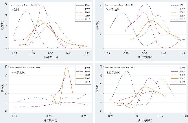
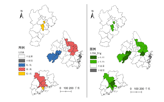
The paper takes urban concentration as the main thrust of study, develops an index measuring urban concentration based on nighttime light data from 1992 to 2013, and then investigates the spatial differentiation characteristics of urban concentration in varied regional scopes using kernel density analysis and exploratory spatial data analysis method. The main results are obtained as follows: 1) The urban system of China is trending towards flattening in general. Specifically, the degree of urban concentration experienced an unsteady growth during 1992-2003, witnessed a fluctuant decline and significant diversity among different regions after 2000. In the respect of three major regions, the east develops in the similar way of national tendency, inner regions of the midland began to develop into different directions in the late 21st century, and the degree of urban concentration in the west is constantly increasing until now. In the respect of typical urban agglomerations, the cities of Beijing-Tianjin-Hebei Urban Agglomeration vary remarkably in population size. Metropolitan stretches have been formed in the east part of Yangtze river delta, whereas the cities located in the west part, which are within the boundaries of Anhui Province, formed a low-low cluster, which means there exists an intercity gap in the agglomeration. In comparison, the core cities of Pearl river delta are closely related with surrounding areas, the gross volume of nighttime light intensity is relatively high in general, which brings about extensive diffusion effect.
SHEN Jie . The Measurement of Urban Concentration in China and the Study of Its Spatial Differentiation Characteristics: Based on DMSP-OLS Nighttime Light Data[J]. Economic geography, 2021 , 41(5) : 46 -56 . DOI: 10.15957/j.cnki.jjdl.2021.05.006
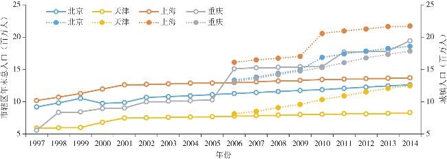
图1 户籍非农人口与常住城镇人口的差异(1997—2014年)注:1.图中实线代表非农人口,虚线代表城镇人口;非农人口为户籍人口口径,城镇人口为常住人口口径。2.非农人口数据来源于《中国城市统计年鉴》(1998—2009),2009年及以后年份的非农人口数据缺失;城镇人口数来源于《中国统计年鉴》(2006—2015)分地区人口城乡构成。 Fig.1 The difference between household registered non-agricultural population and resident urban population in 1997-2014 |
表1 全国灯光亮度与人口规模、城市建设的相关性检验(1995—2013年)Tab.1 The correlation test of national light intensity, population size and urban construction in 1995-2013 |
| 年末总人口 (万人) | 城镇人口 (万人) | 建成区面积 (km2) | 城市建设用 地面积(km2) | |
|---|---|---|---|---|
| 灯光灰度值 | 0.895*** | 0.932*** | 0.958*** | 0.952*** |
| 灯光亮度表面积 | 0.924*** | 0.936*** | 0.930*** | 0.922*** |
| 灯光亮度体积 | 0.899*** | 0.935*** | 0.960*** | 0.956*** |
注:1. 数据来源于1996—2014年《中国统计年鉴》;2. *、**、***分别代表在10%、5%、1%的显著性水平下显著。表2同。 |
表2 面板数据相关性检验结果(1992—2013年)Tab.2 The correlation test based on panel data in 1992-2013 |
| 区域 | 常住人口 (万人) | 城镇人口 (万人) | 非农人口 (万人) | 建成区 面积(km2) | 城市建设用 地面积(km2) |
|---|---|---|---|---|---|
| 全样本 | 0.497*** | 0.534*** | 0.584*** | 0.527*** | 0.066 |
| 东部 | 0.681*** | 0.685*** | 0.792*** | 0.736*** | 0.030 |
| 中部 | 0.455*** | 0.572*** | 0.420*** | 0.393*** | 0.445*** |
| 西部 | 0.433*** | 0.510*** | 0.622*** | 0.581*** | 0.587*** |
| [1] |
|
| [2] |
|
| [3] |
|
| [4] |
周文. 城市集中度对经济发展的影响研究[M]. 北京: 中国人民大学出版社, 2016.
|
| [5] |
|
| [6] |
|
| [7] |
|
| [8] |
马卫, 白永平, 张雍华, 等. 2002—2011年中国新型城市化空间格局与收敛性分析[J]. 经济地理, 2015, 35(2):62-70.
|
| [9] |
徐伟平, 夏思维. 我国城镇化水平收敛性——理论假说与实证研究[J]. 人口与经济, 2016(1):1-9.
|
| [10] |
江曼琦, 王振坡, 王丽艳. 中国城市规模分布演进的实证研究及对城市发展方针的反思[J]. 上海经济研究, 2006(6):29-35.
|
| [11] |
肖文, 王平. 外部规模经济、拥挤效应与城市发展:一个新经济地理学城市模型[J]. 浙江大学学报:人文社会科学版, 2011, 41(2):94-105.
|
| [12] |
孙浦阳, 武力超, 张伯伟. 空间集聚是否总能促进经济增长:不同假定条件下的思考[J]. 世界经济, 2011(10):3-20.
|
| [13] |
蔡寅寅, 孙斌栋. 城市人口空间分散与经济增长——基于特大城市的实证分析[J]. 城市观察, 2013, 27(5):94-101.
|
| [14] |
李佳洺, 张文忠, 孙铁山, 等. 中国城市群集聚特征与经济绩效[J]. 地理学报, 2014, 69(4):474-484.
|
| [15] |
陆铭, 向宽虎, 陈钊. 中国的城市化和城市体系调整:基于文献的评论[J]. 世界经济, 2011(6):3-25.
|
| [16] |
安虎森. 新经济地理学原理[M]. 北京: 经济科学出版社, 2009.
|
| [17] |
童玉芬, 马艳林. 城市人口空间分布格局影响因素研究——以北京为例[J]. 北京社会科学, 2016(1):89-97.
|
| [18] |
王垚, 王春华, 洪俊杰, 等. 自然条件、行政等级与中国城市发展[J]. 管理世界, 2015(1):41-50.
|
| [19] |
|
| [20] |
|
| [21] |
|
| [22] |
|
| [23] |
|
| [24] |
|
| [25] |
程砾瑜. 基于DMSP/OLS夜间灯光数据的中国人口分布时空变化研究[D]. 北京: 中国科学院遥感应用研究所, 2008.
|
| [26] |
王慧娟, 兰宗敏, 金浩, 等. 基于夜间灯光数据的长江中游城市群城镇体系空间演化研究[J]. 经济问题探索, 2017(3):107-114.
|
| [27] |
姚永玲. 北京郊区化进程中的“超非均衡”空间结构[J]. 经济地理, 2011, 31(9):1458-1462.
|
| [28] |
陈斐, 杜道生. 空间统计分析与GIS在区域经济分析中的应用[J]. 武汉大学学报:信息科学版, 2002, 27(4):391-396.
|
| [29] |
陈彦光. 基于Moran统计量的空间自相关理论发展和方法改进[J]. 地理研究, 2009, 28(6):1449-1463.
|
| [30] |
张可云, 王裕瑾, 王婧. 空间权重矩阵的设定方法研究[J]. 区域经济评论, 2017 (1):19-25.
|
/
| 〈 |
|
〉 |
