
Optimization Path and Practice of Spatial Pattern of Regional Urbanization: Taking Jilin Province as an Example
Received date: 2019-11-25
Revised date: 2020-04-21
Online published: 2025-04-17
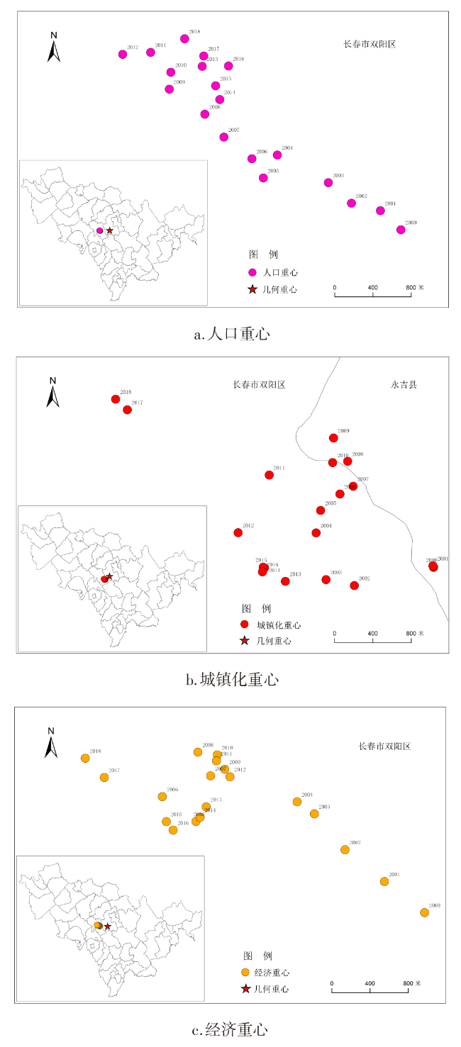
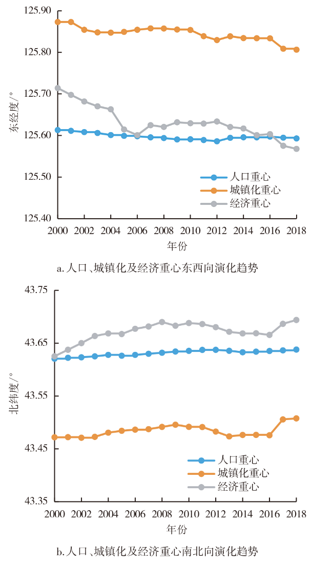
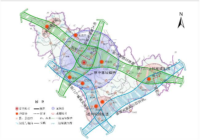
Taking Jilin Province as the study area,using gravity analysis model and geo statistical method,based on analyzing the characteristics and problems of spatio temporal spatial pattern of urbanization evolution,the scenario analysis method is applied to optimize the spatial pattern of urbanization for the first time,and the optimization of spatial pattern of regional urbanization is studied from two dimensions of theory and practice. Results show: To "optimize the spatial pattern of regional urbanization" as the core goal,the scenario analysis method as the foundation,constructing the "Temporal and spatial evolution characteristics→Summary of existing problems→Scenario optimization simulation→Strategic choice of development" regional urbanization spatial pattern optimization logic path,and successfully applied to the urban space pattern optimization practice in Jinlin province. Through the scene construction,analysis and evaluation,finally put forward the" Strengthening the central region,developing the group,constructing the pivot and the regional linkage" of the spatial development strategy and regional urbanization development direction of Jilin Province,constructing of "a group of three groups and four axis" of urbanization spatial development pattern,the main body of urbanization development is supported by the central city group as the core and the urban agglomeration of the Tumen River region,the white town group and the Baicheng town group in the west,Regional linkage development pattern with the linking development axis between Harbin and Dalian,linking development axis between Tumen and Ulanhot development axis,Eastern border axis of Jilin Province and The southern gateway of Jilin Province.
YANG Qingshan , JIANG Xiaojun , LIU Jian . Optimization Path and Practice of Spatial Pattern of Regional Urbanization: Taking Jilin Province as an Example[J]. Economic geography, 2020 , 40(5) : 10 -18 . DOI: 10.15957/j.cnki.jjdl.2020.05.002
表1 四大轴线相关指标对比Tab.1 Comparison of related indexes of four major axes |
| 轴线/时间/指标 | 年份 | 总人口(万人) | 占比(%) | 非农人口(万人) | 占比(%) | GDP(亿元) | 占比(%) |
|---|---|---|---|---|---|---|---|
| 哈大轴 | 2000 | 494.02 | 18.58 | 281.34 | 23.48 | 803.83 | 26.03 |
| 2018 | 660.46 | 24.95 | 386.23 | 30.25 | 7 059.09 | 44.90 | |
| 图乌轴 | 2000 | 802.45 | 30.19 | 472.03 | 39.40 | 1 198.41 | 38.81 |
| 2018 | 1 031.47 | 38.97 | 649.10 | 50.84 | 8 936.15 | 56.84 | |
| 东部沿边轴 | 2000 | 285.23 | 10.73 | 160.77 | 13.42 | 236.70 | 7.67 |
| 2018 | 386.32 | 14.59 | 211.63 | 16.58 | 1 527.44 | 9.72 | |
| 南部门户轴 | 2000 | 250.83 | 9.44 | 163.28 | 13.63 | 226.58 | 7.34 |
| 2018 | 332.14 | 12.55 | 249.28 | 19.52 | 1 389.97 | 8.84 |
表2 最有可能出现的不确定性因素组合Tab.2 The most likely combination of uncertainty factors |
| 因素/情景 | 一群三团四轴 | 二群二团二轴 | 五团二轴 |
|---|---|---|---|
| 区域发展规划实施 | +++ | ++ | + |
| 交通基础设施建设 | +++ | ++ | + |
| 城镇建设资金投入 | +++ | ++ | + |
| 生态环境时空变化 | +++ | ++ | + |
| 对外开放水平提升 | +++ | ++ | + |
注:“+++”表示各因素量和变化大;“++”表示各因素量和变化适中;“+”表示各因素量和变化有限。 |
表3 城镇化发展格局战略选择评价指标体系Tab.3 The evaluation index system for strategic choice of development pattern |
| 一级指标 | 二级指标 |
|---|---|
| 空间结构(0.3) | 规划连续性(0.2):不同层次规划实施连续性及高效性 |
| 布局合理性(0.2):不同等级城市空间布局合理性 | |
| 产业协调性(0.3):不同产业在空间布局上的协调度 | |
| 城镇联系度(0.15):不同职能城镇交流合作的效率 | |
| 人居便捷性(0.15):城乡居民居住与就业的便捷度 | |
| 交通体系(0.25) | 交通通达性(0.35):区域之间交通联系的可达度 |
| 交通平衡性(0.2):综合交通网络间的平衡度 | |
| 交通一体性(0.15):多种交通方式运行的协调度 | |
| 设施有效性(0.3):交通枢纽及基础建设的利用度 | |
| 资金保障(0.15) | 资金结构性(0.2):资金来源结构的合理性 |
| 资金充裕性(0.25):资金保障城镇建设的充足性 | |
| 资金持续性(0.25):资金供应的可持续性 | |
| 资金兼顾性(0.3):不同领域建设资金分配合理度 | |
| 生态环境(0.15) | 基底优质性(0.3):不同区域生态环境基础 |
| 用地集约性(0.2):土地利用的集约程度 | |
| 城市生态性(0.2):人文与自然环境协调发展程度 | |
| 生活舒适性(0.3):城乡居民对生态环境的满意度 | |
| 开放水平(0.15) | 政治稳定性(0.3):国内外政治的稳定性 |
| 政策延续性(0.2):国内开放政策的持续性 | |
| 平台有效性(0.25):开放平台发挥作用的有效性 | |
| 区域参与性(0.25):不同等级城市参与交流合作程度 |
表4 吉林省城镇化发展格局情景模糊综合评价结果Tab.4 The results of fuzzy comprehensive evaluation of development pattern in Jilin Province |
| 发展情景 | 空间 结构 | 交通 体系 | 资金 保障 | 生态 环境 | 开放 水平 | 综合值 |
|---|---|---|---|---|---|---|
| 一群二团四轴 | 0.85 | 0.74 | 0.31 | 0.51 | 0.68 | 0.665 |
| 二群二团二轴 | 0.51 | 0.39 | 0.48 | 0.62 | 0.21 | 0.447 |
| 五团二轴 | 0.32 | 0.18 | 0.59 | 0.71 | 0.62 | 0.429 |
| [1] |
方创琳. 中国城市发展格局优化的科学基础与框架体系[J]. 经济地理, 2013, 33(12):1-9.
|
| [2] |
毕鹏波. 山东省城市化空间结构优化研究[D]. 济南: 山东财经大学, 2012.
|
| [3] |
李文翎, 刘洪杰. 城镇化空间发展研究[J]. 小城镇建设, 2008(7):84-87.
|
| [4] |
|
| [5] |
王怡睿, 黄煌, 石培基. 中国城镇化质量时空演变研究[J]. 经济地理, 2017, 37(1):90-97.
|
| [6] |
王雪芹, 戚伟, 刘盛和. 中国小城镇空间分布特征及其相关因素[J]. 地理研究, 2020, 39(2):319-336.
|
| [7] |
欧阳晓, 朱翔. 中国城市群城市用地扩张时空动态特征[J]. 地理学报, 2020, 75(3):571-588.
|
| [8] |
刘欢, 邓宏兵, 谢伟伟. 长江经济带市域人口城镇化的时空特征及影响因素[J]. 经济地理, 2017, 37(3):55-62
|
| [9] |
苏凯, 魏道智, 林文雄. 福建省城镇化效率的区域差异及空间格局研究[J]. 生态学报, 2019, 39(15):5450-5 459.
|
| [10] |
凌筱舒, 王立, 薛德升. 江西省县域城镇化水平测度及其分异研究[J]. 人文地理, 2014, 29(3):89-94.
|
| [11] |
初楠臣, 姜博, 赵映慧, 等. 城际高铁对未来黑龙江城镇体系空间格局的影响及优化[J]. 经济地理, 2016, 36(4):78-83.
|
| [12] |
高汝熹. 城市圈域经济论[M]. 昆明: 云南大学出版社,1998.
|
| [13] |
常青, 王仰麟, 李双成. 中小城镇绿色空间评价与格局优化——以山东省即墨市为例[J]. 生态学报, 2007, 27(9):3701-3 710.
|
| [14] |
方创琳. 中国城市发展空间格局优化的总体目标与战略重点[J]. 城市发展研究, 2016, 23(10):1-9.
|
| [15] |
刘永, 郭怀成, 王丽婧, 等. 环境规划中情景分析方法及应用研究[J]. 环境科学研究, 2005, 18(3):82-87.
|
| [16] |
卢毅, 李理, 赵勇, 等. 基于情景分析的城市空间与产业战略布局选择——以宜宾市为例[J]. 经济地理, 2013, 33(3):93-98.
|
| [17] |
罗绍荣, 甄峰, 魏宗财. 城市发展战略规划中情景分析方法的运用——以临汾市为例[J]. 城市问题, 2008(9):29-34.
|
| [18] |
熊建华, 唐将伟. 基于情景分析法的城市土地生态安全预警研究——以深圳为例[J]. 安全与环境学报, 2018, 18(3):1215-1 219.
|
| [19] |
付加锋, 刘小敏. 基于情景分析法的中国低碳经济研究框架与问题探索[J]. 资源科学, 2010, 32(2):205-210.
|
| [20] |
王知津, 周鹏, 韩正彪. 基于情景分析法的企业危机发展预测[J]. 图书馆论坛, 2010, 30(6):299-302.
|
| [21] |
王知津, 周鹏, 韩正彪. 基于情景分析法的技术预测研究[J]. 图书情报知识, 2013(5):115-122.
|
| [22] |
|
/
| 〈 |
|
〉 |