
Delimitation of the Growth Boundary of Oasis Towns Based on Habitat Quality: A Case Study of the Middle Reaches of Heihe River
Received date: 2019-05-15
Revised date: 2019-12-11
Online published: 2025-04-11
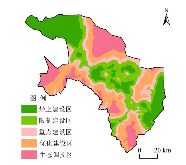
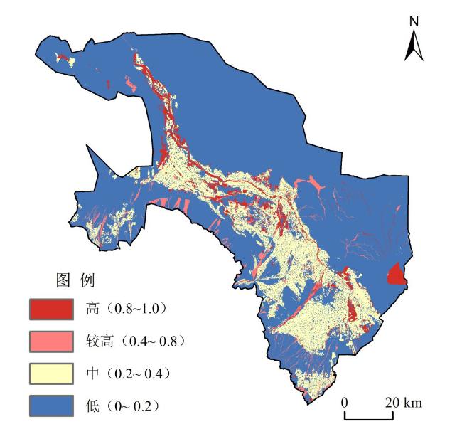
Oasis towns are the areas where human activities are the most concentrated and the relationship between man and land is the most sensitive,and it is also the area where the contradiction of "Production,Living and Ecological Space" is the most serious. The delimitation of urban growth boundary is a technical means and policy tool to control the disorderly spread of cities and guide the orderly development of urban space. and it is an important part of the national and local spatial governance system. This paper takes oasis towns in the middle reaches of Heihe River as the research object,and puts forward a method for delineating the growth boundary of oasis towns based on habitat quality: Firstly,the quality of oasis habitat is evaluated based on InVEST model;Secondly,the evaluation results of oasis ecological suitability are embedded in SLEUTH model to simulate urban growth boundary;Finally,take the urban construction land area assigned by the overall planning for land use as the control scale,the simulated boundary is revised by using the results of habitat quality assessment,and the urban growth boundary is finally delineated. The results show that: The total area within the urban growth boundary is 104.67 km2,and the remaining constructable land area is 22.14 km2,which is dominated by low-grade habitat quality,accounting for 66.98% of the newly added urban land within the boundary. The urban growth space in oasis plain area and piedmont alluvial sector is small, and the proportion of remaining constructable land is 9.96% and 24.57%, respectively;The urban industrial parks in the oasis fringe have some growth space,the proportion of remaining constructable land is 52.53%. The urban industrial parks in the oasis fringe have great potential for spatial growth,and the proportion of remaining constructable land is 52.53%. This method can effectively solve the contradiction between urban development and ecological environment. It has an important reference for the delimitation of urban growth boundary in oasis towns.
LI Qianguo , WANG Lucang , SHI Peiji , YAN Cuixia , LIU Haiyang . Delimitation of the Growth Boundary of Oasis Towns Based on Habitat Quality: A Case Study of the Middle Reaches of Heihe River[J]. Economic geography, 2020 , 40(3) : 92 -101 . DOI: 10.15957/j.cnki.jjdl.2020.03.011
表1 研究区不同生境类型威胁源数据表Tab.1 Threat source data table of different habitat types in the Study area |
| 威胁源 | 权重 | 敏感度 | 最大威胁距离(km) | 空间衰减类型 | |||
|---|---|---|---|---|---|---|---|
| 耕地 | 林地 | 草地 | 水域 | ||||
| 建设用地 | 1.0 | 0.50 | 0.70 | 0.65 | 0.70 | 8 | 指数 |
| 高速公路 | 0.8 | 0.30 | 0.20 | 0.35 | 0.40 | 5 | 指数 |
| 铁路 | 0.6 | 0.25 | 0.20 | 0.35 | 0.45 | 3 | 指数 |
| 国省道 | 0.5 | 0.20 | 0.25 | 0.45 | 0.55 | 4 | 指数 |
| 县乡道 | 0.3 | 0.15 | 0.20 | 0.35 | 0.30 | 3 | 线性 |
| 耕地 | 0.2 | 0.20 | 0.40 | 0.45 | 0.50 | 1 | 线性 |
表2 阻力评价体系Tab.2 Resistance evaluation system |
| 阻力因子 | 扩张类型 | 阻力等级 | 权重 | ||||
|---|---|---|---|---|---|---|---|
| 生态用地 城镇用地 | 1 | 2 | 3 | 4 | 5 | ||
| 5 | 4 | 3 | 2 | 1 | |||
| 土地利用类型 | 林地、水域 | 草地 | 耕地 | 未利用地 | 建设用地 | 0.21 | |
| 生境质量指数 | 0.8~1.0 | 0.6~0.8 | 0.4~0.6 | 0.2~0.4 | 0~0.2 | 0.18 | |
| 植被覆盖度 | 80%~100% | 60%~80% | 40%~60% | 20%~40% | 0~20% | 0.15 | |
| 距道路距离 | >1 000 m | 650~1 000 m | 300~650 m | 150~300 m | 0~150 m | 0.09 | |
| 距水域距离 | 0~50 m | 50~100 m | 100~150 m | 150~200 m | >200m | 0.07 | |
| 生态功能区 | 黑河湿地保护区、东大山自 然保护区、基本农田保护区 | - | - | - | 其他区域 | 0.11 | |
表3 SLEUTH模型校正参数设置表Tab.3 Calibration parameter settings of the SLEUTH model |
| 模型控制参数 | 粗校正 | 精校正 | 终校正 | 最佳参数获取 | 最优 增长 系数 | ||||
|---|---|---|---|---|---|---|---|---|---|
| 蒙特卡洛迭代次数=4 | 蒙特卡洛迭代次数=8 | 蒙特卡洛迭代次数=12 | 蒙特卡洛迭代次数=100 | ||||||
| OSM=0.624 | OSM=0.735 | OSM=0.812 | |||||||
| 范围 | 步长 | 范围 | 步长 | 范围 | 步长 | 范围 | 步长 | ||
| 散步系数 | 0~100 | 25 | 0~25 | 5 | 3~10 | 1 | 1~1 | 1 | 55 |
| 繁殖系数 | 0~100 | 25 | 0~75 | 10 | 15~60 | 7 | 15~15 | 1 | 47 |
| 扩展系数 | 0~100 | 25 | 35~85 | 5 | 55~90 | 3 | 55~55 | 1 | 81 |
| 坡度系数 | 0~100 | 25 | 25~70 | 5 | 30~55 | 1 | 35~35 | 1 | 5 |
| 道路引力系数 | 0~100 | 25 | 20~100 | 10 | 55~90 | 4 | 90~90 | 1 | 75 |
| [1] |
汪贝. 耦合规划空间管制的城市扩展模拟与城市开发边界划定[D]. 武汉: 武汉大学, 2018.
|
| [2] |
王婧, 方创琳. 城市建设用地增长研究进展与展望[J]. 地理科学进展, 2011, 30(11):1440-1 448.
|
| [3] |
|
| [4] |
|
| [5] |
|
| [6] |
张庭伟. 控制城市用地蔓延:一个全球的问题[J]. 城市规划, 1999(8):43-47,62.
|
| [7] |
刘海龙. 从无序蔓延到精明增长——美国“城市增长边界”概念述评[J]. 城市问题, 2005(3):67-72.
|
| [8] |
张进. 美国的城市增长管理[J]. 国外城市规划, 2002(2):37-40.
|
| [9] |
冯科, 吴次芳, 韦仕川, 等. 城市增长边界的理论探讨与应用[J]. 经济地理, 2008, 28(3):425-429.
|
| [10] |
黄慧明, Sam Casella.Faicp.PP. 美国“精明增长”的策略、案例及在中国应用的思考[J]. 现代城市研究, 2007(5):19-28.
|
| [11] |
祝仲文, 莫滨, 谢芙蓉. 基于土地生态适宜性评价的城市空间增长边界划定——以防城港市为例[J]. 规划师, 2009, 25(11):40-44.
|
| [12] |
邱思齐, 岳文泽. 刚性与弹性相结合的城市开发边界划定 ——以浙江省义乌市为例[J]. 应用生态学报, 2018, 29(5):1607-1616.
|
| [13] |
周锐, 王新军, 苏海龙, 等. 基于生态安全格局的城市增长边界划定——以平顶山新区为例[J]. 城市规划学刊, 2014(4):57-63.
|
| [14] |
钟珊, 赵小敏, 郭熙, 等. 基于空间适宜性评价和人口承载力的贵溪市中心城区城市开发边界的划定[J]. 自然资源学报, 2018, 33(5):801-812.
|
| [15] |
王振波, 张蔷, 张晓瑞, 等. 基于资源环境承载力的合肥市增长边界划定[J]. 地理研究, 2013, 32(12):2302-2 311.
|
| [16] |
龙瀛, 韩昊英, 毛其智. 利用约束性CA制定城市增长边界[J]. 地理学报, 2009, 64(8):999-1 008.
|
| [17] |
刘辉, 张志赟, 税伟, 等. 资源枯竭型城市增长边界划定研究 ——以淮北市为例[J]. 自然资源学报, 2017, 32(3):391-405.
|
| [18] |
|
| [19] |
|
| [20] |
|
| [21] |
苏伟忠, 杨桂山, 陈爽, 等. 城市增长边界分析方法研究—— 以长江三角洲常州市为例[J]. 自然资源学报, 2012, 27(2):322-331.
|
| [22] |
王录仓, 高静. 黑河流域城镇发展的历史回眸和现代检视[M]. 北京: 科学出版社, 2017.
|
| [23] |
李并成. 河西走廊汉唐古绿洲沙漠化的调查研究[J]. 地理学报, 1998(2):12-21.
|
| [24] |
|
| [25] |
刘春芳, 王川, 刘立程. 三大自然区过渡带生境质量时空差异及形成机制——以榆中县为例[J]. 地理研究, 2018, 37(2):419-432.
|
| [26] |
|
| [27] |
|
| [28] |
|
| [29] |
俞孔坚. 生物保护的景观生态安全格局[J]. 生态学报, 1999 (1):10-17.
|
| [30] |
杨振, 王晓霞, 刘会敏. 洱海流域城镇用地扩展边界划分研究[J]. 经济地理, 2015, 35(2):163-168.
|
| [31] |
赵小娜, 宫雪, 田丰昊, 等. 延龙图地区城市土地生态适宜性评价[J]. 自然资源学报, 2017, 32(5):778-787.
|
| [32] |
叶玉瑶, 苏泳娴, 张虹鸥, 等. 生态阻力面模型构建及其在城市扩展模拟中的应用[J]. 地理学报, 2014, 69(4):485-496.
|
| [33] |
|
| [34] |
|
| [35] |
何丹, 金凤君, 蔡建明. 近20年京津廊坊地区城市增长模拟和预测研究[J]. 经济地理, 2011, 31(1):7-13.
|
| [36] |
郗凤明, 胡远满, 贺红士, 等. 基于SLEUTH模型的沈阳—抚顺都市区城市规划[J]. 中国科学院研究生院学报, 2009, 26(6):765-773.
|
/
| 〈 |
|
〉 |
