
Patterns of Urban Land Expansion and Its Driving Forces in Yangtze River Delta Urban Agglomeration
Received date: 2020-08-07
Revised date: 2021-06-22
Online published: 2025-04-01
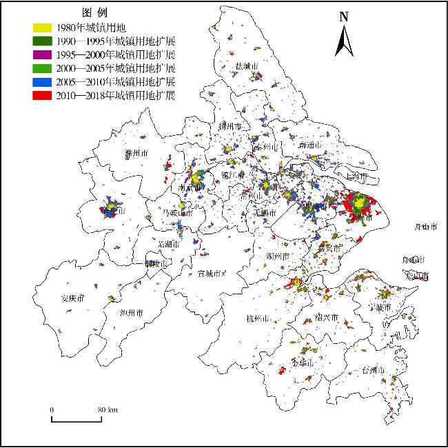
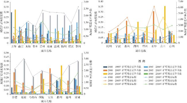
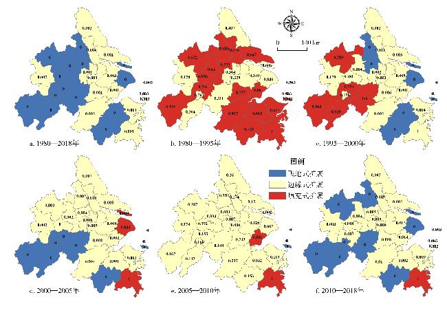
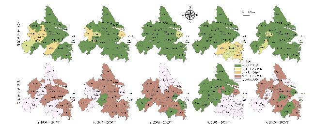
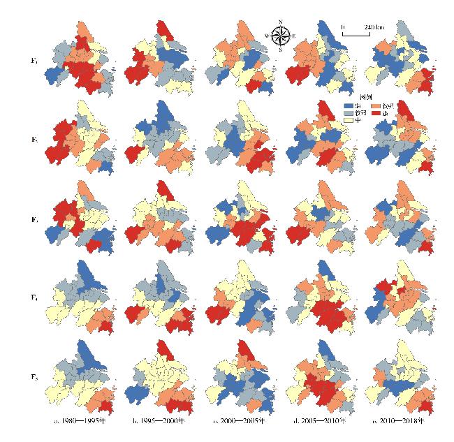
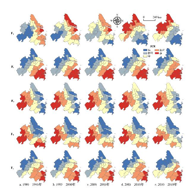
The direct spatial manifestation of urbanization and land use change is the expansion of urban land use. Based on the methods of the expansion intensity index and expansion difference index of urban land,landscape expansion index,population-land coordination degree,and economy-land coordination degree,this paper analyzes the characteristics and expansion quality of urban land in the Yangtze River Delta Urban Agglomeration from 1980 to 2018. And then using the gravity-GTWR model,it analyzes the driving factors of urban land expansion with different levels of development in different periods.The results show that: 1) From 1980 to 2018,the intensity of urban land expansion,on the whole,showed fluctuating change in the Yangtze River Delta Urban Agglomeration,which is decline,rise and decline in sequence. Higher value of expansion intensity appeared in the period of 2005-2010. Before 2005,urban land expansion with rapid development mainly concentrated in Shanghai and cities of Jiangsu,Zhejiang and so on. After 2010,the urban expansion intensity of cities in Anhui Province began to increase. 2) The speed of urban land expansion was higher in the south of the Yangtze River Delta Urban Agglomeration than in the north,and showed a tendency of northward shift. The more important driving factors were economic growth,education level and transportation location. 3) The patterns of urban land expansion in the Yangtze River Delta Urban Agglomeration were dominated by outlying expansion and edge expansion,and the spatial development mode gradually changed to the multi-core development mode,which was made up of four function cores: the center for undertaking resource in the west of urban agglomeration,the education center in the central,the science and technology research center in the south,the resource allocation center in the east.
QIAO Wenyi , HUANG Xianjin . Patterns of Urban Land Expansion and Its Driving Forces in Yangtze River Delta Urban Agglomeration[J]. Economic geography, 2021 , 41(9) : 162 -173 . DOI: 10.15957/j.cnki.jjdl.2021.09.017
表1 驱动因子Tab.1 Driving factors of urban land expansion |
| 指标名称 | 变量 | 单位 | 指标名称 | 变量 | 单位 |
|---|---|---|---|---|---|
| 常住人口 | X1 | 万人 | 工业总产值 | X8 | 亿元 |
| 第二、三产业从业人员 | X2 | 万人 | 农业总产值 | X9 | 亿元 |
| GDP | X3 | 亿元 | 货运量 | X10 | 万t |
| 二、三产业产值比重 | X4 | 亿元 | 客运量 | X11 | 万人 |
| 社会消费品零售总额 | X5 | 亿元 | 高等学生 | X12 | 万人 |
| 固定资产投资 | X6 | 亿元 | 卫生技术人员 | X13 | 万人 |
| 财政收入 | X7 | 亿元 | 卫生机构数 | X14 | 个 |
| 财政支出 | X8 | 亿元 | 医院床位 | X16 | 万张 |
表2 主成分变量主导因子Tab.2 Dominant factors of principal components of driving factors |
| 主成分 | 主成分主要构成 | 主导方向 |
|---|---|---|
| F1 | X2、X3、X5、X6、X7、X8、X14、X16 | 经济主导 |
| F2 | X9、X11、X12、X15 | 交通主导 |
| F3 | X1、X13 | 教育主导 |
| F4 | X10 | 第一产业主导 |
| F5 | X4 | 二、三产业主导 |
表3 1980—2018年城市发展核心驱动力Tab.3 The core driving force of urban development from 1980 to 2018 |
| 指标 | 核心驱动力 | 城市范围 |
|---|---|---|
| 扩张强度 | 经济、交通、第二、三产业 | 宁波、台州、舟山、绍兴、金华 |
| 交通、教育 | 盐城、泰州、扬州、南京、常州、苏州 | |
| 扩张强度差异 | 交通、第二、三产业 | 上海、嘉兴、杭州、金华、绍兴、宁波、舟山 |
| 经济 | 江苏各地市 | |
| 景观扩展指数 | 教育 | 南京、苏州、常州、无锡 |
| 交通、第二、三产业 | 上海、嘉兴、杭州、金华、绍兴、宁波、舟山 | |
| 社会经济 | 杭州、金华、马鞍山 | |
| 人口流动、教育 | 上海市、浙江省全部地市、无锡、苏州、南通 | |
| 社会经济 | 盐城、南通、绍兴、金华、台州 |
| [1] |
方创琳, 宋吉涛, 张蔷, 等. 中国城市群结构体系的组成与空间分异格局[J]. 地理学报, 2005, 65(5):827-840.
|
| [2] |
方创琳. 中国城市群研究取得的重要进展与未来发展方向[J]. 地理学报, 2014, 69(8):1130-1144.
|
| [3] |
欧阳晓, 朱翔. 中国城市群城市用地扩张时空动态特征[J]. 地理学报, 2020, 75(3):571-588.
|
| [4] |
黄金川, 林浩曦. 京津冀城市群多情景空间演化模拟[J]. 地理研究, 2017, 36(3):506-517.
|
| [5] |
车前进, 段学军, 郭垚, 等. 长江三角洲地区城镇空间扩展特征及机制[J]. 地理学报, 2011, 66(4):446-456.
|
| [6] |
魏石梅, 潘竟虎, 张永年, 等. 基于DMSP-OLS夜间灯光数据的中原城市群空间演变分析[J]. 人文地理, 2019, 34(6):71-81.
|
| [7] |
徐进勇, 张增祥, 赵晓丽, 等. 近40年珠江三角洲主要城市时空扩展特征及驱动力分析[J]. 北京大学学报:自然科学版, 2015, 51(6):1119-1131.
|
| [8] |
关兴良, 方创琳, 周敏, 等. 武汉城市群城镇用地空间扩展时空特征分析[J]. 自然资源学报, 2012, 27(9):1447-1459.
|
| [9] |
胡顺石, 彭雨龙, 秦建新, 等. 长株潭城市群植被指数动态变化及城市扩展对其影响分析[J]. 经济地理, 2019, 39(12):178-186.
|
| [10] |
方创琳. 京津冀城市群协同发展的理论基础与规律性分析[J]. 地理科学进展, 2017, 36(1):15-24.
|
| [11] |
陆大道. 京津冀城市群功能定位及协同发展[J]. 地理科学进展, 2015, 34(3):265-270.
|
| [12] |
姚士谋, 王肖惠, 陈振光. 大城市群内新型城镇化发展的策略问题[J]. 人文地理, 2015, 30(4):1-5.
|
| [13] |
|
| [14] |
彭翀, 常黎丽. 湖南省县域城镇化时空格局及其经济发展相关性研究[J]. 经济地理, 2013, 33(8):73-78.
|
| [15] |
李佳洺, 张文忠, 孙铁山, 等. 中国城市群集聚特征与经济绩效[J]. 地理学报, 2014, 69(4):474-484.
|
| [16] |
方创琳, 周成虎, 顾朝林, 等. 特大城市群地区城镇化与生态环境交互耦合效应解析的理论框架及技术路径[J]. 地理学报, 2016, 71(4):531-550.
|
| [17] |
|
| [18] |
崔木花. 中原城市群9市城镇化与生态环境耦合协调关系[J]. 经济地理, 2015, 35(7):72-78.
|
| [19] |
刘欢, 邓宏兵, 李小帆. 长江经济带人口城镇化与土地城镇化协调发展时空差异研究[J]. 中国人口·资源与环境, 2016, 26(5):160-166.
|
| [20] |
杨建涛, 高建华, 史雅娟. 基于PIL的中原城市群城镇化演进与态势研究[J]. 中国土地科学, 2014, 28(3):59-66.
|
| [21] |
|
| [22] |
谢花林, 李波. 基于logistic回归模型的农牧交错区土地利用变化驱动力分析——以内蒙古翁牛特旗为例[J]. 地理研究, 2008(2):294-304.
|
| [23] |
|
| [24] |
|
| [25] |
王海军, 刘艺明, 张彬, 等. 基于Logistic-GTWR模型的武汉城市圈城镇用地扩展驱动力分析[J]. 农业工程学报, 2018, 34(19):248-257.
|
| [26] |
王海军, 张彬, 刘耀林, 等. 基于重心-GTWR模型的京津冀城市群城镇扩展格局与驱动力多维解析[J]. 地理学报, 2018, 73(6):1076-1092.
|
| [27] |
乔文怡. 长三角城市群城镇化进程中的土地利用变化与预测研究[D]. 南京: 南京师范大学, 2019
|
| [28] |
|
| [29] |
宁越敏, 施倩, 查志强. 长江三角洲都市连绵区形成机制与跨区域规划研究[J]. 城市规划, 1998(1):15-19.
|
| [30] |
顾朝林, 张敏. 长江三角洲都市连绵区性状特征与形成机制研究[J]. 地球科学进展, 2001(3):332-338.
|
| [31] |
|
| [32] |
刘小平, 黎夏, 陈逸敏, 等. 景观扩张指数及其在城市扩展分析中的应用[J]. 地理学报, 2009, 64(12):1430-1438.
|
| [33] |
杨艳昭, 封志明, 赵延德, 等. 中国城市土地扩张与人口增长协调性研究[J]. 地理研究, 2013, 32(9):1668-1678.
|
| [34] |
许雪爽, 包安明, 常存, 等. 新疆重点城市建设用地扩张与人地配置协调性分析[J]. 经济地理, 2017, 37(10):92-99.
|
| [35] |
|
| [36] |
周艳, 黄贤金, 徐国良, 等. 长三角城市土地扩张与人口增长耦合态势及其驱动机制[J]. 地理研究, 2016, 35(2):313-324.
|
| [37] |
|
| [38] |
李昶. 我国特大城市建设用地变化特征及其影响因素研究[D]. 重庆: 重庆大学, 2013.
|
| [39] |
|
| [40] |
闫梅, 黄金川. 国内外城市空间扩展研究评析[J]. 地理科学进展, 2013, 32(7):1039-1050.
|
| [41] |
|
/
| 〈 |
|
〉 |
