
Spatial Effects of Cross Yangtze Highway Passage on Interurban Linkages in the Yangtze River Delta
Received date: 2019-08-27
Revised date: 2020-05-30
Online published: 2025-04-01
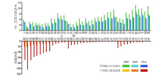
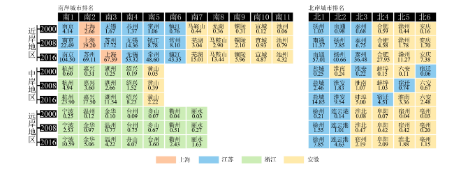
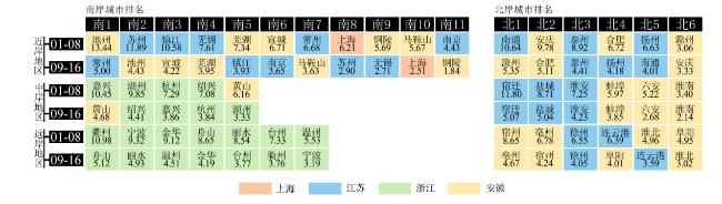
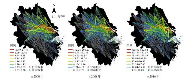
For a long time,there has been a gap between northern and southern bank area in the Yangtze River Delta (YRD). In order to achieve better cross-river cooperation,the cross Yangtze highway passage has played an important role in accelerating factor flows and coordinating the spatial linkage during the process of regional integration. Under the above background and from the perspective of spatial distance and administrative division,this paper studies the overall cross-river linkages of 41 cities and the characteristics of the spatial pattern in this area. The results are indicated as follows. 1) The construction of the river-crossing passages has significantly improved the accessibility between banks. There are distinct differences in cross-river linkage among cities in the YRD region. Specifically,cities with high level of linkages concentrating along the river,presenting a trend of decrease with distance from the river bank. In addition,the linkage level in the northern bank is relatively lower than that of the southern bank. Meanwhile,the growth of cross-river linkages presents a transport-oriented feature. The transport corridor acts as a crucial part in connecting cross-river bridges and farther cities,stimulating the developing potential of these cities and thus making some of these cities obtain better opportunities than the near-shore area. 2) Cross-river linkage intensity between city pairs demonstrates zonal distributed characteristics,which mainly manifested as inter- and intra-provincial differences. There are relatively high linkages between cities in Jiangsu and Shanghai,cities of northern Zhejiang. However,only the linkages between cities of southern Anhui and central Anhui exceed the average inside Anhui cities. Moreover,higher linkages are concentrated in intra-provincial cities,such as cities of south Jiangsu and central Jiangsu. Growth rate of inter-provincial linkage is greater than intra-provincial linkage. With the opening up of connecting channels between each province in Yangtze River Delta region,the cost of linkage between inter-provincial neighboring cities as well as regional peripheral regions and central cities has been greatly reduced. 3) Each passage has access utilization and hinterland differences. With the help of the cross-river channel network built earlier,the higher linkage network is further shifted to eastern regions such as Jiangsu and Zhejiang where the comprehensive urban strength is higher,so as to release the potential of river-crossing development in coastal areas. During the research period,the construction of cross-river channel has promoted north-south integration continuously. As a transport corridor composed of cross-river bridges and high-grade road network,the diversification of cross-river choice has enhanced the intensity of cross-river linkage. The construction of the "core-periphery" high-grade highway network in the Yangtze River Delta can be seen as an opportunity to strengthen the linkages between long-distance cities lying in northern and southern bank of the Yangtze River and also between peripheral cities. The cross Yangtze highway passages have lessened the extent of development imbalance generated by the difference of location in order to reconstruct the spatial pattern both in northern and southern bank of the Yangtze River,and thus to promote regional integration.
LIU Weichen , CAO Youhui , LIANG Shuangbo , GUO Jiaying . Spatial Effects of Cross Yangtze Highway Passage on Interurban Linkages in the Yangtze River Delta[J]. Economic geography, 2020 , 40(7) : 49 -56 . DOI: 10.15957/j.cnki.jjdl.2020.07.006
表1 长三角地区城市质量综合评价体系Tab.1 Evaluation index system of the comprehensive power among cities |
| 一级指标 | 二级指标 |
|---|---|
| 城市规模 | 常住人口(万人)、建成区面积(km2)、城市化率/城镇人口比重(%) |
| 经济发展 | GDP(亿元)、人均GDP(元)、GDP中第三产业占比(%)、人均固定资产投资额(元)、实际FDI(亿美元)、社会消费品零售总额(亿元)、地方财政收入(亿元) |
| 人民生活 | 人均城乡居民年末存款余额(元)、城镇居民人均可支配收入(元)、农村居民人均纯收入(元)、城镇居民人均住房面积(m2)、农村居民人均住房面积(m2) |
| 社会建设 | 万人拥有医疗机构床位数(张)、人均公共图书馆藏书量(册)、人均邮电业务量(元)、客运总量(万人)、货运总量(万t)、R&D支出(亿元) |
| 环境保护 | 建成区绿化覆盖率(%)、垃圾粪便年处理能力(万t)、三废综合利用率(%)、空气质量达到二级以上天数占比(%) |
表2 长江三角地区过江通道基本信息Tab.2 Basic information of cross Yangtze passages in the YRD |
| 过江通道名称 | 通车年份 | 通道限速 | 南岸城市 | 北岸城市 |
|---|---|---|---|---|
| 南京长江大桥 | 1968 | 50 km/h | 南京市 | 南京市 |
| 铜陵长江公路大桥 | 1995 | 60 km/h | 铜陵市 | 铜陵市 |
| 江阴长江大桥 | 1999 | 100 km/h | 江阴市 | 靖江市 |
| 芜湖长江大桥 | 2000 | 70 km/h | 芜湖市 | 芜湖市 |
| 江阴长江大桥 | 1999 | 100 km/h | 无锡市 | 泰州市 |
| 南京长江二桥 | 2001 | 100 km/h | 南京市 | 南京市 |
| 安庆长江大桥 | 2004 | 100 km/h | 池州市 | 安庆市 |
| 润扬长江大桥 | 2005 | 100 km/h | 镇江市 | 扬州市 |
| 苏通长江大桥 | 2008 | 100 km/h | 苏州市 | 南通市 |
| 南京长江隧道 | 2010 | 80 km/h | 南京市 | 南京市 |
| 南京长江四桥 | 2012 | 100 km/h | 南京市 | 南京市 |
| 泰州长江大桥 | 2012 | 100 km/h | 泰州市 | 扬中市 |
| 马鞍山长江大桥 | 2013 | 100 km/h | 马鞍山市 | 马鞍山市 |
| 铜陵长江公铁大桥 | 2015 | 100 km/h | 铜陵市 | 芜湖市 |
| 上海长江隧桥 | 2009 | 隧道:80 km/h | 上海市 | 南通市 |
| 桥梁:100 km/h | ||||
| 望东长江大桥 | 2016 | 100 km/h | 池州市 | 安庆市 |
| 南京扬子江隧道 | 2016 | 70 km/h | 南京市 | 南京市 |
表3 长三角地区城市对间过江联系强度特征Tab.3 Statistical characteristics of cross river linkages between cities on the YRD |
| 地区 | 类型 | 2000 | 2008 | 2016 | |||||||||||
|---|---|---|---|---|---|---|---|---|---|---|---|---|---|---|---|
| 苏北 | 苏中 | 皖北 | 皖中 | 苏北 | 苏中 | 皖北 | 皖中 | 苏北 | 苏中 | 皖北 | 皖中 | ||||
| 上海 | 均值 | 2.26 | 9.99 | 1.04 | 2.08 | 13.78 | 95.99 | 4.97 | 9.31 | 53.23 | 353.04 | 17.54 | 37.08 | ||
| 变异系数 | 0.43 | 0.13 | 0.54 | 0.58 | 0.57 | 0.95 | 0.39 | 0.53 | 0.61 | 0.79 | 0.36 | 0.66 | |||
| 苏南 | 均值 | 1.41 | 7.67 | 0.79 | 2.79 | 12.41 | 71.74 | 5.34 | 14.08 | 59.43 | 337.41 | 22.17 | 72.09 | ||
| 变异系数 | 0.74 | 0.57 | 1.11 | 1.76 | 0.65 | 0.59 | 0.87 | 1.33 | 0.63 | 0.53 | 0.87 | 1.53 | |||
| 皖南 | 均值 | 0.25 | 0.69 | 0.26 | 0.90 | 2.07 | 5.11 | 1.76 | 7.43 | 10.00 | 23.43 | 7.54 | 38.25 | ||
| 变异系数 | 0.75 | 0.94 | 1.01 | 1.00 | 0.70 | 0.81 | 0.84 | 0.90 | 0.68 | 0.78 | 0.79 | 0.98 | |||
| 浙东北 | 均值 | 0.35 | 1.17 | 0.19 | 0.38 | 3.16 | 13.27 | 1.47 | 3.09 | 15.87 | 64.91 | 6.48 | 16.03 | ||
| 变异系数 | 0.59 | 0.54 | 0.70 | 0.69 | 0.61 | 0.73 | 0.60 | 0.70 | 0.61 | 0.70 | 0.55 | 0.76 | |||
| 浙西南 | 均值 | 0.12 | 0.27 | 0.08 | 0.14 | 1.03 | 2.69 | 0.57 | 1.18 | 5.46 | 14.46 | 2.70 | 6.77 | ||
| 变异系数 | 0.47 | 0.40 | 0.53 | 0.45 | 0.41 | 0.42 | 0.43 | 0.50 | 0.45 | 0.46 | 0.36 | 0.57 | |||
| [1] |
姚士谋, 陈振光, 朱英明. 中国城市群[M]. 合肥: 中国科学技术大学出版社, 2006.
|
| [2] |
方创琳. 中国城市群研究取得的重要进展与未来发展方向[J]. 地理学报, 2014, 69(8):1 130-1 144.
|
| [3] |
顾朝林. 城市群研究进展与展望[J]. 地理研究, 2011, 30(5):771-784.
|
| [4] |
牛方曲, 刘卫东, 宋涛, 等. 城市群多层次空间结构分析算法及其应用——以京津冀城市群为例[J]. 地理研究, 2015, 34(8):1 447-1 460.
|
| [5] |
陆玉麒. 区域双核结构理论[M]. 北京: 商务应书馆, 2016.
|
| [6] |
李玉江. 城市群形成动力机制及综合竞争力提升研究[M]. 北京: 科学出版社, 2009.
|
| [7] |
|
| [8] |
闫卫阳, 王发曾, 秦耀辰. 城市空间相互作用理论模型的演进与机理[J]. 地理科学进展, 2009, 28(4):511-518.
|
| [9] |
张贞冰, 陈银蓉, 赵亮, 等. 基于中心地理论的中国城市群空间自组织演化解析[J]. 经济地理, 2014, 34(7):44-51.
|
| [10] |
梅志雄, 徐颂军, 欧阳军, 等. 近20年珠三角城市群城市空间相互作用时空演变[J]. 地理科学, 2012, 32(6):694-701.
|
| [11] |
刘玮辰, 陆玉麒, 徐旳. 南京都市圈空间相互作用时空演变分析[J]. 人文地理, 2017(2):65-71.
|
| [12] |
何胜, 唐承丽, 周国华. 长江中游城市群空间相互作用研究[J]. 经济地理, 2014, 34(4):46-53.
|
| [13] |
关伟, 周忻桐. 辽中南城市群空间相互作用的时空演变[J]. 经济地理, 2014, 34(9):48-55.
|
| [14] |
吴建楠, 程绍铂, 姚士谋. 中国城市群空间结构研究进展[J]. 现代城市研究, 2013(12):97-101.
|
| [15] |
方创琳, 王振波, 马海涛. 中国城市群形成发育规律的理论认知与地理学贡献[J]. 地理学报, 2018, 73(4):651-665.
|
| [16] |
崔功豪, 王本炎, 查彦玉. 城市地理学[M]. 南京: 江苏教育出版社, 1992.
|
| [17] |
孙阳, 姚士谋, 张落成. 中国沿海三大城市群城市空间网络拓展分析——以综合交通信息网络为例[J]. 地理科学, 2018, 38(6):827-937.
|
| [18] |
王姣娥, 焦敬娟, 金凤君. 高速铁路对中国城市空间相互作用强度的影响[J]. 地理学报, 2014, 69(12):1 833-1 846.
|
| [19] |
侯贺平, 刘艳芳, 李纪伟, 等. 不同模型在镇域空间相互作用中的应用与比较分析——以湖北省大冶市为例[J]. 人文地理, 2014(5):63-68.
|
| [20] |
|
| [21] |
|
| [22] |
陶卓霖, 戴特奇, 郑清菁, 等. 空间相互作用模型中的目的地竞争效应——基于中国城市间铁路客流数据的实证研究[J]. 地理科学, 2017, 37(2):181-189.
|
| [23] |
|
| [24] |
焦敬娟, 王姣娥, 金凤君, 等. 高速铁路对城市网络结构的影响研究——基于铁路客运班列分析[J]. 地理学报, 2016, 71(2):265-280.
|
| [25] |
孟德友, 冯兴华, 文玉钊. 铁路客运视角下东北地区城市网络结构演变及组织模式探讨[J]. 地理研究, 2017, 36(7):1 339-1 352.
|
| [26] |
蒋海兵, 祁毅, 李传武. 中国城市高速铁路客运的空间联系格局[J]. 经济地理, 2018, 38(7):26-33.
|
| [27] |
吴威, 曹有挥, 曹卫东, 等. 开放条件下长江三角洲区域的综合交通可达性空间格局[J]. 地理研究, 2007, 26(2):391-402.
|
| [28] |
吴威, 陈雯, 曹有挥. 过江通道建设对相对落后地区发展的影响——以江苏省南通市为例[J]. 长江流域资源与环境, 2009, 18(5):397-402.
|
| [29] |
吴旗韬, 樊杰, 张虹鸥, 等. 跨海通道空间效益模型——以珠江口跨海通道为例[J]. 地理研究, 2015, 34(11):2 061-2 072.
|
| [30] |
吴旗韬, 张虹鸥, 叶玉瑶, 等. 基于交通可达性的港珠澳大桥时空压缩效应[J]. 地理学报, 2012, 67(6):723-732.
|
| [31] |
|
| [32] |
孙峰华, 陆大道, 柳新华, 等. 中国物流发展对渤海海峡跨海通道建设的影响[J]. 地理学报, 2010, 65(12):1 507-1 521.
|
| [33] |
李平华, 陆玉麒. 可达性研究的回顾与展望[J]. 地理科学进展, 2005, 24(3):71-80.
|
| [34] |
陈娱, 金凤君, 陆玉麒, 等. 京津冀地区陆路交通网络发展过程及可达性演变特征[J]. 地理学报, 2017, 72(12):2 252-2 264.
|
/
| 〈 |
|
〉 |