
Spatial Structure Identification and Influence Mechanism of Miao Traditional Villages in Guizhou Province
Received date: 2020-04-20
Revised date: 2020-11-07
Online published: 2025-04-01
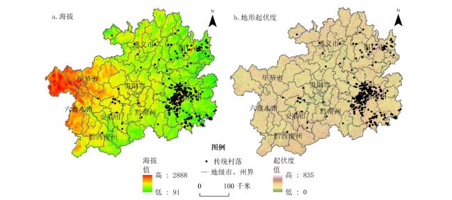
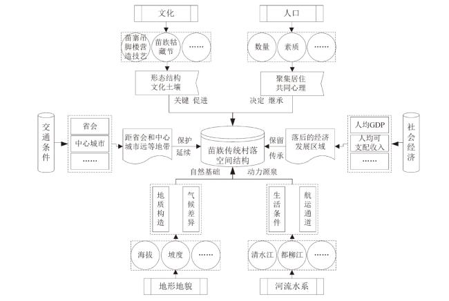
Miao traditional villages are important carriers of regional culture,national unity and interest relationship. A systematic study of the spatial distribution of these villages is greatly significant for protecting traditional villages and realizing rural revitalization. Using the methods of kernel density analysis,grid dimension analysis,spatial correlation analysis and geodetector,the paper scientifically identifies the spatial structure of Miao traditional villages and explores the influencing mechanism. The results show that: 1) Spatial distribution of Miao traditional villages in Guizhou Province shows a tendency of agglomeration and significant spatial heterogeneity. The maximum kernel density is in the Leikaitai area,which is featured by an inclined "T" shape. 2) Miao traditional villages,as a scale-free area, have obvious fractal structure characteristics. The self-organization evolution spreads around the regions of the Qingshui River and Duliu River,and the fractal structure is extremely complex. 3) The Miao traditional villages have a significant positive spatial correlation,showing the distribution of hot spots in the southeast and cold spots in the southwest-northeast. 4) Miao traditional villages are concentrated in the areas with an elevation of 500-1000 m,terrain relief of 30-70 m,the slope of 5-15°,mainly around Qingshui River and Duliu River where traffic is congested. The natural geographical environment plays a fundamental role in the spatial distribution pattern of Miao traditional villages. The determining factors are the Miao culture and population distribution. Backward economic development level and blocked traffic conditions can be the protective effects.
YANG Yan , HU Jing , LIU Dajun , JIA Yaoyan , JIANG Liang . Spatial Structure Identification and Influence Mechanism of Miao Traditional Villages in Guizhou Province[J]. Economic geography, 2021 , 41(2) : 232 -240 . DOI: 10.15957/j.cnki.jjdl.2021.02.025
表1 贵州省苗族传统村落网格维数测算数据Tab.1 Grid dimension of Miao traditional villages in Guizhou Province |
| K | 2 | 3 | 4 | 5 | 6 | 7 | 8 | 9 | 10 |
|---|---|---|---|---|---|---|---|---|---|
| 4 | 8 | 11 | 14 | 18 | 23 | 27 | 30 | 34 | |
| 0.6148 | 1.2229 | 1.5175 | 1.9791 | 1.8566 | 2.2090 | 2.4564 | 2.6792 | 2.5952 |
表2 贵州省苗族传统村落全局Moran's I指数Tab.2 Global Moran's I index of of Miao traditional villages in Guizhou Province |
| 全局Moran's I指数 | 0.6718 |
|---|---|
| 预期指数 | -0.0278 |
| 方差 | 0.0166 |
| z得分 | 5.4257 |
| p值 | 0.0000 |
表3 贵州省苗族传统村落所在坡度统计表Tab.3 Slope statistics of Miao traditional villages in Guizhou Province |
| 坡度分级 | 坡度(°) | 村落数量(个) | 占比(%) |
|---|---|---|---|
| 平原至微倾斜平原 | 0~2 | 12 | 4.20 |
| 缓斜坡 | 2~5 | 28 | 9.79 |
| 斜坡 | 5~15 | 119 | 41.61 |
| 陡坡 | 15~25 | 92 | 32.17 |
| 急坡 | 25~35 | 27 | 9.44 |
| 急陡坡 | 35~55 | 8 | 2.80 |
表4 贵州省苗族传统村落所在坡向统计表Tab.4 Aspect statistics of Miao traditional villages in Guizhou Province |
| 坡向 | 坡向范围(°) | 村落数量(个) | 占比(%) |
|---|---|---|---|
| 北坡 | 0~45和315~360 | 61 | 21.33 |
| 东坡 | 45~135 | 73 | 25.52 |
| 南坡 | 135~225 | 86 | 30.07 |
| 西坡 | 225~315 | 66 | 23.08 |
| 阳坡 | 90~270 | 171 | 59.79 |
| 阴坡 | 0~90,270~360 | 115 | 40.21 |
表5 贵州省河流缓冲区苗族传统村落分布表Tab.5 Distribution of Miao traditional villages in the river buffer zone of Guizhou Province |
| 距河流距离(km) | <2 | 2~4 | 4~6 | 6~8 | 8~10 | >10 |
|---|---|---|---|---|---|---|
| 村落数量(个) | 74 | 71 | 52 | 45 | 30 | 14 |
| 占比(%) | 25.87 | 24.83 | 18.18 | 15.73 | 10.49 | 4.90 |
图4 贵州省苗族传统村落空间结构影响机制Fig.4 Influence mechanism of Miao traditional villages in Guizhou Province |
表6 贵州省苗族传统村落空间分异影响因子探测结果Tab.6 Result of potential determinants affecting spatial difference of Miao traditional villages in Guizhou Province |
| 序号 | 探测因子 | 指标因素 | q值 |
|---|---|---|---|
| X1 | 地形地貌 | 海拔 | 0.4962*** |
| 地形起伏度 | 0.4031 | ||
| X2 | 坡向坡度 | 坡向 | 0.2494 |
| 坡度 | 0.5076* | ||
| X3 | 河流水系 | 河网密度 | 0.5126*** |
| X4 | 社会经济 | 人均GDP | 0.3948 |
| 农村人均可支配收入 | 0.4598* | ||
| X5 | 人口数量 | 年末苗族人口 | 0.7695** |
| X6 | 交通条件 | 公路通车里程数 | 0.5940* |
| X7 | 文化遗产 | 苗族非物质文化遗产数量 | 0.8680*** |
注:*、**和***分别表示在10%、5%和1%水平下显著。 |
| [1] |
卢松, 张小军, 张业臣. 徽州传统村落的时空分布及其影响因素[J]. 地理科学, 2018, 37(10):1690-1698.
|
| [2] |
|
| [3] |
|
| [4] |
|
| [5] |
|
| [6] |
汪德根, 吕庆月, 吴永发, 等. 中国传统民居建筑风貌地域分异特征与形成机理[J]. 自然资源学报, 2019, 33(9):1864-1885.
|
| [7] |
李任, 姚伟钧. 传统村落视域下耕读文化发展初探——以黄陂大余湾为中心的考察[J]. 中国农史, 2017, 36(4):93-101.
|
| [8] |
王军, 夏健. 传统村落保护的动态监控体系建构研究[J]. 城市发展研究, 2016, 23(7):58-63.
|
| [9] |
高楠, 邬超, 白凯, 等. 中国传统村落空间分异及影响因素[J]. 陕西师范大学学报:自然科学版, 2020, 48(4):97-107.
|
| [10] |
刘大均, 胡静, 陈君子, 等. 中国传统村落的空间分布格局研究[J]. 中国人口·资源与环境, 2014, 24(4):157-162.
|
| [11] |
熊梅. 中国传统村落的空间分布及其影响因素[J]. 北京理工大学学报:社会科学版, 2014, 16(5):153-158.
|
| [12] |
李江苏, 王晓蕊, 李小建. 中国传统村落空间分布特征与影响因素分析[J]. 经济地理, 2020, 40(2):143-153.
|
| [13] |
王兆峰, 刘庆芳. 中国少数民族特色村寨空间异质性特征及其影响因素[J]. 经济地理, 2019, 39(11):150-158.
|
| [14] |
何小芊, 龚胜生, 胡娟, 等. 基于不同尺度的湘鄂赣地区传统村落空间分异及影响因素[J]. 长江流域资源与环境, 2019, 27(12):2857-2866.
|
| [15] |
冯亚芬, 俞万源, 雷汝林. 广东省传统村落空间分布特征及影响因素研究[J]. 地理科学, 2017, 36(2):79-86.
|
| [16] |
胡震, 赵翠薇, 李朝仙, 等. 喀斯特高原峡谷区少数民族村寨空间分布格局及影响因素研究——以贵州省威宁县为例[J]. 山地学报, 2019, 37(4):575-588.
|
| [17] |
胡震, 赵翠薇, 李朝仙, 等. 乌蒙山区少数民族村寨空间分布特征研究——以威宁县彝族、回族村寨为例[J]. 中国农业资源与区划, 2019, 39(4):135-146.
|
| [18] |
杨京彪, 吕靓, 杜世宏. 黔东南苗族侗族自治州民族村寨空间分布特征研究[J]. 北京大学学报:自然科学版, 2015, 60(3):444-450.
|
| [19] |
王丹, 郭泺, 吕靓. 黔东南山地苗族与侗族村寨空间分布特征的分异[J]. 生态科学, 2015, 33(1):44-52.
|
| [20] |
金潇骁. 吊脚楼“景观”的文化解读——以贵州西江苗寨为例[J]. 贵州民族研究, 2013, 34(4):55-58.
|
| [21] |
孙琳, 邓爱民, 张洪昌. 民族传统村落旅游活化的困境与纾解——以黔东南州雷山县为例[J]. 贵州民族研究, 2019, 40(6):53-58.
|
| [22] |
陈国磊, 田玲玲, 罗静, 等. 长江经济带城市黑臭水体空间分布格局及影响因子[J]. 长江流域资源与环境, 2019, 28(5):3-14.
|
| [23] |
贾垚焱, 胡静, 刘大均, 等. 长江中游城市群A级旅游景区空间演化及影响机理[J]. 经济地理, 2019, 39(1):198-206.
|
| [24] |
王劲峰, 徐成东. 地理探测器:原理与展望[J]. 地理学报, 2017, 72(1):116-134.
|
| [25] |
刘元保, 唐克丽. 国内外坡度分级和王东沟试验区的坡度组成[J]. 水土保持通报, 1987, 6(3):59-65.
|
| [26] |
梁步青, 肖大威, 陶金, 等. 赣州客家传统村落分布的时空格局与演化[J]. 经济地理, 2018, 38(8):196-203.
|
| [27] |
陈国磊, 罗静, 曾菊新, 等. 中国少数民族特色村寨空间结构识别及影响机理研究[J]. 地理科学, 2018, 38(9):1422-1429.
|
| [28] |
李孜沫. 汾河流域古村落的时空演化与形成机理[J]. 经济地理, 2019, 39(2):207-214.
|
| [29] |
佟玉权, 龙花楼. 贵州民族传统村落的空间分异因素[J]. 经济地理, 2015, 35(3):133-137.
|
/
| 〈 |
|
〉 |

