
Spatio-temporal Characteristic of Urban-Rural Integration Development Level in Hainan Free Trade Port and Its Driving Mechanism
Received date: 2024-04-10
Revised date: 2024-07-14
Online published: 2025-01-21
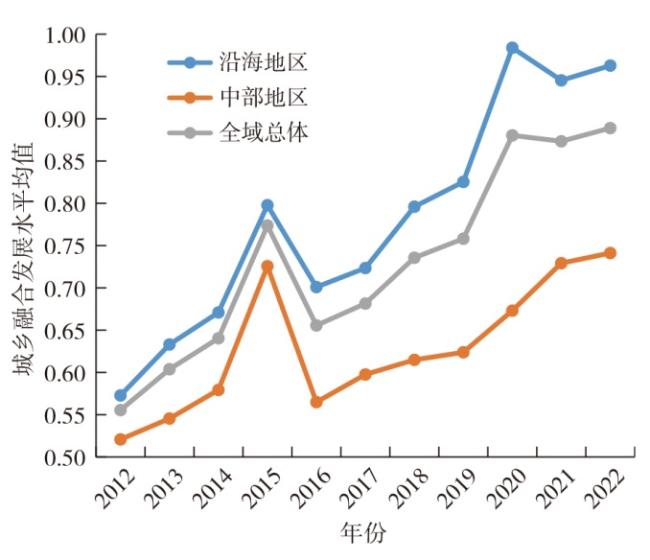
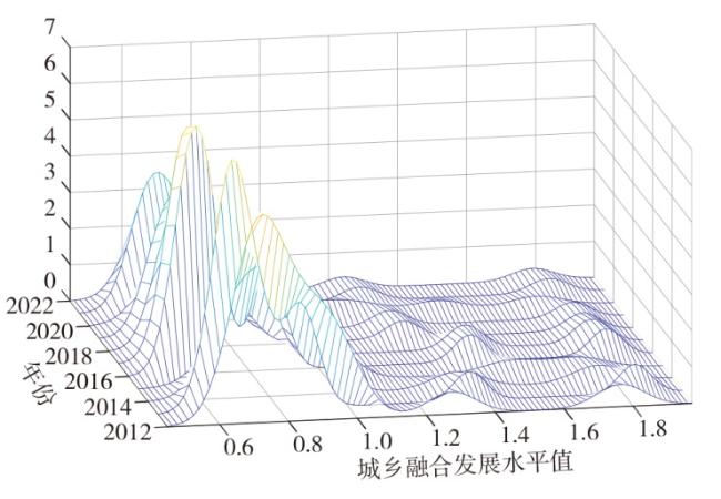
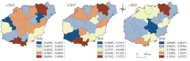
Taking the 18 cities and counties of Hainan Free Trade Port as the research unit and using the real coding based accelerating genetic algorithm and projection pursuit classification model (RAGA-PPC), this paper measures the level of urban-rural integration development from 2012 to 2022, and adopts the kernel density method, GIS spatial analysis, and the random forest model to explore the characteristics of the spatial and temporal evolution of the level of urban-rural integration development and its driving mechanism. It's found that: 1) The level of urban-rural integration development of Hainan Free Trade Port presents a good trend and there is an obvious stage characteristics of M-shaped chronological evolutionary and multi-level differentiation trend of "1 main peak + 2 side peaks". 2) The overall level has changed from an inverted "V" structure with a "low-high-low" pattern from the east of Hainan Free Trade Port to the west of Hainan Free Trade Port in the early part of the study to a distribution with a concentration of high values at the north and south ends and a low-level polarisation in the central part running through the east and west of Hainan Free Trade Port in the late part of the study. 3) Agricultural development scale and transportation accessibility are strong influence-type dominant factors, the ratio of financial support for agriculture, openness to the outside world, government intervention and other factors are influence-type contributing factors, while the degree of education support is a weak influence-type factor, and the changes in the marginal influence of the driving factors and the reflective and receptive capacity of the funds, platforms, channels, and policies among the regions are the fundamental reasons for the spatio-temporal heterogeneity.
GUO Qingbin , MA Mengyao , CHENG Yeqing . Spatio-temporal Characteristic of Urban-Rural Integration Development Level in Hainan Free Trade Port and Its Driving Mechanism[J]. Economic geography, 2024 , 44(12) : 62 -71 . DOI: 10.15957/j.cnki.jjdl.2024.12.007
表1 区域城乡融合发展水平测度指标体系Tab.1 Indicator system for measuring the level of regional urban-rural integration development |
| 子系统 | 指标层 | 指标计算或描述 | 属性 |
|---|---|---|---|
| 经济融合(A) | 城乡人均GDP(A1) | 城乡GDP/地区常住人口(万元/人) | 正 |
| 城乡可支配收入比(A2) | 城市居民可支配收入/农村居民可支配收入(%) | 负 | |
| 二元对比系数(A3) | (第一产业产值/第一产业从业人数)/(第二、三产业产值/第二、三产业从业人数)(%) | 正 | |
| 二、三产业对 GDP 的贡献(A4) | 第二、三产业生产总值和/GDP(%) | 正 | |
| 社会融合(B) | 城乡养老保险覆盖率(B1) | 城乡居民养老保险参保人数/常住人口数(%) | 正 |
| 城乡失业保险覆盖率(B2) | 城乡居民失业保险参保人数/常住人口数(%) | 正 | |
| 城乡最低生活保障比(B3) | 城镇居民最低生活保障人数/农村居民最低生活保障人数(%) | 正 | |
| 要素融合(C) | 非农与农业从业比(C1) | 第二、三产业从业人数/第一产业从业人数(%) | 正 |
| 人口城镇化水平(C2) | 城镇居住人口/常住人口(%) | 正 | |
| 财政支农比(C3) | 支农支出/财政支出(%) | 正 | |
| 空间融合(D) | 公路交通网密度(D1) | 公路运营里程/土地总面积(%) | 正 |
| 城市空间扩(D2) | 农作物总播种面积/建成区面积(%) | 正 | |
| 城乡人口比(D3) | 城镇居住人口/农村居住人口(%) | 负 | |
| 土地城镇化水平(D4) | 建成区面积/土地总面积(%) | 正 | |
| 生态融合(E) | 耕地与建设用地效率比(E1) | (第一产业产值/耕地面积)/(第二、三产业产值/建成区面积)(%) | 正 |
| 环保支出占财政支出比重(E2) | 环保支出/财政支出(%) | 正 |
| [1] |
潘子纯, 马林燕, 田蓬鹏, 等. 东北三省城乡融合发展的时空演变与区域差异及其收敛性研究[J]. 自然资源报, 2023, 38(12):3093-3115.
|
| [2] |
崔树强, 周国华, 戴柳燕, 等. 基于地理学视角的城乡融合发展研究进展与展望[J]. 经济地理, 2022, 42(2):104-113.
|
| [3] |
龙花楼, 徐雨利, 郑瑜晗, 等. 中国式现代化下的县域城乡融合发展[J]. 经济地理, 2023, 43(7):12-19.
|
| [4] |
周德, 戚佳玲, 钟文钰. 城乡融合评价研究综述:内涵辨识、理论认知与体系重构[J]. 自然资源学报, 2021, 36(10):2634-2651.
|
| [5] |
何仁伟. 城乡融合与乡村振兴:理论探讨、机理阐释与实现路径[J]. 地理研究, 2018, 37(11):2127-2140.
|
| [6] |
张海鹏. 中国城乡关系演变70年:从分割到融合[J]. 中国农村经济, 2019(3):2-18.
|
| [7] |
刘春芳, 张志英. 从城乡一体化到城乡融合:新型城乡关系的思考[J]. 地理科学, 2018, 38(10):1624-1633.
|
| [8] |
|
| [9] |
施建刚, 段锴丰, 吴光东. 长三角地区城乡融合发展水平测度及其时空特征分析[J]. 同济大学学报(社会科学版), 2022, 33(1):78-89.
|
| [10] |
周佳宁, 秦富仓, 刘佳, 等. 多维视域下中国城乡融合水平测度、时空演变与影响机制[J]. 中国人口·资源与境, 2019, 29(9):166-176.
|
| [11] |
马志飞, 宋伟轩, 王捷凯, 等. 长三角地区城乡融合发展水平、演化及影响因素[J]. 自然资源学报, 2022, 37(6):1467-1480.
|
| [12] |
张海朋, 何仁伟, 李光勤, 等. 大都市区城乡融合系统耦合协调度时空演化及其影响因素——以环首都地区为例[J]. 经济地理, 2020, 40(11):56-67.
|
| [13] |
张新林, 仇方道, 朱传耿. 时空交互视角下淮海经济区城乡融合发展水平演化[J]. 自然资源学报, 2020, 35(8):1867-1880.
|
| [14] |
郑瑜晗, 龙花楼. 中国城乡融合发展测度评价及其时空格局[J]. 地理学报, 2023, 78(8):1869-1887.
|
| [15] |
周德, 钟文钰, 张佳文, 等. 县域城乡融合评价及差异化发展路径——以浙江山区26县为例[J]. 地理科学, 2023, 43(10):1803-1814.
|
| [16] |
张伟丽, 魏瑞博, 王伊斌, 等. 黄河流域经济高质量发展趋同俱乐部空间格局及演变[J]. 生态经济, 2023, 39(4):58-66,88.
|
| [17] |
|
| [18] |
周德, 戚佳玲, 钟文钰, 等. 城市群城乡融合发展:测度评价、障碍因素与驱动因素[J]. 地理研究, 2023, 42(11):2914-2939.
|
| [19] |
蔡绍洪, 谷城, 张再杰. 西部新型城镇化与乡村振兴协调的时空特征及影响机制[J]. 中国农业资源与区划, 2022, 43(12):202-213.
|
| [20] |
黄禹铭. 东北三省城乡协调发展格局及影响因素[J]. 地理科学, 2019, 39(8):1302-1311.
|
| [21] |
周佳宁, 邹伟, 秦富仓. 等值化理念下中国城乡融合多维审视及影响因素[J]. 地理研究, 2020, 39(8):1836-1851.
|
| [22] |
岳文泽, 钟鹏宇, 甄延临, 等. 从城乡统筹走向城乡融合:缘起与实践[J]. 苏州大学学报(哲学社会科学版), 2021, 42(4):52-61.
|
| [23] |
罗必良, 耿鹏鹏. 理解县域内的城乡融合发展[J]. 南京农业大学学报(社会科学版), 2023, 23(1):16-28.
|
| [24] |
黄永春, 宫尚俊, 邹晨, 等. 数字经济、要素配置效率与城乡融合发展[J]. 中国人口·资源与环境, 2022, 32(10):77-87.
|
| [25] |
辛金国, 张虹虹. 绿色发展推动城乡融合发展研究——基于PVAR与门槛模型的实证检验[J]. 调研世界, 2023(2):3-12.
|
| [26] |
舒季君, 周建平, 陈亦婷, 等. 中国省域数字经济的空间演化特征及其城乡融合效应[J]. 经济地理, 2022, 42(8):103-111.
|
| [27] |
赵伟, 黄兰, 李威, 等. 中国乡村包容性绿色发展水平分异及其驱动因素[J]. 经济地理, 2023, 43(3):68-77.
|
| [28] |
|
| [29] |
|
| [30] |
郭庆宾, 黄林峰. 海南自贸港金融服务实体经济效率的时空异质性及其驱动机理[J]. 地理科学进展, 2023, 42(1):53-65.
|
| [31] |
郭庆宾, 黄林峰. 海南省金融服务实体经济效率的空间网络及其溢出效应[J]. 经济地理, 2023, 43(5):68-77.
|
| [32] |
车冰清, 朱传耿, 仇方道. 淮海经济区城乡空间融合格局及形成机制[J]. 自然资源学报, 2020, 35(8):1897-1907.
|
| [33] |
罗婉璐, 王武林, 林珍, 等. 中国城乡融合时空演化及驱动因素[J]. 地理科学进展, 2023, 42(4):629-643.
|
| [34] |
徐维祥, 郑金辉, 徐志雄, 等. 中国城乡一体化水平的时空特征与门槛效应[J]. 长江流域资源与环境, 2020, 29(5):1051-1063.
|
| [35] |
徐雪, 王永瑜. 中国乡村振兴水平测度、区域差异分解及动态演进[J]. 数量经济技术经济研究, 2022, 39(5):64-83.
|
| [36] |
李玉恒, 黄惠倩, 王晟业. 基于乡村经济韧性的传统农区城乡融合发展路径研究——以河北省典型县域为例[J]. 经济地理, 2021, 41(8):28-33,44.
|
| [37] |
崔红茶, 陈新, 陈辞, 等. 长江流域少数民族特色村寨空间异质性及形成机理[J]. 经济地理, 2023, 43(9):160-171.
|
/
| 〈 |
|
〉 |