
Spatiotemporal Distribution Characteristics of Cultural Heritage and Their Association With Natural Environment in Meishan Area
Received date: 2023-06-19
Revised date: 2024-02-20
Online published: 2024-09-12
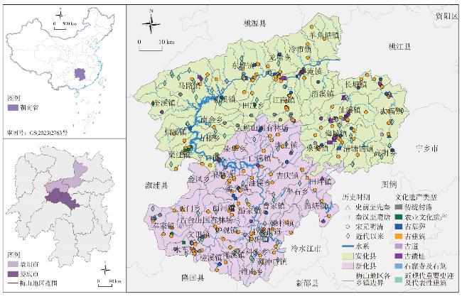
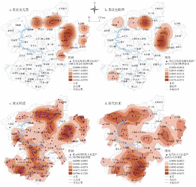
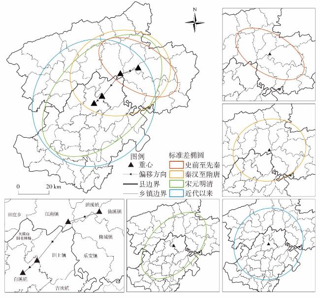
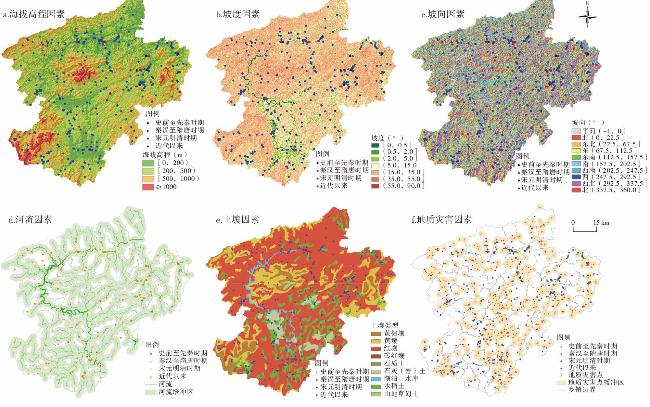
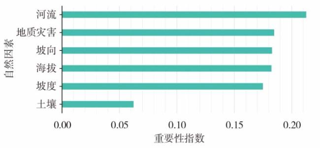
The Meishan area is rich in distinct cultural heritage landscapes and has distinctive characteristics. The spatiotemporal distribution features of cultural heritage landscapes reflect the evolution law of human settlement space in central Hunan,which have great significance for integrated preservation,systematic management,and localized adaptation of cultural heritages. This study investigates Meishan's protected cultural relics,agricultural heritages,traditional villages,and ancient paths,uses the spatial analysis to examine the spatial distribution of cultural heritages at various periods and their association with the natural environment,and using the random forest model to analyze the impact of natural factors on the distribution of cultural heritages. Findings indicate that: 1) Cultural heritages showed the randomly distribution from the period of Qin Dynasty-Han Dynasty to the period of Sui Dynasty-Tang Dynasty,whereas in other historical periods,it exhibited a clustered distribution. 2) Distribution patterns varied significantly with time,showing a high-density shift from the middle and lower to the upper reaches of the Zijiang River. 3) The distribution center of cultural heritages is shifting towards the southwest of the Meishan area,the aggregation degree is changing from agglomeration to dispersion. 4) Influenced by natural conditions,these cultural heritages primarily distributed in plains or hills below 500 meters elevation,on slopes with 2° to 15° inclines,more than 1 km away from geological disaster zones,with a higher concentration within 1km of rivers and in lateritic regions. 5) Rivers are the primary influencing factor on the cultural heritage distribution in this area,followed by geological disasters and topographic factors, soil factor is of least importance.
HUANG Xuejia , SHEN Shouyun , HU Xijun , LIAO Qiulin , TONG Yao , CAO Yuchi , SUN Xinpeng . Spatiotemporal Distribution Characteristics of Cultural Heritage and Their Association With Natural Environment in Meishan Area[J]. Economic geography, 2024 , 44(3) : 218 -228 . DOI: 10.15957/j.cnki.jjdl.2024.03.022
表1 各历史时期梅山地区不同类型文化遗产数量及占比Tab.1 Types and proportion of cultural heritages in Meishan area at each historical period |
| 文化遗产类型 | 史前至先秦 | 秦汉至隋唐 | 宋元明清 | 近代以来 | 总计 | |||||||||
|---|---|---|---|---|---|---|---|---|---|---|---|---|---|---|
| 数量(处) | 占比(%) | 数量(处) | 占比(%) | 数量(处) | 占比(%) | 数量(处) | 占比(%) | 数量(处) | 占比(%) | |||||
| 古遗址 | 15 | 88.24 | 13 | 86.66 | 26 | 9.81 | - | - | 54 | 13.81 | ||||
| 古墓葬 | 2 | 11.76 | 1 | 6.67 | 35 | 13.21 | - | - | 38 | 9.72 | ||||
| 古建筑 | - | - | - | - | 162 | 61.13 | - | - | 162 | 41.43 | ||||
| 石窟寺及石刻 | - | - | - | - | 11 | 4.15 | - | - | 11 | 2.81 | ||||
| 近现代重要史迹及代表性建筑 | - | - | - | - | - | - | 92 | 97.87 | 92 | 23.53 | ||||
| 农业文化遗产 | - | - | 1 | 6.67 | 6 | 2.26 | 2 | 2.13 | 9 | 2.30 | ||||
| 传统村落 | - | - | - | - | 20 | 7.55 | - | - | 20 | 5.12 | ||||
| 古道 | - | - | - | - | 5 | 1.89 | - | - | 5 | 1.28 | ||||
表2 历史时期梅山地区文化遗产最邻近指数和空间分布模式Tab.2 Nearest neighbor index and spatial distribution patterns of cultural heritages in Meishan area at each historical period |
| 历史时期 | 文化遗产数量(个) | 平均观测距离(m) | 预期平均距离(m) | 最邻近比率 | Z得分 | 分布模式 |
|---|---|---|---|---|---|---|
| 史前至先秦 | 17 | 4130.6971 | 6663.1778 | 0.619929 | -2.997920 | 集聚 |
| 秦汉至隋唐 | 15 | 9511.6994 | 9573.2056 | 0.993575 | -0.047603 | 随机 |
| 宋元明清 | 265 | 2037.8503 | 3067.4676 | 0.664343 | -10.433468 | 集聚 |
| 近代以来 | 94 | 3839.9442 | 5189.0437 | 0.740010 | -4.822269 | 集聚 |
图4 梅山地区各时期文化遗产在不同自然因素下的空间分布Fig.4 Spatial distribution of cultural heritage in the Meishan area in different periods under different natural factors |
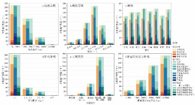
图5 不同文化遗产属性受6个自然因素影响的数据分析Fig.5 Relationship between the number of cultural heritages and natural factors |
表3 历史时期梅山地区文化遗产分布与海拔高程关系Tab.3 Relationship between cultural heritage distribution and elevation in the Meishan area at each historical period |
| 海拔高程(m) | 史前至先秦 | 秦汉至隋唐 | 宋元明清 | 近代以来 | 总计 | |||||||||
|---|---|---|---|---|---|---|---|---|---|---|---|---|---|---|
| 数量(处) | 占比(%) | 数量(处) | 占比(%) | 数量(处) | 占比(%) | 数量(处) | 占比(%) | 数量(处) | 占比(%) | |||||
| [0,200) | 13 | 76.47 | 12 | 80.00 | 138 | 52.08 | 47 | 50.00 | 210 | 53.71 | ||||
| [200,500) | 4 | 23.53 | 2 | 13.33 | 100 | 37.74 | 33 | 35.11 | 139 | 35.55 | ||||
| [500,1000) | - | - | 1 | 6.67 | 25 | 9.43 | 14 | 14.89 | 40 | 10.23 | ||||
| ≥1000 | - | - | - | - | 2 | 0.75 | - | - | 2 | 0.51 | ||||
表4 历史时期梅山地区文化遗产分布与坡度关系Tab.4 Relationship between cultural heritage distribution and slope gradient in the Meishan area at each historical period |
| 坡度等级(°) | 史前至先秦 | 秦汉至隋唐 | 宋元明清 | 近代以来 | 总计 | |||||||||
|---|---|---|---|---|---|---|---|---|---|---|---|---|---|---|
| 数量(处) | 占比(%) | 数量(处) | 占比(%) | 数量(处) | 占比(%) | 数量(处) | 占比(%) | 数量(处) | 占比(%) | |||||
| 0.0~0.5 | - | - | - | - | 7 | 2.64 | 4 | 4.26 | 11 | 2.81 | ||||
| 0.6~2.0 | 2 | 11.76 | 2 | 13.33 | 15 | 5.66 | 5 | 5.32 | 24 | 6.14 | ||||
| 2.1~5.0 | 6 | 35.29 | 8 | 53.33 | 57 | 21.51 | 24 | 25.53 | 95 | 24.30 | ||||
| 5.1~15.0 | 8 | 47.06 | 4 | 26.67 | 118 | 44.53 | 38 | 40.43 | 168 | 42.97 | ||||
| 15.1~35.0 | 1 | 5.88 | 1 | 6.67 | 60 | 22.64 | 22 | 23.40 | 84 | 21.48 | ||||
| 35.1~55.0 | - | - | - | - | 8 | 3.02 | 1 | 1.06 | 9 | 2.30 | ||||
| 55.1~90.0 | - | - | - | - | - | - | - | - | - | - | ||||
表5 历史时期梅山地区文化遗产分布与坡向关系Tab.5 Relationship between cultural heritage distribution and slope direction in the Meishan area at each historical period |
| 坡向 | 史前至先秦 | 秦汉至隋唐 | 宋元明清 | 近代以来 | 总计 | |||||||||
|---|---|---|---|---|---|---|---|---|---|---|---|---|---|---|
| 数量(处) | 占比(%) | 数量(处) | 占比(%) | 数量(处) | 占比(%) | 数量(处) | 占比(%) | 数量(处) | 占比(%) | |||||
| 正北 | 1 | 5.88 | 1 | 6.67 | 32 | 12.08 | 7 | 7.45 | 41 | 10.49 | ||||
| 东北 | 4 | 23.53 | 2 | 13.33 | 30 | 11.32 | 11 | 11.70 | 47 | 12.02 | ||||
| 正东 | 1 | 5.88 | - | - | 36 | 13.58 | 10 | 10.64 | 47 | 12.02 | ||||
| 东南 | 2 | 11.76 | 4 | 26.67 | 32 | 12.08 | 14 | 14.89 | 52 | 13.30 | ||||
| 正南 | 2 | 11.76 | 3 | 20.00 | 29 | 10.94 | 14 | 14.89 | 48 | 12.28 | ||||
| 西南 | 2 | 11.76 | 1 | 6.67 | 40 | 15.09 | 9 | 9.57 | 52 | 13.30 | ||||
| 正西 | - | - | 1 | 6.67 | 27 | 10.19 | 14 | 14.89 | 42 | 10.74 | ||||
| 西北 | 5 | 29.41 | 3 | 20.00 | 32 | 12.08 | 11 | 11.70 | 51 | 13.04 | ||||
表6 历史时期梅山地区文化遗产分布与河流关系Tab.6 Relationship between cultural heritage distribution and rivers in the Meishan area at each historical period |
| 距河流距离(km) | 史前至先秦 | 秦汉至隋唐 | 宋元明清 | 近代以来 | 总计 | |||||||||
|---|---|---|---|---|---|---|---|---|---|---|---|---|---|---|
| 数量(处) | 占比(%) | 数量(处) | 占比(%) | 数量(处) | 占比(%) | 数量(处) | 占比(%) | 数量(处) | 占比(%) | |||||
| <1 | 17 | 100 | 13 | 86.67 | 203 | 76.60 | 68 | 72.34 | 301 | 76.98 | ||||
| [1,2) | - | - | 2 | 13.33 | 45 | 16.98 | 11 | 11.70 | 58 | 14.83 | ||||
| [2,5) | - | - | - | - | 17 | 6.42 | 14 | 14.89 | 31 | 7.93 | ||||
| ≥5 | - | - | - | - | - | - | 1 | 1.06 | 1 | 0.26 | ||||
表7 历史时期梅山地区文化遗产分布与土壤类型关系Tab.7 Relationship between cultural heritage distribution and soil types in the Meishan area at each historical period |
| 土壤类型 | 史前至先秦 | 秦汉至隋唐 | 宋元明清 | 近代以来 | 总计 | |||||||||
|---|---|---|---|---|---|---|---|---|---|---|---|---|---|---|
| 数量(处) | 占比(%) | 数量(处) | 占比(%) | 数量(处) | 占比(%) | 数量(处) | 占比(%) | 数量(处) | 占比(%) | |||||
| 黄棕壤 | - | - | - | - | 3 | 1.13 | - | - | 3 | 0.77 | ||||
| 石灰(岩)土 | - | - | - | - | 12 | 4.53 | 5 | 5.32 | 17 | 4.35 | ||||
| 水稻土 | 1 | 5.88 | 1 | 6.67 | 59 | 22.26 | 23 | 24.47 | 84 | 21.48 | ||||
| 砖红壤、黄壤、红壤 | 14 | 82.35 | 13 | 86.67 | 186 | 70.19 | 63 | 67.02 | 276 | 70.59 | ||||
| 湖泊、水库 | 2 | 11.76 | 1 | 6.67 | 5 | 1.89 | 3 | 3.19 | 11 | 2.81 | ||||
表8 历史时期梅山地区文化遗产分布与地质灾害关系Tab.8 Relationship between cultural heritage distribution and geological disaster in the Meishan area at each historical period |
| 距地质灾害点距离(m) | 史前至先秦 | 秦汉至隋唐 | 宋元明清 | 近代以来 | 总计 | |||||||||
|---|---|---|---|---|---|---|---|---|---|---|---|---|---|---|
| 数量(处) | 占比(%) | 数量(处) | 占比(%) | 数量(处) | 占比(%) | 数量(处) | 占比(%) | 数量(处) | 占比(%) | |||||
| <500 | 1 | 5.88 | - | - | 15 | 5.66 | 7 | 7.45 | 23 | 5.88 | ||||
| [500,1000) | 2 | 11.76 | 2 | 13.33 | 46 | 17.36 | 17 | 18.09 | 67 | 17.14 | ||||
| [1000,2000) | 7 | 41.18 | 4 | 26.67 | 84 | 31.70 | 34 | 36.17 | 129 | 32.99 | ||||
| ≥2000 | 7 | 41.18 | 9 | 60.00 | 120 | 45.28 | 36 | 38.30 | 172 | 43.99 | ||||
| [1] |
贾小琳, 冯扬. 近三十年来我国文化遗产研究的知识图谱分析[J]. 西北民族大学学报:哲学社会科学版, 2022(6):124-135.
|
| [2] |
李瑞. 推进文化自信自强为铸就社会主义文化新辉煌贡献力量[N]. 中国文物报,2022-10-26(06).
|
| [3] |
许春晓, 何玲玲. 我国文化遗产的时空演变及其影响因素研究[J]. 中南林业科技大学学报:社会科学版, 2020, 14(3):104-112,120.
|
| [4] |
田小波, 胡静, 徐欣, 等. 历史时期全国重点文物保护单位时空分布特征及影响机理[J]. 经济地理, 2021, 41(1):191-201.
|
| [5] |
廖岚钦, 胡娟. 长江经济带非物质文化遗产的类型时空特征及演化[J]. 华中师范大学学报:自然科学版, 2019, 53(5):804-814.
|
| [6] |
刘进, 冷志明, 刘建平, 等. 我国重要农业文化遗产分布特征及旅游响应[J]. 经济地理, 2021, 41(12):205-212.
|
| [7] |
李江苏, 王晓蕊, 李小建. 中国传统村落空间分布特征与影响因素分析[J]. 经济地理, 2020, 40(2):143-153.
|
| [8] |
周成, 柳炳华, 张旭红, 等. 黄河流域文物保护单位空间分布特征及其影响因素[J]. 中国沙漠, 2021, 41(6):10-20.
|
| [9] |
|
| [10] |
岳菊, 戴湘毅. 京津冀文化遗产时空格局及其影响因素——以文物保护单位为例[J]. 经济地理, 2020, 40(12):221-230.
|
| [11] |
金爱博, 张诗阳, 王向荣. 浙江省文化遗产时空格局及其与自然环境的关联研究——以文物保护单位为例. 中国园林, 2022, 38(9):22-28.
|
| [12] |
梁君, 汪慧敏. 珠江—西江经济带非物质文化遗产空间分布特征与影响因素[J]. 社会科学, 2018(12):39-49.
|
| [13] |
杜心宇, 胡希军, 金晓玲, 等. 洞庭湖区新石器时期聚落遗址时空分布与自然环境的关系[J]. 经济地理, 2021, 41(8):167-176.
|
| [14] |
宋长江, 孙旭东, 蔺雪莹, 等. 基于随机森林的帽儿山珍贵硬阔叶树种适宜性分布[J]. 森林工程, 2023, 39(3):64-72.
|
| [15] |
吴克华, 苏维词, 贾真真, 等. 基于GIS与地理探测器的旅游地空间分布格局及驱动力分析——以贵州为例[J]. 地理科学, 2022, 42(5):841-850.
|
| [16] |
李慧君. 明清以来梅山文化圈民间信仰研究[D]. 长沙: 湖南师范大学, 2021.
|
| [17] |
黄筱蔚. 湘中梅山区域传统村落及其建筑空间研究[D]. 广州: 华南理工大学, 2020.
|
| [18] |
陈书芳. 基于生态旅游的梅山地区景观格局与规划设计研究[D]. 长沙: 湖南大学, 2018.
|
| [19] |
马珂. 基于安化茶旅一体化背景下的梅山环境设计研究[D]. 长沙: 湖南大学, 2018.
|
| [20] |
胡最, 闵庆文, 刘沛林. 农业文化遗产的文化景观特征识别探索——以紫鹊界、上堡和联合梯田系统为例[J]. 经济地理, 2018, 38(2):180-187.
|
| [21] |
[ 元脱脱, 阿鲁图. 宋史·卷494·西南溪峒诸蛮:下[M]. 北京: 中华书局, 1977:1419.
|
| [22] |
李新吾, 李志勇. “梅山苏氏”汉化史迹钩沉[J]. 湖南人文科技学院学报, 2009(6):37-41.
|
| [23] |
周探科. 梅山地域考[J]. 湖南人文科技学院学报, 2012(6):5-8.
|
| [24] |
伍新田. 湖南通史[M]. 长沙: 湖南出版社, 1994.
|
| [25] |
曾维君. 简论梅山历史与文化的发展过程及其特征[J]. 湖南工业大学学报:社会科学版, 2008(3):53-56,160.
|
| [26] |
聂芹, 满旺, 袁莹, 等. 基于社交媒体大数据的闽南非物质文化遗产时空扩散及对地理环境的响应[J]. 地理科学, 2023, 43(8):1392-1400.
|
| [27] |
许丽, 李江海, 刘持恒, 等. 基于数字高程模型(DEM)的可可西里地貌及区划研究[J]. 北京大学学报:自然科学版, 2017, 53(5):833-842.
|
| [28] |
刘海洋, 付雨鑫, 殷铭徽. 东北地区唐代渤海古城遗址空间格局及影响因素分析[J]. 地理科学, 2022, 42(6):1005-1014.
|
| [29] |
汪芳, 安黎哲, 党安荣, 等. 黄河流域人地耦合与可持续人居环境[J]. 地理研究, 2020, 39(8):1707-1724.
|
| [30] |
张豪杰, 郝心愿, 周超, 等. 富硒区茶树鲜叶中硒累积与土壤因子的相关性分析[J]. 茶叶科学, 2020, 40(4):465-477.
|
| [31] |
申泽西, 张强, 吴文欢, 等. 青藏高原及横断山区地质灾害易发区空间格局及驱动因子[J]. 地理学报, 2022, 77(5):1211-1224.
|
/
| 〈 |
|
〉 |