
Multi-scale Analysis and Spatial Effect of Transportation Integration in the Yangtze River Delta
Received date: 2023-05-15
Revised date: 2023-10-18
Online published: 2024-06-03
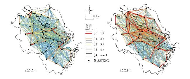
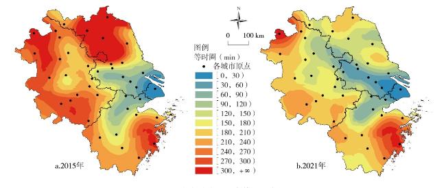
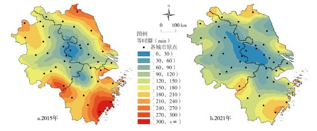
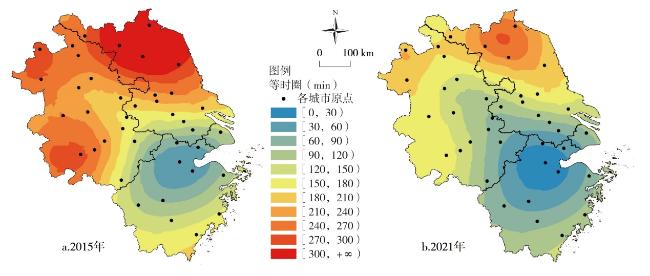
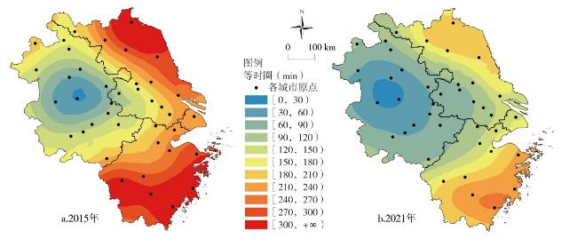
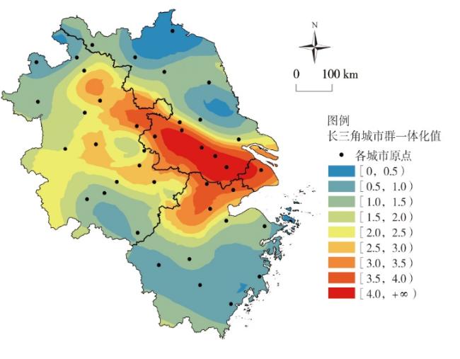
From the perspective of regional spatiotemporal compression,this article constructs a comprehensive transportation accessibility model to measure the shortest time distance and its changes between 41 municipal-level cities in the Yangtze River Delta region. Based on the methods of Delphi and isochronous circle,this article explores the spatial heterogeneity of the integration level of the Yangtze River Delta urban agglomeration from the three dimensions of municipal level,metropolitan level and urban agglomeration level,which provides a reference basis for the formulation of integration plans and policies in the Yangtze River Delta region. The main findings are as followings: 1) In the context of traffic integration construction,the construction and opening of high-speed railway and inter-city railway have significantly shortened the time distance between cities,made the intercity social and economic exchanges more close,and the number of city pairs within one hour has increased sharply. 2) The regional high-level integration areas are concentrated in the Shanghai-Nanjing axis belt and Shanghai-Hangzhou axis belt,the integration level of cities along the Yangtze River Economic Belt is high. 3) Under the spatiotemporal compression effect,regional central cities expand the geographical scope of "spillover effect" and "one-city effect". 4) The spatial heterogeneity of integration in the Yangtze River Delta region has changed with the continuous improvement of the high-speed transportation network. Cities such as Hangzhou,Wuxi,Suzhou,and Hefei have gradually become emerging core cities in the Yangtze River Delta region,and the role of cities such as Wuhu and Anqing in the urban network is also gradually strengthening.
WANG Liang , JIANG Haibing , LIU Binzhang . Multi-scale Analysis and Spatial Effect of Transportation Integration in the Yangtze River Delta[J]. Economic geography, 2024 , 44(1) : 99 -106 . DOI: 10.15957/j.cnki.jjdl.2024.01.010
| [1] |
陈雯. 长三角一体化发展示范区具有战略和现实意义[N]. 第一财经日报, 2019-03-26(A11).
|
| [2] |
陈雯, 孙伟, 刘崇刚, 等. 长三角区域一体化与高质量发展[J]. 经济地理, 2021, 41(10):127-134.
|
| [3] |
张兆安. 长三角一体化发展的新机遇与新挑战[J]. 人民论坛, 2021(11):64-67.
|
| [4] |
王端鹏. 传达学习习近平总书记在首届中国国际进口博览会开幕式上的主旨演讲精神[N]. 济南日报, 2018-11-11(1).
|
| [5] |
吴昊. 加快推动长三角省际毗邻区域协同发展[N]. 中国县域经济报,2021-03-15(1).
|
| [6] |
安蓓. 2025年我国基本建成“轨道上的长三角”[J]. 城市轨道交通研究, 2020, 23(5):191.
|
| [7] |
肖金成. 长三角城市群一体化与高铁网络体系建设[J]. 发展研究, 2014(5):8-12.
|
| [8] |
郭向阳, 穆学青, 丁正山, 等. “交旅”融合下旅游效率与高速交通协调格局研究——以长三角41市为例[J]. 地理研究, 2021, 40(4):1042-1063.
|
| [9] |
王少剑, 高爽, 王宇渠. 基于流空间视角的城市群空间结构研究——以珠三角城市群为例[J]. 地理研究, 2019, 38(8):1849-1861.
|
| [10] |
赵朝, 潘豫, 刘冠群. 基于引力模型的长吉图开发开放先导区城市一体化测度[J]. 统计与决策, 2018, 34(6):102-105.
|
| [11] |
王亮, 刘慧, 宋明洁, 等. 基于“耦合距离”的长江中游城市群一体化空间范围定量测度[J]. 长江流域资源与环境, 2019, 28(12):2827-2837.
|
| [12] |
王娜, 王兆林, 周洪, 等. 成渝经济区城市群空间异质性特征分析[J]. 资源开发与市场, 2019, 35(3):366-374.
|
| [13] |
|
| [14] |
陈伟. 基于可达性的中国城市群空间范围识别研究[J]. 地理研究, 2020, 39(12):2808-2820.
|
| [15] |
徐彩睿, 但婷, 何静, 等. 高铁联网背景下城市可达性空间格局演变[J]. 现代城市研究, 2020(2):61-66.
|
| [16] |
曾群华, 徐长乐, 邓江楼, 等. 沪苏嘉一体化进程中的同城化研究[J]. 华东经济管理, 2012, 26(3):53-56.
|
/
| 〈 |
|
〉 |